How Columbus began
Columbus began as two towns facing each other across the Scioto. Lucas Sullivant, a Virginia surveyor paid in land for laying out the Virginia Military District, platted Franklinton on the west bank in August 1797, watched a flood carry off the first plat in 1798, and rebuilt on higher ground; Franklinton was the seat of Franklin County from 1803 to 1824. On February 14, 1812 the General Assembly accepted an offer from four landowners - Lyne Starling, John Kerr, Alexander McLaughlin and James Johnston - to build a statehouse and a penitentiary on the wooded high bank opposite Franklinton at the forks of the Scioto, and six days later gave the town that did not yet exist the name Columbus. It was a borough in 1816, a chartered city in 1834, a canal and National Road town in the 1830s, a railroad and buggy-making city by the 1880s, and after 1950 it grew by requiring any neighbourhood that wanted its water and sewers to be annexed first. That policy made it 223 square miles and 905,748 people at the 2020 census, the largest city in Ohio and the fourteenth largest in the country.
Settled 1797 (Franklinton, west bank of the Scioto, laid out by Lucas Sullivant in August; first family, Joseph Dixon, autumn 1797), platted 1812 (Columbus, east bank; surveyed by state Director Joel Wright with Joseph Vance; first public sale of lots June 18, 1812), incorporated borough February 10, 1816; chartered as a city March 3, 1834, by Lucas Sullivant founded Franklinton; the four proprietors of Columbus were Lyne Starling of Franklin County, John Kerr of Ross County, Alexander McLaughlin of Muskingum County and James Johnston of Washington County.
Where the name comes from
The town was named for Christopher Columbus by a joint resolution of the Ohio General Assembly passed February 20, 1812, six days after the act fixing the capital on the east bank of the Scioto. Alfred E. Lee, writing the city's history in 1892 with the legislative record in front of him, called the christening unceremonious and recorded no debate about the name; modern accounts agree that no reliable explanation survives for why an explorer with no connection to Ohio was chosen, beyond a tradition that a legislator who admired him talked his colleagues into it. Franklinton across the river had been named in 1797 for the recently dead Benjamin Franklin, whom Sullivant admired. The older names on the ground were Native: the Scioto, whose meaning John Brickell could not give even after four years among the Lenape, and the Whetstone, the Lenape keenhongsheconsepung or sharp-tool river, which the General Assembly renamed Olentangy in 1833 by attaching to it a name that actually belonged to Big Darby Creek.
Before the town
The forks of the Scioto and the Olentangy were Native ground for at least three thousand years before Lucas Sullivant put a compass on them. James Linn Rodgers, who surveyed what was left of the earthworks for Alfred Lee's 1892 city history, wrote that Franklin County had once held nearly a hundred distinct mounds and enclosures and that by his day only a handful survived the plough, the road engineer and the gravel pit. The builders were the Adena of the late Archaic and Early Woodland periods, roughly 800 BC to AD 100, followed by Hopewell and then Fort Ancient peoples; the Ohio historical marker at Campbell Memorial Park describes them as hunters, gatherers, traders and farmers who raised burial mounds of earth, stone, human remains and grave goods on uplands above major waterways. One such mound survives inside the city: Shrum Mound, about 20 feet high and 100 feet across, on the high west bluff of the Scioto at 3141 McKinley Avenue, deeded to the Ohio Historical Society in 1928 by the educator Minnie R. Shrum and never excavated. The greatest of the local mounds did not survive. It stood at the crest of the east bluff at High and Mound Streets, was reckoned at forty feet high with a base perhaps three hundred feet across, carried oak trees three feet through and a large double frame house on its flat summit, and was cut in two by excavators working from north and south until High Street ran straight through it. Its clay went into the bricks of the town: Lee records that the clay for the bricks of Ohio's first statehouse at Columbus, built in 1814 on the corner of State and High, was obtained in part from that mound. Joseph Sullivant, the founder's son, told the Franklin County Pioneer Society in 1871 that other mounds had stood on the bottom land near the junction of the rivers, one in the middle of Franklinton and one where the Ohio Penitentiary was later built, and that parallel lines of embankment had run near the old Franklinton site; nothing of any of them remains. Charles Whittlesey mapped circular works of about 800 and 500 feet diameter on the Harrisburg Road three miles southwest of town, and a fifteen-foot mound stood on the east terrace of Alum Creek about two hundred yards south of the Broad Street extension until it was quarried for gravel in the 1880s. In the historic period the forks were a crossing point rather than a boundary. A Mingo (Seneca-Cayuga) town stood at the forks with Shawnee villages to the south and Wyandot and Lenape (Delaware) villages to the north, and the Scioto Trail - the great north-south path from the mouth of the Scioto at Portsmouth to Sandusky Bay, which connected Shawnee hunting grounds in Kentucky with Lake Erie - ran past them. Joseph Sullivant, working from what three former captives told him, placed three encampments in the immediate neighbourhood: one on the high bank near the old Morrill House a mile and a half below the city, one at the west end of the Harrisburg bridge, and the principal one on the river below the mouth of the Whetstone near the site of the Ohio Penitentiary. In the autumn of 1774, during Dunmore's War, Colonel William Crawford was sent from Dunmore's camp with 240 men against Mingo towns up the Scioto; Sullivant and Lee identified the target as the towns at the forks, and Sullivant recorded from Jonathan Alder the account of a woman shot down crossing to the wooded island opposite while her child hid two days in a hollow sycamore. Lee's account of the raid rests on Sullivant's identification rather than on a document naming the forks, and the location of Crawford's 'Salt Lick town' is not certain. John Brickell, taken from the Allegheny on February 9, 1791 at the age of nine and raised by the Lenape man Whingwy Pooshies, was released at Fort Defiance about June 1, 1795 under the peace that produced the Treaty of Greenville, came to the forks in 1797, and lived the rest of his life in a cabin on ten acres where the Ohio Penitentiary later fronted. He left the Lenape names of the local streams: Alum Creek was Seckle Sepung, Saltlick Creek, and Big Walnut was Whingwy Mahoni Sepung, Big Lick Creek. The Treaty of Greenville, signed August 3, 1795 after Fallen Timbers, extinguished Native title here and opened the ground to survey; Congress had already set aside the Refugee Tract, 103,527 acres running 42 miles east from the Scioto, for Canadians and Nova Scotians who had helped the Revolution, and the Columbus plateau itself was patented in 1802 to five of those refugees - John Halstead, Martha Walker, Benjamin Thompson, Seth Harding and James Price - whose titles passed to the four proprietors. Native residence did not end with the treaty. Kihue, known as Bill Moose, born in Ohio in 1837 and a Wyandot whose family was among the dozen that refused to remove to Kansas in the 1840s, joined the Sells Brothers Circus in 1878, came back to central Ohio in 1915, lived first in a cave in the Overbrook (Adena) Ravine and then in a cabin neighbours built him at Indianola and Morse Roads, told stories to the children of the north side, and died on July 12, 1937 a few months short of a hundred. Tens of thousands are said to have followed his funeral. Bill Moose Run, one of the six glacial ravines that cut through Clintonville to the Olentangy, carries his name; his grave is on the Scioto bluff a little north and west of the city line, under a stone tepee.
Nations recorded here: Wyandot, Shawnee, Lenape (Delaware), Mingo (Seneca-Cayuga), Miami, Adena culture, Hopewell culture, Fort Ancient culture.
- Shrum Mound (Campbell Mound) (mound) — Campbell Memorial Park, 3141 McKinley Avenue, on the high west bluff of the Scioto in the West Scioto neighbourhood, half a mile south of Trabue Road, Adena, c. 800 BC to AD 100 (en.wikipedia.org)
- Shrum Mound as recorded in 1892 (mound) — then described as on the Shrum farm near the Dublin Pike, a quarter mile from Marble Cliff, about 15 feet high and 80 feet at the base, overgrown and unexplored, prehistoric; Adena (archive.org)
- The High and Mound Street mound (mound) — the crest of the east bluff at the southeast corner of High and Mound Streets, downtown, where St. Paul's Lutheran Church later stood; destroyed when High Street was cut through, its clay used in part for the bricks of the first statehouse, prehistoric; moundbuilder (archive.org)
- Mingo town at the forks of the Scioto (village) — at the junction of the Scioto and the Whetstone (Olentangy); burned by colonial militia in 1774, 18th century (en.wikipedia.org)
- The principal village below the mouth of the Whetstone (village) — on the river below the confluence, near the site of the Ohio Penitentiary where John Brickell's cabin later stood; located by Joseph Sullivant from the testimony of Brickell, Jeremiah Armstrong and Jonathan Alder, 18th century (archive.org)
- Village near the old Morrill House (village) — on the high bank a mile and a half below the city; the party that captured Lucas Sullivant's surveying company on Deer Creek in 1795 was said to have come from here, 18th century (archive.org)
- Village at the west end of the Harrisburg bridge (village) — south-west of the forks on the Scioto, 18th century (archive.org)
- The Scioto Trail (trail) — ran along the Scioto through the forks; U.S. Route 33 follows its route north from the confluence of the Scioto and Olentangy. The trail ran from the mouth of the Scioto at Portsmouth to Sandusky Bay and connected Shawnee hunting grounds in Kentucky with Lake Erie, pre-contact into the 18th century (hmdb.org)
- Mounds on the bottom land at the forks (mound) — one in the central part of Franklinton, one where the Ohio Penitentiary was built, and several smaller ones south of these on the west side of the river; all quarried away by settlers for earth and gravel, prehistoric (archive.org)
- Parallel embankments at old Franklinton (earthwork) — near the original Franklinton site, reported by Joseph Sullivant; gone before 1892, prehistoric (archive.org)
- The Pope Mound (mound) — on the Scioto terrace about two and a half miles north-west of the Statehouse, 21 feet high, 111 feet at the base and 50 feet across the flat summit; the best preserved in the county in 1892, with stone curbing and burned clay found at its east side, prehistoric (archive.org)
- Alum Creek terrace mound (mound) — on the crest of the east terrace of Alum Creek about two hundred yards south of the Broad Street extension; 15 feet high and 75 feet at the base until it was opened as a gravel bed in the late 1880s, prehistoric (archive.org)
- Harrisburg Road circles (earthwork) — about three miles south-west of Columbus on a low clayey plain, two near-circular ditched enclosures of roughly 800 and 500 feet diameter surveyed by Colonel Charles Whittlesey for the Smithsonian; barely traceable by 1892, prehistoric (archive.org)
- Treaty of Greenville cession (treaty) — the whole of the Scioto forks lay south and east of the Greenville line drawn on August 3, 1795 after the Battle of Fallen Timbers, and so passed out of Native title before Sullivant returned to plat Franklinton, 1795 (en.wikipedia.org)
- Bill Moose (Kihue) cabin and grave (other) — his cabin stood at Indianola and Morse Roads on the north side; earlier he lived in a cave in the Overbrook (Adena) Ravine. Bill Moose Run in Clintonville is named for him. He is buried under a stone tepee on the Scioto bluff on Riverside Drive north-west of the city, 1837-1937 (hmdb.org)
Timeline
- — The Treaty of Greenville, signed August 3, extinguishes Native title in most of Ohio, and Lucas Sullivant is employed by Virginia to survey the central Ohio portion of the Virginia Military District, taking 6,000 acres in payment.
- — In August, Lucas Sullivant lays out Franklinton on the west bank opposite the forks, 220 lots in a grove of walnut trees beside bottom land the Native women of the neighbourhood had planted with corn for decades; Joseph Dixon brings the first family that autumn.
- — A great flood submerges the first Franklinton plat before the lots can be sold; Sullivant replats the town on higher ground inland and gives away lots on Gift Street to anyone who will build.
- — The plateau on the east bank is patented to five Refugee Tract claimants - John Halstead, Martha Walker, Benjamin Thompson, Seth Harding and James Price - whose titles pass by sale to the men who will offer the ground to the state ten years later.
- — Franklin County is struck off Ross County and Franklinton becomes its seat of justice, which it remains until the seat crosses the river to Columbus in 1824 and Franklinton begins its long decline into a village on the wrong side of the water.
- — On February 14 the General Assembly, sitting at Zanesville, accepts the proposal of Lyne Starling, John Kerr, Alexander McLaughlin and James Johnston to lay out a town on the east bank opposite Franklinton and to build a statehouse, offices and a penitentiary there for $50,000.
- — On February 20 a joint resolution names the unbuilt town Columbus and appoints Joel Wright of Warren County as state Director to survey it; the streets are laid twelve degrees west of north, High Street 100 feet wide and Broad Street 120, and the first public sale of lots opens on the premises on Thursday, June 18, in what was still dense forest used as a hunting ground.
- — Franklinton becomes the staging ground for General William Henry Harrison's Army of the Northwest; one to three thousand troops are quartered there at a time, and the Harrison House at 570 West Broad Street, built in 1807, shelters his officers.
- — General Harrison and the Wyandot chief Tarhe meet at Franklinton on June 21 under an elm near the later site of Mount Carmel hospital and agree to end the fighting between their peoples.
- — Ohio's first statehouse at Columbus, a plain two-storey brick building 75 feet by 50, is finished on the corner of State and High; the clay for its bricks comes in part from the great mound at High and Mound Streets, and the freestone trim is hauled twelve miles from Black Lick through the swamps.
- — Columbus is incorporated as a borough on February 10; the General Assembly meets in the town for the first time and Jarvis W. Pike, who had cleared and farmed Capitol Square for its timber, serves as the first appointed mayor.
- — Water is let into the Columbus Feeder of the Ohio and Erie Canal on Tuesday, September 13; at eight in the evening on Friday the 23rd cannon announce the arrival of the canalboat Governor Brown from Circleville, and the first mile of the feeder had been dug by forty-five penitentiary convicts who took the work in exchange for commuted punishment.
- — The National Road reaches Columbus from Baltimore; contracts had been let the year before for grading twenty-six miles east of town from the canal and fourteen miles west toward the Big Darby, and by 1831 seventy stagecoaches a week were arriving in the borough.
- — Cholera reaches Columbus. Josiah Stagg dies on July 14, deaths are reported almost daily until the end of September, and the Board of Health's final list on November 2 counts a hundred dead in a town of about three thousand; the outbreak produces the city's first Board of Health.
- — Columbus is chartered as a city on March 3 with a population of 3,500; John Brooks is elected the first popularly chosen mayor in April.
- — The new Ohio Penitentiary opens on the ten-acre plot the 1812 proprietors had deeded the state on Scioto Lane, replacing the thirteen-cell prison finished in 1815 whose first inmates, the brothers John and David Evans, had arrived on August 15 of that year; a separate women's prison is built inside its walls in 1837.
- — The cornerstone of the present Ohio Statehouse is laid on July 4 with no final design agreed; Capitol Square's picket fence is replaced by a high board fence built to screen the convicts working on the building.
- — The landscape architect Howard Daniels designs the original portion of Green Lawn Cemetery, which grows to more than 360 acres and holds Lucas Sullivant, Simon Lazarus, James Poindexter, Eddie Rickenbacker and James Thurber; the cholera of the following year begins filling it.
- — The worst cholera summer in the city's history: 162 deaths reported in town from June to September 12, and 116 more in the Penitentiary, where 22 men died on July 10 alone and the prison physicians Doctor Gard and Doctor Horace Lathrop both died of the disease.
- — The Columbus and Xenia Railroad becomes the first railroad into the city; the Cleveland, Columbus and Cincinnati follows in 1851 and the two build a joint station north of Naghten Street, the first union station in the world.
- — Simon Lazarus opens a one-room men's clothing store downtown; his sons build it into the department store that will dominate central Ohio retail for a century and a half.
- — The Ohio Statehouse opens to the public on January 7 after eighteen years of construction, five years after fire destroyed the old two-storey statehouse and scattered the state offices around town; the rotunda is still unfinished, Isaiah Rogers is brought in to complete it, and Capitol Square is not finished until 1861, twenty-two years and about $1.3 million after the cornerstone was laid.
- — Franklinton is absorbed into Columbus. The date is disputed: the city's own article gives 1837, the Franklinton neighbourhood history gives 1859, and the 1947 sesquicentennial marker on West Broad Street says 1870.
- — Camp Chase is established in May 1861 on leased land on the National Road four miles west of downtown, on ground now bounded by Broad Street, Hague Avenue, Sullivant Avenue and Westgate Avenue in the Hilltop; Columbus houses 26,000 Union troops, and as many as 150,000 Union soldiers and 25,000 Confederate prisoners pass through the camp, which held over 9,400 men by February 1865.
- — The Ohio Agricultural and Mechanical College is founded under the Morrill Act on the former estate of William and Hannah Neil north of town; it opens to twenty-four students on September 17, 1873 and is renamed the Ohio State University in 1878.
- — Clinton D. Firestone and the brothers George and Oscar Peters form the Columbus Buggy Company with $20,000 at Wall and Locust Streets; in its first year it draws $50,000 in revenue, and by 1878 it has 250 employees making a hundred buggies a week.
- — Joseph A. Jeffrey and F. C. Sessions buy Francis Lechner's coal-cutting patent and found the Lechner Mining Machine Company; renamed the Jeffrey Manufacturing Company in 1880 and moved to Milo-Grogan, it becomes the largest maker of mining locomotives and coal cutters in the world.
- — Samuel Gompers founds the American Federation of Labor in Druid's Hall on South Fourth Street in 1886, and the United Mine Workers of America is founded at the old City Hall in 1890.
- — Daniel Burnham's Union Station opens, its Beaux-Arts arcade of shops and offices facing High Street from a viaduct that finally lifts the road over the thirteen tracks; the arcade is completed in 1899.
- — Griggs Dam is completed on the Scioto at a cost of $700,000, named for the city's chief engineer Julian Griggs; for twenty years it is the only reservoir supplying Columbus.
- — The Columbus Experiment: the brothers Clarence and Charles Hoover design the first water plant in the world to combine filtration with softening, cutting typhoid deaths sharply; Jeremiah O'Shaughnessy, superintendent of the Division of Water, is among those who built it.
- — The streetcar strike: 600 union men walk out at 4 a.m. on July 24 against nineteen-cent hours and sixty-five-hour weeks; crowds barricade tracks and dynamite empty cars, Mayor George Marshall calls in 5,000 Ohio National Guard, and the union concedes defeat on October 18.
- — The Great Flood. About five inches of rain falls in twenty-four hours from late on March 24; at 10 a.m. on March 25 the earthen State Levee opposite the Ohio Penitentiary gives way, putting 7 to 17 feet of water over Franklinton, killing at least 93 people, leaving 20,000 homeless and destroying every downtown bridge but the condemned Rich Street span.
- — The wooden arches that had spanned High Street and earned Columbus the name Arch City are torn down and replaced with cluster lights; metal arches are raised again over the Short North in 2002 for their historical interest.
- — Anti-German feeling peaks in the old South End: German is banned in the public schools, German books are burned on Broad Street and at the foot of the Schiller statue, Germania Street becomes Stewart Avenue and Schiller Park is renamed Washington Park.
- — Ohio Stadium opens on the Olentangy; the first game, against Ohio Wesleyan on October 7, draws about 25,000 into a horseshoe that looks half empty, and the formal dedication against Michigan two weeks later draws a reported 72,000.
- — On April 21 a fire started by a candle among oily rags on the roof of the six-storey West Block kills 322 inmates of the Ohio Penitentiary and hospitalises 230 more, one of the deadliest prison fires in North American history; guards who refused to unlock cells were blamed, and 500 soldiers from Fort Hayes ringed the walls with machine guns.
- — Poindexter Village opens on the near East Side on October 12 with President Franklin Roosevelt at the ceremony: 400 units in 35 buildings on 27 acres, the first public housing in Columbus and among the first in the country, named for the abolitionist minister James Preston Poindexter. Thirty-three of its buildings are demolished around 2013; the last two are bought by the Ohio History Connection in 2017 and made a state historic site in July 2021.
- — B & T Metals in East Franklinton is contracted to extrude about fifty tons of uranium for the Hanford reactor between March and August; the workers are given weekly physicals and no radiation protection. The site is remediated in 2001.
- — The Park of Roses is laid out on 13.5 acres of Whetstone Park in Clintonville, established April 19, 1952 and opened June 6, 1953 with 20,000 plants; the American Rose Society moves its headquarters and the world's largest rose library from Hartford to Columbus.
- — Hoover Dam is built on Big Walnut Creek in Blendon Township for the water demand of postwar Columbus - begun 1953, dedicated 1955, opened 1958 - and named for the brothers Charles P. and Clarence B. Hoover of the Columbus waterworks.
- — Jack Sensenbrenner takes office as mayor after an upset win, and makes annexation the price of a city water tap; the policy runs through his terms of 1954-1960 and 1964-1972 and adds more than a hundred square miles to Columbus.
- — The last major Franklinton flood: the Scioto crests 27.22 feet above flood stage at Frank Road on January 22 over frozen ground. The Franklinton branch library on Sullivant Avenue is closed for weeks by flood and fire damage while the furnace is rewired.
- — German Village becomes a city historic district in 1960 and Frank Fetch's German Village Society holds the first Haus und Garten Tour that June, showing eight restored houses and two gardens in a neighbourhood the city had lately proposed to demolish by the third; it is listed on the National Register in 1974 as the largest privately funded preservation district on it, and more than 1,600 buildings are restored.
- — Construction of Interstate 71 cuts through Bronzeville on the near East Side; the highway becomes the neighbourhood's western boundary and begins the decline of what had been the city's largest and most self-contained Black community.
- — The Martin Luther King Jr. branch of the Columbus Metropolitan Library is dedicated on East Long Street in November, the first public library in the United States named for King, dedicated by his father months after the assassination and designed by Leon Ransom Jr. of the city's first Black-led architecture firm.
- — On the evening of Friday, October 22, wreckers hired by the Battelle Memorial Institute take down almost the whole Union Station arcade overnight; a restraining order won by the Ohio Historical Society stops the machines the next day with one arch standing.
- — The last train leaves Columbus Union Station on the morning of April 28, a westbound National Limited for Kansas City at 9:17; the station itself is demolished in September 1979 and the National Limited is cut a month later, ending about 130 years of intercity rail service to the city.
- — The Short North Tavern opens on High Street, the first business to use a name that police and taxi drivers had coined for the stretch that fell just short of downtown; galleries follow, and two of them begin the monthly Gallery Hop in 1984.
- — The last inmate leaves the Ohio Penitentiary in August after 150 years; the buildings stand empty for more than a decade and are demolished in 1997, and Nationwide redevelops the site as the Arena District.
- — AmeriFlora '92 marks the Columbus quincentennial; Native leaders hold a day of mourning and fasts at City Hall, and their protests stop the planned replica Native village from being exhibited. Annual fasts continue until 1997.
- — Michael B. Coleman is elected the city's first African American mayor; he serves sixteen years, longer than anyone else, and pushes redevelopment of the riverfront, the Arena District and Franklinton.
- — Easton Town Center opens in north-east Columbus in the summer of 1999, one of the first lifestyle centres in the country, built by Les Wexner's Limited Brands with the Georgetown Company on a mock town grid; Polaris Fashion Place follows in November 2001 on the Delaware County side of the northern city limit, and Northland Mall, whose three anchors moved there, closes on October 31, 2002 and is demolished in February 2004.
- — The Franklinton floodwall is dedicated in March, eleven years after the Columbus Day groundbreaking of 1993 and eighteen after the Army Corps first recommended it: 7.2 miles long, $134 million, able to hold a Scioto crest of 30.9 feet. It lifts the floodplain designation from most of the neighbourhood and building resumes for the first time since 1983.
- — The Lazarus name disappears from central Ohio storefronts when Federated completes the conversion of the chain to Macy's, 154 years after Simon Lazarus opened his one-room shop.
- — The Ohio EPA and the city begin taking out the lowhead dams: the Fifth Avenue Dam on the Olentangy in 2012, which narrows that river to about half its impounded width, and in 2013 the Main Street Dam on the Scioto, built in 1918 to hold back floods and to widen the river downtown, whose removal gives the city back a long strip of shoreline that had been under water since before the First World War and becomes the Scioto Mile.
- — The census counts 905,748 people in Columbus, the fourteenth largest city in the United States and by far the largest in Ohio; the city covers 223.11 square miles, of which 217.17 are land, and the Census Bureau's 2025 estimate of 938,396 is still rising.
- — The COVID-19 pandemic reaches Columbus in February and March and the city declares a state of emergency; protests over the murder of George Floyd run from May 28 into August, and in 2021 the 22-foot Christopher Columbus statue is removed from the south side of City Hall.
- — Intel announces in January that it will build semiconductor fabrication plants on 926 acres annexed into New Albany at the north-east edge of the metropolitan area; construction begins in September 2022.
- — A ransomware attack on the City of Columbus in July 2024 is claimed by the group Rhysida; in January 2025 Anduril announces Arsenal-1, a weapons manufacturing plant in the Columbus area, part of a wave of advanced-manufacturing investment that also brought Honda and LG Energy Solution battery work to the region.
Stories
Franklinton, and the flood that came the first year
Lucas Sullivant came into central Ohio in 1795 with about twenty men and a compass, employed by Virginia to survey the Military District, and paid for it in land. He took the best of what he measured - so much of it that he was known as monarch of all he surveyed - and he kept coming back to the forks of the Scioto because the bottom there was rich, the river was navigable, and the Native people had already chosen it, their women having planted the bend just below the forks with corn for as long as anyone could remember. In August 1797, in a grove of walnut trees skirting those cornfields, he laid out 220 lots and named the town Franklinton for Benjamin Franklin, lately dead. The lots were to be sold on a fixed day. Before the day came, in 1798, the whole lowland went under water and the plat with it. Sullivant moved the town back onto higher ground, redrew it in blocks of four lots each ninety-nine feet wide and a hundred and fifteen deep, and, to get anyone at all to live in a place that had just drowned, gave away the lots along one street to whoever would build a house on them. It is still called Gift Street. He built the county's first brick house there, hauling brick and glass from Philadelphia, and a courthouse, a church and the first bridge over the Scioto; he lived in Franklinton until he died in 1823, and his grave was in the churchyard before it was moved to Green Lawn. The river came back in 1832, 1834, 1847, 1852, 1859, 1860, 1862, 1866, 1868, 1869, 1870, 1875, 1881 and 1883.
Why the capital came to a cornfield
Ohio could not settle on a capital. The 1802 constitution put the government at Chillicothe until 1808 and forbade spending on legislative buildings until 1809; the legislature moved to Zanesville in 1810 and quarrelled about where to go next. A five-man commission toured the state in 1810, visited Franklinton, and threw it out for its low situation and the unsuitableness of its plan, then recommended the Sells brothers' farm on the west bank near present-day Dublin, chiefly because it sat near the geographical centre of the state. That rejection is what produced Columbus. Franklinton's landowners looked across the river at the empty plateau on the east bank - high, wooded, unbuilt, with no existing streets to argue about - and four men who between them held title to it made the legislature an offer no rival town could match: give us the capital and we will lay out a town, deed you ten acres for a statehouse and ten for a penitentiary, and build both at our own expense for fifty thousand dollars. Lyne Starling, John Kerr, Alexander McLaughlin and James Johnston signed a hundred-thousand-dollar bond on February 10, 1812 to guarantee it. Worthington fought hard and was said to have had a majority, but in the closing hours of the session Joseph Foos, Sullivant and other Franklinton men swung it, and on February 14 the General Assembly fixed the seat of government on the high banks opposite Franklinton at the forks of the Scioto - a place Lee describes as dense forestland used only as a hunting ground. Six days later a joint resolution gave it the name Columbus. Lots went on sale on the premises on June 18, 1812, in the woods.
The mound at High and Mound
The largest ancient work in Franklin County stood at the crest of the east bluff where High Street crosses Mound Street. James Linn Rodgers, who wrote the earthworks chapter of Alfred Lee's 1892 history, reckoned it at fully forty feet above the natural terrace, a truncated cone perhaps three hundred feet across the base with a level top a hundred feet wide - so large that a Doctor Young built a big double frame house on the summit and later families lived in it, and oak trees three feet through grew on its slopes. When the first settlers came it was regarded as a wonder. It was not spared. Two gangs of excavators cut into it from the north and the south until they met and High Street ran straight through. The outer clay and the gravel and sand beneath went into the beds of the neighbouring streets; human bones came up and crumbled in the air, and a silver buckle was turned by somebody's spade, which Rodgers thought had belonged to a historic-period Indian who had traded with the French or English. Some of the mound's clay went into brick: Lee records that the bricks of Ohio's first statehouse at Columbus, the plain two-storey building finished in 1814 at State and High, were made in part from clay taken out of that mound. The city's capitol, in other words, was built partly out of a Native burial place, three blocks away. Nothing of the mound remains but the terraces of the church that replaced it and the name of the street.
The Statehouse and the men who built it behind a fence
Ohio held a design competition for its capitol in 1838 and could not decide: first prize went to Henry Walter of Cincinnati, second to Martin Thompson of New York, third to the painter Thomas Cole, and the commission then failed to agree on any of them. The cornerstone was laid on July 4, 1839 with no final design in hand. Almost at once the law making Columbus the capital came up for renewal, work stopped while the legislature argued about moving again, the open excavations were filled back in, and Capitol Square went back to being pasture for livestock. In 1834 the square had been fenced presentably with cedar posts and white palings and planted with elms brought in from the forest; in 1839 that fence was replaced with a higher one of rough boards, built for one purpose - to screen the convicts at work on the Capitol from the town. Prisoners sentenced to hard labour dug and laid the foundations, which go down thirteen feet. Work resumed in May 1848 under William Russell West and J. O. Sawyer, paused for a cholera epidemic that emptied the town, and paused again each hard winter. When fire took the old statehouse in 1852 the state offices scattered across town and the pressure told. The building opened to the public on January 7, 1857, eighteen years after the cornerstone, and the whole of Capitol Square was not finished until 1861, twenty-two years and about $1.3 million in. Isaiah Rogers, brought in at the end, declined to put a dome on it; critics called the low conical roof a Chinese hat, and it is still there.
Camp Chase and the Confederate cemetery in the Hilltop
In May 1861 the government leased ground on the National Road four miles west of downtown and named the camp for Salmon P. Chase, the former Ohio governor then serving as Lincoln's Treasury Secretary. Its boundaries were roughly what are now Broad Street on the north, Hague Avenue on the east, Sullivant Avenue on the south and Westgate Avenue on the west. It was a training camp, a parole camp, a mustering point and, increasingly, a prison. As many as 150,000 Union soldiers passed through, along with 25,000 Confederate prisoners; four future presidents - Johnson, Hayes, Garfield and McKinley - passed through it as well. By February 1865 more than 9,400 prisoners were held there. Prisoners were not deliberately starved, but the army fed its own first, and crowding produced a smallpox outbreak that killed hundreds in the winter of 1863-64. The camp closed in 1865 and was pulled down; its usable buildings went to Dayton in 1867 to help build the National Asylum for Disabled Volunteer Soldiers. What is left above ground is two acres of cemetery holding 2,260 Confederate graves, one of the largest Confederate burial grounds in the North. A former Union soldier, William H. Knauss, organised the first memorial service there in 1895 and published a history of the camp in 1906. The memorial arch went up in 1902; the United Daughters of the Confederacy held annual services from 1912 to 1994 and the Hilltop Historical Society sponsors them now. On August 22, 2017 vandals pushed the soldier statue off the arch and broke off its head, taking the head and leaving the hat; it was repaired and reinstalled in May 2019. The rest of the camp is a 1920s and 1930s subdivision called Westgate.
March 25, 1913: the levee goes at ten in the morning
The rain began on Easter Sunday, March 23, and by the small hours of March 25 about five inches had fallen in twenty-four hours on ground that had never fully thawed after a cold winter. The newspapers on the 24th had printed a forecast saying there was no danger of damaging storms in this vicinity. By two in the morning it was clear a major flood was coming; by dawn police and firemen were pulling people out in water to the knee. At ten o'clock the earthen State Levee, across the river from the Ohio Penitentiary, gave way under the pressure, and most of Franklinton went under seven to seventeen feet of water within minutes. Houses came off their foundations. People climbed into attics and then into trees, and when the temperature dropped that night, some of the exhausted let go and fell into the water. Robert F. Wolfe, publisher of the Columbus Evening Dispatch, watched the river rise from his office, remembered that his boats were in winter storage at Buckeye Lake, chartered an interurban train and brought back nine motorboats and twenty rowboats to the water's edge at Rich and Scioto. The current was too fast to launch rescue boats at all until Thursday. At least 93 people died and 20,000 were left homeless; 4,072 Franklinton houses flooded, many to the second floor; every bridge downtown went out except the Rich Street bridge, which had already been condemned. The city shut down for five days and the west side for six weeks; early damage estimates of $5 million eventually climbed to $22 million. Columbus historian Ed Lentz calls it the worst catastrophe in the city's history.
Ninety-one years to build a wall
The 1913 flood produced the answer that shaped downtown: in 1916 voters approved a $3.5 million plan, the Scioto through the centre of the city was doubled in width and its channel deepened, new bridges went up and the civic centre was built behind a retaining wall on the east bank. Franklinton, on the low side, got levees and not much else. Business and people moved uphill to the Hilltop, property values on the west side fell by half, and the neighbourhood never got them back. The river came again in January 1959, cresting 27.22 feet above flood stage at Frank Road over frozen ground, closing the Franklinton branch library on Sullivant Avenue for weeks while its furnace was rewired and its structure repaired. Columbus joined the federal flood insurance programme in 1971, and in 1983 FEMA drew nearly all of Franklinton inside the hundred-year floodplain; city council then restricted new construction, which froze the neighbourhood in place for twenty years. The Army Corps recommended a floodwall in 1986 at an estimated $30.9 million, design money came in 1988, the first contract was let in 1993, and politicians broke ground on Columbus Day that year. Federal funding was cut and restored more than once through the 1990s. The finished wall was dedicated in March 2004: 7.2 miles, $134 million, rated for a crest of 30.9 feet. About 700 of the 2,800 acres behind it are still at risk from poor drainage and still carry building restrictions and insurance requirements.
Arthur Boke Jr.
In 1803 Sarah Sullivant had just given birth to a son in Franklinton when, a few days later, an abandoned baby - the child of an enslaved woman - was left at her door. She took him in and nursed both children. The Sullivants named him Arthur Boke Jr. and raised him as a son and a brother; he lived in the household until his death in 1841, and Lucas and Sarah's children, particularly Joseph, made sure he was buried in the family plot, which in that time and place was a public statement about who counted as family. The story is the reason Franklinton claims the first African American resident of what became Columbus. It has been retold enough to have acquired the smoothness of legend, and the version on the monument is a piece of civic commemoration rather than a document, but the burial in the Sullivant plot is the part that is hard to invent. In 2004 the Hungarian-born Holocaust survivor and sculptor Alfred Tibor donated a bronze group called Celebration of Life, put up at Broad Street and Washington Boulevard near the west bank of the Scioto by the Franklinton Historical Society, the Hilltop Historical Society and the Greater Hilltop Community Development Corporation, with a poem by the Columbus poet Buelina Murphy on its base. Tibor's dedication reads that he gained freedom when he came to the United States and that he gave the work to tell coming generations to celebrate life.
Buggy Capital of the World
In 1870 two brothers from the leather trade, George and Oscar Peters, had worked out how to build a serviceable buggy for about $150, sold a hundred of them at auction, and been abandoned by their backers. Clinton D. Firestone of Canton put up $5,000, and the three of them started in a shanty on North High Street that cost a hundred dollars to build. They sold 237 buggies the first year. In 1875 they formed the Columbus Buggy Company with $20,000 at Wall and Locust Streets, next door to the Ohio Penitentiary and Union Station, and the thing took off: 250 employees and a hundred buggies a week by 1878, a thousand employees and 25,000 buggies a year by 1883, and at its height in 1892 twelve hundred people making a hundred vehicles and fifteen hundred dashboards a day, $2 million a year in revenue and a payroll of $300,000 a month. By 1900 about two dozen buggy makers were working day and night in Columbus and an estimated one buggy in six anywhere in the world was built here. Two of the men who passed through the works changed the century: Harvey S. Firestone, a salesman and Clinton's cousin, noticed what thick rubber tyres did for a carriage and left in 1900 to found the Firestone Tire and Rubber Company in Akron, and a seventeen-year-old troubleshooter named Eddie Rickenbacker learned to drive fast testing the company's cars. The firm went electric in 1903 and gasoline in 1909 with the Firestone-Columbus, entered the Indianapolis 500 in 1911 and 1912, and then the Scioto came over the Dublin Road plant in March 1913. It filed for bankruptcy $624,000 in debt, was reorganised, and closed in 1915 with thirty-five unsold electric cars in stock.
The Lazarus store
Simon Lazarus opened a one-room men's clothing shop in downtown Columbus in 1851. Civil War contracts for uniforms taught American factories to make clothing in standard sizes, and by 1870 the family was selling ready-made civilian clothes; from there it became a full department store. His sons Fred Sr. and Ralph brought in the marketing that made the name: one price, no haggling; the first department store escalators in the country; the first air-conditioned store in the country. Fred Lazarus Jr. went further than retail - he lobbied Franklin Roosevelt to fix Thanksgiving permanently on the fourth Thursday in November so the Christmas shopping season would start on a predictable date, and won. The company bought Cincinnati's John Shillito Company in 1928 and in 1929 was one of four founders of Federated Department Stores, alongside Filene's and Abraham & Straus. In central Ohio Lazarus was not simply dominant; by 1982 it had outlasted the last of its traditional local rivals. In 1989 the sprawling downtown flagship became an anchor of the Columbus City Center mall, reached by a skywalk over South High Street. Then the consolidation reversed: Lazarus was folded into an Atlanta division in 1995, rebranded Lazarus-Macy's in 2003 and simply Macy's in 2005. Its people had never been called employees. They were called associates.
Bronzeville, and the road that cut it
Black families had been in Columbus since before the Civil War - Second Baptist Church, the first Black Baptist church in the city, dates to 1824, and its pastor from 1858, James Preston Poindexter, was a barber, a minister, a conductor on the Underground Railroad and later the first African American elected to the city council and the first on the board of education. The neighbourhood that residents called Bronzeville, east of downtown along Long Street and Mount Vernon Avenue, filled after the First World War with people coming north in the Great Migration and was hemmed in by restrictive covenants elsewhere in the city, so it built its own everything. By the 1930s it had four theatres - the Lincoln, the Empress, the Cameo and the Pythian - jazz clubs, hospitals, schools, churches and a commercial street of Black-owned businesses; it was where civil rights organisers, including Martin Luther King Jr., gathered when they came to Columbus. The Ogden Theatre had opened at 769 East Long Street on November 26, 1928, built by the local entrepreneur Al Jackson in Egyptian Revival by the architect Carl Anderson, and was renamed the Lincoln in 1939. Poindexter Village opened a few blocks away in 1940 with Roosevelt in attendance. What ended it was not one thing but two arriving together: Interstate 71, built through the district from 1962 and now its western boundary, and the lifting of the covenants, which let the middle class leave. In 2001 the city launched the King-Lincoln District Plan, restoring the Lincoln Theatre and the Pythian as the King Arts Complex and bridging the highway with a Long Street cultural wall of sixty panels and 139 images. In 2009 the neighbourhood association asked that the district simply be called Bronzeville again.
How German Village survived
The land south of downtown was claimed by a Revolutionary veteran named John McGowan by 1802 and sold off in tracts to German immigrants as they arrived; by 1814 it was a settlement they called Das Alte Suedende, the Old South End. Cheap land drew more, and by 1865 a third of Columbus was German. They built breweries along South Front Street - twenty-nine over the years, among them Louis Hoster's City Brewery from the 1830s, Schlegel's Bavarian, Conrad Born's Capital, and August Wagner's Gambrinus - and schools so good that English-speaking families sent their children to them, and Schiller Park with a Munich casting of the Schiller statue, given by residents in 1891. Then it was dismantled twice. The First World War brought a ban on teaching German in the schools, book burnings on Broad Street and at the foot of the Schiller statue in 1918, Germania Street renamed Stewart Avenue, Schiller Park renamed Washington Park, and dachshunds killed and thrown into a pit in the park. Prohibition closed the breweries. The area was rezoned for manufacturing, the streetcar tracks and wrought-iron fences went for scrap in the Second World War, and by the 1950s the city had declared it a slum and decided to demolish a third of it - the third that is now the interstate junction called the Split. Frank Fetch bought a house on South Wall Street anyway, founded the German Village Society, and in June 1960 put eight restored houses and two gardens on a tour. The neighbourhood became a city historic district that year, won a commission with power over exterior changes, and was listed on the National Register in 1974 as the largest privately funded preservation district on it. More than sixteen hundred buildings have been restored since.
Water for annexation
Columbus is 223 square miles because of a plumbing decision. After the Second World War the interstates and cheap mortgages pulled people out to the townships, and every other big Ohio city watched its tax base leave and its boundary freeze. Columbus had one asset the townships could not build for themselves: it held the regional water and sewer rights over a large part of central Ohio, anchored on Griggs Dam of 1905, the O'Shaughnessy upstream, the Hoover reservoir on Big Walnut begun in 1953 and opened in 1958, and the treatment technique the Hoover brothers had invented here in 1908. Jack Sensenbrenner, a former Fuller Brush salesman who won the mayoralty in an upset in 1954, made the rule plain: if a neighbourhood wanted a city water tap, it had to be annexed first. He was mayor from 1954 to 1960 and again from 1964 to 1972, and the city grew by more than a hundred square miles under him. The policy is why Columbus is almost entirely ringed by suburbs and also why several suburbs are entirely landlocked inside it, why the city reaches north across the Franklin County line into Delaware County at Polaris, and why by the early 1990s Columbus was the largest city in Ohio in both area and population. It is also the reason the Ohio Tap Water Atlas has a Columbus system that supplies far more than Columbus.
Taking the dams out
For most of the twentieth century the rivers through Columbus were held behind lowhead dams and were wider, slower and muddier for it. The Main Street Dam went into the Scioto downtown in 1918, part of the post-1913 flood works, and it doubled the width of the river through the centre of the city; the water behind it was stagnant. The Fifth Avenue Dam did the same to the Olentangy. Starting in 2012 the Ohio EPA and the city began taking them out - the Fifth Avenue Dam first, which cut the Olentangy to about half its impounded width and exposed banks that could be replanted - and in 2013 the Main Street Dam and the sediment behind it were removed. The Scioto downtown narrowed, and the city recovered a long strip of shoreline that had been underwater since before the First World War. That new bank is what the Scioto Mile is built on. The park chain had started slowly: Bicentennial Park in 1976, Battelle Riverfront Park in 1983, both cut off from downtown by a five-lane Civic Center Drive, and a replica of the Santa Maria moored at Battelle in 1992 to draw people to a riverfront that had nothing else to offer. Michael Coleman made the riverfront his project after becoming mayor in 2000; Civic Center Drive lost two lanes, and the parks were built out between 2011 and 2015 into nine connected spaces from Genoa Park and Dorrian Green on the Franklinton side to North Bank Park and the Scioto Audubon. A pillar on the Scioto Mile Promenade marks the 1913 high water.
The night they took down Union Station
Daniel Burnham designed the third Columbus Union Station in 1893, fresh from the Chicago World's Fair, and it opened in 1897 with an arcade of shops and offices along High Street finished in 1899 - the solution to a crossing where trains had been blocking the road up to seven hours a day. In 1893 the old station had handled 112 passenger trains daily. Then the traffic went: 42 trains a day by 1956, the fewest since 1875; 21 by 1962; ten by 1970; and after Amtrak took over in 1971, one. The station's fate was decided by a lawsuit. Battelle Memorial Institute, sued between 1969 and 1975 over its use of nonprofit profits, agreed to fund public causes and put $36.5 million toward a convention centre on the Union Station site. A federal transit hub was planned inside the restored arcade, with $6.24 million promised by the Urban Mass Transit Administration. On October 19, 1976 Battelle's trustees decided instead to demolish, telling no one - not the State Historic Preservation Office, not the transit authority, not the city. At six in the evening on Friday, October 22, the wreckers went in, and by six the next evening almost the entire arcade was gone; a restraining order won by the Ohio Historical Society stopped them with a single arch standing. The arcade had been on the National Register since 1974, listed as an emergency precisely because demolition was feared. UMTA withdrew all $6.24 million. The last train, a westbound National Limited, left at 9:17 a.m. on April 28, 1977; the station came down in September 1979. The one surviving arch stands in McFerson Commons in the Arena District.
The Hilltop: Sullivant's Hill, a camp, an asylum and the refugees of 1913
The high ground west of Franklinton was named for its first deeded owner - Sullivant's Hill, which wore down over generations into the Hilltop. Lucas Sullivant kept his own house in the bottom and gave about 1,600 acres up the hill to his sons, and the land stayed in the family for a century, farmed in corn, clover seed and hay. The National Road came through in the 1830s and made West Broad Street, and with it the Four-Mile House and the Jaybird Hotel. Camp Chase took a square mile of it from 1861 to 1865. In 1870 the state built the Columbus State Hospital for the Insane there, a vast Kirkbride-plan building on Broad Street designed on the theory that air and sunlight were treatment; with the adjoining state institution it employed nearly 450 people, most of whom lived on the Hilltop, and a streetcar line was run out High Street to reach it. By 1900 the neighbourhood had over 2,000 residents. Then the levee broke in 1913 and the police in horse-drawn carriages went through Franklinton shouting at people to get to the Hilltop, and they came - so many that the population reached 15,000 by 1924, with its own schools, employers and shops. In the mid-century General Motors' Fisher Body and Delphi plants were the wage. The hospital closed in the 1980s and was demolished in 1997; the state's Department of Public Safety and Department of Transportation offices stand on the site. The Camp Chase cemetery is still there, two acres in the middle of a 1920s subdivision.
Clintonville, Whetstone and eleven thousand roses
Clintonville is named for Clinton Township, which is named for George Clinton, Jefferson's vice-president, and it sits on United States Military Lands granted to Continental Army soldiers in lieu of pensions - ground that Clintonville's own history describes as former Wyandot territory. A New Yorker named John Rathbone owned a quarter section of it without ever setting foot in Ohio. In 1813 the Methodist minister Thomas Bull bought 600 acres of it along the Columbus-Worthington Pike, and found the trouble with 600 acres was that there was nobody within reach to make shoes or shoe a horse. So the Bulls put up buildings in the middle of the township along the plank toll road that became North High Street and offered to give them away to any skilled tradesman who would stay. A post office called Clintonville opened in the middle of that little district on September 13, 1847, and residents still keep that date as the neighbourhood's birthday. Clinton Chapel, built in 1838 and now a funeral home, was a stop on the Underground Railroad for the next two decades. The streetcar arrived, professors and downtown families built summer houses in the ravines, and by the 1950s Columbus had annexed most of the township. In 1944 the city bought 106 acres of the E. A. Fuller farm for Whetstone Park, used it for victory gardens, and opened it as a park in 1950; in 1951 the Columbus Rose Club and the Central Ohio Rose Society formed a committee, and on April 19, 1952 the Park of Roses was established on 13.5 acres of it. Two thousand hybrid teas went in that autumn and the rest the following spring; it opened on June 6, 1953 with 20,000 plants and hosted the American Rose Society's national convention in September. The Society moved its headquarters and the largest rose library in the world from Hartford to Columbus. It has about 11,000 roses now, in 350 varieties, and it is free.
Bexley, Alum Creek, and the island that Columbus did not swallow
Alum Creek - Seckle Sepung, Saltlick Creek, in the Lenape that John Brickell learned in captivity - runs south past the east side of Columbus, and for a long time it was the edge of the city's reach. Bullitt Park was platted on its far bank in 1889 by Logan M. Bullitt of Philadelphia, and wealthy Columbus families built country houses out along Broad Street and Bryden Road toward it; one of those houses became the first campus of the Columbus School for Girls. What made the ground buildable was a war. In 1898 Governor Asa Bushnell chose a cluster of unsold lots around Broad and Drexel as the assembly camp for Ohio's Spanish-American War volunteers, and Camp Bushnell held 8,000 recruits for three weeks - long enough that water and sewer lines had to be run out there, which is exactly what the subdivisions needed. In 1908 the residents of Bullitt Park north of Main Street and the Lutheran community of Pleasant Ridge to the south, gathered around Capital University and the seminary that had moved out from the German South End, agreed to merge and incorporated as the village of Bexley, named at Colonel Lincoln Kilbourne's suggestion for his family's roots in Bexley, London. It passed 5,000 people in 1928 and became a city on January 1, 1932. Because it incorporated before the water-for-annexation era, Bexley is one of the places Columbus grew around rather than through: today it is surrounded on three sides by the city, with Alum Creek and Franklin Park on its west. In 2013 it became the first city in the United States accredited as an arboretum.
Bill Moose, who stayed
The Wyandot were, as Alfred Lee put it in 1892, the immediate predecessors of the white men in this part of the Scioto Valley. Most of them left: the Ohio reservations were sold, and on July 12, 1843 the last Wyandot settlement near Upper Sandusky went west in 120 wagons toward Kansas and eventually Oklahoma. About a dozen families refused to go, and one of them was the family of Kihue, born in Ohio in 1837, known to everyone in Columbus as Bill Moose. They kept to the old ways as far as they could, travelling the state by its rivers. In 1878 he joined the Sells Brothers Circus, which was headquartered on the north-west side of Columbus, and spent nine years on the road across America, into Canada and as far as Australia, playing an Indian for audiences. In 1915 he came back to central Ohio and made his home in a cave in the Overbrook Ravine in Clintonville; when the cave collapsed, neighbours built him a cabin at the corner of Indianola and Morse Roads, and he lived in it for years, showing the local children how to make a bow and telling them stories. He ended in the Franklin County Home for the Aged and died on July 12, 1937, a few months short of a hundred. Tens of thousands are said to have come to the funeral. He was buried on the Scioto bluff under a stone tepee, and Bill Moose Run, one of the six glacial ravines that cut down through Clintonville to the Olentangy, carries his name.
The worst night in the Ohio Penitentiary
The penitentiary was in the plan of the city from the beginning: one of the two ten-acre parcels the 1812 proprietors deeded the state was for a prison, and the first one, with thirteen cells, took its first inmates - the brothers John and David Evans - on August 15, 1815. The larger prison that opened in 1834 stood on Spring Street where the Arena District is now, and it ran for 150 years. Its convicts dug the first mile of the Columbus canal feeder in 1831 in exchange for commuted sentences and laid the foundations of the Statehouse behind a board fence from 1839. Cholera killed 116 men inside its walls in 1849. Every Ohio execution from 1885 was carried out there: 28 hangings to 1896, then 315 electrocutions between 1897 and 1963, when Ohio became the second state in the country to use the chair. On the evening of April 21, 1930 a candle set light to oily rags on the roof of the six-storey West Block after the men had been locked in for the night. Some guards refused to unlock the cells; some inmates overpowered a guard, took his keys and got others out. Three hundred and twenty-two men died and 230 were hospitalised, one of the deadliest prison fires in North American history. A riot followed, firefighters were stoned, and within half an hour 500 soldiers from Fort Hayes had the walls surrounded with machine guns and orders to shoot. Prison officials blamed three inmates for setting the fire in an escape attempt; historians have argued the accusation was a way of deflecting attention from how the fire was managed. The prison held 5,235 men at its 1955 peak, was rated for 700 and holding 1,990 in 1983, and the last inmate left in August 1984.
Photographs
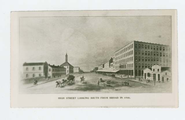
Photo: Henry Howe, Historical Collections of Ohio; Ohio Memory / Ohio History Connection, public domain · Wikimedia Commons
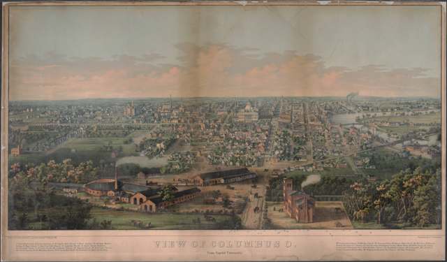
Photo: J. T. Palmatary, printed by E. Sachse & Co.; New York Public Library, public domain · Wikimedia Commons
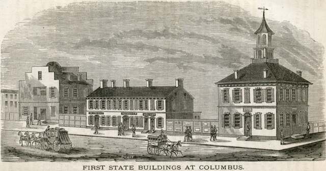
Photo: Columbus, Ohio: Its History, Resources, and Progress (1873); Columbus Metropolitan Library, public domain · Wikimedia Commons
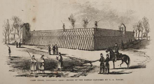
Photo: Frank Leslie's Illustrated Newspaper; Library of Congress Prints and Photographs Division, public domain · Wikimedia Commons
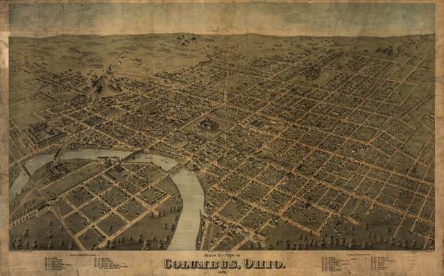
Photo: H. H. Bailey and O. H. Bailey, Fowler & Bailey; lithographed by Strobridge & Co.; Library of Congress, public domain · Wikimedia Commons
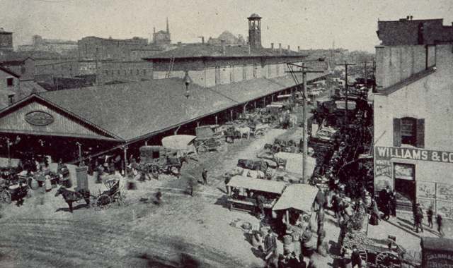
Photo: Baker Art Gallery; Columbus Metropolitan Library digital collections, no known copyright restrictions · Wikimedia Commons
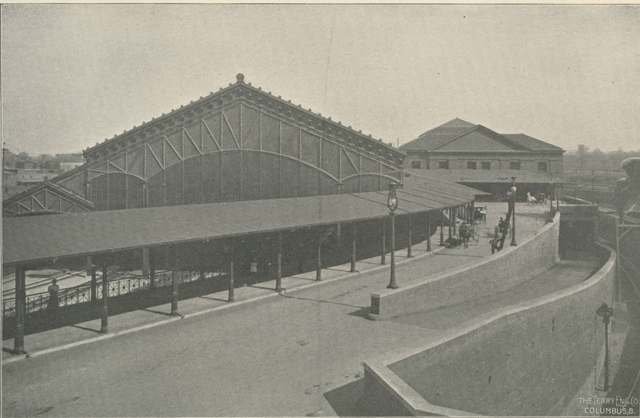
Photo: Baker Art Gallery, from The Story of Columbus: Past, Present and Future; Columbus Metropolitan Library, public domain · Wikimedia Commons
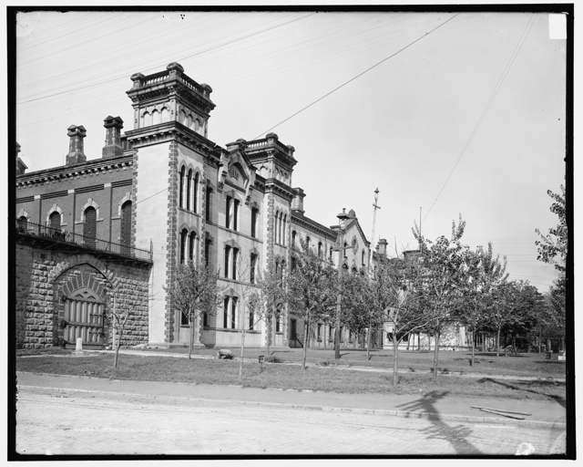
Photo: Detroit Publishing Co.; Library of Congress, public domain · Wikimedia Commons

Photo: Library of Congress, Prints and Photographs Division, public domain · Wikimedia Commons

Photo: Library of Congress, Panoramic Photographs collection, public domain · Wikimedia Commons
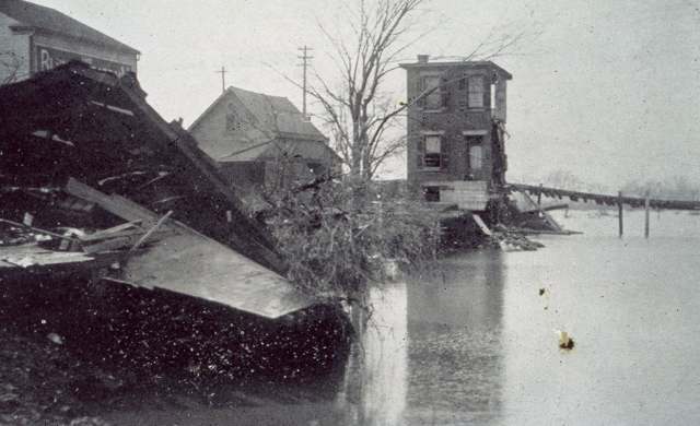
Photo: Columbus Metropolitan Library, contributed via the Digital Public Library of America and the Ohio Digital Network, public domain · Wikimedia Commons
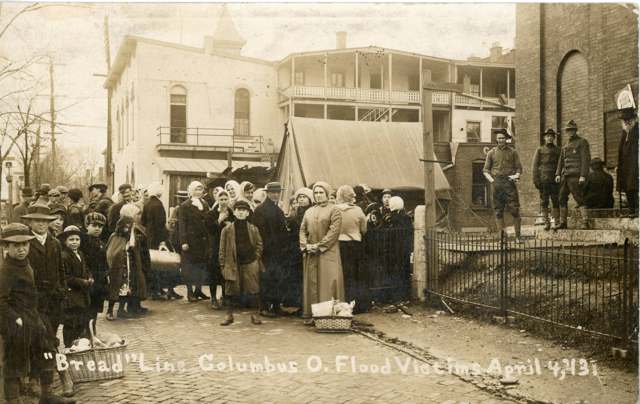
Photo: Columbus Metropolitan Library Digital Collection, public domain · Wikimedia Commons
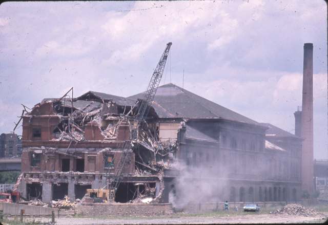
Photo: David Lucas; Columbus Metropolitan Library, no known copyright restrictions · Wikimedia Commons
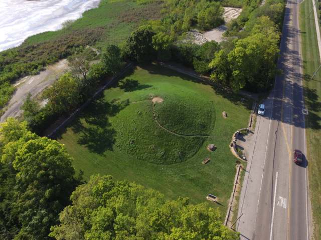
Photo: Kevin Payravi, CC BY-SA 4.0 · Wikimedia Commons
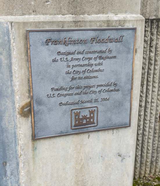
Photo: Wikimedia Commons user Ɱ, CC BY-SA 4.0 · Wikimedia Commons
Local history sources: en.wikipedia.org · en.wikipedia.org · en.wikipedia.org · en.wikipedia.org · en.wikipedia.org · en.wikipedia.org · en.wikipedia.org · en.wikipedia.org · en.wikipedia.org · en.wikipedia.org · en.wikipedia.org · en.wikipedia.org · en.wikipedia.org · en.wikipedia.org · en.wikipedia.org · en.wikipedia.org · en.wikipedia.org · en.wikipedia.org · en.wikipedia.org · en.wikipedia.org · en.wikipedia.org · en.wikipedia.org · en.wikipedia.org · en.wikipedia.org · en.wikipedia.org · en.wikipedia.org · en.wikipedia.org · en.wikipedia.org · en.wikipedia.org · en.wikipedia.org · en.wikipedia.org · en.wikipedia.org · en.wikipedia.org · en.wikipedia.org · archive.org · archive.org · archive.org · hmdb.org · hmdb.org · hmdb.org · hmdb.org · hmdb.org · hmdb.org · hmdb.org · hmdb.org · hmdb.org · hmdb.org · hmdb.org · dublinohiohistory.org · loc.gov · loc.gov · loc.gov · loc.gov · loc.gov · lccn.loc.gov · digital-collections.columbuslibrary.org · digital-collections.columbuslibrary.org · commons.wikimedia.org · commons.wikimedia.org · commons.wikimedia.org · commons.wikimedia.org · commons.wikimedia.org · commons.wikimedia.org · commons.wikimedia.org · commons.wikimedia.org · commons.wikimedia.org · commons.wikimedia.org · commons.wikimedia.org · commons.wikimedia.org · commons.wikimedia.org · commons.wikimedia.org · commons.wikimedia.org
Water
Scioto River intake at the plant on Dublin Rd, a few miles below Griggs Dam, opposite Marble Cliff The water here
- Columbus Public Water System89% of residentsScioto River (Griggs & O'Shaughnessy), Hoover Reservoir on Big Walnut Ck, plus wells
- Gahanna City2% of residentsScioto River (Griggs & O'Shaughnessy), Hoover Reservoir on Big Walnut Ck, plus wells
- Del-co Water Company, Inc.1% of residentsOlentangy River, O'Shaughnessy and Alum Creek reservoirs, plus Knox County wells
- Westerville City1% of residentsAlum Creek + wells
- Reynoldsburg City1% of residentsScioto River (Griggs & O'Shaughnessy), Hoover Reservoir on Big Walnut Ck, plus wells
- Bexley City1% of residentsScioto River (Griggs & O'Shaughnessy), Hoover Reservoir on Big Walnut Ck, plus wells
- Aqua Ohio - Blacklick1% of residentsGroundwater wells (3 wells)
- Sanitary District #41% of residentsScioto River (Griggs & O'Shaughnessy), Hoover Reservoir on Big Walnut Ck, plus wells
- Canal Winchester City0% of residentsLocal groundwater wells (Franklin Co.)
- Obetz Village0% of residentsGroundwater wells (2 wells)
- Aqua Ohio - Huber Ridge0% of residentsGroundwater wells (7 wells)
- Aqua Ohio - Lake Darby0% of residentsGroundwater wells (2 wells)
- Aqua Ohio - Worthington Hills0% of residentsGroundwater wells (3 wells)
- Fairfield County Utilities0% of residentsLocal groundwater wells (central Ohio, aquifer undocumented)
- Pickerington City0% of residentslocal buried-valley aquifer (wells near Diley Road)
- Groveport0% of residentsGroundwater wells (2 wells)
- Aqua Ohio - Timberbrook Pw0% of residentsGroundwater wells (2 wells)
- Licking Regional Water District0% of residentsRaccoon Creek Valley aquifer (local wells)
- Enchanted Acres MHP0% of residentsGroundwater wells (2 wells)
- Jefferson Water and Sewer District0% of residentsLocal groundwater wells (Blacklick/eastern Franklin Co.)
- Obetz Satellite 60% of residentsScioto River (Griggs & O'Shaughnessy), Hoover Reservoir on Big Walnut Ck, plus wells
- Obetz Satellite 20% of residentsScioto River (Griggs & O'Shaughnessy), Hoover Reservoir on Big Walnut Ck, plus wells
- Leonard Park0% of residentsScioto River (Griggs & O'Shaughnessy), Hoover Reservoir on Big Walnut Ck, plus wells
- Obetz Satellite 10% of residentsScioto River (Griggs & O'Shaughnessy), Hoover Reservoir on Big Walnut Ck, plus wells
- Oak Hills Mobile Home Park0% of residentsGroundwater wells (2 wells)
- Hayden Heights MHP0% of residentsGroundwater wells (2 wells)
- Greentree Mobile Home Park0% of residentsGroundwater wells (1 wells)
- Lithopolis Village0% of residentsGroundwater wells (3 wells)
- Caravan Village MHP0% of residentsGroundwater wells (2 wells)
- Monterey Care Center0% of residentsScioto River (Griggs & O'Shaughnessy), Hoover Reservoir on Big Walnut Ck, plus wells
- Country Side Mobile Home0% of residentsGroundwater wells
- Lockbourne Village0% of residentsScioto River (Griggs & O'Shaughnessy), Hoover Reservoir on Big Walnut Ck, plus wells
- Marysville City0% of residentsMill Creek via Marysville Reservoir (Raymond Rd) + wells
- Suburbans Community MHP0% of residentsGroundwater wells (2 wells)
Its ZIP codes
Each ZIP code that touches Columbus, with the share of its residents who live here and the same headline figures as the ZIP page.
The county
Franklin County: 45 ZIP codes, 42 cities, villages and townships, 1,356,733 people.
Nearby places
Cite this page
Cite this page as:
Cracked Buckeye (Open Shower Co), "Columbus, Franklin County", https://crackedbuckeye.com/place/columbus/, built 2026-09-16, accessed [date].
Machine-readable: /api/place/columbus.json (open JSON, CC BY 4.0 for the compilation; the underlying records keep their own terms) · How to cite · Report a correction · Built 2026-09-16