How Franklin Township, Franklin County began
Franklin Township was one of the four original townships laid out immediately after Franklin County's own formation in 1803, and the only one that still carries its original name. It contains the site of Franklinton, laid out on the west bank of the Scioto River by surveyor Lucas Sullivant in August 1797, the first permanent Euro-American settlement in the county and its seat of government from 1803 until 1824, now absorbed into Columbus. The township lost its western third to the new Prairie Township in 1819. During the Civil War, Camp Chase, a Union training camp and Confederate prisoner-of-war camp, stood on the National Road within the township; only its Confederate cemetery survives amid the houses that replaced it. Today Franklin Township is a scatter of small unincorporated islands mostly surrounded by Columbus, home to Green Lawn Abbey, Campbell (Shrum) Mound, and the grounds where the state's Central Ohio Lunatic Asylum once stood.
Settled 1797, platted 1797, incorporated 1803, by Lucas Sullivant surveyed and platted Franklinton in 1797; the township was organized in 1803 as one of Franklin County's original four townships, the same year the county itself was formed.
Where the name comes from
Franklin Township takes its name from Franklin County, formed in 1803 and divided at once into four townships; the 1880 county history notes it 'is the only township in the county that bears its original name,' the other three having since been renamed or subdivided. The county in turn was named for Benjamin Franklin.
Before the town
The 1880 county history, drawing on the recollection of early resident Nelson Foos, records that Wyandot people were the most numerous Native residents in the township during early settlement, with some Lenape (Delaware) and Mingo (Seneca-Cayuga) families as well. It places 'an extensive encampment... on the west bank of the Scioto river, not far from where now stands the Harrisburg bridge,' and says Native families had raised corn on river-bottom land that settlers came to call 'Sullivant's Prairie.' The same account, filtered through settler memory eight decades later, describes relations as generally peaceable and recounts that one man stayed behind after the rest left the area, living on game and settlers' charity until he was shot by a hunter. Franklin County lay south and east of the Greenville Treaty Line, so this land was ceded by the Wyandot, Lenape, Shawnee, Miami, Ottawa, and other signatory nations to the United States under the 1795 Treaty of Greenville, two years before Sullivant's survey. Far older evidence also survives: Campbell Mound (commonly called Shrum Mound), a conical burial mound raised by people of the Adena culture roughly 800 BC to AD 100, stands on a bluff above the Scioto at 3141 McKinley Avenue within the township and has never been archaeologically excavated. No further township-specific record of Adena, Hopewell, or Fort Ancient villages, or of named Wyandot/Lenape/Mingo towns or trails here, was found in the sources checked; broader county-level context will be in the Franklin County file.
Nations recorded here: Wyandot, Lenape (Delaware), Mingo (Seneca-Cayuga), Adena culture.
- Campbell Mound (Shrum Mound) (mound) — 3141 McKinley Avenue, Franklin Township/west Columbus, on a bluff above the Scioto River, Adena culture, roughly 800 BC – AD 100 (en.wikipedia.org)
- Scioto River encampment near the Harrisburg bridge (camp) — west bank of the Scioto River, Franklin Township, near the later Harrisburg bridge, pre-settlement through the early 1800s (archive.org)
Timeline
- — The Treaty of Greenville cedes most of what becomes Franklin County, lying south and east of the treaty line, to the United States, opening the Scioto valley to survey and settlement.
- — In August, surveyor Lucas Sullivant lays out the village of Franklinton on the west bank of the Scioto, the first permanent settlement in the county, naming it for the recently deceased Benjamin Franklin; he donates lots along 'Gift Street' to actual settlers to encourage the town's growth.
- — Joseph Dixon becomes the first settler family at 'the Forks of the Scioto,' as Franklinton was first known, according to early resident A. McElvain's account recorded eight decades later.
- — Franklin County is organized and divided into four original townships; Franklin Township is the only one that keeps its original name. Zachariah Stephen and James Marshall serve as its first justices of the peace, and Franklinton becomes the county seat, a role it holds until 1824. (Wikipedia's infobox instead gives 1804 as the township's organization date.)
- — A log schoolhouse operates on Gift Street in Franklinton, among the township's earliest schools; early pupil Mr. Foos later recalled a teacher whose drunken cruelty finally got him run off.
- — Prairie Township is created out of Franklin Township's western part, reducing Franklin to approximately its present limits.
- — Lucas Sullivant builds the township's first grist-mill of any size, on the Scioto; the property later becomes known as Rickley's Mill.
- — A 50-acre slate quarry tract on the Scioto River is purchased from William S. Sullivant; its stone, described as resembling clouded marble, is used to build the Ohio Statehouse and the state penitentiary.
- — Camp Chase, a Union training camp and later a Confederate prisoner-of-war camp, operates on the south side of the National Road about four miles west of Columbus; roughly 150,000 Union soldiers and 25,000 Confederate prisoners pass through it over the war.
- — On November 18, fire destroys the original state lunatic asylum building in Columbus; six female patients are suffocated in the smoke, and the fire is believed to have been set deliberately.
- — The state buys 300 acres from William S. Sullivant in Franklin Township, naming the site 'Glenwood,' for a replacement asylum; Governor Rutherford B. Hayes presides as the Masonic Grand Lodge lays the cornerstone on July 4.
- — In spring, a Friends (Quaker) meeting is organized at Camp Chase; members build a brick meetinghouse that summer where the National Road crosses the Cincinnati, Springfield & Columbus Railroad, at a cost of $1,300.
- — The new Central Ohio Lunatic Asylum, an immense building with roughly 1,000 rooms and nearly 100 miles of pipe for steam, water, and gas, is completed and opens to patients on August 13.
- — Campbell Mound (Shrum Mound) is listed on the National Register of Historic Places on November 10.
- — The Camp Chase site is listed on the National Register of Historic Places on April 11.
Stories
Gift Street and the founding of Franklinton
Early in 1797, Lucas Sullivant came into the Scioto country as a surveyor working the Virginia Military District, the tract set aside to pay Revolutionary War land bounties. That fall he laid out a village on the river's west bank and named it Franklinton, for Benjamin Franklin, who had died a few years before. To draw settlers to a raw frontier town, Sullivant gave away the lots along one street to anyone who would actually live on them; the street kept the name Gift Street ever after, and the inducement worked. The first families arrived that same fall and winter, among them Joseph Dixon, remembered as the very first, followed by George Skidmore, the Armstrong brothers, John Brickell, and others whose names the 1880 county history preserves. Sickness slowed the colony's early years, but by the War of 1812 Franklinton was, by local memory, at the height of its prosperity, and it served as Franklin County's seat of government until 1824, when the honor passed across the river to the new town of Columbus.
Camp Chase: rendezvous, prison, and forgetting
Camp Chase opened in May 1861 on leased ground beside the National Road, about four miles west of Columbus, named for Lincoln's Treasury secretary Salmon P. Chase. It trained Ohio volunteers bound for the war and, as the fighting wore on, held Confederate prisoners as well; over four years some 150,000 Union soldiers and 25,000 Confederate captives passed through its gate, and disease, especially a smallpox outbreak in the winter of 1863-64, killed hundreds of the prisoners. Writing only fifteen years after the camp closed, the county historian could already report that its grounds had been divided into house lots, the parade ground built over, with almost nothing left to mark 'the days of lang syne' except a decaying tavern called the Four Mile House. What did remain, and remains today, is the cemetery beside Sullivant Avenue holding 2,260 Confederate dead, tended still, unlike the mass graves at Andersonville the same writer was at pains to distinguish it from. The camp site was added to the National Register of Historic Places in 1973.
A fire, and the asylum on the hill
Ohio's first state lunatic asylum stood in Columbus proper, a quadrangular building of 440 rooms finished in 1847 at a cost of over $153,000, built in part by convict labor from the state penitentiary. On the night of November 18, 1868, fire tore through it; of 320 patients, all but six women, suffocated in one ward, were gotten out alive, and the county history records flatly that the blaze was believed set on purpose. The legislature voted money for a replacement, and in 1870 the state bought 300 acres from William S. Sullivant on a hill in Franklin Township overlooking the city, a site the matron named Glenwood for its wild beauty. Governor Rutherford B. Hayes presided as the Masonic Grand Lodge laid the cornerstone that Fourth of July. It took seven years and some 35 million bricks to finish: eight patient wings, a theater and chapel, and, notably for a water atlas, close to 100 miles of steam, water-supply, and gas piping running through the building. It opened to patients on August 13, 1877, as the Central Ohio Lunatic Asylum.
Campbell Mound, unopened for two thousand years
On a bluff above the Scioto River at what is now 3141 McKinley Avenue, people of the Adena culture raised a conical earthen mound sometime between about 800 BC and AD 100. Standing roughly 20 feet high and 100 feet across, it is known locally as Shrum Mound but carries the official name Campbell Mound on the National Register of Historic Places, which listed it in 1970. Unlike many Ohio mounds opened by nineteenth- and twentieth-century antiquarians, this one has never been archaeologically excavated, so what it holds, and who was buried there, remains unknown. The Ohio History Connection now manages the small park around it, called Campbell Memorial Park, where it stands as one of the few visible traces of the people who lived along the Scioto many centuries before Lucas Sullivant's survey crews arrived.
The schoolmaster on Gift Street
As early as 1805, a log schoolhouse stood on Gift Street in Franklinton, one of the township's first, and a boy named Foos, who grew up to help the 1880 county historian with much of what is known about early Franklin Township, was among its pupils. The teacher, an Irishman the account says was well educated, was also, in its words, 'cursed with an inordinate appetite for whiskey,' and drunk for most of each day. His preferred punishment was to make a child lay both palms flat on the desk, then draw a knife blade across the fingers deeply enough to cut. Word eventually reached the parents, and the man was, in the historian's relish, 'summarily kicked from the temple of learning.' It is a small, sharp story, but it is one of the few surviving glimpses of daily life, and its dangers, in the township's first permanent settlement.
Photographs
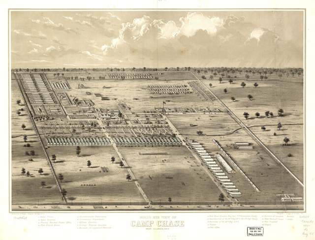
Photo: A. Ruger; Ehrgott, Forbriger & Co.; Library of Congress Geography and Map Division, public domain · Wikimedia Commons
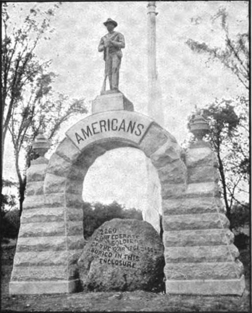
Photo: The Chautauquan, August 1902, p. 435, public domain · Wikimedia Commons
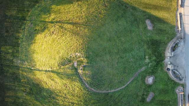
Photo: Jsjessee, via Flickr, CC BY-SA 2.0 · Wikimedia Commons
Local history sources: archive.org · en.wikipedia.org · en.wikipedia.org · en.wikipedia.org · en.wikipedia.org · en.wikipedia.org · commons.wikimedia.org · commons.wikimedia.org · commons.wikimedia.org · commons.wikimedia.org
Water
Scioto River intake at the plant on Dublin Rd, a few miles below Griggs Dam, opposite Marble Cliff The water here
- Columbus Public Water System98% of residentsScioto River (Griggs & O'Shaughnessy), Hoover Reservoir on Big Walnut Ck, plus wells
- Sanitary District #41% of residentsScioto River (Griggs & O'Shaughnessy), Hoover Reservoir on Big Walnut Ck, plus wells
- Aqua Ohio - Timberbrook Pw1% of residentsGroundwater wells (2 wells)
- Oak Hills Mobile Home Park0% of residentsGroundwater wells (2 wells)
- Monterey Care Center0% of residentsScioto River (Griggs & O'Shaughnessy), Hoover Reservoir on Big Walnut Ck, plus wells
Its ZIP codes
Each ZIP code that touches Franklin Township, Franklin County, with the share of its residents who live here and the same headline figures as the ZIP page.
The county
Franklin County: 45 ZIP codes, 42 cities, villages and townships, 1,356,733 people.
Nearby places
Cite this page
Cite this page as:
Cracked Buckeye (Open Shower Co), "Franklin Township, Franklin County", https://crackedbuckeye.com/place/franklin-township-franklin-county/, built 2026-09-16, accessed [date].
Machine-readable: /api/place/franklin-township-franklin-county.json (open JSON, CC BY 4.0 for the compilation; the underlying records keep their own terms) · How to cite · Report a correction · Built 2026-09-16