How Westerville began
Westerville grew up on Alum Creek in Blendon Township, first settled in 1806 by Connecticut families and named for the Westervelt family, Dutch settlers who arrived in 1818 and laid out the village in 1839. Otterbein University, which traces its founding to a Methodist seminary chartered that same year and refounded by the Church of the United Brethren in Christ in 1847, made the town an educational and religious center from the start. That religious character hardened into militant temperance: Westerville banned alcohol sales by local ordinance in 1859, defended the ban by force in the 1875-1879 "Whiskey War," and in 1909 became national headquarters of the Anti-Saloon League of America and its American Issue Publishing House, earning the nickname "Dry Capital of the World." Today it is a Columbus suburb of about 39,000, still centered on Otterbein and a restored nineteenth-century core, drawing its municipal water from the Alum Creek treatment plant the city opened in 1924.
Settled 1806, platted 1839, incorporated 1858, by Edward Phelps and Isaac Griswold families (1806 settlement, Blendon Township); Matthew Westervelt (platted the village, July 1839); incorporated by petition to the Franklin County commissioners.
Where the name comes from
Westerville takes its name from the Westervelt family — Peter, William and Matthew Westervelt, of Dutch descent from Duchess County, New York — who settled in Blendon Township in 1818 and became leading citizens. Matthew Westervelt laid out the village on his own land in July 1839 and donated twenty-five acres for the seminary that grew into Otterbein University, and the growing settlement took the family's name, with the spelling shortened from "Westervelt" to "Westerville." Both the 1880 county history and later sources confirm the family name as "Westervelt," not "Westerfield."
Before the town
No source found in this research documents a Native American village, camp, burial ground, or named trail specifically within Westerville's own footprint on Alum Creek. The fullest local account available, the 1880 county history's chapter on Blendon Township (the township Westerville grew up in), opens with a detailed physical description and the 1806 settlement story and records no Native place-name, village, or encounter on Alum Creek there. Its one Indigenous reference tied to this specific ground concerns a different stream: Big Walnut Creek, which also crosses the township east of Alum Creek near Central College and the later site of Westerville, was known to early settlers as the "Gahanna," or "Big Belly, the latter being the name of an Indian well known in the country," before a sawmill was built on it around 1814 — the source does not say which nation the man belonged to. More broadly, the same 1880 history's general county chapter describes a large Wyandot (Huron) town and cornfields at the site of Columbus, a few miles to the south, with the Wyandot the dominant nation in the immediate area into the early 1800s, ending in their 1842-1843 removal from Ohio; separately, sources on Alum Creek itself describe Lenape (Delaware) villages and travel along its course generally as it runs through Delaware and Franklin counties. But no source checked ties a named Wyandot or Lenape site to Westerville or Blendon Township specifically. The fuller county-level record of prehistoric cultures, historic nations, treaties and removal belongs in the Franklin County file, not here.
Nations recorded here: Wyandot, Lenape (Delaware).
- "Big Belly" / "Gahanna" name for Big Walnut Creek (other) — Big Walnut Creek near Central College and the later site of Westerville, Blendon Township, in local use by the time of the first settlers, before c. 1814 (archive.org)
Timeline
- — Edward Phelps and Isaac Griswold, with their families and Ethan Palmer, arrive from Windsor, Connecticut, and become the first settlers of what becomes Blendon Township, first camping on high ground east of Alum Creek.
- — The county commissioners organize the township as "Harrison" Township on March 6, with Garrit Sharp among its first trustees; it is renamed Blendon on December 8, 1824.
- — Peter, William and Matthew Westervelt, a Dutch-descended family from Duchess County, New York, settle in the township and become leading citizens; Westerville is later named for them.
- — Gideon Hart, who had come from Connecticut in 1816 to claim 380 acres awarded to his father for Revolutionary War service, builds the house on what is now Hempstead Road later known as the oldest surviving residence in Westerville.
- — The Ohio legislature charters the Blendon Young Men's Seminary at Westerville under Methodist auspices (February 9) — the school that becomes Otterbein University — and Matthew Westervelt lays out the village of Westerville in July, donating twenty-five acres for the school.
- — Trustees of the Church of the United Brethren in Christ, who had taken over the debt-burdened seminary the year before, hold their first meeting as Otterbein University's governing board on April 26 — the date still inscribed on the college building as its founding date; the state grants a full university charter in 1849.
- — Garrit Sharp builds the brick house on North State Street later known as the Alkire House, which he and his family use to shelter freedom seekers on the Underground Railroad.
- — The Franklin County commissioners grant Westerville's petition for incorporation on July 19; the first village election on October 11 chooses John Haywood as mayor.
- — Otterbein's main college building burns to the ground overnight on January 26, destroying a library of more than 3,000 volumes; a new building is completed in 1871. The same year, the present Central College Presbyterian Church building is finished east of Westerville.
- — Westerville, which had banned alcohol sales by local ordinance since 1859, sees Henry Corbin try to open its first saloon on July 1; church bells summon about 1,000 townspeople, and over the following weeks vigilantes destroy the saloon with repeated explosions — the start of the "Whiskey War."
- — Corbin reopens a saloon in the basement of the Clymer Hotel; vigilantes destroy it with two 26-pound kegs of gunpowder, and the Corbin family leaves for Columbus, ending the Whiskey War.
- — The Anti-Saloon League of America moves its national headquarters and printing operation, the American Issue Publishing Company, to Westerville; the new building is dedicated in October.
- — Westerville opens its Alum Creek water treatment plant on December 30, ending the city's reliance on private wells.
- — Westerville becomes the first community in Ohio to add fluoride to its public water supply.
- — The U.S. Army Corps of Engineers builds the flood-control Alum Creek Dam well upstream of Westerville, authorized under the 1962 Flood Control Act, creating Alum Creek Lake.
Stories
The Whiskey War of 1875
On July 1, 1875, Henry Corbin tried to open Westerville's first saloon at the southeast corner of West Main and Knox streets. The night before, vandals had broken in, dumped his whiskey and bored holes in his beer kegs, but Corbin restocked and was ready to open at 9 a.m. anyway. Church and fire bells across town rang out and summoned a crowd of about 1,000 residents, who met Corbin — reportedly holding a pistol in each hand — not with a riot but with hymn-singing and prayer before dispersing. It was vigilantes, working at night over the following weeks, who did the real damage: they bombed the saloon repeatedly, the last blast destroying much of the building. Corbin tried again in 1879, opening a basement saloon in the Clymer Hotel; vigilantes blew that one up too, with two 26-pound kegs of gunpowder, and the Corbins left Westerville for Columbus for good. The episode, still remembered locally as the Whiskey War, grew out of Westerville's strong United Brethren and Otterbein University-shaped temperance culture and an 1859 town ordinance already banning alcohol sales; a change in state law in early 1875 had opened a legal window for saloonkeepers like Corbin to try anyway.
Dry Capital of the World
The Anti-Saloon League of America was founded in Oberlin, Ohio, in 1893 and grew within a generation into the most effective single-issue pressure group in the country. In 1909 the citizens of Westerville offered the League a building site, and that October the League dedicated its new national headquarters and print shop there, incorporated as the American Issue Publishing Company. The plant ran presses around the clock with roughly 200 employees, and within three years was turning out about 250 million pages of tracts, papers and pledge cards a month — output that helped make Westerville, for a time, the smallest town in the country with its own first-class post office, since the League alone mailed more than 40 tons of literature monthly. Editor Ernest Cherrington oversaw the operation, including the six-volume Standard Encyclopedia of the Alcohol Problem published between 1924 and 1930. The League's lobbying helped deliver the congressional majorities behind the Eighteenth Amendment, ratified in 1919, and the town earned the nickname "Dry Capital of the World." The old headquarters building later became the Anti-Saloon League Museum & Library, run today by the Westerville Public Library.
Benjamin Hanby's Songs
Benjamin Russell Hanby was born in Rushville, Ohio, on July 22, 1833, the son of United Brethren bishop William Hanby, and moved with his family to Westerville, enrolling at Otterbein University in 1849 at age sixteen. While still a student, in 1856, he wrote "Darling Nelly Gray," an anti-slavery ballad based on the true story of Joseph Selby, a fugitive slave who reached the Hanby family's earlier home in Rushville and died there; the song became an international hit and is still performed today. After graduating in 1858, Hanby taught school, became a United Brethren minister, and kept composing — roughly eighty songs in all, including "Up on the Housetop" (1864), one of the first popular secular Christmas songs. He died of tuberculosis in Chicago on March 16, 1867, at thirty-three, and is buried in Otterbein Cemetery in Westerville. The family's Westerville home at 160 West Main Street, built in 1846 and occupied by the Hanbys from 1853 to 1870, was listed on the National Register of Historic Places in 1970 and is preserved as Hanby House, a museum run by the Westerville Historical Society; in 2011 the National Park Service recognized it as a site on the Network to Freedom for its own Underground Railroad connections.
A Seminary Becomes a University
Westerville's college began in 1839 as the Blendon Young Men's Seminary, chartered by the Ohio legislature under Methodist Episcopal sponsorship on land Matthew Westervelt donated. The school struggled after Ohio Wesleyan University opened in nearby Delaware and drew away students, leaving about $1,200 in debt. In 1846 Westerville residents proposed handing the property to the Church of the United Brethren in Christ, whose Scioto Conference accepted the offer that October at a meeting in Pickaway County; the new board of trustees, which included Bishop William Hanby, held its first meeting on April 26, 1847 — the date still carved into the college building as its founding date — and the state granted a full university charter in 1849. Disaster struck on the night of January 26, 1870: hours after a religious service ended and the building was locked up, fire broke out and burned the main college building to the ground, destroying a library of more than 3,000 volumes, including a facsimile of the Sinaitic manuscript presented by the Russian emperor. Losses were estimated at $50,000, only partly covered by $20,000 of insurance, but Westerville and Columbus residents raised funds to rebuild, and a new building — the one still inscribed "Otterbein University, Founded April 26, 1847" — opened in 1871.
The Sharp Family and the Underground Railroad
Garrit Sharp was among the earliest settlers of the ground that became Westerville, remembered locally as the founder of "Sharp's Settlement," and by 1815 he was one of the first trustees of the newly organized township. A Methodist, he donated land for the township's first Methodist church and, in 1849, built a brick house on North State Street — following plans from a builder's handbook — that doubled as a safehouse on the Underground Railroad, sheltering freedom seekers moving north. His sons, living nearby on State Street and Africa Road, are remembered as continuing the work on their own properties. That same year, Garrit Sharp and his son William sold a small plot on what is now West Lincoln Street to the Methodist Episcopal Church for a dollar, to use as a burying ground; Garrit and his wife, Anna Goodspeed Sharp, are buried there today. His 1849 house is preserved as the Alkire House, listed on the National Register of Historic Places in 1978, and Ohio historical markers at North State Street and Africa Road, and at the old Methodist cemetery, commemorate the family's role.
From Wells to Alum Creek
Into the early 1920s, Westerville households drew their drinking water from private wells, even as the town's population grew past what wells could safely supply. Working with the Ohio State Department of Health, the city's Water Division settled on Alum Creek, running along the town's west side, as the source for a proper municipal system, and on December 30, 1924, the new Alum Creek water treatment plant went into service, ending the reliance on wells. In 1951 Westerville became the first community in Ohio to add fluoride to its public water supply. Decades later and far upstream, the U.S. Army Corps of Engineers built a much larger flood-control structure, the Alum Creek Dam, under authority Congress granted in the 1962 Flood Control Act; construction ran from 1970 to 1974 and created Alum Creek Lake, a separate project from the city's own water-supply works. The Westerville History Museum marked the treatment plant's hundredth anniversary with an exhibit that opened in June 2024.
Photographs
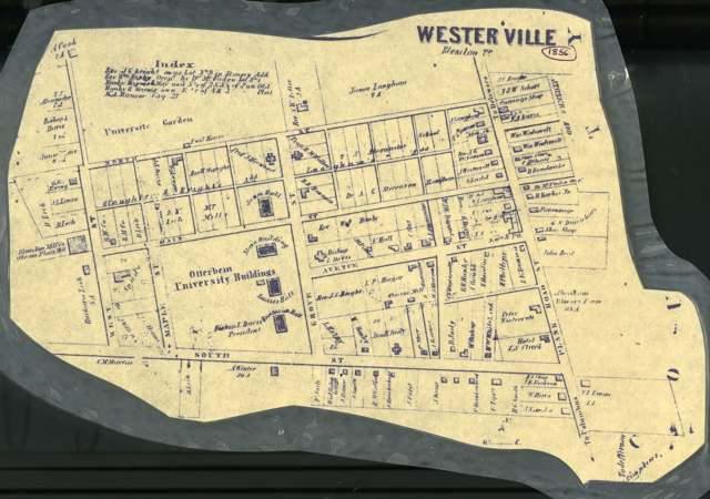
Photo: John Graham, Esq., via Columbus Metropolitan Library / Digital Public Library of America, public domain · Wikimedia Commons
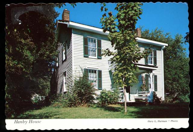
Photo: Columbus Metropolitan Library, via Digital Public Library of America, no known copyright restrictions · Wikimedia Commons
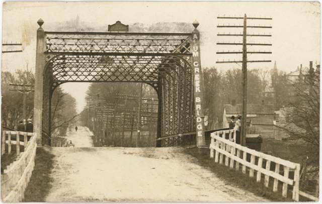
Photo: Columbus Metropolitan Library, via Digital Public Library of America, public domain · Wikimedia Commons
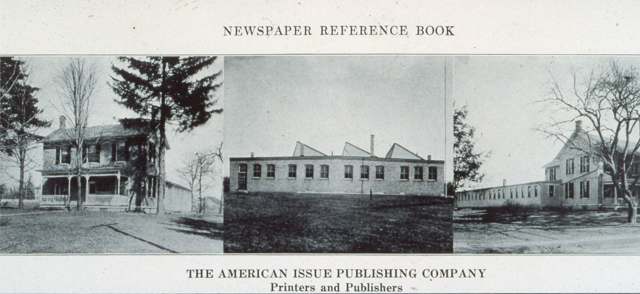
Photo: Columbus Metropolitan Library, via Digital Public Library of America, public domain · Wikimedia Commons
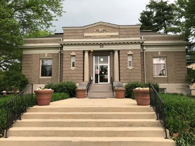
Photo: Mackinacbreezer, via Wikimedia Commons, CC BY-SA 4.0 · Wikimedia Commons
Local history sources: archive.org · en.wikipedia.org · westervillelibrary.org · en.wikipedia.org · en.wikipedia.org · westervillelibrary.org · en.wikipedia.org · saturdayeveningpost.com · en.wikipedia.org · en.wikipedia.org · en.wikipedia.org · en.wikipedia.org · en.wikipedia.org · westerville.org · commons.wikimedia.org · remarkableohio.org · remarkableohio.org · prohibition.osu.edu · en.wikipedia.org · commons.wikimedia.org · commons.wikimedia.org · commons.wikimedia.org · commons.wikimedia.org · commons.wikimedia.org
Water
Alum Creek, drawn just north of Main Street at the treatment plant, supplemented by 3 active groundwater wells The water here
- Westerville City42% of residentsAlum Creek + wells
- Columbus Public Water System31% of residentsScioto River (Griggs & O'Shaughnessy), Hoover Reservoir on Big Walnut Ck, plus wells
- Del-co Water Company, Inc.18% of residentsOlentangy River, O'Shaughnessy and Alum Creek reservoirs, plus Knox County wells
- Aqua Ohio - Huber Ridge8% of residentsGroundwater wells (7 wells)
Its ZIP codes
Each ZIP code that touches Westerville, with the share of its residents who live here and the same headline figures as the ZIP page.
| ZIP | Share | Water | Radon | Home value | Schools | Flood |
|---|---|---|---|---|---|---|
| 43081 Westerville | 47% | Alum Creek, drawn just north of Main Street at the treatment plant, supplemented by 3 active groundwater wells | 5.4 pCi/L average radon | Median year built 1986 | Westerville City · 3.5 stars overall | 1.5% of residents in the 1% floodplain |
| 43082 Genoa Township and Westerville | 28% | Alum Creek Reservoir intake at the Scott plant, Lewis Center Rd at Africa, Orange Township | 6.0 pCi/L average radon | Parcel list only | Westerville City · 3.5 stars overall | 0.5% of residents in the 1% floodplain |
The county
Franklin County: 45 ZIP codes, 42 cities, villages and townships, 1,356,733 people.
Nearby places
Cite this page
Cite this page as:
Cracked Buckeye (Open Shower Co), "Westerville, Franklin County", https://crackedbuckeye.com/place/westerville/, built 2026-09-16, accessed [date].
Machine-readable: /api/place/westerville.json (open JSON, CC BY 4.0 for the compilation; the underlying records keep their own terms) · How to cite · Report a correction · Built 2026-09-16