Upper Arlington
City · Franklin County · 36,793 residents · 2.5% municipal income tax
Local events in Upper Arlington
226 events in the next 90 days from 4 public calendars. All local events in Upper Arlington
Checked October 20; the events page is refreshed daily.
Deep dives about Upper Arlington
Long reads built from maps, newspapers and public records. All deep dives
Notable people from Upper Arlington
Ohioans tied to this place, each with a sourced profile. All notable Ohioans

How Upper Arlington began
Upper Arlington began on Christmas Eve 1913, when Columbus real-estate brothers King and Ben Thompson agreed to buy 840 acres of James T. Miller's farm on the Scioto River and lay it out as a curving, restricted 'garden suburb' modeled on Kansas City's Country Club District. The land had passed through a line of Perry Township owners — Backus, McCoy, Smith, and finally Miller — after an 1800 federal land-bounty grant, and it lies a short distance north of Shrum Mound, a roughly 2,000-year-old Adena burial mound that is the oldest recorded human trace in the immediate area. Development had barely started when, in 1916, the U.S. Army and Ohio National Guard turned the still-empty tract into Camp Willis, a mobilization camp for the Mexican border crisis. By 1917 the subdivision was known as Upper Arlington, after Arlington, its neighbor to the south (renamed Marble Cliff in 1901); it incorporated as a village on March 20, 1918, and became a city on February 8, 1941. It is now a fully built-out, largely residential Columbus suburb of roughly 36,800 people, known for its curvilinear streets and its Old Arlington Historic District.
Settled 1913, platted 1914, incorporated 1918, by King Gibson Thompson and Benjamin Sells Thompson (King and Ben Thompson).
Where the name comes from
The Thompsons first marketed their new subdivision as the 'Country Club District.' By 1917 it was known instead as 'Upper Arlington' — 'Arlington' for the neighboring village immediately to its south on the Scioto River, which had briefly carried that name before incorporating in 1901 as Marble Cliff, and 'Upper' for Upper Arlington's position north/upstream of it.
Before the town
Upper Arlington's own recorded Native history is thin, and what exists points just south of the modern city rather than to a site inside it. Adena people were building mounds along this stretch of the Scioto by roughly 800 BC; the nearest surviving example is Shrum Mound, a 20-foot conical burial mound on a bluff above the river in what is now Columbus's Campbell Memorial Park, just south of Upper Arlington. It was raised about 2,000 years ago, has never been excavated, and was added to the National Register of Historic Places on November 10, 1970, under its official listing name, Campbell Mound; the Shrum family, for whom it is popularly known, deeded the mound and the surrounding acre to the Ohio Historical Society in 1928. Franklin County once held an estimated 132 mounds and 28 earthworks, by an early count from the Ohio Historical Society's own curator of archaeology; only a handful survive, Shrum Mound among them. Upper Arlington's city history states that Wyandot people later hunted and, by the early 1700s, farmed this part of the Scioto valley, and that they were displaced after the United States issued Revolutionary War land-bounty grants covering the area around 1800; Wikipedia's account of the city agrees on both points. No source we found names a specific Wyandot village, trail, or treaty boundary as lying within Upper Arlington itself — the nearest documented Wyandot association in the immediate area is upriver at Dublin, where John Sells settled in 1808 and where Chief Leatherlips is memorialized. The Scioto's limestone bluffs continue along Upper Arlington's western edge (later dammed to form Griggs Reservoir) and downstream past the old quarry works near present Marble Cliff described in the 1880 county history; high ground of this kind was generally preferred for travel and settlement along central Ohio's rivers, but no specific Native trail or camp is recorded by name inside the city in the sources reviewed.
Nations recorded here: Adena culture, Wyandot.
- Shrum Mound (mound) — Campbell Memorial Park, 3141 McKinley Ave., Columbus, just south of Upper Arlington on a bluff above the Scioto River; listed on the National Register of Historic Places under the name Campbell Mound, Adena culture, roughly 800 BC - AD 100 (ohiohistory.org)
Timeline
- — Adena people build the conical burial mound known today as Shrum Mound, on a Scioto River bluff just south of the future Upper Arlington.
- — The United States issues Revolutionary War land-bounty grants covering this stretch of the Scioto valley to Elijah Backus, Jonathan Dayton, and Andrew Marker; Wyandot residents are displaced from the area in the years that follow.
- — John McCoy buys 1,157 acres of the Backus tract along the Scioto River; the land passes to Benjamin Smith and then, in 1859, to Dr. Henry Miller, whose family farms it until 1913.
- — Griggs Dam is completed on the Scioto River, forming Griggs Reservoir along what becomes Upper Arlington's western edge and giving Columbus its first major drinking-water reservoir; a separate Columbus water-system timeline instead dates the reservoir and its Scioto River Purification Plant to 1908.
- — On Christmas Eve, King Gibson Thompson and his brother Ben Thompson agree to buy 840 acres of James T. Miller's farm, the land that becomes Upper Arlington.
- — The Thompsons form the King Thompson Company and lay the farm out in roughly 2,500 lots along curving streets, marketing it first as the 'Country Club District.'
- — In August, grading begins on Roxbury Road, Upper Arlington's first street.
- — The undeveloped part of the new subdivision becomes Camp Willis, a mobilization camp where the Ohio National Guard trains before deploying to the Mexican border; it is named for Ohio Governor Frank B. Willis.
- — By this year the subdivision is known as 'Upper Arlington,' after Arlington, its neighbor to the south (renamed Marble Cliff in 1901); a first, informal school also opens in the basement of the Thompson home with twelve pupils.
- — On March 20, Upper Arlington incorporates as a village, population about 200.
- — In October, Upper Arlington's first public school opens with fifty-two students and four teachers, including Mary Boyer, who had been running a private kindergarten for the community.
- — Minnie R. Shrum deeds Shrum Mound and the surrounding acre to the Ohio Historical Society; the mound is listed on the National Register of Historic Places as Campbell Mound on November 10, 1970.
- — Upper Arlington becomes a city on February 8.
- — In October, the 536-acre Old Arlington neighborhood, with about 1,120 buildings, is listed on the National Register of Historic Places as the Upper Arlington Historic District.
- — The Frederick G. Kilgour House at 1415 Kirkley Road — home of the Upper Arlington resident who founded OCLC, the library consortium behind WorldCat — is added to the National Register of Historic Places.
Stories
The Thompson Brothers Build a Garden Suburb
King Gibson Thompson and his younger brother, Benjamin Sells Thompson, grew up in Georgetown, Ohio, on the Ohio River, and both attended Ohio State University before going into real estate together in Columbus. By 1913 they had a specific model in mind: Kansas City's Country Club District, an upscale, curving, deed-restricted development that was reshaping how American suburbs were built. On Christmas Eve 1913 they agreed to buy 840 acres of James T. Miller's farm, land roughly bounded today by Fifth Avenue, Riverside Drive, Lane Avenue, and Northwest Boulevard, with Miller's own physician, Dr. J. A. Van Fossen, helping broker the sale. The King Thompson Company, formed in 1914, laid the farm out in about 2,500 lots along winding streets rather than a grid, and crews graded Roxbury Road, the first of them, in August of that year. By 1915 six houses stood on the new streets, and early in 1916 King and Ben each finished building their own homes overlooking Miller Park. The brothers ran the development personally for decades afterward, controlling architecture and landscaping street by street, a level of hands-on control still visible in Old Arlington's uniform, mature streetscape today.
Camp Willis, 1916
The Thompsons' new suburb had produced barely half a dozen houses when, in 1916, its still-mostly-empty land was taken over for a very different purpose. The Ohio National Guard mobilized that year for duty on the Mexican border, and the open ground of the young Upper Arlington subdivision, between roughly Fifth Avenue and Lane Avenue, was chosen as a mustering and training ground. The resulting camp was named Camp Willis, after Ohio's sitting governor, Frank B. Willis. Guardsmen drilled, ate out of mess kits, and had their artillery batteries photographed on ground that, within a few years, would be residential streets and yards. The camp was gone well before Upper Arlington incorporated as a village in 1918, but it left a lasting mark on local memory: a boulder marker on Arlington Avenue near Tremont Road, close to where Jones Middle School now stands, and Upper Arlington's present-day Veterans Plaza both commemorate the site.
Shrum Mound, Just South of the City
Long before any farm or suburb, Adena people were raising burial mounds along the Scioto River valley, and the best-preserved example near Upper Arlington still stands just south of the city, on a bluff above the river in what is now Columbus's Campbell Memorial Park. Built roughly 2,000 years ago, the mound is about 20 feet high and 100 feet across, and it has never been excavated, so no one knows what, if anything, remains inside it. It is popularly called Shrum Mound for the family that owned the surrounding land in the early twentieth century: in 1928 Minnie R. Shrum deeded the mound and an acre around it to the Ohio Historical Society, which dedicated the site as a park the following year and still manages it as a public site today. It was formally added to the National Register of Historic Places on November 10, 1970, under the listing name Campbell Mound, after the park itself, which is named for former Ohio governor James E. Campbell. Franklin County once held well over a hundred mounds and dozens of earthworks, by one early count from the Ohio Historical Society's own curator of archaeology; nearly all have since been leveled by farming and development, which makes Shrum Mound one of only a handful that survive to be seen today.
Farms on the Scioto Before the Suburb
Upper Arlington's ground has a documented owner list stretching back to 1800, when the United States issued Revolutionary War land-bounty grants covering this stretch of the Scioto valley to Elijah Backus, Jonathan Dayton, and Andrew Marker. In 1818, John McCoy bought 1,157 acres of the Backus tract; the land later passed to Benjamin Smith and then, in 1859, to Dr. Henry Miller, whose family farmed it until his son James sold 840 acres of it to King and Ben Thompson in 1913. A few miles upriver, the Scioto valley's most prominent early landowner was John Sells, who settled at Dublin on the river's west bank in 1808; his daughter, Matilda Sells, married Samuel S. Davis of Perry Township in 1825, and the stone house Davis built that year on the Scioto's east bank, about a mile south of the Dublin bridge, still stands today and is separately listed on the National Register of Historic Places. Perry Township's 1880 county history records this same stretch of river bluffs as home to a stone quarry and to the old Backus and McCoy mills, later called the Marble Cliff mills, and notes, in the language of the period, that the cliffs 'abounded in rattlesnakes at an early day.' None of this farm-and-mill landscape survives inside Upper Arlington itself, but it is the ground the Thompson brothers bought in 1913.
Old Arlington Becomes a Historic District
By the early 1980s, the Thompsons' original curving streets and Tudor and Colonial Revival houses had become historic in their own right, and in 1983 the trustees of the Upper Arlington Historical Society began exploring a National Register nomination for the old subdivision. Volunteers spent roughly a year and a half inventorying and photographing buildings across the original tract before the nomination was complete. In October 1985 the district was listed on the National Register of Historic Places as the Upper Arlington Historic District, a 536-acre area encompassing about 1,120 buildings, more than 900 of them counted as contributing to its historic character. The nomination recognized it as one of the Columbus area's first planned communities of its kind, organized around parks, a school, a civic center, and shopping facilities rather than a plain street grid, at a time when Columbus itself had fewer than 250,000 people. Stone entrance piers, including the original one at Fifth Avenue and Cambridge Boulevard that already appears in 1918 photographs of the subdivision's entrance, still mark the district today.
Photographs
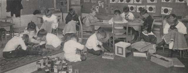
Photo: UA Archives / Upper Arlington Public Library, via Flickr Commons, no known copyright restrictions · Wikimedia Commons
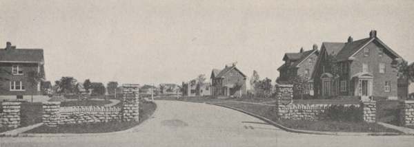
Photo: Upper Arlington Community (Ohio); scan via UA Archives, public domain · Wikimedia Commons
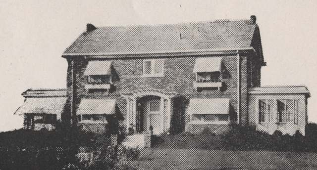
Photo: UA Archives / Upper Arlington History, via Flickr Commons, no known copyright restrictions · Wikimedia Commons
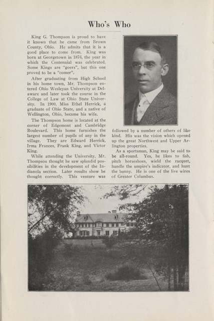
Photo: Upper Arlington Community (Ohio); scan via UA Archives, public domain · Wikimedia Commons
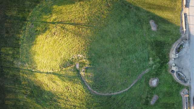
Photo: Photo by Flickr user Jsjessee, CC BY-SA 2.0 · Wikimedia Commons
Local history sources: en.wikipedia.org · ohiohistory.org · en.wikipedia.org · upperarlingtonoh.gov · upperarlingtonoh.gov · upperarlingtonoh.gov · en.wikipedia.org · ohiogenealogyexpress.com · genealogybug.net · commons.wikimedia.org · uahistory.org · uahistory.org · uahistory.org · en.wikipedia.org · upperarlingtonneighborhood.org · devcolumbusneighborhoods.osu.edu · columbusneighborhoods.org · ohiohistory.org · en.wikipedia.org · en.wikipedia.org · en.wikipedia.org · en.wikipedia.org · commons.wikimedia.org · commons.wikimedia.org · commons.wikimedia.org · commons.wikimedia.org · commons.wikimedia.org
Historic places
1 place in Upper Arlington on the National Register of Historic Places. Press a pin or a name for its whole record.
-
Kilgour, Frederick G., HouseBuilding · Upper Arlington · listed 2012
- Address
- 1415 Kirkley Rd.
- Where
- Upper Arlington, Franklin County · ZIP 43221
- What it is
- Building
- Listed on the National Register
- 2012
- NRIS reference number
- 12000392
- Coordinates
- 40.01975, -83.05004
National Register file (NPS) ↗ Search Wikipedia ↗ Street map and directions ↗ On the Cracked Buckeye map
Source: National Park Service, National Register of Historic Places point file. The listing year is shown where NPS's certification date agrees with the listing's reference number. Listing recognizes significance; it does not restrict a private owner.
Water
Big Walnut Creek at the plant's low-head dam and screen house on Morse Rd, below Hoover Dam The water here
- Columbus Public Water System100% of residentsScioto River (Griggs & O'Shaughnessy), Hoover Reservoir on Big Walnut Ck, plus wells
Hospitals, fire stations and more
Inside Upper Arlington's boundary: 2 nursing homes, 2 fire and EMS stations, 10 public schools, 3 private schools, 3 libraries, 2 museums, 1 police station, 10 public charging sites, 4 stations and terminals and 8 spill cases. Press a pin or a name for its whole record and its source.
Nursing homes (2)
-
First Community Village Healthcare Ctr4 of 5 stars · Columbus
- Address
- 1800 Riverside Drive, Columbus, OH 43212
- Certified beds
- 47
- Residents on an average day
- 38
- Medicare overall rating
- 4 of 5 stars
- Health inspections
- 3 of 5 stars
- Staffing
- 4 of 5 stars
- Quality measures
- 5 of 5 stars
- Penalties since 2023
- 1 fine totalling $17,610 (latest 2025-06-23)
- Ownership
- Non profit - Corporation
- Continuing care retirement community
- Yes
- Takes
- Medicare and Medicaid
- Phone
- (614) 486-9511
- Medicare ID
- 365047
Medicare Care Compare ↗ CMS nursing home data (source) ↗ Street map and directions ↗
-
Sapphire Rehabilitation and Care Center Special focus1 of 5 stars · Columbus
- Address
- 1605 Northwest Professional Plaza, Columbus, OH 43220
- Certified beds
- 113
- Residents on an average day
- 96
- Medicare overall rating
- 1 of 5 stars
- Health inspections
- 1 of 5 stars
- Staffing
- 1 of 5 stars
- Quality measures
- 4 of 5 stars
- Penalties since 2023
- 2 fines totalling $337,273, 2 payment denials (latest 2025-09-11)
- Special focus facility
- SFF Candidate
- Ownership
- For profit - Corporation
- Chain
- DAVID OBERLANDER
- Takes
- Medicare and Medicaid
- Phone
- (614) 451-5677
- Medicare ID
- 365950
Medicare Care Compare ↗ CMS nursing home data (source) ↗ Street map and directions ↗
Source: CMS Care Compare nursing home provider and penalties files; Medicare star ratings run 1 to 5.
Fire and EMS stations (2)
-
Upper Arlington Fire Division Station 71Upper Arlington
- Address
- 2095 Arlington Avenue, Upper Arlington, OH 43221
- Coordinates
- 39.99880, -83.06200
USGS National Map structures (source) ↗ Street map and directions ↗
-
Upper Arlington Fire Division Station 72Upper Arlington
- Address
- 3861 Reed Road, Upper Arlington, OH 43220
- Coordinates
- 40.03545, -83.06718
USGS National Map structures (source) ↗ Street map and directions ↗
Source: USGS National Map structures (most Ohio records last updated 2019 to 2022), checked against the Columbus and Cleveland station lists. The department that answers a call is set by jurisdiction and mutual aid, not by distance.
Public schools (10)
-
Barrington Road Elementary School4.5 of 5 stars · Upper Arlington
- Address
- 1780 Barrington Rd, Upper Arlington, OH 43221
- School district
- Upper Arlington City School District
- Kind (NCES)
- Regular School
- Students, 2023-24
- 778
- Teachers (full-time equivalent)
- 46.65
- Report card, 2025-26
- 4.5 of 5 stars
- Performance index
- 96.8%
- Ohio building IRN
- 001644
- NCES school ID
- 390449301859
NCES school record ↗ Ohio School Report Card ↗ Street map and directions ↗
-
Burbank Early Childhood SchoolUpper
- Address
- 4770 Burbank Dr, Upper, OH 43220
- Kind (NCES)
- Regular School
- Students, 2023-24
- 244
- Teachers (full-time equivalent)
- 19
- NCES school ID
- 390449305970
-
Greensview Elementary School5 of 5 stars · Upper Arlington
- Address
- 4301 Greensview Dr, Upper Arlington, OH 43220
- School district
- Upper Arlington City School District
- Kind (NCES)
- Regular School
- Students, 2023-24
- 489
- Teachers (full-time equivalent)
- 29.4
- Report card, 2025-26
- 5 of 5 stars
- Performance index
- 98.1%
- Ohio building IRN
- 014597
- NCES school ID
- 390449301862
NCES school record ↗ Ohio School Report Card ↗ Street map and directions ↗
-
Hastings Middle School4.5 of 5 stars · Upper Arlington
- Address
- 1850 Hastings Ln, Upper Arlington, OH 43220
- School district
- Upper Arlington City School District
- Kind (NCES)
- Regular School
- Students, 2023-24
- 720
- Teachers (full-time equivalent)
- 32.49
- Report card, 2025-26
- 4.5 of 5 stars
- Performance index
- 91.4%
- Ohio building IRN
- 015602
- NCES school ID
- 390449301863
NCES school record ↗ Ohio School Report Card ↗ Street map and directions ↗
-
Jones Middle School5 of 5 stars · Upper Arlington
- Address
- 2100 Arlington Ave, Upper Arlington, OH 43221
- School district
- Upper Arlington City School District
- Kind (NCES)
- Regular School
- Students, 2023-24
- 750
- Teachers (full-time equivalent)
- 53
- Report card, 2025-26
- 5 of 5 stars
- Performance index
- 91.6%
- Ohio building IRN
- 018531
- NCES school ID
- 390449301864
NCES school record ↗ Ohio School Report Card ↗ Street map and directions ↗
-
Tremont Elementary School4.5 of 5 stars · Upper Arlington
- Address
- 2900 Tremont Rd, Upper Arlington, OH 43221
- School district
- Upper Arlington City School District
- Kind (NCES)
- Regular School
- Students, 2023-24
- 700
- Teachers (full-time equivalent)
- 37.8
- Report card, 2025-26
- 4.5 of 5 stars
- Performance index
- 92%
- Ohio building IRN
- 037465
- NCES school ID
- 390449301865
NCES school record ↗ Ohio School Report Card ↗ Street map and directions ↗
-
Upper Arlington High School5 of 5 stars · Upper Arlington
- Address
- 1625 Zollinger Rd, Upper Arlington, OH 43221
- School district
- Upper Arlington City School District
- Kind (NCES)
- Regular School
- Students, 2023-24
- 1,895
- Teachers (full-time equivalent)
- 86.49
- Report card, 2025-26
- 5 of 5 stars
- Performance index
- 96.6%
- Four-year graduation rate
- 98.1%
- Ohio building IRN
- 037945
- NCES school ID
- 390449301866
NCES school record ↗ Ohio School Report Card ↗ Street map and directions ↗
-
Upper Arlington Online Academy3 of 5 stars · Upper Arlington
- Address
- 1950 N Mallway Dr, Upper Arlington, OH 43221
- School district
- Upper Arlington City School District
- Kind (NCES)
- Regular School
- Students, 2023-24
- 57
- Teachers (full-time equivalent)
- 3.96
- Report card, 2025-26
- 3 of 5 stars
- Performance index
- 73.7%
- Four-year graduation rate
- 81.8%
- Ohio building IRN
- 019643
- NCES school ID
- 390449306078
NCES school record ↗ Ohio School Report Card ↗ Street map and directions ↗
-
Wickliffe Elementary School3.5 of 5 stars · Upper Arlington
- Address
- 2405 Wickliffe Rd, Upper Arlington, OH 43221
- School district
- Upper Arlington City School District
- Kind (NCES)
- Regular School
- Students, 2023-24
- 493
- Teachers (full-time equivalent)
- 27.95
- Report card, 2025-26
- 3.5 of 5 stars
- Performance index
- 84.6%
- Ohio building IRN
- 041194
- NCES school ID
- 390449305751
NCES school record ↗ Ohio School Report Card ↗ Street map and directions ↗
-
Windermere Elementary School5 of 5 stars · Upper Arlington
- Address
- 4101 Windermere Rd, Upper Arlington, OH 43220
- School district
- Upper Arlington City School District
- Kind (NCES)
- Regular School
- Students, 2023-24
- 532
- Teachers (full-time equivalent)
- 20.34
- Report card, 2025-26
- 5 of 5 stars
- Performance index
- 98.2%
- Ohio building IRN
- 041715
- NCES school ID
- 390449301868
NCES school record ↗ Ohio School Report Card ↗ Street map and directions ↗
Source: NCES EDGE public school locations 2024-25 and Common Core of Data 2023-24 (type, students, teachers); Ohio School Report Cards 2025-26 (Department of Education and Workforce), matched by name within the district.
Private schools (3)
-
Mountview Christian Preschool & KindergartenPrivate, religious, independent · Columbus
- Address
- 2140 Fishinger Rd, Columbus, OH 43221
- Kind
- religious, independent
- Students, 2023-24
- 8
- Teachers (full-time equivalent)
- 1
- Students per teacher
- 8
- Phone
- (614) 451-8691
- NCES private school ID
- A9707673
-
St Agatha SchoolPrivate, Catholic · Columbus
- Address
- 1880 Northam Rd, Columbus, OH 43221
- Kind
- Catholic
- Students, 2023-24
- 185
- Teachers (full-time equivalent)
- 13
- Students per teacher
- 14.2308
- Phone
- (614) 488-9000
- NCES private school ID
- 01059993
-
St Andrew SchoolPrivate, Catholic · Columbus
- Address
- 4081 Reed Rd, Columbus, OH 43220
- Kind
- Catholic
- Students, 2023-24
- 436
- Teachers (full-time equivalent)
- 33
- Students per teacher
- 13.2121
- Phone
- (614) 451-1626
- NCES private school ID
- A2370962
Source: NCES Private School Survey 2023-24.
Public libraries (3)
-
Lane Road BranchBranch · Upper Arlington
- Address
- 1945 Lane Road, Upper Arlington, OH 43220
- What it is
- Branch
- Library system
- Upper Arlington Public Library
- Open
- 3,120 hours a year, 52 weeks
- Building
- 10,205 sq ft
- System's visits, FY2024
- 470,340
- System's loans, FY2024
- 1,499,017
- People the system serves
- 36,298
- Phone
- (614) 459-0273
IMLS Public Libraries Survey (source) ↗ Street map and directions ↗
-
Miller Park BranchBranch · Upper Arlington
- Address
- 1901 Arlington Ave., Upper Arlington, OH 43212
- What it is
- Branch
- Library system
- Upper Arlington Public Library
- Open
- 3,120 hours a year, 52 weeks
- Building
- 4,396 sq ft
- System's visits, FY2024
- 470,340
- System's loans, FY2024
- 1,499,017
- People the system serves
- 36,298
- Phone
- (614) 488-5710
IMLS Public Libraries Survey (source) ↗ Street map and directions ↗
-
Upper Arlington Public LibraryCentral library · Upper Arlington
- Address
- 2800 Tremont Rd., Upper Arlington, OH 43221
- What it is
- Central library
- Library system
- Upper Arlington Public Library
- Open
- 3,120 hours a year, 52 weeks
- Building
- 60,517 sq ft
- System's visits, FY2024
- 470,340
- System's loans, FY2024
- 1,499,017
- People the system serves
- 36,298
- Phone
- (614) 486-9621
IMLS Public Libraries Survey (source) ↗ Street map and directions ↗
Source: IMLS Public Libraries Survey FY2024 (outlets and their systems). Any Ohio resident can get a free card at any Ohio public library.
Museums, historical societies, gardens and zoos (2)
-
Ohio To Erie Trail FundHistorical society · Columbus
- What it is
- Historical society
- City
- Columbus
- Coordinates
- 40.05123, -83.06697
Search Wikipedia ↗ IMLS Museum Data Files (source) ↗ Street map and directions ↗
The museum list is IMLS's 2018 file; a museum may have closed or moved since.
-
Upper Arlington Historical SocietyHistorical society · Upper Arlington
- What it is
- Historical society
- City
- Upper Arlington
- Coordinates
- 40.01376, -83.06539
Search Wikipedia ↗ IMLS Museum Data Files (source) ↗ Street map and directions ↗
The museum list is IMLS's 2018 file; a museum may have closed or moved since.
Source: IMLS Museum Data Files, 2018.
Police stations (1)
-
Upper Arlington Police DepartmentUpper Arlington
- Address
- 3600 Tremont Road, Upper Arlington, OH 43221
- Coordinates
- 40.03113, -83.05097
USGS National Map structures (source) ↗ Street map and directions ↗
Source: USGS National Map structures, police stations, corrected and completed by hand (September 2026). The department that answers a call is set by jurisdiction, not by distance.
Public EV charging (10)
-
3360TREMONTROAD EYESEVC@5POINTS2 Level 2 · Upper Arlington
- Address
- 3360 Tremont Rd, Upper Arlington, OH 43221
- Ports
- 2 Level 2
- Plugs
- J1772
- Network
- ChargePoint Network
- Hours
- 24 hours daily
- Phone
- 888-758-4389
Station Locator (NREL) ↗ Alternative Fuels Data Center (source) ↗ Street map and directions ↗
-
CITY OF UA MSC TREMONT RD2 DC fast2 DC fast · Upper Arlington
- Address
- 3600 Tremont Road, Upper Arlington, OH 43221
- Ports
- 2 DC fast
- Plugs
- CCS, CHAdeMO
- Network
- ChargePoint Network
- Hours
- 24 hours daily
- Phone
- 888-758-4389
Station Locator (NREL) ↗ Alternative Fuels Data Center (source) ↗ Street map and directions ↗
-
HUNTINGTON LANE AVE1 Level 2 · Columbus
- Address
- 1531 W Lane Ave, Columbus, OH 43221
- Ports
- 1 Level 2
- Plugs
- J1772
- Network
- ChargePoint Network
- Hours
- 24 hours daily
- Phone
- 888-758-4389
Station Locator (NREL) ↗ Alternative Fuels Data Center (source) ↗ Street map and directions ↗
-
HUNTINGTON NORTH ARLINGTON1 Level 2 · Columbus
- Address
- 4661 Reed Rd, Columbus, OH 43220
- Ports
- 1 Level 2
- Plugs
- J1772
- Network
- ChargePoint Network
- Hours
- 24 hours daily
- Phone
- 888-758-4389
Station Locator (NREL) ↗ Alternative Fuels Data Center (source) ↗ Street map and directions ↗
-
LAZ PARKING COL AGW 36 Level 2 · Columbus
- Address
- 1359 W Lane Ave, Columbus, OH 43221
- Ports
- 6 Level 2
- Plugs
- J1772
- Network
- ChargePoint Network
- Hours
- 24 hours daily
- Phone
- 888-758-4389
Station Locator (NREL) ↗ Alternative Fuels Data Center (source) ↗ Street map and directions ↗
-
LAZ PARKING COL AGW 42 Level 2 · Columbus
- Address
- 1375 W Lane Ave, Columbus, OH 43221
- Ports
- 2 Level 2
- Plugs
- J1772
- Network
- ChargePoint Network
- Hours
- 24 hours daily
- Phone
- 888-758-4389
Station Locator (NREL) ↗ Alternative Fuels Data Center (source) ↗ Street map and directions ↗
-
LAZ PARKING COL KINGSDALE 12 Level 2 · Upper Arlington
- Address
- 3181 Northwest Blvd, Upper Arlington, OH 43221
- Ports
- 2 Level 2
- Plugs
- J1772
- Network
- ChargePoint Network
- Hours
- 24 hours daily
- Phone
- 888-758-4389
Station Locator (NREL) ↗ Alternative Fuels Data Center (source) ↗ Street map and directions ↗
-
UPPER ARLINGTON LANE AVE MOB 14 Level 2 · Upper Arlington
- Address
- 1480 W Lane Ave, Upper Arlington, OH 43221
- Ports
- 4 Level 2
- Plugs
- J1772
- Network
- ChargePoint Network
- Hours
- 24 hours daily
- Phone
- 888-758-4389
Station Locator (NREL) ↗ Alternative Fuels Data Center (source) ↗ Street map and directions ↗
-
WESTMONT - LANE WESTMONT - LANE4 Level 2 · Columbus
- Address
- 1690 W Lane Ave, Columbus, OH 43221
- Ports
- 4 Level 2
- Plugs
- J1772
- Network
- ChargePoint Network
- Hours
- 24 hours daily
- Phone
- 888-758-4389
Station Locator (NREL) ↗ Alternative Fuels Data Center (source) ↗ Street map and directions ↗
-
Whole Foods Market1 Level 2 · Upper Arlington
- Address
- 1555 W Lane Ave, Upper Arlington, OH 43221
- Ports
- 1 Level 2
- Plugs
- J1772
- Network
- Non-Networked
- Hours
- 24 hours daily
- Price
- Free
- Phone
- 614-481-3400
Station Locator (NREL) ↗ Alternative Fuels Data Center (source) ↗ Street map and directions ↗
Source: NREL Alternative Fuels Data Center station list (May 2026), public and open stations, the posts at one address counted as one site.
Stations and terminals (4)
-
Mallway Park at Arlington AveTransit center or station · Upper Arlington
- What it is
- Transit center or station
- City
- Upper Arlington
- Coordinates
- 39.99927, -83.06175
BTS Intermodal Passenger Connectivity Database (source) ↗ Street map and directions ↗
-
North Star Rd & Northwest BlvdTransit center or station · Upper Arlington
- What it is
- Transit center or station
- City
- Upper Arlington
- Coordinates
- 39.99668, -83.04882
BTS Intermodal Passenger Connectivity Database (source) ↗ Street map and directions ↗
-
Northwest Blvd and Zollinger RdTransit center or station · Upper Arlington
- What it is
- Transit center or station
- City
- Upper Arlington
- Coordinates
- 40.01896, -83.05748
BTS Intermodal Passenger Connectivity Database (source) ↗ Street map and directions ↗
-
Tremont Center at Tremont RdTransit center or station · Upper Arlington
- What it is
- Transit center or station
- City
- Upper Arlington
- Coordinates
- 40.01367, -83.06769
BTS Intermodal Passenger Connectivity Database (source) ↗ Street map and directions ↗
Source: BTS Intermodal Passenger Connectivity Database and National Transit Map (2025). Bus stops are counted on the card and drawn on the full map.
Spills reported since 2021 (8)
-
Hydrochloric Acid / Muriatic Acid (Hcl)2025-05-23 · Upper Arlington
- Reported
- 2025-05-23
- What spilled
- Hydrochloric Acid / Muriatic Acid (Hcl)
- Largest amount reported
- 5 gallons
- Where
- Upper Arlington, Franklin County
- Ohio EPA district office
- CDO
- Ohio EPA case number
- 2505EPA0000834
Ohio EPA spill reports (source) ↗ Street map and directions ↗
-
Oil Hydraulic Fluid(S)2024-09-18 · Upper Arlington
- Reported
- 2024-09-18
- What spilled
- Oil Hydraulic Fluid(S)
- Largest amount reported
- 25 gallons
- Where
- Upper Arlington, Franklin County
- Ohio EPA district office
- CDO
- Ohio EPA case number
- 2409EPA0001597
Ohio EPA spill reports (source) ↗ Street map and directions ↗
-
Mercury / Quicksilver (Hg)2024-06-15 · Upper Arlington
- Reported
- 2024-06-15
- What spilled
- Mercury / Quicksilver (Hg)
- Where
- Upper Arlington, Franklin County
- Ohio EPA district office
- CDO
- Ohio EPA case number
- 2406EPA0001008
Ohio EPA spill reports (source) ↗ Street map and directions ↗
-
Oil Petroleum Not Otherwise Specified (Nos)2024-03-30 · Upper Arlington
- Reported
- 2024-03-30
- What spilled
- Oil Petroleum Not Otherwise Specified (Nos)
- Where
- Upper Arlington, Franklin County
- Ohio EPA district office
- CDO
- Ohio EPA case number
- 2403EPA0000498
Ohio EPA spill reports (source) ↗ Street map and directions ↗
-
Oil Hydraulic Fluid(S)2023-12-28 · Upper Arlington
- Reported
- 2023-12-28
- What spilled
- Oil Hydraulic Fluid(S)
- Largest amount reported
- 10 gallons
- Where
- Upper Arlington, Franklin County
- Ohio EPA district office
- CDO
- Ohio EPA case number
- 2312EPA0002100
Ohio EPA spill reports (source) ↗ Street map and directions ↗
-
Oil Hydraulic Fluid(S)2023-12-27 · Upper Arlington
- Reported
- 2023-12-27
- What spilled
- Oil Hydraulic Fluid(S)
- Largest amount reported
- 60 gallons
- Where
- Upper Arlington, Franklin County
- Ohio EPA district office
- CDO
- Ohio EPA case number
- 2312EPA0002097
Ohio EPA spill reports (source) ↗ Street map and directions ↗
-
Oil Hydraulic Fluid(S)2023-12-05 · Upper Arlington
- Reported
- 2023-12-05
- What spilled
- Oil Hydraulic Fluid(S)
- Largest amount reported
- 20 gallons
- Where
- Upper Arlington, Franklin County
- Ohio EPA district office
- CDO
- Ohio EPA case number
- 2312EPA0002019
Ohio EPA spill reports (source) ↗ Street map and directions ↗
-
Mercury / Quicksilver (Hg)2022-09-12 · Upper Arlington
- Reported
- 2022-09-12
- What spilled
- Mercury / Quicksilver (Hg)
- Where
- Upper Arlington, Franklin County
- Ohio EPA district office
- CDO
- Ohio EPA case number
- 2209EPA0001395
Ohio EPA spill reports (source) ↗ Street map and directions ↗
Source: Ohio EPA emergency response spill reports, 2021 to September 2026, one point per case where Ohio EPA placed it. A report is what the caller or responder recorded; amounts are often blank or estimated.
Its ZIP codes
Each ZIP code that touches Upper Arlington, with the share of its residents who live here and the same headline figures as the ZIP page.
Local government
Who holds office in Upper Arlington, how its elections and ballot issues came out, and the state auditor's record.
Who holds office
| Office | Name | Party | Term ends | Contact |
|---|---|---|---|---|
| COUNCIL () | Heidi Munc | |||
| COUNCIL () | John J. Kulewicz | |||
| COUNCIL () | Todd Walter | |||
| COUNCIL () | Nic Fortkamp | |||
| COUNCIL () | Ben Tracy | |||
| COUNCIL () | Ukeme Awakessien Jeter | |||
| COUNCIL () | Laura Oldham |
Roster as of 8/17/2026: county board of elections.
Elections for office
| Date | Office | Candidates and votes |
|---|---|---|
| 2025-11-04 | Member of Council (number of seats not on file, so winners are not marked) | Ben Tracy 14,402, 18.42%; John Cousins 9,772, 12.5%; Laura Oldham 13,976, 17.87%; Michael B. Stafford 10,424, 13.33%; Nic Fortkamp 14,568, 18.63%; Ukeme Awakessien Jeter 15,048, 19.25% |
| 2023-11-07 | UA For Member of Council (number of seats not on file, so winners are not marked) | Andrej Rotter 14,640, 19.48%; Heidi Munc 20,626, 27.44%; John J. Kulewicz 22,994, 30.59%; Todd Walter 16,910, 22.5% |
Winners in bold. Results from the county board of elections' official canvass unless marked.
Auditor of State record
- No fiscal caution, watch or emergency on the Auditor of State's lists.
- Financial Health Indicators (the Auditor of State's 17 measures; critical / cautionary / positive): 2020 2 / 0 / 15; 2021 2 / 1 / 14; 2022 1 / 1 / 15; 2023 2 / 0 / 15; 2024 2 / 1 / 14; 2025 1 / 2 / 13.
- Compliance Examination, 2025, released 2026-09-15
- OP&F Examination, 2024, released 2026-05-07
- Financial Audit, 2024, released 2025-11-20
- Financial Audit, 2023, released 2024-10-08
The county
Franklin County: 45 ZIP codes, 42 cities, villages and townships, 1,356,733 people.
Nearby places
Rain and snow
How much has actually fallen on Upper Arlington, day by day, from 1893 to now. Daily totals, not averages.
- rain, last 30 days
- 1.55 in
- 2026-09-29 to 2026-10-28
- rain so far in 2026
- 47.9 in
- 14.2 in above normal for the date
- snow so far in 2026
- 18.6 in
- a normal year brings 17.7 in
- a normal year
- 39.7 in
- average of 30 years, 1991-2020
| Month | Rain (in) | Snow (in) | Days counted |
|---|---|---|---|
| October 2026 | 1.55 | — | 28 |
| September 2026 | 6.83 | — | 30 |
| August 2026 | 9.73 | — | 31 |
| July 2026 | 4.15 | — | 31 |
| June 2026 | 3.73 | — | 30 |
| May 2026 | 6.90 | — | 31 |
| April 2026 | 3.96 | — | 30 |
| March 2026 | 7.10 | 2.7 | 31 |
| February 2026 | 2.15 | 2.8 | 28 |
| January 2026 | 1.78 | 13.1 | 31 |
| December 2025 | 2.22 | 8.6 | 31 |
| November 2025 | 1.90 | 1.5 | 30 |
| Wettest year | 2018 — 59.2 in |
|---|---|
| Driest year | 1934 — 23.1 in |
| Snowiest year | 1910 — 47.9 in |
| Wettest day on record | 14 September 1979 — 5.23 in |
| Heaviest snowfall in a day | 25 November 1950 — 10.81 in |
| Deepest snow on the ground | 9 February 1896 — 20.98 in |
Mostly estimated. Only 24% of these days come from a gauge standing inside Upper Arlington - the rest are worked out from the nearest gauges around it, so read them as close estimates rather than readings.
47,953 days of records, 1893-06-01 to 2026-10-28. Source: NOAA NCEI GHCN-Daily, 3,240 gauges in and around Ohio. A day is "gauged" when a gauge standing inside the boundary reported it, and the value is the mean of those gauges. Otherwise it is interpolated by inverse distance from every gauge reporting within 50 miles. Nothing is carried forward, back-filled or smoothed. Against NOAA nClimDiv county monthly precipitation over 136,848 complete county-months (checked 2026-10-31): correlation 0.9515, median absolute difference 0.217 in a month. Built 2026-10-31 from the Cracked Buckeye precipitation archive. Snow is the softer number — snowfall is measured by hand with a ruler, no agency publishes a gridded county snowfall series, and blowing snow defeats every observer.
Environmental permits and filings
What Ohio EPA has on file for Upper Arlington: permits, inspections, violations, cleanups and the state loans behind sewer and water work. Every line links to the agency's own document.
- facilities and sites on file
- 81
- those placed on the map inside Upper Arlington
| Program | Facilities and sites |
|---|---|
| Wastewater and stormwater discharge | 41 |
| Voluntary cleanup | 15 |
| Sewer and water-line construction | 12 |
| Hazardous waste | 8 |
| Medical waste | 2 |
| Contaminated-site cleanup | 1 |
| Site assessment | 1 |
| Wetland and stream fill | 1 |
| Date | Facility or site | What |
|---|---|---|
| LANE AVE SHOPPING CTR UPPER ARLINGTON | Voluntary cleanup inspection | |
| NCHP PHASE 2B PIPELINE REPLACEMENT | Wastewater and stormwater discharge permit | |
| NCHP PHASE 2B PIPELINE REPLACEMENT | Wastewater and stormwater discharge permit | |
| LANE AVE SHOPPING CTR, UPPER ARLINGTON | Voluntary cleanup inspection | |
| NCHP PHASE 2B PIPELINE REPLACEMENT | Wastewater and stormwater discharge permit | |
| UPPER ARLINGTON NORTHWEST BOULEVARD REHABILITATION - PHASE 3 | Wastewater and stormwater discharge permit | |
| WELLINGTON UPPER SCHOOL | Wastewater and stormwater discharge permit | |
| NCHP PHASE 2B PIPELINE REPLACEMENT | Wastewater and stormwater discharge permit | |
| AMERICAN NITRILE GROVE CITY | Sewer and water-line construction cleanup cost recovery | |
| NCHP PHASE 2B PIPELINE REPLACEMENT | Wastewater and stormwater discharge permit | |
| NCHP PHASE 2B PIPELINE REPLACEMENT | Wastewater and stormwater discharge permit | |
| NORTHAM PARK | Wastewater and stormwater discharge permit | |
| ARLINGTON SQUARE SHOPPING CENTER | Voluntary cleanup inspection | |
| NORTHAM PARK | Wastewater and stormwater discharge permit | |
| SPEEDWAY 45511 | Wastewater and stormwater discharge permit | |
| SPEEDWAY 45511 | Wastewater and stormwater discharge permit | |
| ARLINGTON SQUARE SHOPPING CENTER | Voluntary cleanup inspection | |
| SWAN CLEANERS #31 | Hazardous waste compliance letter | |
| SWAN CLEANERS #31 | Hazardous waste compliance letter | |
| THE OHIO STATE UNIVERSITY GOLF CLUB | Wastewater and stormwater discharge permit | |
| NCHP PHASE 2B PIPELINE REPLACEMENT | Wastewater and stormwater discharge permit | |
| ARLINGTON SQUARE SHOPPING CENTER | Voluntary cleanup inspection | |
| CITY OF UPPER ARLINGTON | Wastewater and stormwater discharge violation resolved | |
| LANE AVE SHOPPING CTR, UPPER ARLINGTON | Voluntary cleanup inspection | |
| NORTHAM PARK PHASE 3 | Wastewater and stormwater discharge permit |
Source: Ohio EPA eDocument portal (edocpub.epa.ohio.gov), indexed 2026-10-14. Facilities are placed on the map from Ohio EPA's own map layers, EPA's Facility Registry, coordinates written in the filings, or a geocoded street address. A permit filed under a private person's name (most are household septic systems) is counted but never named, placed or linked; licenses for individual workers and open-burning notices are left out entirely.
Quick answers
What county is Upper Arlington, Ohio in?
Upper Arlington is a city in Franklin County, Ohio, with 36,793 residents.
When was Upper Arlington, Ohio founded?
Upper Arlington was settled 1913; laid out 1914; incorporated 1918. Founders on record: King Gibson Thompson and Benjamin Sells Thompson (King and Ben Thompson). Source
How did Upper Arlington, Ohio get its name?
The Thompsons first marketed their new subdivision as the 'Country Club District.' By 1917 it was known instead as 'Upper Arlington' — 'Arlington' for the neighboring village immediately to its south on the Scioto River, which had briefly carried that name before incorporating in 1901 as Marble Cliff, and 'Upper' for Upper Arlington's position north/upstream of it. Source
What ZIP code is Upper Arlington, Ohio?
Upper Arlington is served by ZIP codes 43221, 43220 and 43212; 43221 holds the largest share of its residents.
Where does Upper Arlington, Ohio get its water?
The main water source for Upper Arlington (Columbus Public Water System): Big Walnut Creek at the plant's low-head dam and screen house on Morse Rd, below Hoover Dam.
Cite this page
Cite this page as:
Cracked Buckeye, "Upper Arlington, Franklin County", https://crackedbuckeye.com/place/upper-arlington/, built 2026-10-31, accessed [date].
How to cite · Report a correction · Built 2026-10-31
