Water system
Marysville City
EPA ID OH8000314 · Union County · 25,571 people served · owned by a local government
Marysville City treats its own water from Mill Creek via Marysville Reservoir (Raymond Rd) + wells.
The system's record
- Water bodies
- Mill Creek, Marysville Reservoir
- Raw intakes
- Marysville, Creek
Marysville, Reservoir - Active wells
- 3
- Serves
- 25,571 people · Union County
- EPA ID
- OH8000314
An inflatable dam/pump station diverts Mill Creek flow into the above-ground Marysville Reservoir on Raymond Rd (built 2008-09, 1.39 billion gal capacity); the city also runs ~200-ft deep groundwater wells as a supplemental/backup source, matching SDWIS's SW code with 3 wells listed as backup.
About this area's water
Did you know
- Marysville does not drink straight from Mill Creek: an inflatable dam and pump station on Creekview Drive diverts creek water through pipes into a 1.39-billion-gallon upground reservoir on Raymond Road, and the dam is…
- The reservoir was finished in 2008 but the city did not start drinking from it until fall 2009 — it took roughly a year to fill and bring online.
- The 2023 treatment plant runs ozone alongside lime-soda softening and chlorination, an unusually elaborate train for a city of 25,000.
- Marysville and Del-Co Water share an emergency interconnect that either can open during drought, a source failure, a line break, a fire, or a spell of unusually high demand.
- Atrazine, a row-crop herbicide, shows up in the finished water at 0.10 ppb against a 3 ppb limit — a fingerprint of the farmland that drains into Mill Creek.
Source: marysvilleohio.orgmarysvilleohio.orgmarysvilleohio.org
History6
- 1819Town laid out along Mill Creek by Samuel W. Culbertson, who named it for his daughter Mary.
- 2004A Wastewater Master Study found the existing plant aged and unable to expand, and recommended building a new treatment plant — leading to the Water Reclamation Facility on Beecher Gamble Road.
- 2008-09The Marysville Upground Reservoir on Raymond Road was constructed in 2008 and put into service in 2009 (1.39 billion gallon capacity), fed by an inflatable dam and pump station on Creekview Drive…
- 2023A new Water Treatment Plant at 18000 Raymond Road was commissioned in January 2023, treating an average of about 3.6 MGD.
- 2024Ohio EPA performed an updated source water assessment of the Mill Creek and well field protection areas.
- 2025Filter #7 commissioned at the water treatment plant; the city purchased property for a future water treatment plant and completed several water main replacements.
Source: marysvilleohio.orgmarysvilleohio.orgmarysvilleohio.org
Treatment & pressure
How it is treated
Blended surface water (Mill Creek, diverted by the Creekview Drive inflatable dam and pump station into the 1.39-billion-gallon Raymond Road upground reservoir) and groundwater from city-owned wells. At the 2023 plant at 18000 Raymond Road the train is coagulant addition, sedimentation, lime and…
Source: marysvilleohio.orgmarysvilleohio.orgmarysvilleohio.org
Water pressure
Not published. No psi figures or pressure-zone description appear in the 2025 CCR, on the city's Water or Water Quality pages, or in the utility rate ordinance.
What it costs
$9.02 per 1,000 gallons
Codified Ordinance Sec. 931.02, effective January 1, 2026, charges per 100 cubic feet (1 ccf = 748 gallons) in four tiers: first 200 cf at $11.50/ccf (= $15.37 per 1,000 gal)…
Water quality & impurities10
| Contaminant | Level | Limit | Year |
|---|---|---|---|
| TTHM (Total Trihalomethanes) Highest locational running annual average across four sites; range of individual results 14.2-58.9 ug/L. No violation. | 67.5 ug/L | 80 (MCL) | 2025 |
| HAA5 (Haloacetic Acids) Highest locational running annual average; range of individual results 5.4-25.1 ug/L. No violation. | 21.5 ug/L | 60 (MCL) | 2025 |
| Lead (90th percentile, customer tap) 1 of 60 samples was above the 15 ppb action level, at 29.2 ppb; the 90th percentile stayed under the action level, so… | <0.8 ppb | 15 (action… | 2025 |
| Copper (90th percentile, customer tap) 0 of 60 samples exceeded the action level; range <0.0-0.14 ppm. | <0.14 ppm | 1.3 (action… | 2025 |
| Turbidity Highest recorded reading; range 0.03-0.28 NTU and 100% of samples met the standard. | 0.28 NTU | 0.3 NTU in 95%… | 2025 |
| Total Organic Carbon Range 2.00-3.80 ppm. Naturally present in the environment. | 2.51 ppm | treatment… | 2025 |
| Nitrate Range 0.99-1.46 ppm — well below the MCL despite an agricultural watershed. | 1.46 ppm | 10 (MCL) | 2025 |
| Fluoride Added to promote strong teeth. | 1.03 ppm | 4 (MCL) | 2025 |
| Arsenic Well below the MCL. | 0.9 ppb | 10 (MCL) | 2025 |
| Barium Erosion of natural deposits, drilling waste, metal refineries. | 0.0097 ppm | 2 (MCL) | 2025 |
Source: marysvilleohio.orgmarysvilleohio.org
EPA compliance record
Lead at the tap: 90th-percentile result 0.8 ppb in 2025 (action level 15 ppb).
EPA record: no health-based violations since 2015.
1 violation of any kind logged since 2020, 1 of them paperwork (monitoring, reporting, public notice or consumer report).
Projects & plans6
Recent and current work
- Marysville Water Treatment Plant (18000 Raymond Rd) · 2023 · completed
Commissioned January 2023; ozone-based train treating an average of about 3.6 MGD. Cost not published in sources reviewed. - Filter #7 at the Water Treatment Plant · 2025 · completed
Listed among the 2025 water system improvements in the CCR. No cost published. - Water main replacement projects · 2025 · completed
Several main replacements completed throughout the city in 2025 per the CCR. No costs published. - Marysville Upground Reservoir and Creekview Drive inflatable dam/pump station · 2008-2009 · completed
1.39 billion gallon upground reservoir on Raymond Road, constructed 2008 and in service 2009. Cost not published in sources reviewed. - Water Reclamation Facility, Beecher Gamble Rd · completed
Built following the 2004 Wastewater Master Study; treats an average 4.59 MGD. Cost not published in sources reviewed.
Source: marysvilleohio.orgmarysvilleohio.orgmarysvilleohio.org
Planned or needed
- Future water treatment plant (site acquisition) · 2025 · planned
The city purchased property for a future water treatment plant in 2025, per the CCR's list of water system improvements. No design, cost or construction date…
Source: marysvilleohio.org
Supply stress
Ohio EPA's 2024 source water assessment rates Marysville's supply as having 'moderately high susceptibility to contamination.' Mill Creek is a surface source with numerous potential contaminant sources along its banks; the protection areas around the creek and the well field include urbanized land and a moderate number of potential…
Source: marysvilleohio.orgmarysvilleohio.orgen.wikipedia.org
Sewers
Sanitary
City-owned Water Reclamation Facility on Beecher Gamble Road, built after the 2004 Wastewater Master Study and sited for future expansion; treats an average 4.59 MGD through roughly 182 miles of sewer line ranging from 6 to 60 inches, 19 lift stations and more than 2,618 manholes. No combined sewer overflows or consent decree appear in…
Storm
Separate stormwater utility under Sec. 937.18, charging $8.25 per ERU per month in 2026. Each residential parcel is billed one ERU; commercial and industrial ERUs are calculated from impervious area, with one ERU equal to 2,700 square feet of impervious…
Source: marysvilleohio.orgmarysvilleohio.orgmarysvilleohio.org
Sourcesverified
Compiled from the utility's own reports and public records, then independently re-checked against primary sources.
Main supplier in 2 ZIP codes
Serves
Main water supplier in 2 ZIP codes
- 43040 · Marysville69% of residents
- 43064 · Jerome Township and Plain City31% of residents
Also present in 2 more ZIP codes
- 43017 · Dublin0% of residents
- 43015 · Delaware0% of residents
Population-weighted resident shares; a ZIP code can have more than one system on record. Recomputed from each ZIP's own system list, not from the map's cached footprint.
Buys from · Sells to
Marysville City does not buy water from another system on record; it treats its own source water.
No other system is on record buying water from Marysville City.
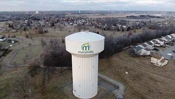
Photograph
On the map
Show this system's territory on the map — 4 ZIP codes in all.
Sources
U.S. EPA SDWIS and Community Water System Service Area Boundaries (v3, 2026), Ohio EPA primacy data, 2020 census blocks: the system serving most residents, traced through purchases to the treating utility; Ohio EPA 2023 Sewer and Water Rate Survey (Ohio State, May 2025) for household bills; Ohio EPA DEFA loan awards since 2016 for the loans paragraph · EPA SDWIS · EPA service area boundaries · Ohio EPA drinking water · Ohio EPA rate survey
Marysville City's own pages: marysvilleohio.org, marysvilleohio.org
Notable facts: marysvilleohio.org, marysvilleohio.org, marysvilleohio.org, en.wikipedia.org
History: marysvilleohio.org, marysvilleohio.org, marysvilleohio.org, marysvilleohio.org
Water quality: marysvilleohio.org, marysvilleohio.org
Planned work: marysvilleohio.org
Capital projects: marysvilleohio.org, marysvilleohio.org, marysvilleohio.org, marysvilleohio.org
Rates: marysvilleohio.org, marysvilleohio.org
Sewers: marysvilleohio.org, marysvilleohio.org, marysvilleohio.org
Treatment: marysvilleohio.org, marysvilleohio.org, marysvilleohio.org
Supply stress: marysvilleohio.org, marysvilleohio.org, en.wikipedia.org