How Hilliard began
Hilliard grew out of farmland that John Reed Hilliard bought in Norwich Township in 1852 and, in the fall of 1853, had surveyed into village lots to catch the new Columbus, Piqua and Indiana Railroad; the depot settlement was first called Hilliard's Station and, informally, 'Hilliards' for generations after that. The village incorporated on July 13, 1869, and stayed a small railroad shipping and milling town of a few hundred people through the 19th century, its brick Main Street storefronts, Odd Fellows lodge, and Methodist church still standing as its oldest landmarks. It sits in Norwich Township along the Scioto River, with Big Darby Creek and the old Darby Plains prairie a few miles west, land that lay within Wyandot territory before cession and removal. Suburban subdivisions and a 1960s tie-in to Columbus's regional water and sewer system opened Hilliard to rapid growth; it became a city in 1960 and is today a Columbus suburb of more than 37,000 people.
Settled 1820, platted 1853, incorporated 1869, by John Reed Hilliard.
Where the name comes from
Hilliard is named for John Reed Hilliard (recorded in the 1880 county history as 'John R. Hilliard'), who bought farmland in Norwich Township in 1852 and, in the fall of 1853, had it surveyed into village lots as the Columbus, Piqua and Indiana Railroad was built through the area; the depot and warehouse he put up became known as Hilliard's Station. A post office opened under the name Hilliard in 1854. The county history of 1880 already writes 'Hilliard,' never 'Hilliards,' for the founding and everything after it -- but see the story below on how long the plural spelling actually lasted in practice.
Before the town
Norwich Township, where Hilliard sits, lay within the Scioto valley territory the Wyandot held into the early 1800s, and the only place-specific Native American memory found for the immediate Hilliard area is a camping ground: the 1880 county history of Franklin and Pickaway counties records that when Norwich Township pioneers held a reunion in a grove on Abraham Sells' farm east of the village in 1879, the camping ground of 'chief Crane, of the Wyandot tribe of Indians' was still pointed out a short distance from a nearby spring. No mounds, earthworks, villages, or trails specific to Hilliard or Norwich Township turned up in the sources searched for this file. A few miles west, along Big Darby Creek and across the Darby Plains prairie that once covered the area, the record is richer, though it belongs to neighboring townships rather than to Hilliard itself: a Hilliard-area local-history source describes a Mingo presence in Brown Township, along Big Darby Creek, that reportedly outnumbered white settlers through the early pioneer years, and says the Shawnee leader Tecumseh 'frequented the area' and that Jonathan Alder, a white captive raised among the Mingo and Shawnee, lived most of his life along the creek nearby. Sources disagree on the creek's Native name: that same local-history source gives 'Crawfish Creek,' while a Franklin County park district history says the Wyandot called it 'Ollentangy' (a name 1833 state legislation reassigned to today's separate Olentangy River) and that 'Darby' itself is an Anglicization of the name of a Native chief who lived along the stream -- a claim echoed independently in the same 1880 county history for Pickaway County's Darby Township. The Wyandot are described in that county history's general chapters as having held 'principal possession ... of the lands now included in Franklin county' before the cessions and removal that culminated in the tribe leaving its last Ohio reserve, at Upper Sandusky, in 1843; that broader county-wide narrative, along with any prehistoric Adena, Hopewell, or Fort Ancient sites, is left to the Franklin county file rather than repeated here, since nothing found ties it specifically to Hilliard.
Nations recorded here: Wyandot, Mingo (Seneca-Cayuga), Shawnee.
- Wyandot camping ground on the Sells farm ('chief Crane') (camp) — East of Hilliard, at a spring on the farm of Abraham Sells, near the Scioto River, Norwich Township, No date given; still pointed out to local residents as of 1879 (archive.org)
- Big Darby Creek corridor / Darby Plains (other) — West of Hilliard, along Big Darby Creek through Brown, Prairie, and Pleasant townships, Franklin County, Pioneer era, before white settlement began in the area in 1808 (hilliardhistoryexpress.org)
Timeline
- — Daniel Brunk and his family, the first settlers recorded in what became Norwich Township, settle half a mile south of Hayden Run.
- — Norwich Township is organized and separated from Washington Township, named, by tradition, for early resident Thomas Backus's hometown of Norwich, Connecticut.
- — John Laird settles on land adjoining what would become the village of Hilliard, in 1820 or 1821, among the first settlers immediately at the site.
- — Norwich Township holds a two-day squirrel hunt; Abraham Sells takes first prize (80 bushels of corn) for 150 squirrels, out of several thousand killed township-wide.
- — John Reed Hilliard buys farmland in Norwich Township from Hoseah High and Abraham Wendell, along the surveyed route of the Columbus, Piqua and Indiana Railroad.
- — In the fall, Hilliard has his farm surveyed into village lots and builds a warehouse by the tracks as the Columbus, Piqua and Indiana Railroad comes through; the settlement is platted as Hilliard's Station.
- — A post office opens under the plain name Hilliard (the earlier township post office at Smiley's Corners closes the same year); a steam sawmill is built by James Ralston and Kirkpatrick, and the Methodist Episcopal congregation builds its first church at the station.
- — The Village of Hilliard is incorporated on July 13 with about 280 residents; John R. L. Seegur is elected its first mayor.
- — A separate school district is organized for Hilliard, although classes had already been held in and near the village for years.
- — Norwich Township pioneers hold a reunion at a grove on Abraham Sells' farm east of the village, near the spring where a Wyandot chief's camp was still remembered.
- — The Methodist Episcopal congregation and the Odd Fellows lodge (chartered 1867) each complete new brick buildings on Main Street; both still stand as Hilliard's oldest commercial-district landmarks.
- — The Hilliard Methodist Episcopal Church (August 4), Dr. James Merryman House, and Odd Fellows Hall (both May 26) are listed on the National Register of Historic Places.
- — The Hilliard Power and Light Company is incorporated, bringing the village its first local electric utility.
- — Hilliard reaches a population of 5,633 and is granted city status by the Ohio Secretary of State on December 12; residents had continued calling the place 'Hilliards' in everyday speech up to about this point.
- — Passenger and freight rail service through Hilliard ends; the 1886 depot is later preserved and moved to Weaver Park.
Stories
Hilliard's Station Becomes 'Hilliards,' Then Hilliard
In the fall of 1853, John Reed Hilliard had his Norwich Township farm surveyed into building lots along the newly graded Columbus, Piqua and Indiana Railroad, and the depot and warehouse he built there became known as Hilliard's Station. A post office opened under the plain name Hilliard in 1854, and the detailed 1880 county history -- written by neighbors who had watched the village grow up -- uses 'Hilliard,' never 'Hilliards,' for the 1853 founding and everything since. Yet the plural spelling refused to die in everyday and commercial use: Sanborn fire-insurance survey maps of the business district, drawn for insurance underwriters rather than the post office, are titled 'Hilliards, Franklin County, Ohio' in 1922, in 1929, and again as late as 1946. A local history group, Hilliard History Express, states that many residents kept calling their town 'Hilliards' in conversation right up until it became a city in 1960, when the single official spelling finally won out for good. The sources disagree, in other words, on how quickly the 's' actually disappeared: officially by 1854, but in practice -- on maps and in speech -- for roughly a century more.
A Spring, a Grove, and a Wyandot Chief's Camp
East of the new village, farmer Abraham Sells kept a fine spring and a shady grove above a long stretch of slack water on the Scioto River. When Norwich Township's aging pioneers organized an association and held their first reunion there in the summer of 1879, the 1880 county history noted that the camping ground of 'chief Crane, of the Wyandot tribe of Indians,' was still pointed out a short distance from the spring -- the only place-specific memory of Native presence recorded for the immediate Hilliard area in the sources searched for this file. The same history describes the Wyandot generally as having held 'principal possession' of the Scioto valley lands that became Franklin County before cession and removal pushed the nation first onto a small reserve at Upper Sandusky and finally, by 1843, out of Ohio entirely. Sells, for his part, clearly saw the commercial possibilities of his ground as well as its history: the county history predicted his grove and its boat-friendly river frontage 'will soon become a favorite resort for pleasure seekers.' No mounds, earthworks, or other Wyandot sites turned up in this research for Hilliard specifically; broader Franklin County Native history is covered in the county file.
From Andersonville to Hilliard: Dr. James Merryman
Dr. James Merryman practiced medicine in Hilliard in the years after the Civil War, in which he had served and been held as a prisoner of war at the infamous Confederate camp at Andersonville. He went on to serve in the Ohio General Assembly's 82nd session before returning to his medical practice in the small railroad village. Around 1879 he built the T-plan Italianate farmhouse that still stands at what is now 5232 Norwich Street, described as the only house of its kind in Hilliard; the 1880 county history, written the following year, notes that 'Dr. Merryman come soon after Dr. Seeds,' referring to Dr. R. Z. Seeds, who had set up Hilliard's practice in 1870, and lists a J. M. Merryman serving as Norwich Township treasurer that same year. The house was added to the National Register of Historic Places on May 26, 1988.
Sixteen Years Before They Had a Hall
Norwich Lodge No. 385 of the Independent Order of Odd Fellows was chartered on June 25, 1867, with charter members including James C. Gray, William Roberts, J. H. Kidwell, W. M. Gill, and several other early Hilliard men, according to the 1880 county history. The lodge met elsewhere in the village for sixteen years before finally building its own brick hall at 4065 Main Street in 1883, in the Italianate style, with a pressed-metal cornice, paired brackets, and four tall arched second-story windows; the ground floor held two shops while the lodge used the upper room, finished with hoodmolds, wainscoting, and ornamental metal ceiling work. Wikipedia's account of the building calls it one of just two 19th-century brick commercial buildings surviving in the city in anything close to original condition -- a rare physical survivor from the years when Hilliard, in the article's words, 'was just a small farming community.' It was added to the National Register of Historic Places on May 26, 1988, the same day as the Hilliard Methodist Episcopal Church and the Dr. James Merryman House.
A Burned Schoolhouse and a Fight Over Where to Build
Hilliard's Methodist Episcopal class organized around 1842 in a log schoolhouse east of the future village and met there for over a decade. About 1853, according to the 1880 county history, the schoolhouse was burned 'by some persons who did not wish church services held there' -- an act of arson the history records flatly, without naming a suspect or a motive beyond opposition to the meetings themselves. The congregation then split over where to rebuild: in 1854, eight members favored building near the old, burned site, while seven pushed for a new church at Hilliard's Station instead. The station faction organized a subscription drive, raised the money, and won -- the church went up at Hilliard in 1854, with Samuel Crum overseeing much of the construction, and by 1876 membership had grown past three hundred, enough to spin off two daughter congregations elsewhere in the township. The building later replaced by the present 1883 Gothic Revival church (now Hilliard United Methodist Church, listed on the National Register on August 4, 1988) stands today as the only 19th-century church building in Hilliard to have survived, according to its Register listing.
The Register-Listed Cottage That Isn't There Anymore
The E. Boles Cottage, at 5350 Hayden Run Road, was added to the National Register of Historic Places on April 11, 1979, one of a batch of rural Norwich Township buildings listed that day. By the time a Wikimedia Commons volunteer photographed the address in February 2014, the ground on the north side of Hayden Run Road was empty, snow-covered land -- the accompanying photo description states that the building, which it identifies as the 'Frantz House' and dates to about 1870, had been destroyed, though it remains on the Register on paper. The sources disagree on the vanished building's name: the Wikipedia list of Franklin County's National Register properties calls it the E. Boles Cottage; the Commons photograph of the empty site calls it the Frantz House. Nothing found in this research resolves whether these are two names for the same building or a mismatched caption, and no image of the structure itself, only of the vacant lot, was located. It is a reminder that a National Register listing records a moment in a building's life, not a guarantee of its future -- several of the rural buildings listed alongside it in 1979 have fared no better.
Photographs
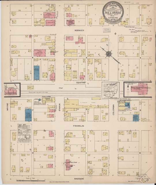
Photo: Sanborn Map Company, via Library of Congress / Wikimedia Commons, public domain · Wikimedia Commons
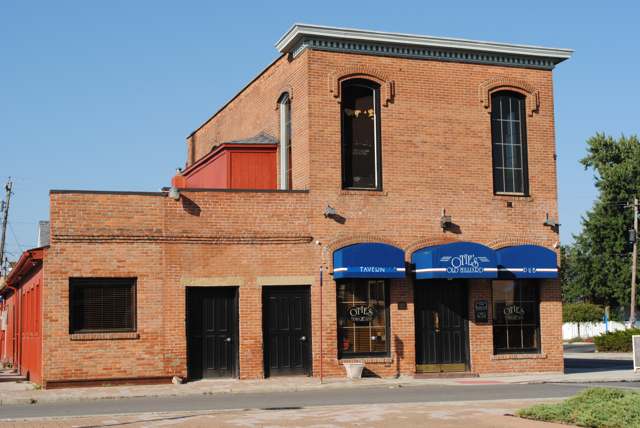
Photo: Wdzinc, Wikimedia Commons, CC BY-SA 3.0 · Wikimedia Commons
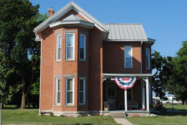
Photo: Wdzinc, Wikimedia Commons, CC BY-SA 3.0 · Wikimedia Commons
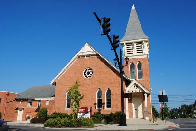
Photo: Wdzinc, Wikimedia Commons, CC BY-SA 3.0 · Wikimedia Commons
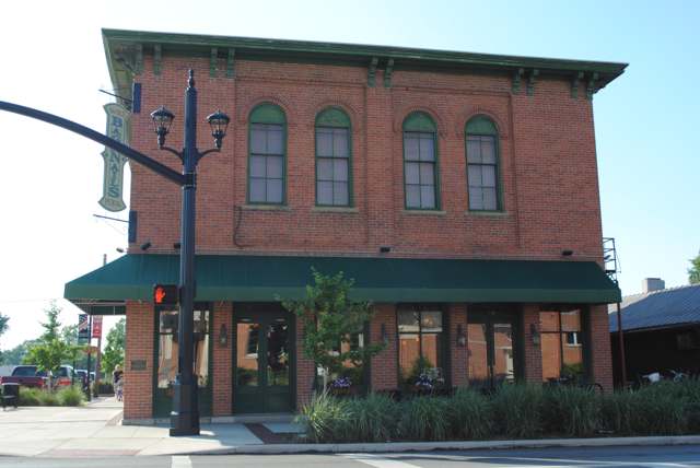
Photo: Wdzinc, Wikimedia Commons, CC BY-SA 3.0 · Wikimedia Commons
Local history sources: en.wikipedia.org · hilliardohio.gov · en.wikipedia.org · en.wikipedia.org · en.wikipedia.org · en.wikipedia.org · en.wikipedia.org · archive.org · en.wikipedia.org · en.wikipedia.org · en.wikipedia.org · metroparks.net · commons.wikimedia.org · commons.wikimedia.org · commons.wikimedia.org · commons.wikimedia.org · commons.wikimedia.org · commons.wikimedia.org · commons.wikimedia.org · commons.wikimedia.org · commons.wikimedia.org · hilliardhistoryexpress.org · hilliardhistoryexpress.org · hilliardhistoryexpress.org · hilliardhistoryexpress.org · hilliardhistoryexpress.org · hilliardhistoryexpress.org
Water
Scioto River intake at the plant on Dublin Rd, a few miles below Griggs Dam, opposite Marble Cliff The water here
- Columbus Public Water System100% of residentsScioto River (Griggs & O'Shaughnessy), Hoover Reservoir on Big Walnut Ck, plus wells
- Aqua Ohio - Timberbrook Pw0% of residentsGroundwater wells (2 wells)
- Del-co Water Company, Inc.0% of residentsOlentangy River, O'Shaughnessy and Alum Creek reservoirs, plus Knox County wells
- Hayden Heights MHP0% of residentsGroundwater wells (2 wells)
- Suburbans Community MHP0% of residentsGroundwater wells (2 wells)
- Country Side Mobile Home0% of residentsGroundwater wells
Its ZIP codes
Each ZIP code that touches Hilliard, with the share of its residents who live here and the same headline figures as the ZIP page.
The county
Franklin County: 45 ZIP codes, 42 cities, villages and townships, 1,356,733 people.
Nearby places
Cite this page
Cite this page as:
Cracked Buckeye (Open Shower Co), "Hilliard, Franklin County", https://crackedbuckeye.com/place/hilliard/, built 2026-09-16, accessed [date].
Machine-readable: /api/place/hilliard.json (open JSON, CC BY 4.0 for the compilation; the underlying records keep their own terms) · How to cite · Report a correction · Built 2026-09-16