Local events in Lemon Township, Butler County
Nothing is posted for Lemon Township itself yet; here is what is on within 10 miles. All local events in Lemon Township, Butler County
Know a calendar we should watch? Send the link
Checked October 20; the events page is refreshed daily.
How Lemon Township, Butler County began
Lemon Township, one of Butler County's thirteen townships, was established in 1803 and originally covered about 36 square miles, including all of the future Middletown and most of the future Monroe on the Butler County side; Madison Township was divided off from it on May 7, 1810. Its southern portion fell within the Symmes Purchase. The township's small communities include Excello, an unincorporated place on the Miami and Erie Canal, and the former Blue Ball, founded in 1820 at the Dixie Highway crossing and named for the blue ball painted on its tavern's signboard so illiterate travelers could find it; Blue Ball was annexed into Middletown in 1994. The rest of the township remains farmland, with 2,343 residents recorded in the most recent count.
Incorporated 1803, by Organized as one of Butler County's original townships.
Where the name comes from
The 1905 county history gives no reason for the name Lemon; it says the township originally included the later Madison Township until May 7, 1810.
Before the town
No Native village, trail, or burial site specifically within Lemon Township was found in the sources consulted. Part of the township's southern land fell within the 1788 Symmes Purchase, whose validity against Native title remained unsettled until the 1795 Treaty of Greenville. The 1905 county history notes that the first settlement was on the Little Prairie, a natural meadow of about a mile by half a mile on both sides of the Miami River, and that Symmes's northern line passes through the township just south of Dick's Creek.
Timeline
- — Thomas Irwin and David Logan settle in the township as early as 1795, and Joseph Williamson and Alexander McConnell in 1796; Daniel Doty, John Reed, Stephen Vail and Moses Potter come before 1800.
- — The Little Prairie Baptist church, on the natural meadow along the Miami River, is admitted by the association in 1800 or 1801 (Judge Dunlevy says 1800, the minutes 1801) with eleven members under Elder Philip Sutton; it seems to have disbanded after a quarrel with Elk Creek church in 1805.
- — The Swamp Creek congregation, later Mount Pleasant United Presbyterian, is organized before this date near Monroe; the congregation builds its fourth church in Monroe village in 1854.
- — Lemon Township is established, originally covering about 36 square miles including the future sites of Middletown and most of the Butler County part of Monroe.
- — Madison Township is divided from Lemon Township on May 7.
- — Monroe is laid out by Nathan Sackett and John H. Piatt on the Cincinnati-Dayton pike, a stagecoach stop where fares between the two cities fell in a rate war from two dollars and a half to fifty cents.
- — The community of Blue Ball is established at the intersection of what became U.S. Route 25 (the Dixie Highway) and the Warren County line, named for the blue ball painted on its tavern's signboard.
- — Robert Coddington and Samuel Dickey found Amanda on the Miami and Erie Canal; Benjamin LeSourd buys ninety-five acres at about the time the canal is built to found LeSourdsville.
- — The Harmony church (First Presbyterian) is organized at Monroe with sixteen members.
- — A post office is established at Blue Ball, a stage-coach tavern stand whose name came from its tavern sign.
- — The Monroe Catholic church is built under Father Smith.
- — The township outside Middletown has 1,825 people; Middletown, once part of Lemon, grows from 7,681 to 9,215 between 1890 and 1900.
- — Middletown photographer Marion G. Warner takes two photographs of a barber shop on Oxford State Road in Amanda, with the Baptist Church, at the corner of Forrer and Mulberry streets by the railroad tracks, in the background.
- — A photograph records the Miami and Erie Canal at Excello, where the parallel railroad tracks turned northeast.
- — The community of Blue Ball is annexed by the city of Middletown.
- — The census counts 16,885 people in Lemon Township.
Stories
A sign for people who couldn't read
When settlers established a small crossroads community in 1820 at the point where the Dixie Highway crossed into Warren County, its most memorable feature turned out to be its tavern sign: a simple blue ball, painted large enough to be seen from the road. In an era when many travelers along the frontier roads could not read, a picture did the job a name on a sign could not, and the blue ball became such a fixed landmark that it gave the whole community its name. Blue Ball stayed a recognizable place on Butler County maps for well over a century and a half, long after literacy made picture-signs unnecessary, until the city of Middletown annexed it in 1994 -- absorbing a place-name into its own boundaries that had begun life as a painted image meant to be understood without a single written word.
LeSourd's great city that wasn't
When the Miami and Erie Canal was being built, Benjamin LeSourd bought ninety-five acres from Abraham Freeman in the northern part of Lemon Township, intending, the 1905 county history says, to build a great city. He opened a big store, but after a year or two he failed and sold out to Thomas Ward. Freeman, the earliest settler there, had come before 1800 and built a sawmill that went down about 1815; the first house in the settlement was the Red Buck tavern, kept by John Freeman. A union church was built just before the Civil War and passed to the Presbyterians about 1876. The village that kept LeSourd's name never grew into anything like a city. At Monroe, on the Cincinnati-Dayton pike, the contest was over stage passengers rather than lots: at one time three or four lines of stagecoaches were running, and competition cut the fare from $2.50 to fifty cents.
Photographs
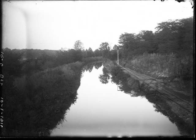
Photo: Marion G. Warner, Midpointe Library System, via DPLA, public domain · Wikimedia Commons
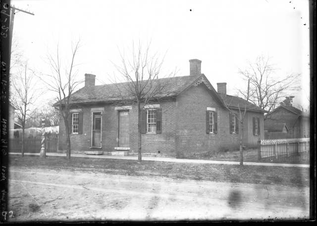
Photo: Marion G. Warner (1861-1922); Midpointe Library System, via the Digital Public Library of America and Ohio Digital Network, public domain · Wikimedia Commons
Local history sources: en.wikipedia.org · en.wikipedia.org · commons.wikimedia.org · archive.org · commons.wikimedia.org
Water
Six groundwater wells on the west side of the Great Miami River along Cincinnati-Dayton Road / Oxford State Road, pumped to the treatment plant on Columbia Ave The water here
- Butler Co. Water District 245% of residentsHamilton wells (Great Miami aquifer) + Cincinnati (Ohio River + wells)
- Middletown City36% of residentsGreat Miami Buried Valley Aquifer (wells)
- Hamilton Public Water System12% of residentsGreat Miami Buried Valley Aquifer (wells)
- Monroe City4% of residentsGreat Miami Buried Valley Aquifer (wells)
- Southwest Regional Water District1% of residentsGreat Miami Buried Valley Aquifer (wells)
- New Miami Village1% of residentsGroundwater wells (3 wells)
- Fairfield City0% of residentsGreat Miami Buried Valley Aquifer (wells)
Hospitals, fire stations and more
Inside Lemon Township, Butler County's boundary: 3 poor-rated bridges, 6 Toxics Release Inventory facilities and 1 spill case. Press a pin or a name for its whole record and its source.
Bridges rated poor (3)
-
Hankins Rd over Norfolk Southn RrPoor · built 1977
- Condition
- Poor: a deck, superstructure, substructure or culvert rated 4 or below on the 0 to 9 scale
- What it is
- Bridge
- Built
- 1977
- Length
- 46 ft
- Owner
- County
- Vehicles a day
- 2,210
- Coordinates
- 39.43071, -84.40297
National Bridge Inventory (source) ↗ Street map and directions ↗
-
SR 122 over Middletown Hydraulic CnlPoor · built 1960
- Condition
- Poor: a deck, superstructure, substructure or culvert rated 4 or below on the 0 to 9 scale
- What it is
- Culvert
- Built
- 1960
- Length
- 14 ft
- Owner
- State
- Vehicles a day
- 1,670
- Coordinates
- 39.51682, -84.41021
National Bridge Inventory (source) ↗ Street map and directions ↗
-
Yankee Rd over Cold Water CreekPoor · built 1988
- Condition
- Poor: a deck, superstructure, substructure or culvert rated 4 or below on the 0 to 9 scale
- What it is
- Bridge
- Built
- 1988
- Length
- 8 ft
- Owner
- County
- Vehicles a day
- 2,350
- Coordinates
- 39.43709, -84.38901
National Bridge Inventory (source) ↗ Street map and directions ↗
Source: FHWA National Bridge Inventory 2025. "Poor" means one major part rated 4 or below on the 0 to 9 scale; it calls for repair, not closing, unless the state posts or closes the bridge.
Facilities reporting toxic releases (6)
-
Crystal Tissue CoToxics Release Inventory · Middletown
- Address
- 3120 S. Verity Pky., Middletown, OH 45044
- County
- Butler County
- Status
- Reports to the Toxics Release Inventory (active)
- EPA program ID
- 45042THCYR3120S
- EPA registry ID
- 110000392548
EPA facility record ↗ EPA Facility Registry Service (source) ↗ Street map and directions ↗
-
Evertz Technology ServicesToxics Release Inventory · Middletown
- Address
- 2601 S Verity Pkwy Building 102Y, Midd Cities Ind, Middletown, OH 45043
- County
- Butler County
- Status
- Reports to the Toxics Release Inventory
- EPA program ID
- 45043VRTZT261SV
- EPA registry ID
- 110025316986
EPA facility record ↗ EPA Facility Registry Service (source) ↗ Street map and directions ↗
-
Rps Composites Ohio, Inc.Toxics Release Inventory · Middletown
- Address
- 2601 S Verity Pkwy, Middletown, OH 45044
- County
- Butler County County
- Status
- Reports to the Toxics Release Inventory (closed)
- EPA program ID
- 45044CHTQF261SV
- EPA registry ID
- 110037144033
EPA facility record ↗ EPA Facility Registry Service (source) ↗ Street map and directions ↗
-
Simpson Paper CoToxics Release Inventory · Middletown
- Address
- 3560 South Main Street, Middletown, OH 45044
- County
- Butler County
- Status
- Reports to the Toxics Release Inventory (closed)
- EPA program ID
- 45044SMPSN3560S
- EPA registry ID
- 110002112810
EPA facility record ↗ EPA Facility Registry Service (source) ↗ Street map and directions ↗
-
Smurfit Graphic ArtsToxics Release Inventory · Middletown
- Address
- 2205 S. Verity Pky., Middletown, OH 45044
- County
- Butler County
- Status
- Reports to the Toxics Release Inventory (active)
- EPA program ID
- 45042SMRFT2205S
- EPA registry ID
- 110000392520
EPA facility record ↗ EPA Facility Registry Service (source) ↗ Street map and directions ↗
-
Xerox Corp Esso/MonroeToxics Release Inventory · Middletown
- Address
- 6500 State Rd. 63, Middletown, OH 45044
- County
- Butler County
- Status
- Reports to the Toxics Release Inventory (active)
- EPA program ID
- 45044XRXCR6500S
- EPA registry ID
- 110000498765
EPA facility record ↗ EPA Facility Registry Service (source) ↗ Street map and directions ↗
Source: EPA Facility Registry Service, Toxics Release Inventory reporters. Reporting a release is required of large users of listed chemicals; it is not by itself a violation.
Spills reported since 2021 (1)
-
Fuel Diesel / Diesel Fuel (Vehicle On Or Off Road)2022-08-05 · Lemon Twp
- Reported
- 2022-08-05
- What spilled
- Fuel Diesel / Diesel Fuel (Vehicle On Or Off Road)
- Largest amount reported
- 150 gallons
- Where
- Lemon Twp, Butler County
- Ohio EPA district office
- SWDO
- Ohio EPA case number
- 2208EPA0001182
Ohio EPA spill reports (source) ↗ Street map and directions ↗
Source: Ohio EPA emergency response spill reports, 2021 to September 2026, one point per case where Ohio EPA placed it. A report is what the caller or responder recorded; amounts are often blank or estimated.
Its ZIP codes
Each ZIP code that touches Lemon Township, Butler County, with the share of its residents who live here and the same headline figures as the ZIP page.
Local government
Who holds office in Lemon Township, Butler County, how its elections and ballot issues came out, and the state auditor's record.
Who holds office
| Office | Name | Party | Term ends | Contact |
|---|---|---|---|---|
| Township Fiscal Officer | Rita Tannreuther | 11/2/2027 | ||
| Township Trustee | Michael Garver | 11/2/2027 | ||
| Township Trustee | Kevin Robert Majors | 11/6/2029 | ||
| Township Trustee | Joe Routson | 11/6/2029 |
Roster as of 2026-07-27: county board of elections.
Auditor of State record
- No fiscal caution, watch or emergency on the Auditor of State's lists.
- Agreed Upon Procedures, 2023 to 2024, released 2025-07-31
The county
Butler County: 13 ZIP codes, 22 cities, villages and townships, 382,868 people.
Nearby places
Quick answers
What county is Lemon Township, Ohio in?
Lemon Township, Butler County is a township in Butler County, Ohio, with 2,343 residents.
When was Lemon Township, Ohio founded?
Lemon Township, Butler County was incorporated 1803. Founders on record: Organized as one of Butler County's original townships. Source
How did Lemon Township, Ohio get its name?
The 1905 county history gives no reason for the name Lemon; it says the township originally included the later Madison Township until May 7, 1810. Source
What ZIP code is Lemon Township, Ohio?
Most of Lemon Township, Butler County is in ZIP code 45044.
Where does Lemon Township, Ohio get its water?
The main water source for Lemon Township, Butler County (Butler Co. Water District 2): Six groundwater wells on the west side of the Great Miami River along Cincinnati-Dayton Road / Oxford State Road, pumped to the treatment plant on Columbia Ave.
Cite this page
Cite this page as:
Cracked Buckeye, "Lemon Township, Butler County", https://crackedbuckeye.com/place/lemon-township-butler-county/, built 2026-10-31, accessed [date].
How to cite · Report a correction · Built 2026-10-31
