Local events in Turtle Creek Township, Warren County
Nothing is posted for Turtle Creek Township itself yet; here is what is on within 10 miles. All local events in Turtle Creek Township, Warren County
Know a calendar we should watch? Send the link
Checked October 20; the events page is refreshed daily.
How Turtle Creek Township, Warren County began
Turtlecreek Township was organized by the Warren County Commissioners on August 15, 1804, taking its name from Turtle Creek, a 13.7-mile Little Miami tributary that was itself named for the Miami war leader Little Turtle (Meshekinoquah). The 62-square-mile township wraps entirely around Lebanon, the county seat, which withdrew from it in the 1960s to form its own paper township, and pieces of Turtlecreek have since been annexed into Mason, Middletown, Monroe and Springboro. Its surviving rural landmark is the stone-built Crossed Keys Tavern of 1802, which stands across the Little Miami River from the site of the former village of Fort Ancient.
Incorporated August 15, 1804, by Warren County Commissioners.
Where the name comes from
Named for Turtle Creek, which flows through the township into the Little Miami River; the creek's name honors Little Turtle (Meshekinoquah), the Miami war chief who led Native forces to major victories against U.S. armies in the early 1790s before signing the Treaty of Greenville in 1795.
Before the town
The township's name is itself a piece of Native American history: Turtle Creek honors Chief Little Turtle of the Miami, whose people held this stretch of the Little Miami Valley as hunting ground before white settlement. Warren County's own historical society records that the Miami had no permanent town within the future county's bounds when settlement began, but that the land was ceded outright at the Treaty of Greenville on August 3, 1795. The Crossed Keys Tavern, built in 1802 on what is now State Route 350, stands across the Little Miami River from the site of the former village of Fort Ancient, a nineteenth- and early twentieth-century settlement at the foot of the Fort Ancient earthworks. No specific Native village, camp or burial site within the township's own boundary (as distinct from the county as a whole) was found in the sources reviewed.
Nations recorded here: Miami, Shawnee, Hopewell culture.
Timeline
- — The Treaty of Greenville cedes Miami and Shawnee claims to over 16.9 million acres including the future Warren County to the United States.
- — The stone building later known as the Crossed Keys Tavern is built on what became State Route 350, east of Lebanon.
- — Turtlecreek Township is organized by the Warren County Commissioners on August 15.
- — The Crossed Keys building operates as a tavern.
- — The city of Lebanon, the county seat that the township surrounds, withdraws from Turtlecreek Township and forms its own paper township.
- — The Crossed Keys Tavern is listed on the National Register of Historic Places (October 21).
- — The City of Lebanon, at the township's center, establishes a stormwater utility to address an infrastructure backlog and comply with EPA stormwater-quality requirements.
- — Construction begins on 40,000 feet of water main and a new pump station bringing Greater Cincinnati Water Works water into the Lebanon area from the Richard Miller Treatment Plant.
Stories
A township named for a Miami war chief
Turtlecreek Township carries, in its own name, a piece of the history of the people who lived on this land before it was Warren County at all. Turtle Creek, the stream that gives the township its name, was named for Little Turtle (Meshekinoquah), the Miami sagamore who by 1790 had become the most important war leader of a Native confederacy that twice defeated U.S. armies sent against it, at the Battle of the Wabash in 1791 in the worst defeat the United States ever suffered at Native American hands. Little Turtle went on to sign the Treaty of Greenville in 1795 that ceded this land, and spent his later years advocating for peace and for Native adoption of American farming methods before his death in 1812 -- a far more complicated legacy than the creek and township names alone suggest.
A tavern across the river from a lost village
In 1802, seven years after the Greenville cession opened this stretch of the Little Miami Valley to settlement, a stone tavern went up on the road east of Lebanon that is now State Route 350. It operated as the Crossed Keys Tavern from about 1809 to 1820, serving travelers on one of the main roads out of the new county seat. Directly across the river from the tavern stood the village of Fort Ancient, a later settlement named for the great hilltop earthworks above it.
A county seat that left its own township
For a century and a half, Lebanon -- Warren County's seat -- sat inside Turtlecreek Township the way most Ohio county seats sit inside their home township. That changed in the 1960s, when Lebanon withdrew from Turtlecreek Township entirely and organized itself as its own 'paper township,' a legal maneuver some growing Ohio cities used to escape township-level taxation and control. Geographically nothing changed -- Lebanon still sits surrounded by Turtlecreek Township on every side -- but administratively the county seat and the rural township that had carried its name and infrastructure for a century and a half became separate governments, a split that still shapes local governance today.
Photographs
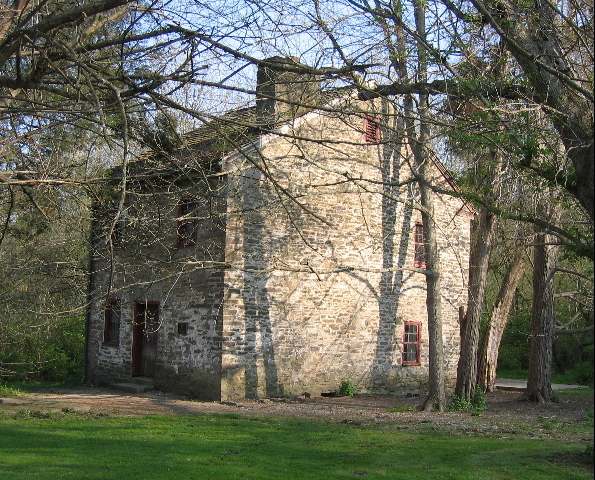
Photo: Mbeatty, CC BY-SA 4.0 · Wikimedia Commons
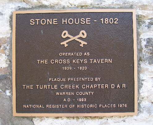
Photo: Mbeatty, CC BY-SA 4.0 · Wikimedia Commons
Local history sources: en.wikipedia.org · en.wikipedia.org · en.wikipedia.org · en.wikipedia.org · en.wikipedia.org · wcgsohio.org · en.wikipedia.org · commons.wikimedia.org · commons.wikimedia.org · lebanonohio.gov · cincinnati-oh.gov
Historic places
1 place in Turtle Creek Township, Warren County on the National Register of Historic Places. Press a pin or a name for its whole record.
-
Crossed Keys TavernBuilding · Lebanon · listed 1976
- Address
- E of Lebanon on OH 350
- Where
- Lebanon, Warren County · ZIP 45054
- What it is
- Building
- Listed on the National Register
- 1976
- NRIS reference number
- 76001542
- Coordinates
- 39.40689, -84.10329
National Register file (NPS) ↗ Search Wikipedia ↗ Street map and directions ↗ On the Cracked Buckeye map
Source: National Park Service, National Register of Historic Places point file. The listing year is shown where NPS's certification date agrees with the listing's reference number. Listing recognizes significance; it does not restrict a private owner.
Water
Ohio River intake at the plant's riverfront on Kellogg Ave in the California neighborhood, east Cincinnati The water here
- Lebanon City64% of residentsOhio River + Great Miami Aquifer (via Cincinnati GCWW)
- Western Water Company11% of residentsLittle Miami River valley wells (51%) plus Cincinnati Ohio River water (49%)
- Middletown City7% of residentsGreat Miami Buried Valley Aquifer (wells)
- Cincinnati Public Water System6% of residentsOhio River (Miller Plant, ~88%) plus Great Miami Buried Valley Aquifer wells (~12%)
- Warren Co. Pennyroyal Area4% of residentsGreat Miami Buried Valley Aquifer (own wells)
- Butler Co. Water District 24% of residentsHamilton wells (Great Miami aquifer) + Cincinnati (Ohio River + wells)
- Franklin Public Water System2% of residentsGreat Miami Buried Valley Aquifer (own wells)
- Warren Co. Socialville1% of residentsOhio River (Miller Plant, ~88%) plus Great Miami Buried Valley Aquifer wells (~12%)
- Monroe City1% of residentsGreat Miami Buried Valley Aquifer (wells)
- Waynesville Village1% of residentsGroundwater wells (4 wells)
- Carlisle City0% of residentsGreat Miami Buried Valley Aquifer (own wells)
- Warren County0% of residentsWells in the Little Miami and Great Miami river valley aquifers
- Springboro0% of residentsGreat Miami Buried Valley Aquifer (own wells)
- Southwest Regional Water District0% of residentsGreat Miami Buried Valley Aquifer (wells)
Hospitals, fire stations and more
Inside Turtle Creek Township, Warren County's boundary: 2 nursing homes, 3 fire and EMS stations, 2 high-hazard dams, 4 poor-rated bridges, 2 public charging sites and 19 spill cases. Press a pin or a name for its whole record and its source.
Nursing homes (2)
-
Cedarview Care Center4 of 5 stars · Lebanon
- Address
- 115 Oregonia Road, Lebanon, OH 45036
- Certified beds
- 83
- Residents on an average day
- 71
- Medicare overall rating
- 4 of 5 stars
- Health inspections
- 4 of 5 stars
- Staffing
- 2 of 5 stars
- Quality measures
- 4 of 5 stars
- Penalties since 2023
- 1 payment denial (latest 2024-04-15)
- Ownership
- For profit - Limited Liability company
- Chain
- CCH HEALTHCARE
- Takes
- Medicare and Medicaid
- Phone
- (513) 932-1121
- Medicare ID
- 365690
- Map point
- the ZIP's center (the address did not geocode)
Medicare Care Compare ↗ CMS nursing home data (source) ↗ Street map and directions ↗
-
Otterbein Lebanon Retirement Community5 of 5 stars · Lebanon
- Address
- 585 North State Route 741, Lebanon, OH 45036
- Certified beds
- 154
- Residents on an average day
- 141
- Medicare overall rating
- 5 of 5 stars
- Health inspections
- 4 of 5 stars
- Staffing
- 4 of 5 stars
- Quality measures
- 5 of 5 stars
- Penalties since 2023
- none
- Ownership
- Non profit - Corporation
- Chain
- OTTERBEIN SENIORLIFE
- Continuing care retirement community
- Yes
- Takes
- Medicare and Medicaid
- Phone
- (513) 933-5427
- Medicare ID
- 365346
Medicare Care Compare ↗ CMS nursing home data (source) ↗ Street map and directions ↗
Source: CMS Care Compare nursing home provider and penalties files; Medicare star ratings run 1 to 5.
Fire and EMS stations (3)
-
Turtlecreek Township Fire Department Bostick Station 31Lebanon
- Address
- 1255 Oregonia Road, Lebanon, OH 45036
- Coordinates
- 39.43486, -84.18263
USGS National Map structures (source) ↗ Street map and directions ↗
-
Turtlecreek Township Fire Department Station 33Lebanon
- Address
- 1550 North State Route 741, Lebanon, OH 45036
- Coordinates
- 39.46066, -84.26938
USGS National Map structures (source) ↗ Street map and directions ↗
-
Turtlecreek Township Fire Department William A Stevens Station 32Lebanon
- Address
- 670 North State Route 123, Lebanon, OH 45036
- Coordinates
- 39.44763, -84.22899
USGS National Map structures (source) ↗ Street map and directions ↗
Source: USGS National Map structures (most Ohio records last updated 2019 to 2022), checked against the Columbus and Cleveland station lists. The department that answers a call is set by jurisdiction and mutual aid, not by distance.
High-hazard dams (2)
-
Shaker Run DamShaker Creek · condition: fair
- Hazard class
- High: a failure would probably cost a life
- Condition
- Fair (assessed 05/06/2021)
- River or stream
- Shaker Creek
- Purpose
- Recreation;Water Supply
- Type
- Earth
- Height
- 90 ft
- Storage
- 6,124 acre-feet
- Completed
- 1973
- Owner type
- Private
- County
- Warren County
- Nearest town (NID)
- Oakland
- Last inspection
- 05/06/2021
- Emergency action plan
- Yes
- NID ID
- OH00553
National Inventory of Dams record ↗ National Inventory of Dams (source) ↗ Street map and directions ↗
-
Votel Lake DamTributary To Turtle Creek · condition: fair
- Hazard class
- High: a failure would probably cost a life
- Condition
- Fair (assessed 03/07/2025)
- River or stream
- Tributary To Turtle Creek
- Purpose
- Water Supply
- Type
- Earth
- Height
- 36 ft
- Storage
- 97 acre-feet
- Completed
- 1954
- Owner type
- Private
- County
- Warren County
- Nearest town (NID)
- Lebanon
- Last inspection
- 06/05/2024
- Emergency action plan
- No
- NID ID
- OH00551
National Inventory of Dams record ↗ National Inventory of Dams (source) ↗ Street map and directions ↗
Source: U.S. Army Corps of Engineers National Inventory of Dams, August 2026. "High hazard" rates what a failure would cost downstream, not how likely one is; the condition is the state's assessment.
Bridges rated poor (4)
-
Cold Springs Road over Trib L. Miami R (closed)Poor · built 1910
- Condition
- Poor: a deck, superstructure, substructure or culvert rated 4 or below on the 0 to 9 scale
- What it is
- Culvert
- Built
- 1910
- Length
- 8 ft
- Owner
- County
- Vehicles a day
- 336
- Coordinates
- 39.40776, -84.10400
National Bridge Inventory (source) ↗ Street map and directions ↗
-
CR 182 over Little Miami RiverPoor · built 1993
- Condition
- Poor: a deck, superstructure, substructure or culvert rated 4 or below on the 0 to 9 scale
- What it is
- Bridge
- Built
- 1993
- Length
- 110 ft
- Owner
- County
- Vehicles a day
- 1,179
- Coordinates
- 39.45497, -84.09911
National Bridge Inventory (source) ↗ Street map and directions ↗
-
Oregonia Road over Branch of Turtle CreekPoor · built 1970
- Condition
- Poor: a deck, superstructure, substructure or culvert rated 4 or below on the 0 to 9 scale
- What it is
- Bridge
- Built
- 1970
- Length
- 8 ft
- Owner
- County
- Vehicles a day
- 1,132
- Coordinates
- 39.43741, -84.16826
National Bridge Inventory (source) ↗ Street map and directions ↗
-
Union Road over Shaker CreekPoor · built 1969
- Condition
- Poor: a deck, superstructure, substructure or culvert rated 4 or below on the 0 to 9 scale
- What it is
- Bridge
- Built
- 1969
- Length
- 11 ft
- Owner
- County
- Vehicles a day
- 5,762
- Coordinates
- 39.45664, -84.32071
National Bridge Inventory (source) ↗ Street map and directions ↗
Source: FHWA National Bridge Inventory 2025. "Poor" means one major part rated 4 or below on the 0 to 9 scale; it calls for repair, not closing, unless the state posts or closes the bridge.
Public EV charging (2)
-
ODOT District 8 Offices2 Level 2 · Lebanon
- Address
- 505 OH-741, Lebanon, OH 45036
- Ports
- 2 Level 2
- Plugs
- J1772
- Network
- FLO
- Hours
- 24 hours daily
- Phone
- 888-356-8911
Station Locator (NREL) ↗ Alternative Fuels Data Center (source) ↗ Street map and directions ↗
-
Warren County Sports Park4 Level 2 · Lebanon
- Address
- 1408 OH-741, Lebanon, OH 45036
- Ports
- 4 Level 2
- Plugs
- J1772
- Network
- FLO
- Hours
- 24 hours daily
- Phone
- 888-356-8911
Station Locator (NREL) ↗ Alternative Fuels Data Center (source) ↗ Street map and directions ↗
Source: NREL Alternative Fuels Data Center station list (May 2026), public and open stations, the posts at one address counted as one site.
Spills reported since 2021 (19)
-
Fuel Diesel / Diesel Fuel (Vehicle On Or Off Road)2024-12-27 · Turtle Creek Twp
- Reported
- 2024-12-27
- What spilled
- Fuel Diesel / Diesel Fuel (Vehicle On Or Off Road)
- Where
- Turtle Creek Twp, Warren County
- Ohio EPA district office
- SWDO
- Ohio EPA case number
- 2412EPA0002082
Ohio EPA spill reports (source) ↗ Street map and directions ↗
-
Fuel Diesel / Diesel Fuel (Vehicle On Or Off Road)2024-12-10 · Turtle Creek Twp
- Reported
- 2024-12-10
- What spilled
- Fuel Diesel / Diesel Fuel (Vehicle On Or Off Road)
- Largest amount reported
- 110 gallons
- Where
- Turtle Creek Twp, Warren County
- Ohio EPA district office
- SWDO
- Ohio EPA case number
- 2412EPA0001992
Ohio EPA spill reports (source) ↗ Street map and directions ↗
-
Oil Petroleum Not Otherwise Specified (Nos)2024-09-25 · Turtle Creek Twp
- Reported
- 2024-09-25
- What spilled
- Oil Petroleum Not Otherwise Specified (Nos)
- Largest amount reported
- 2,520 gallons
- Where
- Turtle Creek Twp, Warren County
- Ohio EPA district office
- SWDO
- Ohio EPA case number
- 2409EPA0001645
Ohio EPA spill reports (source) ↗ Street map and directions ↗
-
Paint Nos / Lacquer (Not Specified)2023-11-13 · Turtle Creek Twp
- Reported
- 2023-11-13
- What spilled
- Paint Nos / Lacquer (Not Specified)
- Where
- Turtle Creek Twp, Warren County
- Ohio EPA district office
- SWDO
- Ohio EPA case number
- 2311EPA0001933
Ohio EPA spill reports (source) ↗ Street map and directions ↗
-
Fuel Diesel / Diesel Fuel (Vehicle On Or Off Road)2023-05-20 · Turtle Creek Twp
- Reported
- 2023-05-20
- What spilled
- Fuel Diesel / Diesel Fuel (Vehicle On Or Off Road)
- Largest amount reported
- 20 gallons
- Where
- Turtle Creek Twp, Warren County
- Ohio EPA district office
- SWDO
- Ohio EPA case number
- 2305EPA0000823
Ohio EPA spill reports (source) ↗ Street map and directions ↗
-
Fuel Diesel / Diesel Fuel (Vehicle On Or Off Road)2023-05-02 · Liberty Twp
- Reported
- 2023-05-02
- What spilled
- Fuel Diesel / Diesel Fuel (Vehicle On Or Off Road); Oil Motor / Lube Oil / Vehicle
- Largest amount reported
- 25 gallons
- Where
- Liberty Twp, Butler County
- Ohio EPA district office
- SWDO
- Ohio EPA case number
- 2305EPA0000715
Ohio EPA spill reports (source) ↗ Street map and directions ↗
-
Material Brown Reached water2023-02-10 · Null
- Reported
- 2023-02-10
- What spilled
- Material Brown
- Reached a waterway
- 83 - Dry Run
- Where
- Null, Warren County
- Ohio EPA district office
- SWDO
- Ohio EPA case number
- 2302EPA0000209
Ohio EPA spill reports (source) ↗ Street map and directions ↗
-
Drinking Water Reached water2022-06-14 · Turtle Creek Twp
- Reported
- 2022-06-14
- What spilled
- Drinking Water
- Reached a waterway
- 99 - Unnamed
- Where
- Turtle Creek Twp, Warren County
- Ohio EPA district office
- SWDO
- Ohio EPA case number
- 2206EPA0000888
Ohio EPA spill reports (source) ↗ Street map and directions ↗
-
Material Unknown Reached water2022-05-19 · Turtle Creek Twp
- Reported
- 2022-05-19
- What spilled
- Material Unknown
- Reached a waterway
- 99 - Unnamed
- Where
- Turtle Creek Twp, Warren County
- Ohio EPA district office
- SWDO
- Ohio EPA case number
- 2205EPA0000740
Ohio EPA spill reports (source) ↗ Street map and directions ↗
-
Fuel Diesel / Diesel Fuel (Vehicle On Or Off Road)2022-01-04 · Turtle Creek Twp
- Reported
- 2022-01-04
- What spilled
- Fuel Diesel / Diesel Fuel (Vehicle On Or Off Road)
- Largest amount reported
- 150 gallons
- Where
- Turtle Creek Twp, Warren County
- Ohio EPA district office
- SWDO
- Ohio EPA case number
- 2201EPA0000010
Ohio EPA spill reports (source) ↗ Street map and directions ↗
-
Fuel Diesel / Diesel Fuel (Vehicle On Or Off Road)2021-12-18 · Turtle Creek Twp
- Reported
- 2021-12-18
- What spilled
- Fuel Diesel / Diesel Fuel (Vehicle On Or Off Road)
- Where
- Turtle Creek Twp, Warren County
- Ohio EPA district office
- SWDO
- Ohio EPA case number
- 2112EPA0001882
Ohio EPA spill reports (source) ↗ Street map and directions ↗
-
Fuel Diesel / Diesel Fuel (Vehicle On Or Off Road)2021-11-15 · Turtle Creek Twp
- Reported
- 2021-11-15
- What spilled
- Fuel Diesel / Diesel Fuel (Vehicle On Or Off Road)
- Largest amount reported
- 25 gallons
- Where
- Turtle Creek Twp, Warren County
- Ohio EPA district office
- SWDO
- Ohio EPA case number
- 2111EPA0001743
Ohio EPA spill reports (source) ↗ Street map and directions ↗
-
Fuel Diesel / Diesel Fuel (Vehicle On Or Off Road) Reached water2021-07-22 · Turtle Creek Twp
- Reported
- 2021-07-22
- What spilled
- Fuel Diesel / Diesel Fuel (Vehicle On Or Off Road)
- Largest amount reported
- 10 gallons
- Reached a waterway
- 83 - Turtle Creek
- Where
- Turtle Creek Twp, Warren County
- Ohio EPA district office
- SWDO
- Ohio EPA case number
- 2107EPA0001111
Ohio EPA spill reports (source) ↗ Street map and directions ↗
-
Fuel Diesel / Diesel Fuel (Vehicle On Or Off Road) Reached water2021-06-27 · Turtle Creek Twp
- Reported
- 2021-06-27
- What spilled
- Fuel Diesel / Diesel Fuel (Vehicle On Or Off Road)
- Largest amount reported
- 50 gallons
- Reached a waterway
- 99 - Unnamed
- Where
- Turtle Creek Twp, Warren County
- Ohio EPA district office
- SWDO
- Ohio EPA case number
- 2106EPA0000937
Ohio EPA spill reports (source) ↗ Street map and directions ↗
-
Sewage Human2021-06-21 · Turtle Creek Twp
- Reported
- 2021-06-21
- What spilled
- Sewage Human
- Where
- Turtle Creek Twp, Warren County
- Ohio EPA district office
- SWDO
- Ohio EPA case number
- 2106EPA0000906
Ohio EPA spill reports (source) ↗ Street map and directions ↗
-
Oil Transformer Non Pcb2021-06-20 · Turtle Creek Twp
- Reported
- 2021-06-20
- What spilled
- Oil Transformer Non Pcb
- Largest amount reported
- 89 gallons
- Where
- Turtle Creek Twp, Warren County
- Ohio EPA district office
- SWDO
- Ohio EPA case number
- 2106EPA0000897
Ohio EPA spill reports (source) ↗ Street map and directions ↗
-
Fuel Diesel / Diesel Fuel (Vehicle On Or Off Road)2021-01-13 · Turtle Creek Twp
- Reported
- 2021-01-13
- What spilled
- Fuel Diesel / Diesel Fuel (Vehicle On Or Off Road)
- Largest amount reported
- 300 gallons
- Where
- Turtle Creek Twp, Warren County
- Ohio EPA district office
- SWDO
- Ohio EPA case number
- 2101EPA0000041
Ohio EPA spill reports (source) ↗ Street map and directions ↗
-
Fuel Diesel / Diesel Fuel (Vehicle On Or Off Road)2026-05-23 · Turtle Creek Twp
- Reported
- 2026-05-23
- What spilled
- Fuel Diesel / Diesel Fuel (Vehicle On Or Off Road)
- Largest amount reported
- 50 gallons
- Where
- Turtle Creek Twp, Warren County
- Ohio EPA district office
- SWDO
- Ohio EPA case number
- 2605EPA0000871
Ohio EPA spill reports (source) ↗ Street map and directions ↗
-
Fuel Diesel / Diesel Fuel (Vehicle On Or Off Road)2026-02-22 · Turtle Creek Twp
- Reported
- 2026-02-22
- What spilled
- Fuel Diesel / Diesel Fuel (Vehicle On Or Off Road)
- Largest amount reported
- 100 gallons
- Where
- Turtle Creek Twp, Warren County
- Ohio EPA district office
- SWDO
- Ohio EPA case number
- 2602EPA0000223
Ohio EPA spill reports (source) ↗ Street map and directions ↗
Source: Ohio EPA emergency response spill reports, 2021 to September 2026, one point per case where Ohio EPA placed it. A report is what the caller or responder recorded; amounts are often blank or estimated.
Its ZIP codes
Each ZIP code that touches Turtle Creek Township, Warren County, with the share of its residents who live here and the same headline figures as the ZIP page.
The county
Warren County: 12 ZIP codes, 24 cities, villages and townships, 222,825 people.
Nearby places
Quick answers
What county is Turtle Creek Township, Ohio in?
Turtle Creek Township, Warren County is a township in Warren County, Ohio, with 16,144 residents.
When was Turtle Creek Township, Ohio founded?
Turtle Creek Township, Warren County was incorporated August 15, 1804. Founders on record: Warren County Commissioners. Source
How did Turtle Creek Township, Ohio get its name?
Named for Turtle Creek, which flows through the township into the Little Miami River; the creek's name honors Little Turtle (Meshekinoquah), the Miami war chief who led Native forces to major victories against U.S. armies in the early 1790s before signing the Treaty of Greenville in 1795. Source
What ZIP code is Turtle Creek Township, Ohio?
Turtle Creek Township, Warren County is served by ZIP codes 45036 and 45054; 45036 holds the largest share of its residents.
Where does Turtle Creek Township, Ohio get its water?
The main water source for Turtle Creek Township, Warren County (Lebanon City): Ohio River intake at the plant's riverfront on Kellogg Ave in the California neighborhood, east Cincinnati.
Cite this page
Cite this page as:
Cracked Buckeye, "Turtle Creek Township, Warren County", https://crackedbuckeye.com/place/turtle-creek-township-warren-county/, built 2026-10-31, accessed [date].
How to cite · Report a correction · Built 2026-10-31
