How Mckean Township, Licking County began
McKean Township was surveyed as part of the United States Military District and settled beginning in 1806 by John Price, a Welshman who cleared what was locally remembered as the "Welsh Field" near the Granville township line -- the same wave of Welsh emigration that founded the Welsh Hills settlement, whose purchase bordered McKean and gradually spread into its northwest corner. The township organized in 1818 and was named for Thomas McKean Thompson, an early settler of wealth who had served as private secretary to Pennsylvania Governor Thomas McKean. Its two small villages, Fredonia (1829) and Sylvania (1838), never grew much beyond a few dozen households, and the itinerant preachers Joseph Thomas ("the Pilgrim") and Lorenzo Dow both passed through and preached here in the 1820s. Today it remains an unincorporated, rural township on Licking County's northern tier.
Settled 1806 (John Price), incorporated 1818.
Where the name comes from
The 1881 county history credits the name to Thomas McKean Thompson, an early settler described as "a gentleman of extensive information and wealth," who came from Pennsylvania after serving a number of years as private secretary to Governor McKean -- almost certainly Thomas McKean, Pennsylvania's second governor (1799-1808) -- and who "gave the name to the township." Thompson went on to serve Licking County as a commissioner from 1822 to 1825.
Before the town
The 1881 county history calls McKean's Indian history "somewhat meagre." It records an encampment on Cat Run, about a mile above its entrance into the Brushy Fork, occupied as late as 1812, when its residents disappeared; a few Indians returned to the site around 1820, but all left except one woman, who lived alone in one of the old huts until she too disappeared a short time later, "the last of the Indian race that had any kind of residence in the township." An unoccupied wigwam reportedly still stood on Edwin Runnels' farm as late as 1819. The Mound Builders left more physical trace: a small mound on the farm once occupied by Thomas McKean Thompson, about four miles from Granville; a circular fort of about an acre, with a shallow interior ditch, on James Barrick's land in the northwest part of the township, much worn down by plowing; and a smaller mound half a mile south of it, on the former Edwin Runnels farm, also nearly leveled by cultivation. The county history adds that "Mound Builders' works abound in all the townships adjoining McKean," including the well-known Newark Earthworks. The land itself was ceded by the Treaty of Greenville of 1795.
Nations recorded here: Wyandot, Shawnee, Lenape (Delaware), Miami, Ottawa.
- Mound on the Thompson farm (mound) — about four miles from Granville, on land once occupied by Thomas McKean Thompson, unspecified (Mound Builder era) (archive.org)
- Circular fort on the Barrick land (earthwork) — northwest section of McKean Township, on the land of James Barrick, unspecified (Mound Builder era) (archive.org)
- Cat Run encampment (camp) — Cat Run, about one mile above its entrance into the Brushy Fork, occupied until 1812, with a final resident remembered into the early 1820s (archive.org)
Timeline
- — The Treaty of Greenville cedes most of what becomes Ohio, including the future McKean Township, to the United States.
- — Thomas Phillips and Theophilus Rees purchase two thousand acres in what becomes northeast Granville Township, bordering the McKean township line -- the origin of the Welsh Hills settlement, which later extends slightly into McKean itself.
- — John Price, a Welshman, settles near the Granville township line and clears the ground later remembered as the "Welsh Field," becoming the township's first settler.
- — Abraham Wright, later the first justice of the peace in Newark, settles in McKean Township.
- — William Smith, a Revolutionary War soldier, settles at the junction of Cat Run and the Brushy Fork; his son John becomes one of the township's first justices of the peace in 1818.
- — McKean Township organizes, with its first election held on a white-oak log at the future site of Fredonia; thirteen votes are cast, using a hat as the ballot box.
- — Lorenzo Dow, one of the era's most eccentric traveling preachers, delivers a night sermon in a cabin in the "Blanchard settlement" near the township's southern boundary, then continues to Granville and preaches in the street the next morning.
- — A Baptist church is organized in the township, later building an edifice in Fredonia; Rev. Mr. Wileman is its earliest preacher.
- — Spencer Arnold, David Wood Jr., and S. Shaw lay out the village of Fredonia, surveyed by Edwin Runnels.
- — Jesse and Abraham Gosnell lay out the village of Sylvania.
- — The federal census counts eighty-six residents in Fredonia and fifty in Sylvania.
Stories
The Pilgrim in the Woods
One of the most memorable preachers ever to pass through McKean Township was Rev. Joseph Thomas, known everywhere as "the Pilgrim," who preached in the still-standing woods where Fredonia would later be platted, as well as at settler Daniel Griffith's house nearby, roughly fifty-five or sixty years before the county history was written in 1881. A Virginian from the Shenandoah Valley who rarely stayed home, Thomas traveled constantly, published a diary of his travels through the western wilderness, dabbled unsuccessfully in poetry, and always dressed in white, usually under a long flowing robe. A leader of the "New Light" sect and an eccentric camp-meeting orator, he often traveled in company with fellow preacher Isaac N. Walters; the county history singles the two of them out as more able to move a frontier crowd than almost any other pulpit orators of their day.
Lorenzo Dow's One Sermon
More than fifty years before the county history was compiled, the celebrated and eccentric itinerant Lorenzo Dow passed through McKean Township on one of his sweeping tours of the American West, but preached only a single sermon within its limits: a night service, to an audience of about twenty, in the cabin of a Mr. Driggs on the road from Granville to Mount Vernon, near the township's southern boundary in what was known as the "Blanchard settlement." The next morning Dow rode on to Granville and preached again, this time standing in the open street. Born in Coventry, Connecticut, in 1777 and dead by 1834 in Georgetown, D.C., Dow had by then crossed the Atlantic several times and was, in the county history's judgment, "one of the most eccentric preachers that ever appeared in the county."
Photographs
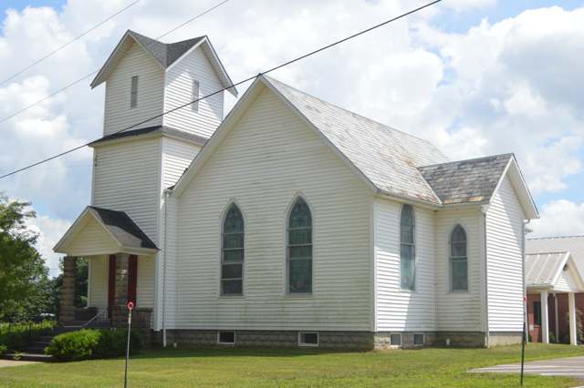
Photo: Nyttend, via Wikimedia Commons, public domain · Wikimedia Commons
Local history sources: archive.org · archive.org · en.wikipedia.org · en.wikipedia.org · en.wikipedia.org · commons.wikimedia.org
Water
Mostly private wells The water here
- Newark City58% of residentsNorth Fork Licking River
- Granville, Village Of21% of residentsGroundwater wells (3 wells)
- Johnstown City10% of residentsGroundwater wells (3 wells)
- Licking Regional Water District8% of residentsRaccoon Creek Valley aquifer (local wells)
- Del-co Water Company, Inc.1% of residentsOlentangy River, O'Shaughnessy and Alum Creek reservoirs, plus Knox County wells
- Alexandria Village1% of residentsGroundwater wells (3 wells)
- Licking County Prescott Estates0% of residentsGroundwater wells (3 wells)
- Lakeshore Court Mobile Home0% of residentsGroundwater wells (1 wells)
- Columbus Public Water System0% of residentsScioto River (Griggs & O'Shaughnessy), Hoover Reservoir on Big Walnut Ck, plus wells
- St. Louisville Village0% of residentsGroundwater wells (2 wells)
- City of Heath0% of residentslocal wells
- Winding Creek Estates0% of residentsGroundwater wells (1 wells)
- Valley Mobile Home Park0% of residentsGroundwater wells (2 wells)
- Wilkins Mobile Home Park0% of residentsGroundwater wells (2 wells)
- Green Meadows MHP0% of residentsGroundwater wells (2 wells)
Its ZIP codes
Each ZIP code that touches Mckean Township, Licking County, with the share of its residents who live here and the same headline figures as the ZIP page.
| ZIP | Share | Water | Radon | Home value | Schools | Flood |
|---|---|---|---|---|---|---|
| 43023 Granville | 4% | Mostly private wells | 10.0 pCi/L average radon | Median year built 1985 | Granville Exempted Village · 5 stars overall | 1.1% of residents in the 1% floodplain |
| 43031 Johnstown | 2% | Mostly private wells | 5.7 pCi/L average radon | Median year built 1991 | Johnstown-Monroe Local · 3.5 stars overall | 0.2% of residents in the 1% floodplain |
| 43001 Saint Albans Township and Alexandria | 1% | Mostly private wells | 8.9 pCi/L average radon | Median year built 1978 | Northridge Local · 4 stars overall | 3.3% of residents in the 1% floodplain |
| 43055 Newark | 1% | North Fork of the Licking River, drawn directly at riverbank intake screens beside the plant at the north end of Newark | 11.5 pCi/L average radon | Median year built 1960 | Newark City · 2.5 stars overall | 6.1% of residents in the 1% floodplain |
The county
Licking County: 17 ZIP codes, 38 cities, villages and townships, 160,939 people.
Nearby places
Cite this page
Cite this page as:
Cracked Buckeye (Open Shower Co), "Mckean Township, Licking County", https://crackedbuckeye.com/place/mckean-township-licking-county/, built 2026-09-16, accessed [date].
Machine-readable: /api/place/mckean-township-licking-county.json (open JSON, CC BY 4.0 for the compilation; the underlying records keep their own terms) · How to cite · Report a correction · Built 2026-09-16