How Harrison Township, Licking County began
Harrison Township was carved out of Union Township and organized in 1816, its earliest cabins going up around 1805-06 near the headwaters of the South Fork of the Licking, on ground that Mound Builders had marked with small burial mounds and that Native hunting parties -- probably based at the Wyandot village of Raccoon Town to the west -- had long used and crossed by trail. Settlement filled in slowly because much of the land was held by absentee speculators, then sped up once the National Road reached the township in the early 1830s, raising the village of Kirkersville (platted 1832 by Dr. William C. Kirker) and, once the Central Ohio Railroad came through, the depot hamlet later called Outville. The township's best-remembered pioneer set pieces are a communal wolf hunt in 1823 and years of seasonal squirrel hunts, while a Welsh-language Congregational church near the St. Albans line served an early Welsh settlement -- connected to Granville's Welsh Hills families -- for two generations before it was absorbed into English-speaking congregations. Today Harrison Township remains a mostly rural, increasingly suburbanizing township on Licking County's western edge.
Settled 1805-1806 (a Mr. Hatfield clears ground for cattle browse in the winter of 1805-06; Henry Drake builds a cabin in 1806), platted 1832 (Kirkersville, platted by Dr. William C. Kirker along the National Road), incorporated 1816 (township organized, taken from the territory of Union Township, with an added strip of Refugee-tract land giving it an outlet into Fairfield County).
Where the name comes from
No source consulted states why this township was named Harrison. It was organized in 1816, in the years after William Henry Harrison's Northwest campaigns in the War of 1812 made his name a common choice for new Ohio townships and communities, but no source found ties this particular naming decision to him directly.
Before the town
The 1881 county history records that Mound Builders were 'the first inhabitants in the shape and form of human beings to occupy this territory, so far as known,' leaving two small mounds -- twenty to thirty feet across and four or five feet high -- on what was called Refugee Road about half a mile north of Kirkersville; one was destroyed when the road was built and the other still stood as of 1881. Native people, the same source says, occupied the township only for hunting, fishing and trapping, with 'no permanent camp of these sons of the forest' known within its limits; the hunters were probably based at Raccoon Town, a Wyandot village a few miles west in what is now Monroe Township, whose land Euro-American settlers bought out in 1807. An Indian trail, not heavily used, crossed the township from the southeast along the South Fork of the Licking, understood by settlers to be the route Raccoon Town's people took on trips to fish at 'Little and Big lake' -- the shallow lakes and wetlands that later became the Licking County feeder reservoir (now Buckeye Lake). The origin of the settlements of neighboring Lima and Harrison townships is described in the same source as 'so nearly contemporary that the history of one is the history of the other.'
Nations recorded here: Wyandot.
- Refugee Road mounds (mound) — about half a mile north of Kirkersville, on Refugee Road, unspecified (Mound Builder era) (archive.org)
- Trail to Raccoon Town and the Reservoir (trail) — crossing the township from the southeast along the South Fork of the Licking, connecting toward Raccoon Town in Monroe Township, in use to at least the early 1800s (archive.org)
Timeline
- — A settler remembered only as Mr. Hatfield clears ground for cattle browse near the future site of Pataskala in the winter of 1805-06; Henry Drake, arriving from western Pennsylvania by way of Lancaster, Ohio, builds a cabin in the township in 1806.
- — Harrison Township is organized out of Union Township's territory, with a strip of Refugee-tract land added to its southeast corner to give it an outlet into Fairfield County.
- — A county-wide wolf hunt converges on a four-mile-square tract mostly within Harrison Township, ending with a bear, three wolves, forty-nine deer, sixty to seventy turkeys and one owl killed and divided among the hunters.
- — Kirkersville is platted along the National Road by Dr. William C. Kirker, who owned land at the mouth of Bloody Run on the South Fork.
- — Kirkersville's Presbyterian church, subscribed for in 1839, is finished and dedicated in March after several years of slow construction.
- — The census records Kirkersville's population at 349, with three or four stores, a hotel, three churches and a planing mill.
- — The Outville Depot, serving the railroad hamlet that grew up around Kirkersville's station two and a half miles from the village, is listed on the National Register of Historic Places.
- — The Outville Hay and Grain Company Building is listed on the National Register of Historic Places.
Stories
The Great Wolf Hunt of 1823
Pioneers in Harrison Township lost enough sheep and pigs to wolves that in 1823 the whole county organized to do something about it. County surveyor James Holmes laid out a four-mile-square tract, most of it inside Harrison Township, centered on a stretch of old 'deadened' woodland so thick with underbrush that men could barely walk through it. On the appointed morning a crowd gathered on the tract's east line -- 'no whiskey,' Holmes had insisted -- and slowly marched inward from all four sides, driving game before them as hornsmen signaled the advance. Deer and wild turkeys broke from the brush in droves, and a black bear was shot as it tried to slip past the closing line. When the hunters finally converged at the center, along Grass Lick creek, they had killed one bear, three wolves, forty-nine deer, sixty or seventy turkeys and one owl -- a haul divided by lot among three companies of men, with General Munson wrapping himself in the bearskin over his good coat for the walk home.
Hog Ward
In the early days, much of Harrison Township's woodland belonged to absentee owners and was left uncleared, making excellent range for stray hogs from farms as far off as Granville. One season, a farmer named John Ward, living west of Granville, found himself short of pork and helped himself to some of the free-ranging hogs he found in the Harrison Township woods. He picked good-looking animals and was in the middle of dressing them when their owners, alerted by word from Granville, arrived and found their own ear-marks on the carcasses. Ward was arrested, tried, and found guilty of hog-stealing; cooler heads talked the community out of a public whipping, but they settled instead on a punishment that lasted the rest of his life -- everyone simply started calling him 'Hog Ward.'
A Welsh Church on the Township Line
Nearly half a century before the 1881 county history was written, a number of Welsh families settled along the boundary between St. Albans and Harrison townships and organized themselves into the Welsh Congregational Church of Harrison, building a church where, for many years, services were conducted entirely in Welsh. Descendants of Theophilus Rees -- the same Deacon Rees who led the Welsh Hills settlers into neighboring Granville Township a generation earlier -- were among its original members. As the founding generation died out and their English-speaking children and grandchildren took their place, the congregation could no longer sustain Welsh-language worship, and it was gradually absorbed into the surrounding English churches until the organization went extinct. The church building itself was eventually sold and became private property.
Photographs
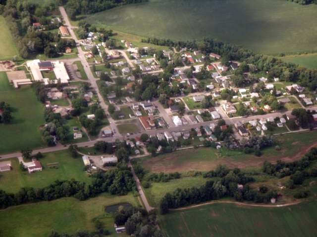
Photo: Ibagli, via Wikimedia Commons, public domain · Wikimedia Commons
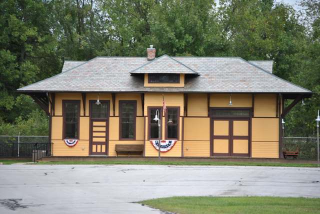
Photo: Wdzinc, via Wikimedia Commons, CC BY-SA 3.0 · Wikimedia Commons
Local history sources: archive.org · en.wikipedia.org · en.wikipedia.org · en.wikipedia.org · en.wikipedia.org · commons.wikimedia.org · commons.wikimedia.org
Water
Wells drawing from the Raccoon Creek Valley buried aquifer serving Etna, Pataskala, and Reynoldsburg-area customers The water here
- Licking Regional Water District69% of residentsRaccoon Creek Valley aquifer (local wells)
- Pataskala City20% of residentsSouth Fork Licking River Buried Valley Aquifer
- Granville, Village Of10% of residentsGroundwater wells (3 wells)
- Hebron Village1% of residentsGroundwater wells (4 wells)
- Millersport Village0% of residentsGroundwater wells (4 wells)
- Licking County Harbor Hills0% of residentsGroundwater wells (4 wells)
- Alexandria Village0% of residentsGroundwater wells (3 wells)
- Buckeye Lake, Village Of0% of residentsGroundwater wells (4 wells)
- Columbus Public Water System0% of residentsScioto River (Griggs & O'Shaughnessy), Hoover Reservoir on Big Walnut Ck, plus wells
- Roberts Trailer Park0% of residentsGroundwater wells (1 wells)
Its ZIP codes
Each ZIP code that touches Harrison Township, Licking County, with the share of its residents who live here and the same headline figures as the ZIP page.
The county
Licking County: 17 ZIP codes, 38 cities, villages and townships, 160,939 people.
Nearby places
Cite this page
Cite this page as:
Cracked Buckeye (Open Shower Co), "Harrison Township, Licking County", https://crackedbuckeye.com/place/harrison-township-licking-county/, built 2026-09-16, accessed [date].
Machine-readable: /api/place/harrison-township-licking-county.json (open JSON, CC BY 4.0 for the compilation; the underlying records keep their own terms) · How to cite · Report a correction · Built 2026-09-16