Fairfield Township, Columbiana County
Township · Columbiana County · 3,966 residents
Local events in Fairfield Township, Columbiana County
Nothing is posted for Fairfield Township itself yet; here is what is on within 10 miles. All local events in Fairfield Township, Columbiana County
Know a calendar we should watch? Send the link
Checked October 20; the events page is refreshed daily.
How Fairfield Township, Columbiana County began
Fairfield Township was organized in 1806, though its first permanent settler, Pennsylvania emigrant Mathias Lower, had already arrived by 1800; Lower's barn served as Columbiana County's first seat of government before a courthouse was built at New Lisbon. The township, which like several in Ohio straddles the county line into Mahoning County, holds the city of Columbiana in its north and the eastern edge of the village of Leetonia. Its best-documented historic property is the Hiram Bell Farmstead, an 1850 Greek Revival and Italianate brick house built by a local sawmill owner and future county commissioner, standing southwest of East Fairfield much as an 1879 county history illustrated it.
Settled 1800 (Mathias Lower), incorporated 1806 (township organized), by Mathias Lower (first settler); Columbiana County commissioners (township organization).
Where the name comes from
No source we reviewed documents the specific reasoning behind the township's name; Ohio has seven townships named Fairfield, a common descriptive name in the era's township-naming.
Before the town
No source we reviewed names a specific Native American village, camp or burial site within Fairfield Township's present boundaries. The township lies within the region ceded under the 1785 Treaty of Fort McIntosh and confirmed by the 1795 Treaty of Greenville. No township-specific site or encounter was found in the sources checked.
Timeline
- — Mathias Lower, an emigrant from Westmoreland County, Pennsylvania, becomes the area's first permanent settler.
- — Lower's barn in Fairfield Township serves briefly as the first seat of Columbiana County government before a courthouse is authorized at New Lisbon.
- — Fairfield Township is organized.
- — Hiram Bell builds the Greek Revival and Italianate brick house that becomes the Hiram Bell Farmstead, southwest of East Fairfield.
- — Hiram Bell operates a steam sawmill in neighboring Elkrun Township alongside his farm.
- — Hiram Bell takes office as a Columbiana County commissioner.
- — Horace Mack's History of Columbiana County, Ohio publishes an illustration of the Bell farmstead.
- — The Hiram Bell Farmstead, house and adjoining buildings, is listed on the National Register of Historic Places.
Stories
A barn that briefly ran the county
Before Columbiana County had a courthouse, it had Mathias Lower's barn. Lower, who had emigrated from Westmoreland County, Pennsylvania, and settled in what became Fairfield Township around 1800, offered his farm building as the meeting place for the first sessions of county government after Columbiana County organized in 1803 -- an arrangement common enough on the Ohio frontier, where a settler's outbuilding was often the largest covered space for miles. County business moved to New Lisbon soon after, once a $150 courthouse could be built there, but the fact that a county government briefly ran out of a Fairfield Township barn is one of the small, telling details county historians kept in the record.
A sawmill owner's brick house
Hiram Bell was born at his family's original homestead near East Fairfield and, by 1850, had done well enough as a farmer and businessman to build himself a substantial brick house combining Greek Revival and Italianate details -- a step up from the log construction most of his neighbors still lived in. Through the 1860s and 1870s he ran a steam sawmill in neighboring Elkrun Township alongside his farm operation, and in 1877 his standing in the county earned him a term as county commissioner. The house he built still stands southwest of East Fairfield, close enough to its original appearance that an artist's rendering published in Horace Mack's 1879 county history and a modern photograph of the same façade show recognizably the same building, a century and a half apart.
Photographs
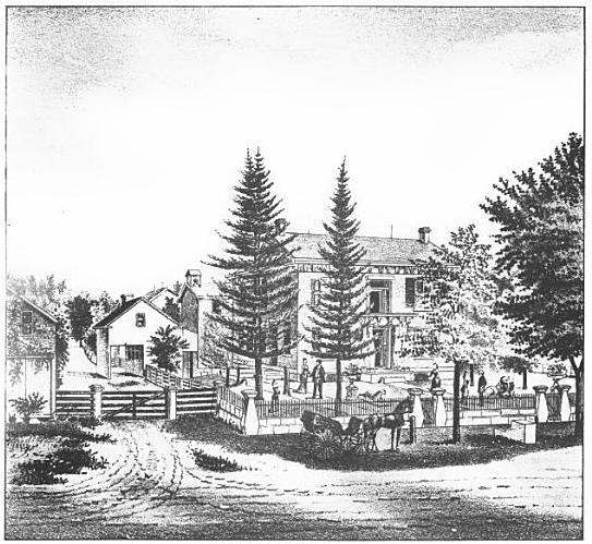
Photo: Unknown artist, from Horace Mack, History of Columbiana County, Ohio (1879), public domain · Wikimedia Commons
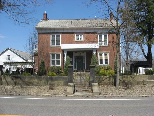
Photo: Nyttend (Wikimedia Commons), public domain · Wikimedia Commons
Local history sources: en.wikipedia.org · en.wikipedia.org · genealogytrails.com · commons.wikimedia.org · commons.wikimedia.org
Historic places
1 place in Fairfield Township, Columbiana County on the National Register of Historic Places. Press a pin or a name for its whole record.
-
Eckis, Nicholas, HouseBuilding · East Fairfield · listed 1980
- Address
- High St.
- Where
- East Fairfield, Columbiana County · ZIP 44445
- What it is
- Building
- Listed on the National Register
- 1980
- NRIS reference number
- 80002962
- Coordinates
- 40.82251, -80.63563
National Register file (NPS) ↗ Search Wikipedia ↗ Street map and directions ↗ On the Cracked Buckeye map
Source: National Park Service, National Register of Historic Places point file. The listing year is shown where NPS's certification date agrees with the listing's reference number. Listing recognizes significance; it does not restrict a private owner.
Water
Mostly private wells The water here
- Columbiana City68% of residentsGroundwater wells (11 wells)
- Leetonia Village22% of residentsEast Cold Run Reservoir & Spring Valley Reservoir (Cold Run Creek)
- New Waterford Village9% of residentsGroundwater wells (6 wells)
- Aqua Ohio - Struthers1% of residentsEvans Lake (Yellow Creek impoundment)
- Washingtonville Village0% of residentsEast Cold Run Reservoir & Spring Valley Reservoir (Cold Run Creek)
Hospitals, fire stations and more
Inside Fairfield Township, Columbiana County's boundary: 3 public schools, 39 shale and injection wells, 1 Superfund site, 4 Toxics Release Inventory facilities and 13 spill cases. Press a pin or a name for its whole record and its source.
Public schools (3)
-
Crestview Elementary School3.5 of 5 stars · Columbiana
- Address
- 3407 Middleton Rd, Columbiana, OH 44408
- School district
- Crestview Local School District
- Kind (NCES)
- Regular School
- Students, 2023-24
- 435
- Teachers (full-time equivalent)
- 26
- Report card, 2025-26
- 3.5 of 5 stars
- Performance index
- 83.3%
- Ohio building IRN
- 027003
- NCES school ID
- 390464302553
NCES school record ↗ Ohio School Report Card ↗ Street map and directions ↗
-
Crestview High School4.5 of 5 stars · Columbiana
- Address
- 44100 Crestview Rd Ste B, Columbiana, OH 44408
- School district
- Crestview Local School District
- Kind (NCES)
- Regular School
- Students, 2023-24
- 340
- Teachers (full-time equivalent)
- 23
- Report card, 2025-26
- 4.5 of 5 stars
- Performance index
- 82.7%
- Four-year graduation rate
- 100%
- Ohio building IRN
- 007658
- NCES school ID
- 390464302552
NCES school record ↗ Ohio School Report Card ↗ Street map and directions ↗
-
Crestview Middle School3.5 of 5 stars · Columbiana
- Address
- 44100 Crestview Rd Ste C, Columbiana, OH 44408
- School district
- Crestview Local School District
- Kind (NCES)
- Regular School
- Students, 2023-24
- 374
- Teachers (full-time equivalent)
- 22
- Report card, 2025-26
- 3.5 of 5 stars
- Performance index
- 81.9%
- Ohio building IRN
- 010983
- NCES school ID
- 390464302554
NCES school record ↗ Ohio School Report Card ↗ Street map and directions ↗
Source: NCES EDGE public school locations 2024-25 and Common Core of Data 2023-24 (type, students, teachers); Ohio School Report Cards 2025-26 (Department of Education and Workforce), matched by name within the district.
Shale and injection wells (39)
-
Fairfield Phoenix 1HUtica shale well · Drilling
- What it is
- Utica shale well
- Drilled sideways
- Yes
- Status (ODNR)
- Drilling
- Operator
- Hilcorp Energy Company
- County
- Columbiana County
- API well number
- 34029220370000
- Coordinates
- 40.84817, -80.66029
ODNR oil and gas wells (source) ↗ Street map and directions ↗
The point is the surface well head (the pad); a horizontal well runs a mile or more underground from it.
-
Fairfield Phoenix 2HUtica shale well · Drilling
- What it is
- Utica shale well
- Drilled sideways
- Yes
- Status (ODNR)
- Drilling
- Operator
- Hilcorp Energy Company
- County
- Columbiana County
- API well number
- 34029220380000
- Coordinates
- 40.84824, -80.66029
ODNR oil and gas wells (source) ↗ Street map and directions ↗
The point is the surface well head (the pad); a horizontal well runs a mile or more underground from it.
-
Fairfield Phoenix 3HUtica shale well · Drilling
- What it is
- Utica shale well
- Drilled sideways
- Yes
- Status (ODNR)
- Drilling
- Operator
- Hilcorp Energy Company
- County
- Columbiana County
- API well number
- 34029220390000
- Coordinates
- 40.84831, -80.66029
ODNR oil and gas wells (source) ↗ Street map and directions ↗
The point is the surface well head (the pad); a horizontal well runs a mile or more underground from it.
-
Fairfield Phoenix 4HUtica shale well · Drilling
- What it is
- Utica shale well
- Drilled sideways
- Yes
- Status (ODNR)
- Drilling
- Operator
- Hilcorp Energy Company
- County
- Columbiana County
- API well number
- 34029220420000
- Coordinates
- 40.84828, -80.66038
ODNR oil and gas wells (source) ↗ Street map and directions ↗
The point is the surface well head (the pad); a horizontal well runs a mile or more underground from it.
-
Fairfield Phoenix 5HUtica shale well · Drilling
- What it is
- Utica shale well
- Drilled sideways
- Yes
- Status (ODNR)
- Drilling
- Operator
- Hilcorp Energy Company
- County
- Columbiana County
- API well number
- 34029220430000
- Coordinates
- 40.84821, -80.66038
ODNR oil and gas wells (source) ↗ Street map and directions ↗
The point is the surface well head (the pad); a horizontal well runs a mile or more underground from it.
-
Fairfield Phoenix 6HUtica shale well · Well drilled
- What it is
- Utica shale well
- Drilled sideways
- Yes
- Status (ODNR)
- Well drilled
- Operator
- Hilcorp Energy Company
- County
- Columbiana County
- API well number
- 34029220350000
- Coordinates
- 40.84814, -80.66038
ODNR oil and gas wells (source) ↗ Street map and directions ↗
The point is the surface well head (the pad); a horizontal well runs a mile or more underground from it.
-
Fairfield Phoenix 7HUtica shale well · Well drilled
- What it is
- Utica shale well
- Drilled sideways
- Yes
- Status (ODNR)
- Well drilled
- Operator
- Hilcorp Energy Company
- County
- Columbiana County
- API well number
- 34029220360000
- Coordinates
- 40.84807, -80.66039
ODNR oil and gas wells (source) ↗ Street map and directions ↗
The point is the surface well head (the pad); a horizontal well runs a mile or more underground from it.
-
Fairfield Phoenix 8HUtica shale well · Well drilled
- What it is
- Utica shale well
- Drilled sideways
- Yes
- Status (ODNR)
- Well drilled
- Operator
- Hilcorp Energy Company
- County
- Columbiana County
- API well number
- 34029220330000
- Coordinates
- 40.84803, -80.66030
ODNR oil and gas wells (source) ↗ Street map and directions ↗
The point is the surface well head (the pad); a horizontal well runs a mile or more underground from it.
-
Fairfield Phoenix 9HUtica shale well · Well drilled
- What it is
- Utica shale well
- Drilled sideways
- Yes
- Status (ODNR)
- Well drilled
- Operator
- Hilcorp Energy Company
- County
- Columbiana County
- API well number
- 34029220340000
- Coordinates
- 40.84810, -80.66030
ODNR oil and gas wells (source) ↗ Street map and directions ↗
The point is the surface well head (the pad); a horizontal well runs a mile or more underground from it.
-
Fairfield Tarka 14HHorizontal shale well
- What it is
- Horizontal shale well
- Drilled sideways
- Yes
- Operator
- Hilcorp Energy Company
- County
- Columbiana County
- API well number
- 34029219400000
- Coordinates
- 40.83245, -80.67854
ODNR oil and gas wells (source) ↗ Street map and directions ↗
The point is the surface well head (the pad); a horizontal well runs a mile or more underground from it.
-
Fairfield Unkefer 10HUtica shale well
- What it is
- Utica shale well
- Drilled sideways
- Yes
- Operator
- Hilcorp Energy Company
- County
- Columbiana County
- API well number
- 34029219970000
- Coordinates
- 40.82338, -80.69238
ODNR oil and gas wells (source) ↗ Street map and directions ↗
The point is the surface well head (the pad); a horizontal well runs a mile or more underground from it.
-
Fairfield Unkefer 3HUtica shale well
- What it is
- Utica shale well
- Drilled sideways
- Yes
- Operator
- Hilcorp Energy Company
- County
- Columbiana County
- API well number
- 34029219910000
- Coordinates
- 40.82323, -80.69249
ODNR oil and gas wells (source) ↗ Street map and directions ↗
The point is the surface well head (the pad); a horizontal well runs a mile or more underground from it.
-
Fairfield Unkefer 4HUtica shale well
- What it is
- Utica shale well
- Drilled sideways
- Yes
- Operator
- Hilcorp Energy Company
- County
- Columbiana County
- API well number
- 34029219920000
- Coordinates
- 40.82319, -80.69249
ODNR oil and gas wells (source) ↗ Street map and directions ↗
The point is the surface well head (the pad); a horizontal well runs a mile or more underground from it.
-
Fairfield Unkefer 5HUtica shale well
- What it is
- Utica shale well
- Drilled sideways
- Yes
- Operator
- Hilcorp Energy Company
- County
- Columbiana County
- API well number
- 34029219930000
- Coordinates
- 40.82321, -80.69239
ODNR oil and gas wells (source) ↗ Street map and directions ↗
The point is the surface well head (the pad); a horizontal well runs a mile or more underground from it.
-
Fairfield Unkefer 6HUtica shale well
- What it is
- Utica shale well
- Drilled sideways
- Yes
- Operator
- Hilcorp Energy Company
- County
- Columbiana County
- API well number
- 34029219950000
- Coordinates
- 40.82325, -80.69239
ODNR oil and gas wells (source) ↗ Street map and directions ↗
The point is the surface well head (the pad); a horizontal well runs a mile or more underground from it.
-
Fairfield Unkefer 7HUtica shale well
- What it is
- Utica shale well
- Drilled sideways
- Yes
- Operator
- Hilcorp Energy Company
- County
- Columbiana County
- API well number
- 34029219940000
- Coordinates
- 40.82332, -80.69249
ODNR oil and gas wells (source) ↗ Street map and directions ↗
The point is the surface well head (the pad); a horizontal well runs a mile or more underground from it.
-
Fairfield Unkefer 8HUtica shale well
- What it is
- Utica shale well
- Drilled sideways
- Yes
- Operator
- Hilcorp Energy Company
- County
- Columbiana County
- API well number
- 34029219960000
- Coordinates
- 40.82336, -80.69249
ODNR oil and gas wells (source) ↗ Street map and directions ↗
The point is the surface well head (the pad); a horizontal well runs a mile or more underground from it.
-
Fairfield Unkefer 9HUtica shale well
- What it is
- Utica shale well
- Drilled sideways
- Yes
- Operator
- Hilcorp Energy Company
- County
- Columbiana County
- API well number
- 34029219980000
- Coordinates
- 40.82340, -80.69249
ODNR oil and gas wells (source) ↗ Street map and directions ↗
The point is the surface well head (the pad); a horizontal well runs a mile or more underground from it.
-
Fairfield-Nolker 7HUtica shale well
- What it is
- Utica shale well
- Drilled sideways
- Yes
- Operator
- Hilcorp Energy Company
- County
- Columbiana County
- API well number
- 34029218610000
- Coordinates
- 40.84384, -80.73018
ODNR oil and gas wells (source) ↗ Street map and directions ↗
The point is the surface well head (the pad); a horizontal well runs a mile or more underground from it.
-
Fairfield-Nolker 9HUtica shale well
- What it is
- Utica shale well
- Drilled sideways
- Yes
- Operator
- Hilcorp Energy Company
- County
- Columbiana County
- API well number
- 34029218690000
- Coordinates
- 40.84385, -80.73028
ODNR oil and gas wells (source) ↗ Street map and directions ↗
The point is the surface well head (the pad); a horizontal well runs a mile or more underground from it.
-
Fairfield-Tarka 10HUtica shale well
- What it is
- Utica shale well
- Drilled sideways
- Yes
- Operator
- Hilcorp Energy Company
- County
- Columbiana County
- API well number
- 34029219390000
- Coordinates
- 40.83245, -80.67838
ODNR oil and gas wells (source) ↗ Street map and directions ↗
The point is the surface well head (the pad); a horizontal well runs a mile or more underground from it.
-
Fairfield-Tarka 11HUtica shale well
- What it is
- Utica shale well
- Drilled sideways
- Yes
- Operator
- Hilcorp Energy Company
- County
- Columbiana County
- API well number
- 34029219320000
- Coordinates
- 40.83245, -80.67833
ODNR oil and gas wells (source) ↗ Street map and directions ↗
The point is the surface well head (the pad); a horizontal well runs a mile or more underground from it.
-
Fairfield-Tarka 12HUtica shale well
- What it is
- Utica shale well
- Drilled sideways
- Yes
- Operator
- Hilcorp Energy Company
- County
- Columbiana County
- API well number
- 34029219330000
- Coordinates
- 40.83245, -80.67827
ODNR oil and gas wells (source) ↗ Street map and directions ↗
The point is the surface well head (the pad); a horizontal well runs a mile or more underground from it.
-
Fairfield-Tarka 13HUtica shale well
- What it is
- Utica shale well
- Drilled sideways
- Yes
- Operator
- Hilcorp Energy Company
- County
- Columbiana County
- API well number
- 34029219340000
- Coordinates
- 40.83245, -80.67822
ODNR oil and gas wells (source) ↗ Street map and directions ↗
The point is the surface well head (the pad); a horizontal well runs a mile or more underground from it.
-
Fairfield-Tarka 1HUtica shale well
- What it is
- Utica shale well
- Drilled sideways
- Yes
- Operator
- Hilcorp Energy Company
- County
- Columbiana County
- API well number
- 34029219230000
- Coordinates
- 40.83236, -80.67849
ODNR oil and gas wells (source) ↗ Street map and directions ↗
The point is the surface well head (the pad); a horizontal well runs a mile or more underground from it.
-
Fairfield-Tarka 2HUtica shale well
- What it is
- Utica shale well
- Drilled sideways
- Yes
- Operator
- Hilcorp Energy Company
- County
- Columbiana County
- API well number
- 34029219240000
- Coordinates
- 40.83236, -80.67844
ODNR oil and gas wells (source) ↗ Street map and directions ↗
The point is the surface well head (the pad); a horizontal well runs a mile or more underground from it.
-
Fairfield-Tarka 3HUtica shale well
- What it is
- Utica shale well
- Drilled sideways
- Yes
- Operator
- Hilcorp Energy Company
- County
- Columbiana County
- API well number
- 34029219250000
- Coordinates
- 40.83236, -80.67838
ODNR oil and gas wells (source) ↗ Street map and directions ↗
The point is the surface well head (the pad); a horizontal well runs a mile or more underground from it.
-
Fairfield-Tarka 5HUtica shale well
- What it is
- Utica shale well
- Drilled sideways
- Yes
- Operator
- Hilcorp Energy Company
- County
- Columbiana County
- API well number
- 34029219260000
- Coordinates
- 40.83237, -80.67827
ODNR oil and gas wells (source) ↗ Street map and directions ↗
The point is the surface well head (the pad); a horizontal well runs a mile or more underground from it.
-
Fairfield-Tarka 6HUtica shale well
- What it is
- Utica shale well
- Drilled sideways
- Yes
- Operator
- Hilcorp Energy Company
- County
- Columbiana County
- API well number
- 34029219270000
- Coordinates
- 40.83237, -80.67822
ODNR oil and gas wells (source) ↗ Street map and directions ↗
The point is the surface well head (the pad); a horizontal well runs a mile or more underground from it.
-
Fairfield-Tarka 7HUtica shale well
- What it is
- Utica shale well
- Drilled sideways
- Yes
- Operator
- Hilcorp Energy Company
- County
- Columbiana County
- API well number
- 34029219280000
- Coordinates
- 40.83237, -80.67816
ODNR oil and gas wells (source) ↗ Street map and directions ↗
The point is the surface well head (the pad); a horizontal well runs a mile or more underground from it.
-
Fairfield-Tarka 8HUtica shale well
- What it is
- Utica shale well
- Drilled sideways
- Yes
- Operator
- Hilcorp Energy Company
- County
- Columbiana County
- API well number
- 34029219290000
- Coordinates
- 40.83245, -80.67849
ODNR oil and gas wells (source) ↗ Street map and directions ↗
The point is the surface well head (the pad); a horizontal well runs a mile or more underground from it.
-
Fairfield-Tarka 9HUtica shale well
- What it is
- Utica shale well
- Drilled sideways
- Yes
- Operator
- Hilcorp Energy Company
- County
- Columbiana County
- API well number
- 34029219300000
- Coordinates
- 40.83244, -80.67844
ODNR oil and gas wells (source) ↗ Street map and directions ↗
The point is the surface well head (the pad); a horizontal well runs a mile or more underground from it.
-
Fairfield-Unkefer 13HUtica shale well
- What it is
- Utica shale well
- Drilled sideways
- Yes
- Operator
- Hilcorp Energy Company
- County
- Columbiana County
- API well number
- 34029218870000
- Coordinates
- 40.82342, -80.69239
ODNR oil and gas wells (source) ↗ Street map and directions ↗
The point is the surface well head (the pad); a horizontal well runs a mile or more underground from it.
-
Fairfield-Unkefer 14HUtica shale well
- What it is
- Utica shale well
- Drilled sideways
- Yes
- Operator
- Hilcorp Energy Company
- County
- Columbiana County
- API well number
- 34029218860000
- Coordinates
- 40.82346, -80.69239
ODNR oil and gas wells (source) ↗ Street map and directions ↗
The point is the surface well head (the pad); a horizontal well runs a mile or more underground from it.
-
Fairfield-Unkefer 1HUtica shale well
- What it is
- Utica shale well
- Drilled sideways
- Yes
- Operator
- Hilcorp Energy Company
- County
- Columbiana County
- API well number
- 34029218850000
- Coordinates
- 40.82317, -80.69239
ODNR oil and gas wells (source) ↗ Street map and directions ↗
The point is the surface well head (the pad); a horizontal well runs a mile or more underground from it.
-
Fairfield-Unkefer 2HUtica shale well
- What it is
- Utica shale well
- Drilled sideways
- Yes
- Operator
- Hilcorp Energy Company
- County
- Columbiana County
- API well number
- 34029219900000
- Coordinates
- 40.82329, -80.69239
ODNR oil and gas wells (source) ↗ Street map and directions ↗
The point is the surface well head (the pad); a horizontal well runs a mile or more underground from it.
-
Hartz 18-12-2 1HUtica shale well
- What it is
- Utica shale well
- Drilled sideways
- Yes
- Operator
- Eog Ohio, Llc
- County
- Columbiana County
- API well number
- 34029217570000
- Coordinates
- 40.86079, -80.74527
ODNR oil and gas wells (source) ↗ Street map and directions ↗
The point is the surface well head (the pad); a horizontal well runs a mile or more underground from it.
-
Lehman 24-12-2 8HUtica shale well
- What it is
- Utica shale well
- Drilled sideways
- Yes
- Operator
- Pin Oak Energy Partners Llc
- County
- Columbiana County
- API well number
- 34029217490000
- Coordinates
- 40.84831, -80.64495
ODNR oil and gas wells (source) ↗ Street map and directions ↗
The point is the surface well head (the pad); a horizontal well runs a mile or more underground from it.
-
Mellinger 7-12-2 8HUtica shale well
- What it is
- Utica shale well
- Drilled sideways
- Yes
- Operator
- Eog Ohio, Llc
- County
- Columbiana County
- API well number
- 34029217210100
- Coordinates
- 40.87288, -80.74048
ODNR oil and gas wells (source) ↗ Street map and directions ↗
The point is the surface well head (the pad); a horizontal well runs a mile or more underground from it.
Source: ODNR Division of Oil and Gas Resources well inventory (September 2026): drilled Utica, Marcellus and horizontal wells and Class II injection wells not plugged. Older vertical wells are on the full map.
Superfund sites (1)
-
Leetonia Mercury ResponseSuperfund program · Leetonia
- Address
- 40085 Crestview Rd, Leetonia, OH 44431
- County
- -- Not Defined -- County
- Status
- Superfund program site, not on the National Priorities List
- EPA program ID
- OHN000522045
- EPA registry ID
- 110071732459
EPA facility record ↗ EPA Facility Registry Service (source) ↗ Street map and directions ↗
Source: EPA Facility Registry Service, Superfund (SEMS) and National Priorities List sites. Many program sites were assessed and needed no cleanup.
Facilities reporting toxic releases (4)
-
Buckeye Transfer IncToxics Release Inventory · Columbiana
- Address
- 41738 Esterly Dr, Columbiana, OH 44408
- County
- Columbiana County
- Status
- Reports to the Toxics Release Inventory (active)
- EPA program ID
- 44408NTNLR41738
- EPA registry ID
- 110000389598
EPA facility record ↗ EPA Facility Registry Service (source) ↗ Street map and directions ↗
-
Humtown Pattern CoToxics Release Inventory · Columbiana
- Address
- 44708 Columbiana Waterford Road, Columbiana, OH 44408
- County
- Columbiana County
- Status
- Reports to the Toxics Release Inventory (active)
- EPA program ID
- 44408HMTWN44708
- EPA registry ID
- 110001619712
EPA facility record ↗ EPA Facility Registry Service (source) ↗ Street map and directions ↗
-
Specialty Ceramics IncToxics Release Inventory · Columbiana
- Address
- 41995 State Route 344, Columbiana, OH 44408
- County
- Columbiana County
- Status
- Reports to the Toxics Release Inventory (active)
- EPA program ID
- 44460SPCLT1801S
- EPA registry ID
- 110005970994
EPA facility record ↗ EPA Facility Registry Service (source) ↗ Street map and directions ↗
-
United States Can CompanyToxics Release Inventory · Columbiana
- Address
- 41969 West Park Avenue, Columbiana, OH 44408
- County
- Columbiana County
- Status
- Reports to the Toxics Release Inventory (closed)
- EPA program ID
- 44408BLLNFWPARK
- EPA registry ID
- 110007157174
EPA facility record ↗ EPA Facility Registry Service (source) ↗ Street map and directions ↗
Source: EPA Facility Registry Service, Toxics Release Inventory reporters. Reporting a release is required of large users of listed chemicals; it is not by itself a violation.
Spills reported since 2021 (13)
-
Fuel Diesel / Diesel Fuel (Vehicle On Or Off Road)2024-11-21 · Fairfield Twp
- Reported
- 2024-11-21
- What spilled
- Fuel Diesel / Diesel Fuel (Vehicle On Or Off Road)
- Largest amount reported
- 100 gallons
- Where
- Fairfield Twp, Columbiana County
- Ohio EPA district office
- NEDO
- Ohio EPA case number
- 2411EPA0001919
Ohio EPA spill reports (source) ↗ Street map and directions ↗
-
Other / All Other / Trade Name / Mixture / Solution Etc2024-04-09 · Fairfield Twp
- Reported
- 2024-04-09
- What spilled
- Other / All Other / Trade Name / Mixture / Solution Etc
- Where
- Fairfield Twp, Columbiana County
- Ohio EPA district office
- NEDO
- Ohio EPA case number
- 2404EPA0000566
Ohio EPA spill reports (source) ↗ Street map and directions ↗
-
Natural Gas2024-03-26 · Fairfield Twp
- Reported
- 2024-03-26
- What spilled
- Natural Gas
- Where
- Fairfield Twp, Columbiana County
- Ohio EPA district office
- NEDO
- Ohio EPA case number
- 2403EPA0000472
Ohio EPA spill reports (source) ↗ Street map and directions ↗
-
Natural Gas2023-07-11 · Fairfield Twp
- Reported
- 2023-07-11
- What spilled
- Natural Gas
- Where
- Fairfield Twp, Columbiana County
- Ohio EPA district office
- NEDO
- Ohio EPA case number
- 2307EPA0001150
Ohio EPA spill reports (source) ↗ Street map and directions ↗
-
Hydrogen Peroxide (H2O2)2023-05-25 · Columbiana
- Reported
- 2023-05-25
- What spilled
- Hydrogen Peroxide (H2O2)
- Largest amount reported
- 10 gallons
- Where
- Columbiana, Columbiana County
- Ohio EPA district office
- NEDO
- Ohio EPA case number
- 2305EPA0000861
Ohio EPA spill reports (source) ↗ Street map and directions ↗
-
Oil Transformer Non Pcb2023-03-03 · Fairfield Twp
- Reported
- 2023-03-03
- What spilled
- Oil Transformer Non Pcb
- Largest amount reported
- 100 gallons
- Where
- Fairfield Twp, Columbiana County
- Ohio EPA district office
- NEDO
- Ohio EPA case number
- 2303EPA0000327
Ohio EPA spill reports (source) ↗ Street map and directions ↗
-
Vinyl Acetate (C4H6O2)2023-03-03 · Columbiana
- Reported
- 2023-03-03
- What spilled
- Vinyl Acetate (C4H6O2)
- Where
- Columbiana, Columbiana County
- Ohio EPA district office
- NEDO
- Ohio EPA case number
- 2303EPA0000326
Ohio EPA spill reports (source) ↗ Street map and directions ↗
-
Other / All Other / Trade Name / Mixture / Solution Etc2022-10-30 · Fairfield Twp
- Reported
- 2022-10-30
- What spilled
- Other / All Other / Trade Name / Mixture / Solution Etc
- Where
- Fairfield Twp, Columbiana County
- Ohio EPA district office
- NEDO
- Ohio EPA case number
- 2210EPA0001620
Ohio EPA spill reports (source) ↗ Street map and directions ↗
-
Oil Motor / Lube Oil / Vehicle Reached water2022-01-29 · Fairfield Twp
- Reported
- 2022-01-29
- What spilled
- Oil Motor / Lube Oil / Vehicle
- Reached a waterway
- 99 - Unnamed
- Where
- Fairfield Twp, Columbiana County
- Ohio EPA district office
- NEDO
- Ohio EPA case number
- 2201EPA0000090
Ohio EPA spill reports (source) ↗ Street map and directions ↗
-
Material Unknown2021-03-14 · Fairfield Twp
- Reported
- 2021-03-14
- What spilled
- Material Unknown
- Where
- Fairfield Twp, Columbiana County
- Ohio EPA district office
- NEDO
- Ohio EPA case number
- 2103EPA0000335
Ohio EPA spill reports (source) ↗ Street map and directions ↗
-
Waste Water Reached water2021-01-06 · Fairfield Twp
- Reported
- 2021-01-06
- What spilled
- Waste Water
- Largest amount reported
- 480 gallons
- Reached a waterway
- 99 - Unnamed
- Where
- Fairfield Twp, Columbiana County
- Ohio EPA district office
- NEDO
- Ohio EPA case number
- 2101EPA0000017
Ohio EPA spill reports (source) ↗ Street map and directions ↗
-
Other / All Other / Trade Name / Mixture / Solution Etc2026-06-17 · Columbiana
- Reported
- 2026-06-17
- What spilled
- Other / All Other / Trade Name / Mixture / Solution Etc
- Largest amount reported
- 260 gallons
- Where
- Columbiana, Columbiana County
- Ohio EPA district office
- NEDO
- Ohio EPA case number
- 2606EPA0001076
Ohio EPA spill reports (source) ↗ Street map and directions ↗
-
Oil Transformer Non Pcb2026-03-14 · Fairfield Twp
- Reported
- 2026-03-14
- What spilled
- Oil Transformer Non Pcb
- Largest amount reported
- 80 gallons
- Where
- Fairfield Twp, Columbiana County
- Ohio EPA district office
- NEDO
- Ohio EPA case number
- 2603EPA0000380
Ohio EPA spill reports (source) ↗ Street map and directions ↗
Source: Ohio EPA emergency response spill reports, 2021 to September 2026, one point per case where Ohio EPA placed it. A report is what the caller or responder recorded; amounts are often blank or estimated.
Its ZIP codes
Each ZIP code that touches Fairfield Township, Columbiana County, with the share of its residents who live here and the same headline figures as the ZIP page.
| ZIP | Share | Water | Radon | Home value | Schools | Flood |
|---|---|---|---|---|---|---|
| 44431 Leetonia | 27% | Mostly private wells | 20.5 pCi/L average radon | Appraisal records without year built | Leetonia Exempted Village · 3 stars overall | 4.1% of residents in the 1% floodplain |
| 44408 Columbiana | 21% | Groundwater wells (11 wells) | 4.5 pCi/L average radon | Appraisal records without year built | Columbiana Exempted Village · 5 stars overall | 1.8% of residents in the 1% floodplain |
| 44445 Unity Township and New Waterford | 15% | Mostly private wells | 7.0 pCi/L average radon | Appraisal records without year built | Crestview Local · 4 stars overall | 1.9% of residents in the 1% floodplain |
Local government
Who holds office in Fairfield Township, Columbiana County, how its elections and ballot issues came out, and the state auditor's record.
Money issues on the ballot since 2021: 2 of 2 passed.
Ballot issues
| Date | Issue | For | Against | Result |
|---|---|---|---|---|
| 2022-11-08 | Issue: Fairfield Township Tax Levy Fire District | 1,243 | 452 | Passed (73.33% for) |
| 2021-11-02 | Issue: Fairfield Twp Tax Levy Roads | 665 | 254 | Passed (72.36% for) |
Elections for office
| Date | Office | Candidates and votes |
|---|---|---|
| 2023-11-07 | Township Trustee | Logan Cope 993, 29.38%; John S. Garwood 2,387, 70.62% |
| 2023-11-07 | Township Fiscal Officer | Write-In: Adam Booth 143, 64.71% |
| 2021-11-02 | Township Trustee | Bob Hum 683, 51.12%; Barry A. Miner 653, 48.88% |
Winners in bold. Results from the county board of elections' official canvass unless marked.
Auditor of State record
- No fiscal caution, watch or emergency on the Auditor of State's lists.
- Financial Audit, 2022 to 2023, released 2024-10-15
The county
Columbiana County: 20 ZIP codes, 33 cities, villages and townships, 106,075 people.
Nearby places
Quick answers
What county is Fairfield Township, Ohio in?
Fairfield Township, Columbiana County is a township in Columbiana County, Ohio, with 3,966 residents.
When was Fairfield Township, Ohio founded?
Fairfield Township, Columbiana County was settled 1800 (Mathias Lower); incorporated 1806 (township organized). Founders on record: Mathias Lower (first settler); Columbiana County commissioners (township organization). Source
What ZIP code is Fairfield Township, Ohio?
Fairfield Township, Columbiana County is served by ZIP codes 44431, 44408 and 44445; 44431 holds the largest share of its residents.
Where does Fairfield Township, Ohio get its water?
The main water source for Fairfield Township, Columbiana County (Columbiana City): Mostly private wells.
Cite this page
Cite this page as:
Cracked Buckeye, "Fairfield Township, Columbiana County", https://crackedbuckeye.com/place/fairfield-township-columbiana-county/, built 2026-10-31, accessed [date].
How to cite · Report a correction · Built 2026-10-31
