Local events in Elkrun Township, Columbiana County
Nothing is posted for Elkrun Township itself yet; here is what is on within 10 miles. All local events in Elkrun Township, Columbiana County
Know a calendar we should watch? Send the link
Checked October 20; the events page is refreshed daily.
How Elkrun Township, Columbiana County began
Elkrun Township, in eastern Columbiana County, was organized in 1806, Ohio's only township of that name, centered on the small community of Elkton with Signal to the northeast and the eastern edge of the county seat, Lisbon, along its western border. Its best-documented historic landmark is the Church Hill Road Covered Bridge, an 1870 single-kingpost span so short -- just over 19 feet -- that it ranks among the smallest public-highway covered bridges in the country; it was moved from its original crossing of the Middle Fork of Little Beaver Creek to its present roadside site in 1982. The Federal Correctional Institution, Elkton, a low-security federal prison, opened in the township in 1997.
Settled early 1800s, incorporated 1806 (township organized), by Columbiana County commissioners.
Where the name comes from
The reason for the name is not recorded. It is the only Elkrun Township in Ohio, though the state has separate Elk townships in Noble and Vinton counties.
Before the town
No Native American village, camp or burial site is recorded within Elkrun Township's present boundaries. The township lies within the region ceded under the 1785 Treaty of Fort McIntosh and confirmed by the 1795 Treaty of Greenville, opened afterward to the Seven Ranges survey and to settlement.
Timeline
- — John Cannon settles in the southeast part of section 26 about this year or earlier and soon sets pioneer mills going on the Middle Beaver; he runs them until 1836, when he sells to the canal company, and a gristmill in section 36 is worked from 1812 until the canal destroys the mill-site.
- — Elkrun Township is organized in eastern Columbiana County.
- — A tax of $47.50 is levied on the township's personal property to defray county expenses, the year after its organization.
- — After this year the population of Elk Run increases rapidly, and many of the newcomers become permanent residents.
- — William Green and John Whan open the first coal banks in the western part of the township; William Orr begins mining on a larger scale about 1848, producing 30,000 bushels a year, mostly sold at New Lisbon.
- — On April 30 the county surveyor J. G. Williard plats Elkton for William Kemble, on Beaver Creek near the center of section 21, with a single 50-foot street called Canal Street; Kemble builds a large frame house and a canal warehouse there that year.
- — A post office is established at Elkton about this year with George Kemble as first postmaster; the village reaches its largest size, about twenty-five houses, around 1848.
- — The Sandy and Beaver Canal, which has fourteen locks and dams in the township, opens along the north bank of the Middle Beaver.
- — Christian Bowman sets out a 13-acre apple orchard, followed four years later by a ten-acre second orchard; peaches are also widely grown.
- — Chauncy Andrews and Company of Youngstown lease several thousand acres in the western part of the township and open a coal mine near William Orr's old works in section 18; the Niles and New Lisbon Railroad lays a spur, and 40 to 60 miners work it for five or six years.
- — The Church Hill Road Covered Bridge is built over the Middle Fork of Little Beaver Creek, a 19-foot-3-inch single-kingpost span.
- — Elkrun Township leads the county in beehives, with 40 of the county's 248 hives, and is third in honey production.
- — The Church Hill Road Covered Bridge is listed on the National Register of Historic Places.
- — The covered bridge is relocated from its original creek crossing to a roadside site on State Route 154 near Elkton.
- — The Federal Correctional Institution, Elkton, a low-security federal prison, opens in the township.
- — The census counts 4,367 people in Elkrun Township.
Stories
One of the shortest covered bridges in the country
Built in 1870 to carry a local road over the Middle Fork of Little Beaver Creek, the Church Hill Road Covered Bridge is a two-panel single-kingpost span measuring just 19 feet 3 inches -- among the shortest covered bridges built for public highway use anywhere in the United States. It was listed on the National Register of Historic Places in June 1975, and in 1982 it was picked up and moved to a new site along State Route 154 near Elkton, behind what was then a roadside restaurant, where it still stands.
The canal village that wasn't
Before the Sandy and Beaver Canal was built through the township, Edward Crawford platted a tract on section 36 as a village called Middle Beaver, opened a store, and sold lots on which a few small houses were built. The county historians judged the place badly sited and shadowed by a rival, Williamsport, a short distance down the stream in Madison Township; when the canal that was to give it life was abandoned, every hope for the town ended, the lots and streets were vacated, and Middle Beaver became part of an ordinary farm. Elkton, platted in 1835 farther up the creek, had a happier course for a few years: its one street was named Canal Street after the waterway and its warehouse stood beside it, and by about 1848 it had as many buildings as it did thirty years later. The canal company's fourteen locks and dams in the township were, in 1879, still in excellent condition in places.
Photographs
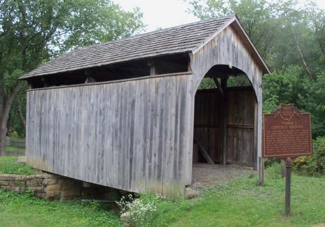
Photo: Roseohioresident (Wikimedia Commons), CC BY-SA 3.0 · Wikimedia Commons
Local history sources: en.wikipedia.org · en.wikipedia.org · en.wikipedia.org · commons.wikimedia.org · archive.org · archive.org
Historic places
1 place in Elkrun Township, Columbiana County on the National Register of Historic Places. Press a pin or a name for its whole record.
-
Church Hill Road Covered BridgeStructure · Lisbon · listed 1975
- Address
- 3 mi. E of Lisbon off SR 867
- Where
- Lisbon, Columbiana County · ZIP 44432
- What it is
- Structure
- Listed on the National Register
- 1975
- NRIS reference number
- 75001347
- Coordinates
- 40.78717, -80.72459
National Register file (NPS) ↗ Search Wikipedia ↗ Street map and directions ↗ On the Cracked Buckeye map
Source: National Park Service, National Register of Historic Places point file. The listing year is shown where NPS's certification date agrees with the listing's reference number. Listing recognizes significance; it does not restrict a private owner.
Water
Mostly private wells The water here
- Lisbon Village94% of residentsGroundwater wells (6 wells)
- New Waterford Village4% of residentsGroundwater wells (6 wells)
- Leetonia Village2% of residentsEast Cold Run Reservoir & Spring Valley Reservoir (Cold Run Creek)
- Columbiana County-county Home Rd0% of residentsEast Cold Run Reservoir & Spring Valley Reservoir (Cold Run Creek)
- Washingtonville Village0% of residentsEast Cold Run Reservoir & Spring Valley Reservoir (Cold Run Creek)
Hospitals, fire stations and more
Inside Elkrun Township, Columbiana County's boundary: 66 shale and injection wells, 1 Superfund site, 1 Toxics Release Inventory facility and 4 spill cases. Press a pin or a name for its whole record and its source.
Shale and injection wells (66)
-
Elkrun Fairmont 10HHorizontal shale well
- What it is
- Horizontal shale well
- Drilled sideways
- Yes
- Operator
- Hilcorp Energy Company
- County
- Columbiana County
- API well number
- 34029219730000
- Coordinates
- 40.76819, -80.67484
ODNR oil and gas wells (source) ↗ Street map and directions ↗
The point is the surface well head (the pad); a horizontal well runs a mile or more underground from it.
-
Elkrun Fairmont 1HHorizontal shale well
- What it is
- Horizontal shale well
- Drilled sideways
- Yes
- Operator
- Hilcorp Energy Company
- County
- Columbiana County
- API well number
- 34029219640000
- Coordinates
- 40.76811, -80.67497
ODNR oil and gas wells (source) ↗ Street map and directions ↗
The point is the surface well head (the pad); a horizontal well runs a mile or more underground from it.
-
Elkrun Fairmont 2HHorizontal shale well
- What it is
- Horizontal shale well
- Drilled sideways
- Yes
- Operator
- Hilcorp Energy Company
- County
- Columbiana County
- API well number
- 34029219650000
- Coordinates
- 40.76816, -80.67488
ODNR oil and gas wells (source) ↗ Street map and directions ↗
The point is the surface well head (the pad); a horizontal well runs a mile or more underground from it.
-
Elkrun Fairmont 3HHorizontal shale well
- What it is
- Horizontal shale well
- Drilled sideways
- Yes
- Operator
- Hilcorp Energy Company
- County
- Columbiana County
- API well number
- 34029219660000
- Coordinates
- 40.76822, -80.67480
ODNR oil and gas wells (source) ↗ Street map and directions ↗
The point is the surface well head (the pad); a horizontal well runs a mile or more underground from it.
-
Elkrun Fairmont 5HHorizontal shale well
- What it is
- Horizontal shale well
- Drilled sideways
- Yes
- Operator
- Hilcorp Energy Company
- County
- Columbiana County
- API well number
- 34029219680000
- Coordinates
- 40.76816, -80.67506
ODNR oil and gas wells (source) ↗ Street map and directions ↗
The point is the surface well head (the pad); a horizontal well runs a mile or more underground from it.
-
Elkrun Fairmont 6HHorizontal shale well
- What it is
- Horizontal shale well
- Drilled sideways
- Yes
- Operator
- Hilcorp Energy Company
- County
- Columbiana County
- API well number
- 34029219690000
- Coordinates
- 40.76819, -80.67502
ODNR oil and gas wells (source) ↗ Street map and directions ↗
The point is the surface well head (the pad); a horizontal well runs a mile or more underground from it.
-
Elkrun Fairmont 7HHorizontal shale well
- What it is
- Horizontal shale well
- Drilled sideways
- Yes
- Operator
- Hilcorp Energy Company
- County
- Columbiana County
- API well number
- 34029219700000
- Coordinates
- 40.76821, -80.67497
ODNR oil and gas wells (source) ↗ Street map and directions ↗
The point is the surface well head (the pad); a horizontal well runs a mile or more underground from it.
-
Elkrun Fairmont 8HUtica shale well
- What it is
- Utica shale well
- Drilled sideways
- Yes
- Operator
- Hilcorp Energy Company
- County
- Columbiana County
- API well number
- 34029219710000
- Coordinates
- 40.76824, -80.67493
ODNR oil and gas wells (source) ↗ Street map and directions ↗
The point is the surface well head (the pad); a horizontal well runs a mile or more underground from it.
-
Elkrun Fairmont 9HUtica shale well
- What it is
- Utica shale well
- Drilled sideways
- Yes
- Operator
- Hilcorp Energy Company
- County
- Columbiana County
- API well number
- 34029219720000
- Coordinates
- 40.76827, -80.67489
ODNR oil and gas wells (source) ↗ Street map and directions ↗
The point is the surface well head (the pad); a horizontal well runs a mile or more underground from it.
-
Elkrun Johnston 1HUtica shale well
- What it is
- Utica shale well
- Drilled sideways
- Yes
- Operator
- Hilcorp Energy Company
- County
- Columbiana County
- API well number
- 34029220210000
- Coordinates
- 40.77907, -80.64488
ODNR oil and gas wells (source) ↗ Street map and directions ↗
The point is the surface well head (the pad); a horizontal well runs a mile or more underground from it.
-
Elkrun Johnston 2HUtica shale well
- What it is
- Utica shale well
- Drilled sideways
- Yes
- Operator
- Hilcorp Energy Company
- County
- Columbiana County
- API well number
- 34029220220000
- Coordinates
- 40.77907, -80.64482
ODNR oil and gas wells (source) ↗ Street map and directions ↗
The point is the surface well head (the pad); a horizontal well runs a mile or more underground from it.
-
Elkrun Johnston 4HUtica shale well
- What it is
- Utica shale well
- Drilled sideways
- Yes
- Operator
- Hilcorp Energy Company
- County
- Columbiana County
- API well number
- 34029220230000
- Coordinates
- 40.77907, -80.64477
ODNR oil and gas wells (source) ↗ Street map and directions ↗
The point is the surface well head (the pad); a horizontal well runs a mile or more underground from it.
-
Elkrun Johnston 5HUtica shale well
- What it is
- Utica shale well
- Drilled sideways
- Yes
- Operator
- Hilcorp Energy Company
- County
- Columbiana County
- API well number
- 34029220240000
- Coordinates
- 40.77899, -80.64469
ODNR oil and gas wells (source) ↗ Street map and directions ↗
The point is the surface well head (the pad); a horizontal well runs a mile or more underground from it.
-
Elkrun Johnston 6HUtica shale well
- What it is
- Utica shale well
- Drilled sideways
- Yes
- Operator
- Hilcorp Energy Company
- County
- Columbiana County
- API well number
- 34029220250000
- Coordinates
- 40.77900, -80.64486
ODNR oil and gas wells (source) ↗ Street map and directions ↗
The point is the surface well head (the pad); a horizontal well runs a mile or more underground from it.
-
Elkrun Johnston 8HUtica shale well
- What it is
- Utica shale well
- Drilled sideways
- Yes
- Operator
- Hilcorp Energy Company
- County
- Columbiana County
- API well number
- 34029220260000
- Coordinates
- 40.77900, -80.64480
ODNR oil and gas wells (source) ↗ Street map and directions ↗
The point is the surface well head (the pad); a horizontal well runs a mile or more underground from it.
-
Elkrun Johnston 9HUtica shale well
- What it is
- Utica shale well
- Drilled sideways
- Yes
- Operator
- Hilcorp Energy Company
- County
- Columbiana County
- API well number
- 34029220270000
- Coordinates
- 40.77900, -80.64475
ODNR oil and gas wells (source) ↗ Street map and directions ↗
The point is the surface well head (the pad); a horizontal well runs a mile or more underground from it.
-
Elkrun Scheel 10HUtica shale well
- What it is
- Utica shale well
- Drilled sideways
- Yes
- Operator
- Hilcorp Energy Company
- County
- Columbiana County
- API well number
- 34029219820000
- Coordinates
- 40.80573, -80.70009
ODNR oil and gas wells (source) ↗ Street map and directions ↗
The point is the surface well head (the pad); a horizontal well runs a mile or more underground from it.
-
Elkrun Scheel 12HUtica shale well
- What it is
- Utica shale well
- Drilled sideways
- Yes
- Operator
- Hilcorp Energy Company
- County
- Columbiana County
- API well number
- 34029219830000
- Coordinates
- 40.80573, -80.70015
ODNR oil and gas wells (source) ↗ Street map and directions ↗
The point is the surface well head (the pad); a horizontal well runs a mile or more underground from it.
-
Elkrun Scheel 13HUtica shale well
- What it is
- Utica shale well
- Drilled sideways
- Yes
- Operator
- Hilcorp Energy Company
- County
- Columbiana County
- API well number
- 34029219840000
- Coordinates
- 40.80573, -80.70020
ODNR oil and gas wells (source) ↗ Street map and directions ↗
The point is the surface well head (the pad); a horizontal well runs a mile or more underground from it.
-
Elkrun Scheel 14HUtica shale well
- What it is
- Utica shale well
- Drilled sideways
- Yes
- Operator
- Hilcorp Energy Company
- County
- Columbiana County
- API well number
- 34029219850000
- Coordinates
- 40.80573, -80.70031
ODNR oil and gas wells (source) ↗ Street map and directions ↗
The point is the surface well head (the pad); a horizontal well runs a mile or more underground from it.
-
Elkrun Scheel 1HUtica shale well
- What it is
- Utica shale well
- Drilled sideways
- Yes
- Operator
- Hilcorp Energy Company
- County
- Columbiana County
- API well number
- 34029219740000
- Coordinates
- 40.80581, -80.70001
ODNR oil and gas wells (source) ↗ Street map and directions ↗
The point is the surface well head (the pad); a horizontal well runs a mile or more underground from it.
-
Elkrun Scheel 2HUtica shale well
- What it is
- Utica shale well
- Drilled sideways
- Yes
- Operator
- Hilcorp Energy Company
- County
- Columbiana County
- API well number
- 34029219750000
- Coordinates
- 40.80581, -80.70006
ODNR oil and gas wells (source) ↗ Street map and directions ↗
The point is the surface well head (the pad); a horizontal well runs a mile or more underground from it.
-
Elkrun Scheel 3HUtica shale well
- What it is
- Utica shale well
- Drilled sideways
- Yes
- Operator
- Hilcorp Energy Company
- County
- Columbiana County
- API well number
- 34029219760000
- Coordinates
- 40.80581, -80.70012
ODNR oil and gas wells (source) ↗ Street map and directions ↗
The point is the surface well head (the pad); a horizontal well runs a mile or more underground from it.
-
Elkrun Scheel 5HUtica shale well
- What it is
- Utica shale well
- Drilled sideways
- Yes
- Operator
- Hilcorp Energy Company
- County
- Columbiana County
- API well number
- 34029219770000
- Coordinates
- 40.80581, -80.70017
ODNR oil and gas wells (source) ↗ Street map and directions ↗
The point is the surface well head (the pad); a horizontal well runs a mile or more underground from it.
-
Elkrun Scheel 6HUtica shale well
- What it is
- Utica shale well
- Drilled sideways
- Yes
- Operator
- Hilcorp Energy Company
- County
- Columbiana County
- API well number
- 34029219780000
- Coordinates
- 40.80581, -80.70023
ODNR oil and gas wells (source) ↗ Street map and directions ↗
The point is the surface well head (the pad); a horizontal well runs a mile or more underground from it.
-
Elkrun Scheel 7HUtica shale well
- What it is
- Utica shale well
- Drilled sideways
- Yes
- Operator
- Hilcorp Energy Company
- County
- Columbiana County
- API well number
- 34029219790000
- Coordinates
- 40.80581, -80.70033
ODNR oil and gas wells (source) ↗ Street map and directions ↗
The point is the surface well head (the pad); a horizontal well runs a mile or more underground from it.
-
Elkrun Scheel 8HUtica shale well
- What it is
- Utica shale well
- Drilled sideways
- Yes
- Operator
- Hilcorp Energy Company
- County
- Columbiana County
- API well number
- 34029219810000
- Coordinates
- 40.80573, -80.69988
ODNR oil and gas wells (source) ↗ Street map and directions ↗
The point is the surface well head (the pad); a horizontal well runs a mile or more underground from it.
-
Elkrun Scheel 9HUtica shale well
- What it is
- Utica shale well
- Drilled sideways
- Yes
- Operator
- Hilcorp Energy Company
- County
- Columbiana County
- API well number
- 34029219800000
- Coordinates
- 40.80573, -80.69998
ODNR oil and gas wells (source) ↗ Street map and directions ↗
The point is the surface well head (the pad); a horizontal well runs a mile or more underground from it.
-
Elkrun-Auer 13HUtica shale well
- What it is
- Utica shale well
- Drilled sideways
- Yes
- Operator
- Hilcorp Energy Company
- County
- Columbiana County
- API well number
- 34029219050000
- Coordinates
- 40.79594, -80.71403
ODNR oil and gas wells (source) ↗ Street map and directions ↗
The point is the surface well head (the pad); a horizontal well runs a mile or more underground from it.
-
Elkrun-Auer 4HUtica shale well
- What it is
- Utica shale well
- Drilled sideways
- Yes
- Operator
- Hilcorp Energy Company
- County
- Columbiana County
- API well number
- 34029219040000
- Coordinates
- 40.79584, -80.71414
ODNR oil and gas wells (source) ↗ Street map and directions ↗
The point is the surface well head (the pad); a horizontal well runs a mile or more underground from it.
-
Elkrun-Baker 10HUtica shale well
- What it is
- Utica shale well
- Drilled sideways
- Yes
- Operator
- Hilcorp Energy Company
- County
- Columbiana County
- API well number
- 34029219160000
- Coordinates
- 40.77386, -80.66172
ODNR oil and gas wells (source) ↗ Street map and directions ↗
The point is the surface well head (the pad); a horizontal well runs a mile or more underground from it.
-
Elkrun-Baker 11HUtica shale well
- What it is
- Utica shale well
- Drilled sideways
- Yes
- Operator
- Hilcorp Energy Company
- County
- Columbiana County
- API well number
- 34029219170000
- Coordinates
- 40.77388, -80.66167
ODNR oil and gas wells (source) ↗ Street map and directions ↗
The point is the surface well head (the pad); a horizontal well runs a mile or more underground from it.
-
Elkrun-Baker 12HUtica shale well
- What it is
- Utica shale well
- Drilled sideways
- Yes
- Operator
- Hilcorp Energy Company
- County
- Columbiana County
- API well number
- 34029219180000
- Coordinates
- 40.77389, -80.66162
ODNR oil and gas wells (source) ↗ Street map and directions ↗
The point is the surface well head (the pad); a horizontal well runs a mile or more underground from it.
-
Elkrun-Baker 13HUtica shale well
- What it is
- Utica shale well
- Drilled sideways
- Yes
- Operator
- Hilcorp Energy Company
- County
- Columbiana County
- API well number
- 34029219190000
- Coordinates
- 40.77391, -80.66157
ODNR oil and gas wells (source) ↗ Street map and directions ↗
The point is the surface well head (the pad); a horizontal well runs a mile or more underground from it.
-
Elkrun-Baker 14HUtica shale well
- What it is
- Utica shale well
- Drilled sideways
- Yes
- Operator
- Hilcorp Energy Company
- County
- Columbiana County
- API well number
- 34029219070000
- Coordinates
- 40.77392, -80.66152
ODNR oil and gas wells (source) ↗ Street map and directions ↗
The point is the surface well head (the pad); a horizontal well runs a mile or more underground from it.
-
Elkrun-Baker 1HUtica shale well
- What it is
- Utica shale well
- Drilled sideways
- Yes
- Operator
- Hilcorp Energy Company
- County
- Columbiana County
- API well number
- 34029219090000
- Coordinates
- 40.77374, -80.66180
ODNR oil and gas wells (source) ↗ Street map and directions ↗
The point is the surface well head (the pad); a horizontal well runs a mile or more underground from it.
-
Elkrun-Baker 2HUtica shale well
- What it is
- Utica shale well
- Drilled sideways
- Yes
- Operator
- Hilcorp Energy Company
- County
- Columbiana County
- API well number
- 34029219100000
- Coordinates
- 40.77376, -80.66175
ODNR oil and gas wells (source) ↗ Street map and directions ↗
The point is the surface well head (the pad); a horizontal well runs a mile or more underground from it.
-
Elkrun-Baker 3HUtica shale well
- What it is
- Utica shale well
- Drilled sideways
- Yes
- Operator
- Hilcorp Energy Company
- County
- Columbiana County
- API well number
- 34029219110000
- Coordinates
- 40.77378, -80.66170
ODNR oil and gas wells (source) ↗ Street map and directions ↗
The point is the surface well head (the pad); a horizontal well runs a mile or more underground from it.
-
Elkrun-Baker 4HUtica shale well
- What it is
- Utica shale well
- Drilled sideways
- Yes
- Operator
- Hilcorp Energy Company
- County
- Columbiana County
- API well number
- 34029219120000
- Coordinates
- 40.77379, -80.66165
ODNR oil and gas wells (source) ↗ Street map and directions ↗
The point is the surface well head (the pad); a horizontal well runs a mile or more underground from it.
-
Elkrun-Baker 5HUtica shale well
- What it is
- Utica shale well
- Drilled sideways
- Yes
- Operator
- Hilcorp Energy Company
- County
- Columbiana County
- API well number
- 34029219130000
- Coordinates
- 40.77381, -80.66160
ODNR oil and gas wells (source) ↗ Street map and directions ↗
The point is the surface well head (the pad); a horizontal well runs a mile or more underground from it.
-
Elkrun-Baker 6HUtica shale well
- What it is
- Utica shale well
- Drilled sideways
- Yes
- Operator
- Hilcorp Energy Company
- County
- Columbiana County
- API well number
- 34029219060000
- Coordinates
- 40.77382, -80.66155
ODNR oil and gas wells (source) ↗ Street map and directions ↗
The point is the surface well head (the pad); a horizontal well runs a mile or more underground from it.
-
Elkrun-Baker 7HUtica shale well
- What it is
- Utica shale well
- Drilled sideways
- Yes
- Operator
- Hilcorp Energy Company
- County
- Columbiana County
- API well number
- 34029219140000
- Coordinates
- 40.77384, -80.66150
ODNR oil and gas wells (source) ↗ Street map and directions ↗
The point is the surface well head (the pad); a horizontal well runs a mile or more underground from it.
-
Elkrun-Baker 9HUtica shale well
- What it is
- Utica shale well
- Drilled sideways
- Yes
- Operator
- Hilcorp Energy Company
- County
- Columbiana County
- API well number
- 34029219150000
- Coordinates
- 40.77384, -80.66177
ODNR oil and gas wells (source) ↗ Street map and directions ↗
The point is the surface well head (the pad); a horizontal well runs a mile or more underground from it.
-
Elkrun-Fairmont 4HHorizontal shale well
- What it is
- Horizontal shale well
- Drilled sideways
- Yes
- Operator
- Hilcorp Energy Company
- County
- Columbiana County
- API well number
- 34029219670000
- Coordinates
- 40.76814, -80.67510
ODNR oil and gas wells (source) ↗ Street map and directions ↗
The point is the surface well head (the pad); a horizontal well runs a mile or more underground from it.
-
Elkrun-Johnston 3HUtica shale well
- What it is
- Utica shale well
- Drilled sideways
- Yes
- Operator
- Hilcorp Energy Company
- County
- Columbiana County
- API well number
- 34029218980000
- Coordinates
- 40.77906, -80.64464
ODNR oil and gas wells (source) ↗ Street map and directions ↗
The point is the surface well head (the pad); a horizontal well runs a mile or more underground from it.
-
Elkrun-Johnston 7HUtica shale well
- What it is
- Utica shale well
- Drilled sideways
- Yes
- Operator
- Hilcorp Energy Company
- County
- Columbiana County
- API well number
- 34029219010000
- Coordinates
- 40.77906, -80.64471
ODNR oil and gas wells (source) ↗ Street map and directions ↗
The point is the surface well head (the pad); a horizontal well runs a mile or more underground from it.
-
Elkrun-Scheel 11HUtica shale well
- What it is
- Utica shale well
- Drilled sideways
- Yes
- Operator
- Hilcorp Energy Company
- County
- Columbiana County
- API well number
- 34029218930000
- Coordinates
- 40.80573, -80.70004
ODNR oil and gas wells (source) ↗ Street map and directions ↗
The point is the surface well head (the pad); a horizontal well runs a mile or more underground from it.
-
Elkrun-Scheel 4HUtica shale well
- What it is
- Utica shale well
- Drilled sideways
- Yes
- Operator
- Hilcorp Energy Company
- County
- Columbiana County
- API well number
- 34029218940000
- Coordinates
- 40.80573, -80.69993
ODNR oil and gas wells (source) ↗ Street map and directions ↗
The point is the surface well head (the pad); a horizontal well runs a mile or more underground from it.
-
Elkrun-Wertz 10HHorizontal shale well
- What it is
- Horizontal shale well
- Drilled sideways
- Yes
- Operator
- Hilcorp Energy Company
- County
- Columbiana County
- API well number
- 34029219530000
- Coordinates
- 40.78112, -80.72503
ODNR oil and gas wells (source) ↗ Street map and directions ↗
The point is the surface well head (the pad); a horizontal well runs a mile or more underground from it.
-
Elkrun-Wertz 11HHorizontal shale well
- What it is
- Horizontal shale well
- Drilled sideways
- Yes
- Operator
- Hilcorp Energy Company
- County
- Columbiana County
- API well number
- 34029219540000
- Coordinates
- 40.78119, -80.72496
ODNR oil and gas wells (source) ↗ Street map and directions ↗
The point is the surface well head (the pad); a horizontal well runs a mile or more underground from it.
-
Elkrun-Wertz 12HHorizontal shale well
- What it is
- Horizontal shale well
- Drilled sideways
- Yes
- Operator
- Hilcorp Energy Company
- County
- Columbiana County
- API well number
- 34029219570000
- Coordinates
- 40.78116, -80.72492
ODNR oil and gas wells (source) ↗ Street map and directions ↗
The point is the surface well head (the pad); a horizontal well runs a mile or more underground from it.
-
Elkrun-Wertz 13HHorizontal shale well
- What it is
- Horizontal shale well
- Drilled sideways
- Yes
- Operator
- Hilcorp Energy Company
- County
- Columbiana County
- API well number
- 34029219580000
- Coordinates
- 40.78114, -80.72487
ODNR oil and gas wells (source) ↗ Street map and directions ↗
The point is the surface well head (the pad); a horizontal well runs a mile or more underground from it.
-
Elkrun-Wertz 1HHorizontal shale well
- What it is
- Horizontal shale well
- Drilled sideways
- Yes
- Operator
- Hilcorp Energy Company
- County
- Columbiana County
- API well number
- 34029219460000
- Coordinates
- 40.78105, -80.72489
ODNR oil and gas wells (source) ↗ Street map and directions ↗
The point is the surface well head (the pad); a horizontal well runs a mile or more underground from it.
-
Elkrun-Wertz 2HHorizontal shale well
- What it is
- Horizontal shale well
- Drilled sideways
- Yes
- Operator
- Hilcorp Energy Company
- County
- Columbiana County
- API well number
- 34029219470000
- Coordinates
- 40.78102, -80.72485
ODNR oil and gas wells (source) ↗ Street map and directions ↗
The point is the surface well head (the pad); a horizontal well runs a mile or more underground from it.
-
Elkrun-Wertz 3HUtica shale well
- What it is
- Utica shale well
- Drilled sideways
- Yes
- Operator
- Hilcorp Energy Company
- County
- Columbiana County
- API well number
- 34029218990000
- Coordinates
- 40.78108, -80.72481
ODNR oil and gas wells (source) ↗ Street map and directions ↗
The point is the surface well head (the pad); a horizontal well runs a mile or more underground from it.
-
Elkrun-Wertz 4HHorizontal shale well
- What it is
- Horizontal shale well
- Drilled sideways
- Yes
- Operator
- Hilcorp Energy Company
- County
- Columbiana County
- API well number
- 34029219480000
- Coordinates
- 40.78098, -80.72476
ODNR oil and gas wells (source) ↗ Street map and directions ↗
The point is the surface well head (the pad); a horizontal well runs a mile or more underground from it.
-
Elkrun-Wertz 5HHorizontal shale well
- What it is
- Horizontal shale well
- Drilled sideways
- Yes
- Operator
- Hilcorp Energy Company
- County
- Columbiana County
- API well number
- 34029219490000
- Coordinates
- 40.78107, -80.72474
ODNR oil and gas wells (source) ↗ Street map and directions ↗
The point is the surface well head (the pad); a horizontal well runs a mile or more underground from it.
-
Elkrun-Wertz 6HHorizontal shale well
- What it is
- Horizontal shale well
- Drilled sideways
- Yes
- Operator
- Hilcorp Energy Company
- County
- Columbiana County
- API well number
- 34029219500000
- Coordinates
- 40.78109, -80.72479
ODNR oil and gas wells (source) ↗ Street map and directions ↗
The point is the surface well head (the pad); a horizontal well runs a mile or more underground from it.
-
Elkrun-Wertz 7HHorizontal shale well
- What it is
- Horizontal shale well
- Drilled sideways
- Yes
- Operator
- Hilcorp Energy Company
- County
- Columbiana County
- API well number
- 34029219510000
- Coordinates
- 40.78111, -80.72483
ODNR oil and gas wells (source) ↗ Street map and directions ↗
The point is the surface well head (the pad); a horizontal well runs a mile or more underground from it.
-
Elkrun-Wertz 8HUtica shale well
- What it is
- Utica shale well
- Drilled sideways
- Yes
- Operator
- Hilcorp Energy Company
- County
- Columbiana County
- API well number
- 34029218970000
- Coordinates
- 40.78107, -80.72494
ODNR oil and gas wells (source) ↗ Street map and directions ↗
The point is the surface well head (the pad); a horizontal well runs a mile or more underground from it.
-
Elkrun-Wertz 9HHorizontal shale well
- What it is
- Horizontal shale well
- Drilled sideways
- Yes
- Operator
- Hilcorp Energy Company
- County
- Columbiana County
- API well number
- 34029219520000
- Coordinates
- 40.78109, -80.72498
ODNR oil and gas wells (source) ↗ Street map and directions ↗
The point is the surface well head (the pad); a horizontal well runs a mile or more underground from it.
-
Grubbs 6-11-2 6HUtica shale well
- What it is
- Utica shale well
- Drilled sideways
- Yes
- Operator
- Pin Oak Energy Partners Llc
- County
- Columbiana County
- API well number
- 34029217300100
- Coordinates
- 40.80963, -80.73809
ODNR oil and gas wells (source) ↗ Street map and directions ↗
The point is the surface well head (the pad); a horizontal well runs a mile or more underground from it.
-
Morris 28-11-2 3HUtica shale well
- What it is
- Utica shale well
- Drilled sideways
- Yes
- Operator
- Pin Oak Energy Partners Llc
- County
- Columbiana County
- API well number
- 34029217250000
- Coordinates
- 40.75063, -80.70535
ODNR oil and gas wells (source) ↗ Street map and directions ↗
The point is the surface well head (the pad); a horizontal well runs a mile or more underground from it.
-
Reed 28-11-2 8HUtica shale well
- What it is
- Utica shale well
- Drilled sideways
- Yes
- Operator
- Pin Oak Energy Partners Llc
- County
- Columbiana County
- API well number
- 34029217170000
- Coordinates
- 40.74932, -80.69244
ODNR oil and gas wells (source) ↗ Street map and directions ↗
The point is the surface well head (the pad); a horizontal well runs a mile or more underground from it.
-
Wallace 1-11-22 5HUtica shale well · Well drilled
- What it is
- Utica shale well
- Drilled sideways
- Yes
- Status (ODNR)
- Well drilled
- Operator
- Hilcorp Energy Company
- County
- Columbiana County
- API well number
- 34029217380000
- Coordinates
- 40.80458, -80.63853
ODNR oil and gas wells (source) ↗ Street map and directions ↗
The point is the surface well head (the pad); a horizontal well runs a mile or more underground from it.
-
Westover 21-11-2 8HUtica shale well
- What it is
- Utica shale well
- Drilled sideways
- Yes
- Operator
- Pin Oak Energy Partners Llc
- County
- Columbiana County
- API well number
- 34029217260000
- Coordinates
- 40.76843, -80.69313
ODNR oil and gas wells (source) ↗ Street map and directions ↗
The point is the surface well head (the pad); a horizontal well runs a mile or more underground from it.
Source: ODNR Division of Oil and Gas Resources well inventory (September 2026): drilled Utica, Marcellus and horizontal wells and Class II injection wells not plugged. Older vertical wells are on the full map.
Superfund sites (1)
-
A&L Salvage C&Dd LandfillSuperfund program · Lisbon
- Address
- 11225 State Route 45, Lisbon, OH 44432
- County
- Columbiana County
- Status
- Superfund program site, not on the National Priorities List
- EPA program ID
- OHN000510257
- EPA registry ID
- 110071101541
EPA facility record ↗ EPA Facility Registry Service (source) ↗ Street map and directions ↗
Source: EPA Facility Registry Service, Superfund (SEMS) and National Priorities List sites. Many program sites were assessed and needed no cleanup.
Facilities reporting toxic releases (1)
-
Federal Correctional Institution-ElktonToxics Release Inventory · Lisbon
- Address
- 8730 Scroggs Rd, Lisbon, OH 44432
- County
- Columbiana County County
- Status
- Reports to the Toxics Release Inventory (active)
- Federal facility
- Yes
- EPA program ID
- 4441WFDRLC873SC
- EPA registry ID
- 110016760922
EPA facility record ↗ EPA Facility Registry Service (source) ↗ Street map and directions ↗
Source: EPA Facility Registry Service, Toxics Release Inventory reporters. Reporting a release is required of large users of listed chemicals; it is not by itself a violation.
Spills reported since 2021 (4)
-
Material Orange2025-07-13 · Elkrun Twp
- Reported
- 2025-07-13
- What spilled
- Material Orange
- Where
- Elkrun Twp, Columbiana County
- Ohio EPA district office
- NEDO
- Ohio EPA case number
- 2507EPA0001165
Ohio EPA spill reports (source) ↗ Street map and directions ↗
-
Material Yellow2024-04-09 · Elkrun Twp
- Reported
- 2024-04-09
- What spilled
- Material Yellow
- Where
- Elkrun Twp, Columbiana County
- Ohio EPA district office
- NEDO
- Ohio EPA case number
- 2404EPA0000571
Ohio EPA spill reports (source) ↗ Street map and directions ↗
-
Fuel Oil/ Home Heating / Heating Oil2022-05-16 · Elkrun Twp
- Reported
- 2022-05-16
- What spilled
- Fuel Oil/ Home Heating / Heating Oil
- Where
- Elkrun Twp, Columbiana County
- Ohio EPA district office
- NEDO
- Ohio EPA case number
- 2205EPA0000719
Ohio EPA spill reports (source) ↗ Street map and directions ↗
-
Oil Transformer Non Pcb2026-07-13 · Elkrun Twp
- Reported
- 2026-07-13
- What spilled
- Oil Transformer Non Pcb
- Largest amount reported
- 10 gallons
- Where
- Elkrun Twp, Columbiana County
- Ohio EPA district office
- NEDO
- Ohio EPA case number
- 2607EPA0001272
Ohio EPA spill reports (source) ↗ Street map and directions ↗
Source: Ohio EPA emergency response spill reports, 2021 to September 2026, one point per case where Ohio EPA placed it. A report is what the caller or responder recorded; amounts are often blank or estimated.
Its ZIP codes
Each ZIP code that touches Elkrun Township, Columbiana County, with the share of its residents who live here and the same headline figures as the ZIP page.
Local government
Who holds office in Elkrun Township, Columbiana County, how its elections and ballot issues came out, and the state auditor's record.
Money issues on the ballot since 2022: 3 of 3 passed.
Ballot issues
| Date | Issue | For | Against | Result |
|---|---|---|---|---|
| 2024-11-05 | Issue: Township of Elkrun Tax Levy Roads | 535 | 436 | Passed (55.1% for) |
| 2024-11-05 | Issue: Township of Elkrun Tax Levy Fire | 527 | 455 | Passed (53.67% for) |
| 2022-11-08 | Issue: Elkrun Township Tax Levy Roads | 484 | 243 | Passed (66.57% for) |
Elections for office
| Date | Office | Candidates and votes |
|---|---|---|
| 2023-11-07 | Township Trustee | Randy Perrino 467, 100.0% |
| 2023-11-07 | Township Fiscal Officer | Tracey Wonner 459, 100.0% |
| 2021-11-02 | Township Trustee | Kurt Seachrist 185, 54.9%; Anthony Sweeney 152, 45.1% |
Winners in bold. Results from the county board of elections' official canvass unless marked.
Auditor of State record
- No fiscal caution, watch or emergency on the Auditor of State's lists.
- Agreed Upon Procedures, 2024 to 2025, released 2026-05-07
- Financial Audit, 2022 to 2023, released 2025-03-11
The county
Columbiana County: 20 ZIP codes, 33 cities, villages and townships, 106,075 people.
Nearby places
Quick answers
What county is Elkrun Township, Ohio in?
Elkrun Township, Columbiana County is a township in Columbiana County, Ohio, with 4,328 residents.
When was Elkrun Township, Ohio founded?
Elkrun Township, Columbiana County was settled early 1800s; incorporated 1806 (township organized). Founders on record: Columbiana County commissioners. Source
How did Elkrun Township, Ohio get its name?
The reason for the name is not recorded. Source
What ZIP code is Elkrun Township, Ohio?
Elkrun Township, Columbiana County is served by ZIP codes 44415, 44432, 44455 and 44445; 44415 holds the largest share of its residents.
Where does Elkrun Township, Ohio get its water?
The main water source for Elkrun Township, Columbiana County (Lisbon Village): Mostly private wells.
Cite this page
Cite this page as:
Cracked Buckeye, "Elkrun Township, Columbiana County", https://crackedbuckeye.com/place/elkrun-township-columbiana-county/, built 2026-10-31, accessed [date].
How to cite · Report a correction · Built 2026-10-31
