Local events in Leetonia
Nothing is posted for Leetonia itself yet; here is what is on within 10 miles. All local events in Leetonia
Know a calendar we should watch? Send the link
Checked October 20; the events page is refreshed daily.
How Leetonia began
Leetonia grew almost overnight after William Lee of Randolph, New York, found rich coal, iron ore and limestone deposits beneath the site in the mid-1860s and laid out the Leetonia Iron and Coal Company's works there in 1866-67; a settlement of three families in 1864 had become a village of about 1,800 people by its 1869 incorporation. Under the Cherry Valley Iron and Coal Company, which bought the works in 1873, the operation grew to more than 200 beehive coke ovens and four blast furnaces, processing roughly 250 tons of coal a day into coke for iron smelting until the Great Depression closed the ovens for good. The Cherry Valley Coke Ovens site became a public park in 1982 and remains Leetonia's most visible link to the industry that built it, even as the village's population has fallen by more than a third since its 1880 peak.
Settled 1864 (three families), platted 1866-1867, incorporated 1869, by William Lee (Leetonia Iron and Coal Company).
Where the name comes from
Named for William Lee of Randolph, New York, who discovered the coal, iron ore and limestone deposits beneath the site and founded the Leetonia Iron and Coal Company that built the town.
Before the town
No source we reviewed names a specific Native American village, camp or burial site within present Leetonia's boundaries. The town did not exist until the 1860s, more than six decades after the region's Native land claims were ceded under the 1785 Treaty of Fort McIntosh and confirmed by the 1795 Treaty of Greenville.
Timeline
- — Only three families live at the future site of Leetonia.
- — William Lee lays out the Leetonia Iron and Coal Company's works after finding coal, ore and lime deposits beneath the site.
- — Leetonia incorporates as a village, its population already near 1,800.
- — The Cherry Valley Iron and Coal Company acquires the works, expanding it to more than 200 coke ovens and four blast furnaces.
- — Leetonia's population peaks at 2,552.
- — The Great Depression forces the permanent closure of the Cherry Valley coke ovens.
- — The Cherry Valley Coke Ovens site becomes a public park.
- — The Cherry Valley Coke Ovens are listed on the National Register of Historic Places.
Stories
From three families to a company town in five years
When William Lee arrived from Randolph, New York, in the mid-1860s, the site that became Leetonia held only three farming families. Lee had found something underneath their fields worth building an entire industry on: rich, easily worked deposits of coal, iron ore and limestone, the three raw materials an iron furnace needs. He laid out the Leetonia Iron and Coal Company's works in 1866 and 1867, and workers and their families poured in fast enough that by the village's 1869 incorporation, barely five years after those three original families had the place to themselves, Leetonia counted roughly 1,800 residents. The Cherry Valley Iron and Coal Company bought the operation in 1873 and pushed it further, eventually running more than 200 beehive coke ovens and four blast furnaces that turned some 250 tons of coal a day into the coke that fed the furnaces -- an industrial engine that ran for six decades until the Great Depression shut it down for good.
Photographs
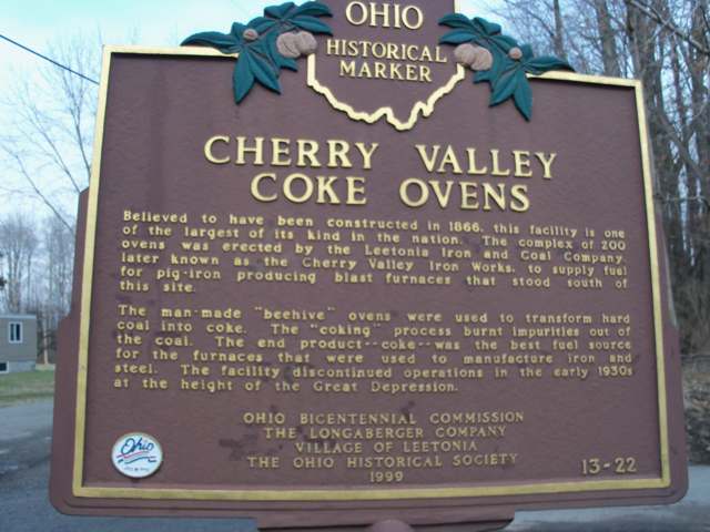
Photo: Roseohioresident (Wikimedia Commons), CC0 · Wikimedia Commons
Local history sources: en.wikipedia.org · commons.wikimedia.org
Historic places
1 place in Leetonia on the National Register of Historic Places. Press a pin or a name for its whole record.
-
Schmick, Charles Nelson, HouseBuilding · Leetonia · listed 1991
- Address
- 110 Walnut St.
- Where
- Leetonia, Columbiana County · ZIP 44431
- What it is
- Building
- Listed on the National Register
- 1991
- NRIS reference number
- 91000250
- Coordinates
- 40.87977, -80.75982
National Register file (NPS) ↗ Search Wikipedia ↗ Street map and directions ↗ On the Cracked Buckeye map
Source: National Park Service, National Register of Historic Places point file. The listing year is shown where NPS's certification date agrees with the listing's reference number. Listing recognizes significance; it does not restrict a private owner.
Water
Mostly private wells The water here
- Leetonia Village97% of residentsEast Cold Run Reservoir & Spring Valley Reservoir (Cold Run Creek)
- Washingtonville Village3% of residentsEast Cold Run Reservoir & Spring Valley Reservoir (Cold Run Creek)
Hospitals, fire stations and more
Inside Leetonia's boundary: 1 fire or EMS station, 2 public schools, 1 library, 1 police station, 2 Toxics Release Inventory facilities and 2 spill cases. Press a pin or a name for its whole record and its source.
Fire and EMS stations (1)
-
Leetonia Fire DepartmentLeetonia
- Address
- 300 East Main Street, Leetonia, OH 44431
- Coordinates
- 40.87945, -80.75496
USGS National Map structures (source) ↗ Street map and directions ↗
Source: USGS National Map structures (most Ohio records last updated 2019 to 2022), checked against the Columbus and Cleveland station lists. The department that answers a call is set by jurisdiction and mutual aid, not by distance.
Public schools (2)
-
Leetonia Elementary K-63.5 of 5 stars · Leetonia
- Address
- 450 Walnut St, Leetonia, OH 44431
- School district
- Leetonia Ex Vill School District
- Kind (NCES)
- Regular School
- Students, 2023-24
- 270
- Teachers (full-time equivalent)
- 18
- Report card, 2025-26
- 3.5 of 5 stars
- Performance index
- 79.6%
- Ohio building IRN
- 028746
- NCES school ID
- 391000702218
NCES school record ↗ Ohio School Report Card ↗ Street map and directions ↗
-
Leetonia Jr./Sr. High School3 of 5 stars · Leetonia
- Address
- 450 Walnut St, Leetonia, OH 44431
- School district
- Leetonia Ex Vill School District
- Kind (NCES)
- Regular School
- Students, 2023-24
- 222
- Teachers (full-time equivalent)
- 16
- Report card, 2025-26
- 3 of 5 stars
- Performance index
- 78%
- Four-year graduation rate
- 93.3%
- Ohio building IRN
- 020107
- NCES school ID
- 391000702217
NCES school record ↗ Ohio School Report Card ↗ Street map and directions ↗
Source: NCES EDGE public school locations 2024-25 and Common Core of Data 2023-24 (type, students, teachers); Ohio School Report Cards 2025-26 (Department of Education and Workforce), matched by name within the district.
Public libraries (1)
-
Leetonia Community Public LibraryCentral library · Leetonia
- Address
- 181 Walnut Street, Leetonia, OH 44431
- What it is
- Central library
- Library system
- Leetonia Community Public Library
- Open
- 2,158 hours a year, 52 weeks
- Building
- 13,800 sq ft
- System's visits, FY2024
- 6,760
- System's loans, FY2024
- 23,793
- People the system serves
- 4,417
- Phone
- (330) 427-6635
IMLS Public Libraries Survey (source) ↗ Street map and directions ↗
Source: IMLS Public Libraries Survey FY2024 (outlets and their systems). Any Ohio resident can get a free card at any Ohio public library.
Police stations (1)
-
Leetonia Police DepartmentLeetonia
- Address
- 300 East Main Street, Leetonia, OH 44431
- Coordinates
- 40.87877, -80.75525
USGS National Map structures (source) ↗ Street map and directions ↗
Source: USGS National Map structures, police stations, corrected and completed by hand (September 2026). The department that answers a call is set by jurisdiction, not by distance.
Facilities reporting toxic releases (2)
-
Cmg LlcToxics Release Inventory · Leetonia
- Address
- 360 Main St, Leetonia, OH 44431
- County
- Columbiana County
- Status
- Reports to the Toxics Release Inventory
- EPA program ID
- TRI_OFFSITE_462
- EPA registry ID
- 110070691035
EPA facility record ↗ EPA Facility Registry Service (source) ↗ Street map and directions ↗
-
Pennex Aluminum Co LlcToxics Release Inventory · Leetonia
- Address
- 1 Commerce Ave, Leetonia, OH 44431
- County
- Columbiana County
- Status
- Reports to the Toxics Release Inventory (active)
- EPA program ID
- 44431GFCLM1CMME
- EPA registry ID
- 110024426708
EPA facility record ↗ EPA Facility Registry Service (source) ↗ Street map and directions ↗
Source: EPA Facility Registry Service, Toxics Release Inventory reporters. Reporting a release is required of large users of listed chemicals; it is not by itself a violation.
Spills reported since 2021 (2)
-
Paint Nos / Lacquer (Not Specified)2025-04-12 · Leetonia
- Reported
- 2025-04-12
- What spilled
- Paint Nos / Lacquer (Not Specified); Acetone ((Ch3)2Co)
- Where
- Leetonia, Columbiana County
- Ohio EPA district office
- NEDO
- Ohio EPA case number
- 2504EPA0000549
Ohio EPA spill reports (source) ↗ Street map and directions ↗
-
Oil Hydraulic Fluid(S)2023-05-24 · Leetonia
- Reported
- 2023-05-24
- What spilled
- Oil Hydraulic Fluid(S)
- Largest amount reported
- 65 gallons
- Where
- Leetonia, Columbiana County
- Ohio EPA district office
- NEDO
- Ohio EPA case number
- 2305EPA0000843
Ohio EPA spill reports (source) ↗ Street map and directions ↗
Source: Ohio EPA emergency response spill reports, 2021 to September 2026, one point per case where Ohio EPA placed it. A report is what the caller or responder recorded; amounts are often blank or estimated.
Its ZIP codes
Each ZIP code that touches Leetonia, with the share of its residents who live here and the same headline figures as the ZIP page.
Local government
Who holds office in Leetonia, how its elections and ballot issues came out, and the state auditor's record.
Elections for office
| Date | Office | Candidates and votes |
|---|---|---|
| 2023-11-07 | Member of Council | John Ferry, Jr. (DEM) 333, 53.62%; Sue A. Strobel (DEM) 288, 46.38% |
| 2023-11-07 | Mayor | Kevin M. Siembida (REP) 460, 100.0% |
| 2021-11-02 | Member of Council | William G. Garlough (DEM) 161, 44.6%; Suzanne Tobuck 174, 48.2%; Write-In: Ashley Johnson 10, 2.77%; Write-In: Richard W. Newton II 6, 1.66% |
Winners in bold. Results from the county board of elections' official canvass unless marked.
The county
Columbiana County: 20 ZIP codes, 33 cities, villages and townships, 106,075 people.
Nearby places
Rain and snow
How much has actually fallen on Leetonia, day by day, from 1892 to now. Daily totals, not averages.
- rain, last 30 days
- 1.41 in
- 2026-09-30 to 2026-10-29
- rain so far in 2026
- 38.5 in
- 3.1 in above normal for the date
- snow so far in 2026
- 32.7 in
- a normal year brings 36.9 in
- a normal year
- 41.5 in
- average of 30 years, 1991-2020
| Month | Rain (in) | Snow (in) | Days counted |
|---|---|---|---|
| October 2026 | 1.41 | — | 29 |
| September 2026 | 5.96 | — | 30 |
| August 2026 | 5.69 | — | 31 |
| July 2026 | 4.82 | — | 31 |
| June 2026 | 2.42 | — | 30 |
| May 2026 | 5.09 | — | 31 |
| April 2026 | 5.46 | — | 30 |
| March 2026 | 4.23 | 3.6 | 31 |
| February 2026 | 0.90 | 6.3 | 28 |
| January 2026 | 2.46 | 22.8 | 31 |
| December 2025 | 2.18 | 11.4 | 31 |
| November 2025 | 1.92 | 0.5 | 30 |
| Wettest year | 1996 — 54.3 in |
|---|---|
| Driest year | 1963 — 25.6 in |
| Snowiest year | 2010 — 73.0 in |
| Wettest day on record | 9 September 2004 — 5.06 in |
| Heaviest snowfall in a day | 20 April 1901 — 18.16 in |
| Deepest snow on the ground | 28 November 1950 — 25.26 in |
Estimated, not measured. No rain gauge has ever stood inside Leetonia, so every figure here is worked out from the gauges around it - the nearest ones weighted most. Treat them as close estimates rather than readings.
49,002 days of records, 1892-05-01 to 2026-10-29. Source: NOAA NCEI GHCN-Daily, 3,240 gauges in and around Ohio. A day is "gauged" when a gauge standing inside the boundary reported it, and the value is the mean of those gauges. Otherwise it is interpolated by inverse distance from every gauge reporting within 50 miles. Nothing is carried forward, back-filled or smoothed. Against NOAA nClimDiv county monthly precipitation over 136,848 complete county-months (checked 2026-10-31): correlation 0.9515, median absolute difference 0.217 in a month. Built 2026-10-31 from the Cracked Buckeye precipitation archive. Snow is the softer number — snowfall is measured by hand with a ruler, no agency publishes a gridded county snowfall series, and blowing snow defeats every observer.
Environmental permits and filings
What Ohio EPA has on file for Leetonia: permits, inspections, violations, cleanups and the state loans behind sewer and water work. Every line links to the agency's own document.
- facilities and sites on file
- 12
- those placed on the map inside Leetonia
| Program | Facilities and sites |
|---|---|
| Wastewater and stormwater discharge | 4 |
| Hazardous waste | 2 |
| Wetland and stream fill | 2 |
| Air pollution | 1 |
| Public drinking water | 1 |
| Sewer and water-line construction | 1 |
| Source-water protection | 1 |
| Date | Facility or site | What |
|---|---|---|
| LEETONIA VILLAGE PWS | Public drinking water compliance letter | |
| LEETONIA VILLAGE PWS | Public drinking water compliance letter | |
| LEETONIA VILLAGE PWS | Public drinking water compliance letter | |
| LEETONIA VILLAGE PWS | Public drinking water compliance letter | |
| LEETONIA VILLAGE PWS | Public drinking water compliance letter | |
| LEETONIA VILLAGE PWS | Public drinking water compliance letter | |
| QUAKER CITY CONCRETE PRODUCTS | Air pollution report | |
| LEETONIA VILLAGE PWS | Public drinking water report | |
| TCO E039418 LINE V66 PROJECT (ORAM VERIFICATION) | Wetland and stream fill permit | |
| TCO E039418 LINE V66 PROJECT | Wetland and stream fill permit | |
| TCO E039418 LINE V66 PROJECT (ORAM VERIFICATION) | Wetland and stream fill permit | |
| LEETONIA VILLAGE PWS | Public drinking water violation resolved | |
| LEETONIA VILLAGE PWS | Public drinking water notice of violation | |
| QUAKER CITY CONCRETE PRODUCTS | Air pollution permit | |
| LEETONIA WWTP | Sewer and water-line construction permit | |
| LEETONIA VILLAGE PWS | Public drinking water inspection | |
| LEETONIA VILLAGE PWS | Public drinking water inspection | |
| LEETONIA VILLAGE PWS | Public drinking water plan | |
| LEETONIA VILLAGE PWS | Public drinking water letter | |
| LEETONIA VILLAGE PWS | Public drinking water compliance letter | |
| LEETONIA VILLAGE PWS | Public drinking water inspection | |
| LEETONIA VILLAGE PWS | Public drinking water compliance letter | |
| LEETONIA VILLAGE PWS | Public drinking water inspection | |
| LEETONIA VILLAGE PWS | Public drinking water compliance letter | |
| LEETONIA VILLAGE PWS | Public drinking water compliance letter |
Source: Ohio EPA eDocument portal (edocpub.epa.ohio.gov), indexed 2026-10-14. Facilities are placed on the map from Ohio EPA's own map layers, EPA's Facility Registry, coordinates written in the filings, or a geocoded street address. A permit filed under a private person's name (most are household septic systems) is counted but never named, placed or linked; licenses for individual workers and open-burning notices are left out entirely.
Quick answers
What county is Leetonia, Ohio in?
Leetonia is a village in Columbiana County, Ohio, with 1,853 residents.
When was Leetonia, Ohio founded?
Leetonia was settled 1864 (three families); laid out 1866-1867; incorporated 1869. Founders on record: William Lee (Leetonia Iron and Coal Company). Source
How did Leetonia, Ohio get its name?
Named for William Lee of Randolph, New York, who discovered the coal, iron ore and limestone deposits beneath the site and founded the Leetonia Iron and Coal Company that built the town. Source
What ZIP code is Leetonia, Ohio?
Leetonia is served by ZIP codes 44431 and 44490; 44431 holds the largest share of its residents.
Where does Leetonia, Ohio get its water?
The main water source for Leetonia (Leetonia Village): Mostly private wells.
Cite this page
Cite this page as:
Cracked Buckeye, "Leetonia, Columbiana County", https://crackedbuckeye.com/place/leetonia/, built 2026-10-31, accessed [date].
How to cite · Report a correction · Built 2026-10-31
