Local events in Weller Township, Richland County
9 events in the next 90 days from 2 public calendars. All local events in Weller Township, Richland County
Checked October 20; the events page is refreshed daily.
How Weller Township, Richland County began
Weller Township was formed in 1846 (one chapter of Graham's 1880 history dates the transfer of Franklin's sections to 1849), after Ashland County was created, from the two western tiers of sections of old Milton Township, including the village of Olivesburg, and two miles taken from the east side of Franklin Township; Baughman's 1908 county history says it was named for John B. Weller, an Ohio congressman who later became governor of California. Settlement began in 1814 along the Black Fork and the Whetstone, around the 150-foot 'Big Hill' in the township's center. Olivesburg, laid out in 1816 by Benjamin Montgomery and named for his daughter Olive, was its village; the county infirmary was built on the Big Hill's western slope in 1846-47, and the Atlantic and Great Western Railroad crossed the township in 1862-63 with a station at Windsor. It remains a farming township in northeastern Richland County.
Settled 1814 (Benjamin Montgomery, Elijah Charles, Jacob Osbun), incorporated 1846 (organized as a township; Graham's Franklin chapter gives July 5, 1849 for the transfer of Franklin's sections), by formed from Milton and Franklin townships.
Where the name comes from
Named in honor of John B. Weller, 'a former Ohio boy' (Baughman, 1908). Weller, born in Hamilton County, Ohio, in 1812, was a Democratic congressman from Ohio from 1839 to 1845, served as a lieutenant colonel in the Mexican War in 1846-47, and was governor of California from 1858 to 1860. Baughman calls him 'then governor of California', which does not fit the 1846 date.
Before the town
Graham's 1880 county history says that while Native people held the land they burned the forest on the Big Hill every year to keep the undergrowth from blocking the view of game. A saline spring about half a mile west of Windsor Station spread into a marsh the settlers called 'The Deer Lick', which Native hunters and later settlers both used to kill deer. Native people 'lingered around' after settlement, visiting cabins for bread, hominy and powder, and troubled the Charles family's children for two or three years before they were confined to the reservation in what is now Wyandot County. In September 1812 Gen. Reasin Beall's army camped briefly at the site of Olivesburg, calling it Camp Whetstone. The sources do not name the nation of the local visitors; the Wyandot reservation reference points to the Wyandot.
Nations recorded here: Wyandot.
- The Deer Lick (other) — Saline spring and marsh about half a mile west of Windsor Station, before and after settlement (archive.org)
- Camp Whetstone (camp) — Near the present site of Olivesburg, on the Whetstone, September 1812 (U.S. militia under Gen. Reasin Beall) (archive.org)
Timeline
- — Gen. Reasin Beall's army cuts a road through the Whetstone country in September and camps for a short time near the site of Olivesburg, calling it Camp Whetstone.
- — Benjamin Montgomery, Elijah Charles and Jacob Osbun settle; Osbun had marked trees on Section 35 while passing through as a soldier in the War of 1812.
- — Benjamin Montgomery lays out Olivesburg, naming it for his oldest daughter, Olive, and is elected justice of the peace; a log schoolhouse is built on Levi Stevenson's land on the west side of the Big Hill, with James Mahon as teacher.
- — Benjamin Montgomery builds the first gristmill in the township, on the Whetstone at Olivesburg.
- — Elijah Charles builds a sawmill on the Black Fork, still running under David Lind in 1880; his son Isaac adds a gristmill in 1835.
- — Thomas Robinson, an Englishman the settlers called 'King Tom', settles on the Big Hill (Graham gives 1821) and pays cash wages to clear his land.
- — A 20-foot-square hewed-log schoolhouse with glass windows is built at Olivesburg; teacher Joseph Ward is paid one-third in corn, one-third in maple sugar and one-third in money.
- — The Presbyterians build a $500 frame church at Olivesburg, the first church of any size in the township (Knapp's 1863 Ashland County history dates the Olivesburg congregation's formation from Hopewell Church to April 21, 1834).
- — The Olivesburgh post office opens on February 6.
- — Thomas Robinson builds a large brick house with stone-arched cellars on the summit of the Big Hill, called the 'castle'; a windstorm damages it about two years later and its foundation later gives way.
- — Weller Township is created, and the county commissioners buy 160 acres from the heirs of Nathaniel Osbun for a county infirmary, built by Col. George Weaver of Ganges for $4,500 and occupied the next year.
- — A hard frost on the night of June 4-5 freezes the township's wheat, corn and gardens.
- — The Atlantic and Great Western Railroad is built across the township in 1862-63, with a station at the crossing of the Windsor and Olivesburg road.
- — The railroad bridge over the Black Fork a mile east of Windsor Station collapses under a freight train; no one is killed.
- — The infirmary building burns in June; a new building costing $30,000 to $40,000 is begun in 1879.
- — The Olivesburg post office closes on September 14, with mail handled from Ashland.
- — The Richland County Infirmary, at 3220 Mansfield-Olivesburg Road, is listed on the National Register of Historic Places as a district on September 24; its architect is given as F. F. Schnitzer.
Stories
King Tom's castle
Thomas Robinson came from England about 1820 and entered land on the Big Hill. He wore knee breeches in the old English style, kept ten to fifteen men employed year round, and paid them in gold to dig out stumps instead of waiting for them to rot, so that settlers short of tax money would go to 'dig out stumps for Robinson'. After clearing his land he went back to England for seven years to marry, and in 1836 built a large brick house with arched stone cellars on the summit, which the neighbors called the castle. A windstorm damaged it about two years later, and the arched foundation spread until the building fell into ruins. Graham's history says Robinson went back to England in 1843 and died there; later visitors to the ruins were told stories of buried wives that Robinson's relatives had to correct.
The silver bullet
About 1831 or 1832 a family living on the farm later occupied by the county infirmary came to believe that a neighbor, Mrs. Holstein, was bewitching their churns and sugar kettles. Graham's 1880 history says a meeting of 'believers' decided to shoot the witch by proxy: they made a dough image of her, set it on a chimney corner, and had a marksman shoot it with a bullet melted from silver sixpences. Word went around that Mrs. Holstein had a matching wound, and she died shortly afterward, which strengthened some in their belief. The next year a 'witch doctor' from north of Mansfield was called to mutter over the sugar kettles. The historian wrote that most of the community scouted the whole affair; Baughman's 1908 history retells it in brief.
Barred out on Christmas morning
Levi Stevenson came from Beaver County, Pennsylvania, in 1815 and settled northwest of the Big Hill. In 1818 he was hired to teach in a small log cabin on the southeast corner of his land. It was the custom then for older boys to 'bar out' the teacher to make him treat, and before daylight on Christmas morning several young men shut Stevenson out of the schoolhouse. He climbed the corner of the building and jumped down the chimney, where a fire of ten-foot hickory logs was burning. The boys surrendered, and the 1880 historian noted that his buckskin breeches saw him through.
Photographs
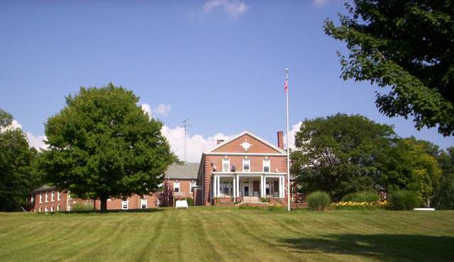
Photo: OHWiki / Wikimedia Commons, public domain · Wikimedia Commons
Local history sources: en.wikipedia.org · en.wikipedia.org · en.wikipedia.org · en.wikipedia.org · archive.org · archive.org · archive.org · archive.org · archive.org · archive.org · archive.org · archive.org · archive.org · archive.org · archive.org · archive.org · archive.org · archive.org · archive.org · archive.org · archive.org · npgallery.nps.gov · commons.wikimedia.org
Water
Mostly private wells The water here
- Mansfield City50% of residentsClear Fork Reservoir (Clear Fork of the Mohican River), plus 9 city wells
- Ashland City23% of residentsJerome Fork Basin sand-and-gravel aquifer (wells)
- Ontario City7% of residentsGroundwater wells (3 wells)
- Shiloh Village5% of residentsGroundwater wells (2 wells)
- Greenwich Village3% of residentsGroundwater wells (6 wells)
- Rural Lorain Co. Water A2% of residentsMostly Lake Erie (bought from Avon Lake); some New London Reservoir and Ashland wells
- Aqua Ohio - Mansfield System #022% of residentsGroundwater wells (3 wells)
- Lakeview Estates MHP2% of residentsGroundwater wells (2 wells)
- Eastview Community Water Association2% of residentsGroundwater wells (3 wells)
- Aqua Ohio - Mansfield System #031% of residentsGroundwater wells (1 wells)
- Madison Water District1% of residentsGroundwater wells (4 wells)
- Aqua Ohio - Mansfield System #080% of residentsGroundwater wells (1 wells)
- Bailey Lakes Village0% of residentsLake Erie
- Hanley Acres Water Association0% of residentsGroundwater wells (2 wells)
- Willow Park Water Association0% of residentsGroundwater wells (2 wells)
- Northern Ohio Rural Water - SE District0% of residentsLake Erie
- Hayesville Village0% of residentsGroundwater wells (2 wells)
- Hillside MHP0% of residentsGroundwater wells (1 wells)
Hospitals, fire stations and more
Inside Weller Township, Richland County's boundary: 3 public schools, 1 poor-rated bridge, 1 library, 1 Superfund site and 2 spill cases. Press a pin or a name for its whole record and its source.
Public schools (3)
-
Crestview Elementary School3.5 of 5 stars · Ashland
- Address
- 1575 State Route 96, Ashland, OH 44805
- School district
- Crestview Local School District
- Kind (NCES)
- Regular School
- Students, 2023-24
- 364
- Teachers (full-time equivalent)
- 16
- Report card, 2025-26
- 3.5 of 5 stars
- Performance index
- 81.3%
- Ohio building IRN
- 033639
- NCES school ID
- 390494203585
NCES school record ↗ Ohio School Report Card ↗ Street map and directions ↗
-
Crestview High School3.5 of 5 stars · Ashland
- Address
- 1575 State Route 96, Ashland, OH 44805
- School district
- Crestview Local School District
- Kind (NCES)
- Regular School
- Students, 2023-24
- 260
- Teachers (full-time equivalent)
- 17
- Report card, 2025-26
- 3.5 of 5 stars
- Performance index
- 80%
- Four-year graduation rate
- 97.5%
- Ohio building IRN
- 007674
- NCES school ID
- 390494203583
NCES school record ↗ Ohio School Report Card ↗ Street map and directions ↗
-
Crestview Middle School3.5 of 5 stars · Ashland
- Address
- 1575 State Route 96, Ashland, OH 44805
- School district
- Crestview Local School District
- Kind (NCES)
- Regular School
- Students, 2023-24
- 268
- Teachers (full-time equivalent)
- 28
- Report card, 2025-26
- 3.5 of 5 stars
- Performance index
- 77.4%
- Ohio building IRN
- 037796
- NCES school ID
- 390494203586
NCES school record ↗ Ohio School Report Card ↗ Street map and directions ↗
Source: NCES EDGE public school locations 2024-25 and Common Core of Data 2023-24 (type, students, teachers); Ohio School Report Cards 2025-26 (Department of Education and Workforce), matched by name within the district.
Bridges rated poor (1)
-
Franklin Church Rd over East Fork Brubaker CreekPoor · built 1982
- Condition
- Poor: a deck, superstructure, substructure or culvert rated 4 or below on the 0 to 9 scale
- What it is
- Bridge
- Built
- 1982
- Length
- 9 ft
- Owner
- County
- Vehicles a day
- 477
- Coordinates
- 40.84926, -82.47951
National Bridge Inventory (source) ↗ Street map and directions ↗
Source: FHWA National Bridge Inventory 2025. "Poor" means one major part rated 4 or below on the 0 to 9 scale; it calls for repair, not closing, unless the state posts or closes the bridge.
Public libraries (1)
-
Crestview BranchBranch · Ashland
- Address
- 1575 St Rt 96 E, Ashland, OH 44805
- What it is
- Branch
- Library system
- Mansfield-Richland County Public Library
- Open
- 2,964 hours a year, 52 weeks
- Building
- 3,600 sq ft
- System's visits, FY2024
- 514,540
- System's loans, FY2024
- 1,567,119
- People the system serves
- 99,110
- Phone
- (419) 895-0010
IMLS Public Libraries Survey (source) ↗ Street map and directions ↗
Source: IMLS Public Libraries Survey FY2024 (outlets and their systems). Any Ohio resident can get a free card at any Ohio public library.
Superfund sites (1)
-
Richland Moulded BricksSuperfund program · Mansfield
- Address
- 775-1000 Richland Shale Road, Mansfield, OH 44905
- County
- Richland County
- Status
- Superfund program site, not on the National Priorities List
- EPA program ID
- OHN000510798
- EPA registry ID
- 110046428111
EPA facility record ↗ EPA Facility Registry Service (source) ↗ Street map and directions ↗
Source: EPA Facility Registry Service, Superfund (SEMS) and National Priorities List sites. Many program sites were assessed and needed no cleanup.
Spills reported since 2021 (2)
-
Fuel Diesel / Diesel Fuel (Vehicle On Or Off Road)2022-05-11 · Weller Twp
- Reported
- 2022-05-11
- What spilled
- Fuel Diesel / Diesel Fuel (Vehicle On Or Off Road)
- Largest amount reported
- 25 gallons
- Where
- Weller Twp, Richland County
- Ohio EPA district office
- NWDO
- Ohio EPA case number
- 2205EPA0000674
Ohio EPA spill reports (source) ↗ Street map and directions ↗
-
Fuel Diesel / Diesel Fuel (Vehicle On Or Off Road)2026-08-13 · Weller Twp
- Reported
- 2026-08-13
- What spilled
- Fuel Diesel / Diesel Fuel (Vehicle On Or Off Road)
- Largest amount reported
- 300 gallons
- Where
- Weller Twp, Richland County
- Ohio EPA district office
- NWDO
- Ohio EPA case number
- 2608EPA0001488
Ohio EPA spill reports (source) ↗ Street map and directions ↗
Source: Ohio EPA emergency response spill reports, 2021 to September 2026, one point per case where Ohio EPA placed it. A report is what the caller or responder recorded; amounts are often blank or estimated.
Its ZIP codes
Each ZIP code that touches Weller Township, Richland County, with the share of its residents who live here and the same headline figures as the ZIP page.
| ZIP | Share | Water | Radon | Home value | Schools | Flood |
|---|---|---|---|---|---|---|
| 44878 Bloominggrove Township and Shiloh | 8% | Mostly private wells | 5.2 pCi/L average radon | Median year built 1952 | Plymouth-Shiloh Local · 4 stars overall | 3.6% of residents in the 1% floodplain |
| 44903 Mansfield | 5% | Mostly private wells | 4.5 pCi/L average radon | Median year built 1957 | Mansfield City · 3 stars overall | 2.1% of residents in the 1% floodplain |
| 44837 Greenwich | 2% | Mostly private wells | 4.1 pCi/L average radon | Median year built 1974 | South Central Local · 3.5 stars overall | 1.0% of residents in the 1% floodplain |
| 44805 Ashland | 1% | Wells (14 listed as active in EPA SDWIS: Wells 1-7 and 10-15; Well 9 was deactivated 2025-11-17) in the Jerome Fork Basin sand-and-gravel aquifer, sited generally north of the treatment plant on Cleveland Road | 5.8 pCi/L average radon | Median year built 1964 | Ashland City · 4 stars overall | 2.6% of residents in the 1% floodplain |
Local government
Who holds office in Weller Township, Richland County, how its elections and ballot issues came out, and the state auditor's record.
Money issues on the ballot since 2015: 1 of 1 passed.
Ballot issues
| Date | Issue | For | Against | Result |
|---|---|---|---|---|
| 2015-11-03 | Issue: Weller Township-Tax Levy-Renw'l-3M 5Yrs-Fire (3.0 mills, renewal) | 441 | 203 | Passed (68.48% for) |
Elections for office
| Date | Office | Candidates and votes |
|---|---|---|
| 2015-11-03 | Trustee (number of seats not on file, so winners are not marked) | Terry Rhoades 287, 45.7%; Duwayne Shoup, II 170, 27.07%; Rick Stimpert 108, 17.2%; Travis Cantleberry 63, 10.03% |
| 2015-11-03 | Fiscal Officer | Sara Martin 347, 55.08%; Patricia A. Shoup 283, 44.92% |
Winners in bold. Results from the county board of elections' official canvass unless marked.
Auditor of State record
- No fiscal caution, watch or emergency on the Auditor of State's lists.
- Agreed Upon Procedures, 2023 to 2024, released 2025-08-19
The county
Richland County: 12 ZIP codes, 27 cities, villages and townships, 124,341 people.
Nearby places
Quick answers
What county is Weller Township, Ohio in?
Weller Township, Richland County is a township in Richland County, Ohio, with 1,884 residents.
When was Weller Township, Ohio founded?
Weller Township, Richland County was settled 1814 (Benjamin Montgomery, Elijah Charles, Jacob Osbun); incorporated 1846 (organized as a township; Graham's Franklin chapter gives July 5, 1849 for the transfer of Franklin's sections). Founders on record: formed from Milton and Franklin townships. Source
How did Weller Township, Ohio get its name?
Named in honor of John B. Source
What ZIP code is Weller Township, Ohio?
Weller Township, Richland County is served by ZIP codes 44878, 44903 and 44837; 44878 holds the largest share of its residents.
Where does Weller Township, Ohio get its water?
The main water source for Weller Township, Richland County (Mansfield City): Mostly private wells.
Cite this page
Cite this page as:
Cracked Buckeye, "Weller Township, Richland County", https://crackedbuckeye.com/place/weller-township-richland-county/, built 2026-10-31, accessed [date].
How to cite · Report a correction · Built 2026-10-31
