Local events in Madison Township, Richland County
22 events in the next 90 days from 3 public calendars. All local events in Madison Township, Richland County
Checked October 20; the events page is refreshed daily.
How Madison Township, Richland County began
Madison Township originally comprised the whole of Richland County when it was organized by Knox County commissioners on June 10, 1809, named for President James Madison. Jacob Newman, who arrived in early 1807, is recorded as its first permanent settler, and the township's early economy grew up around Newman's sawmill (1809) and gristmill (1810) on section 36, later known as Beam's Mills. Small crossroads communities such as Woodville and Yankeetown grew up within the township, and today it surrounds much of eastern Mansfield as a mostly residential and rural township.
Settled 1807, incorporated 1809, by organized by Knox County commissioners; first settler Jacob Newman.
Where the name comes from
Named in honor of President James Madison, the fourth president of the United States, at its organization in 1809.
Before the town
Madison Township has one specific, if grim, Native American story tied to the aftermath of the 1812 removal and burning of the Delaware (Lenape) village of Greentown (in what is now Ashland County, about twelve miles from Mansfield). An Indian named Toby escaped from the group being removed and was killed near a stream in the township that was afterward called Toby Run. Following a later altercation, two young Delaware men, Seneca John and Quilipetoxe, were killed; their bodies were buried in a spot local tradition named 'Spooks' Hollow.' These episodes are recorded in the 1903 Baughman township history and are among the only site-specific Native references found for Madison Township; no mound, earthwork, or named village within the township itself is recorded in the sources consulted. See the county-level file for the broader treaty and settlement picture.
Nations recorded here: Lenape (Delaware).
- Toby Run (other) — Madison Township, Richland County, 1812 (richland.ohgenweb.org)
- Spooks' Hollow (burial) — Madison Township, Richland County, 1812 or shortly after (richland.ohgenweb.org)
Timeline
- — Gen. James Hedges, a government surveyor, worked in the future township with Maxfield Ludlow and Jonathan Cox, a year before the first settlement.
- — Jacob Newman, the township's first permanent settler, builds a log cabin on section 36 with his household including three nephews and a niece.
- — Jacob Newman, induced by his kinsman James Hedges, built the first cabin in the township and in the county on Rocky Fork, near a fine spring, where the partners at first meant to lay out a town they hoped would become the county seat.
- — Joseph Larwill, James Hedges and Jacob Newman abandoned the Rocky Fork town and laid out Mansfield on Hedges's land; Doctor Bushnell said Hedges paid the Rocky Fork settlers $1,500 in silver to move.
- — Knox County commissioners declare all of what is now Richland County a separate township named Madison, on June 10.
- — The Newman family builds the area's first sawmill.
- — A gristmill is added, and in 1811 Michael Beam purchases and improves both mills, which become known locally as Beam's Mills.
- — Toby, escaping removal from the Delaware village of Greentown, is killed in the township near the stream later named Toby Run.
- — Greene Township was created from the eastern part of Madison, which until then covered the whole of what became Richland County.
- — A third division of Madison Township left it the northwestern township of the county, eighteen miles square.
- — Madison was reduced to its present dimensions, six miles square in the center of the county.
- — A stone farmhouse in the township area, later expanded and known as the Samuel Lewis House, is purchased and enlarged by Samuel Lewis; it is listed on the National Register of Historic Places in 1982.
- — The census counted 11,106 residents in the 15.7-square-mile township, which includes much of the city of Mansfield.
Stories
Beam's Mills draws settlers for miles
The Newman family built Madison Township's first sawmill in 1809 and a gristmill the following year, on section 36 of the township. In 1811 Michael Beam bought and improved the operation, and it became known across the surrounding country as Beam's Mills. Farmers travelled considerable distances to have their grain ground there, since a working gristmill was scarce on the Ohio frontier in that decade. The mill site anchored early settlement in the township at a time when the whole of what would become Richland County was still organized as a single township bearing Madison's name.
The county seat that was moved off Rocky Fork
When Jacob Newman built the first cabin in Madison Township and the county, in 1807, it stood on Rocky Fork near a beautiful spring, about three miles southeast of where Mansfield is today. His kinsman, the surveyor James Hedges, and Newman knew that a new county would soon be created and meant to profit by laying out a town beside that spring. They surveyed it but never platted or recorded it, and no settlers were brought in. The 1880 history guessed at the reason they gave it up: the big spring on Fourth Street, a more central location, or, as Doctor Bushnell said, the fact that Hedges had entered the section where the city now stands and paid the Rocky Fork settlers $1,500 in silver to move there. On June 11, 1808, Larwill, Hedges and Newman laid out Mansfield, naming it for Col. Jared Mansfield, the Surveyor General under whose orders Hedges had worked.
Photographs
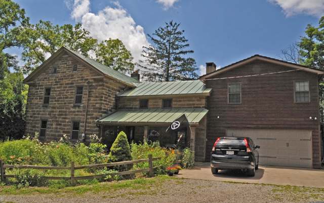
Photo: Jerrye and Roy Klotz, MD, CC BY-SA 4.0 · Wikimedia Commons
Local history sources: richland.ohgenweb.org · en.wikipedia.org · en.wikipedia.org · ashlandcountypictures.com · archive.org · en.wikipedia.org
Historic places
1 place in Madison Township, Richland County on the National Register of Historic Places. Press a pin or a name for its whole record.
-
Lewis, Samuel, HouseBuilding · Mansfield · listed 1982
- Address
- 291 N. Stewart Rd.
- Where
- Mansfield, Richland County · ZIP 44905
- What it is
- Building
- Listed on the National Register
- 1982
- NRIS reference number
- 82003636
- Coordinates
- 40.76625, -82.47616
National Register file (NPS) ↗ Search Wikipedia ↗ Street map and directions ↗ On the Cracked Buckeye map
Source: National Park Service, National Register of Historic Places point file. The listing year is shown where NPS's certification date agrees with the listing's reference number. Listing recognizes significance; it does not restrict a private owner.
Water
Mostly private wells The water here
- Mansfield City41% of residentsClear Fork Reservoir (Clear Fork of the Mohican River), plus 9 city wells
- Ontario City11% of residentsGroundwater wells (3 wells)
- Eastview Community Water Association10% of residentsGroundwater wells (3 wells)
- Madison Water District9% of residentsGroundwater wells (4 wells)
- Aqua Ohio - Mansfield System #076% of residentsGroundwater wells (4 wells)
- Heatherwood Community Water Assoc4% of residentsGroundwater wells (1 wells)
- Crestwood Hills C and R Association4% of residentsGroundwater wells (2 wells)
- Aqua Ohio - Mansfield System #064% of residentsGroundwater wells (2 wells)
- Expressview Comm Water Association2% of residentsGroundwater wells (2 wells)
- Aqua Ohio - Mansfield System #012% of residentsGroundwater wells (2 wells)
- Shelly Acres Water Association2% of residentsGroundwater wells (3 wells)
- Aqua Ohio - Mansfield System #041% of residentsGroundwater wells (1 wells)
- Peyton Community Well1% of residentsGroundwater wells (1 wells)
- Hillside MHP1% of residentsGroundwater wells (1 wells)
- Waterfall Estates MHP1% of residentsGroundwater wells (1 wells)
- Aqua Ohio - Mansfield System #020% of residentsGroundwater wells (3 wells)
- Hillsdale Community Water Association Pw0% of residentsGroundwater wells (1 wells)
- Colonial Hills MHP0% of residentsGroundwater wells (1 wells)
- Lakeview Estates MHP0% of residentsGroundwater wells (2 wells)
- Heatherwood Terrace Townhouses0% of residentsGroundwater wells (2 wells)
- Aqua Ohio - Mansfield System #030% of residentsGroundwater wells (1 wells)
- Aqua Ohio - Mansfield System #080% of residentsGroundwater wells (1 wells)
- Briarwood Estates MHP0% of residentsGroundwater wells (2 wells)
- Edgewood Estates0% of residentsGroundwater wells (1 wells)
- Hanley Acres Water Association0% of residentsGroundwater wells (2 wells)
- Willow Park Water Association0% of residentsGroundwater wells (2 wells)
- Southern Estates Water Assoc0% of residentsGroundwater wells (2 wells)
Hospitals, fire stations and more
Inside Madison Township, Richland County's boundary: 2 fire and EMS stations, 1 college, 5 public schools, 2 private schools, 2 poor-rated bridges, 1 library, 2 museums, 2 Superfund sites, 3 Toxics Release Inventory facilities and 9 spill cases. Press a pin or a name for its whole record and its source.
Fire and EMS stations (2)
-
Madison Township Fire Department Central StationMansfield
- Address
- 843 Expressview Drive, Mansfield, OH 44905
- Coordinates
- 40.78122, -82.47296
USGS National Map structures (source) ↗ Street map and directions ↗
-
Madison Township Fire Department Station 72Mansfield
- Address
- 801 Belmont Avenue, Mansfield, OH 44906
- Coordinates
- 40.78127, -82.54852
USGS National Map structures (source) ↗ Street map and directions ↗
Source: USGS National Map structures (most Ohio records last updated 2019 to 2022), checked against the Columbus and Cleveland station lists. The department that answers a call is set by jurisdiction and mutual aid, not by distance.
Colleges (1)
-
Madison Adult Career CenterPublic two-year college · Mansfield
- What it is
- Public two-year college
- City
- Mansfield
- Students, 2023-24 (12-month count)
- 137
- Graduation rate
- 85% within three years (a class of 65)
- IPEDS unit ID
- 375407
College Navigator (NCES) ↗ IPEDS data (source) ↗ Street map and directions ↗
Source: NCES IPEDS 2024 directory, 2023-24 enrollment and tuition, graduation rates for the 2017 (four-year) and 2020 (two-year) entering classes.
Public schools (5)
-
Eastview Elementary School4 of 5 stars · Mansfield
- Address
- 1262 Eastview Dr, Mansfield, OH 44905
- School district
- Madison Local School District
- Kind (NCES)
- Regular School
- Students, 2023-24
- 236
- Teachers (full-time equivalent)
- 18
- Report card, 2025-26
- 4 of 5 stars
- Performance index
- 90.3%
- Ohio building IRN
- 009704
- NCES school ID
- 390494503594
NCES school record ↗ Ohio School Report Card ↗ Street map and directions ↗
-
Madison Early Childhood Learning CenterMansfield
- Address
- 1035 Grace St, Mansfield, OH 44905
- Kind (NCES)
- Regular School
- Students, 2023-24
- 46
- Teachers (full-time equivalent)
- 5
- NCES school ID
- 390494505140
-
Madison High School3.5 of 5 stars · Mansfield
- Address
- 600 Esley Ln, Mansfield, OH 44905
- School district
- Madison Local School District
- Kind (NCES)
- Regular School
- Students, 2023-24
- 882
- Teachers (full-time equivalent)
- 64.8
- Report card, 2025-26
- 3.5 of 5 stars
- Performance index
- 71.9%
- Four-year graduation rate
- 98.2%
- Ohio building IRN
- 022178
- NCES school ID
- 390494503598
NCES school record ↗ Ohio School Report Card ↗ Street map and directions ↗
-
Madison Middle School4 of 5 stars · Mansfield
- Address
- 1419 Grace St, Mansfield, OH 44905
- School district
- Madison Local School District
- Kind (NCES)
- Regular School
- Students, 2023-24
- 758
- Teachers (full-time equivalent)
- 63
- Report card, 2025-26
- 4 of 5 stars
- Performance index
- 75.5%
- Ohio building IRN
- 022103
- NCES school ID
- 390494503597
NCES school record ↗ Ohio School Report Card ↗ Street map and directions ↗
-
Madison South Elementary School4 of 5 stars · Mansfield
- Address
- 700 S Illinois Ave, Mansfield, OH 44907
- School district
- Madison Local School District
- Kind (NCES)
- Regular School
- Students, 2023-24
- 491
- Teachers (full-time equivalent)
- 33
- Report card, 2025-26
- 4 of 5 stars
- Performance index
- 65%
- Ohio building IRN
- 022152
- NCES school ID
- 390494503599
NCES school record ↗ Ohio School Report Card ↗ Street map and directions ↗
Source: NCES EDGE public school locations 2024-25 and Common Core of Data 2023-24 (type, students, teachers); Ohio School Report Cards 2025-26 (Department of Education and Workforce), matched by name within the district.
Private schools (2)
-
Mansfield Sda SchoolPrivate, religious, independent · Mansfield
- Address
- 1040 W Cook Rd, Mansfield, OH 44906
- Kind
- religious, independent
- Students, 2023-24
- 13
- Teachers (full-time equivalent)
- 2
- Students per teacher
- 6.5
- Phone
- (419) 756-9947
- NCES private school ID
- A2102987
-
Temple Christian SchoolPrivate, conservative Christian · Mansfield
- Address
- 752 Stewart Rd N, Mansfield, OH 44905
- Kind
- conservative Christian
- Students, 2023-24
- 140
- Teachers (full-time equivalent)
- 15.1
- Students per teacher
- 9.27152
- Phone
- (419) 589-9707
- NCES private school ID
- 01064325
Source: NCES Private School Survey 2023-24.
Bridges rated poor (2)
-
Poth Road over Unnamed DitchPoor · built 1976
- Condition
- Poor: a deck, superstructure, substructure or culvert rated 4 or below on the 0 to 9 scale
- What it is
- Bridge
- Built
- 1976
- Length
- 14 ft
- Owner
- County
- Vehicles a day
- 291
- Coordinates
- 40.79544, -82.55351
National Bridge Inventory (source) ↗ Street map and directions ↗
-
Wilging Rd over StreamPoor · built 1936
- Condition
- Poor: a deck, superstructure, substructure or culvert rated 4 or below on the 0 to 9 scale
- What it is
- Bridge
- Built
- 1936
- Length
- 7 ft
- Owner
- County
- Vehicles a day
- 10
- Coordinates
- 40.79895, -82.53730
National Bridge Inventory (source) ↗ Street map and directions ↗
Source: FHWA National Bridge Inventory 2025. "Poor" means one major part rated 4 or below on the 0 to 9 scale; it calls for repair, not closing, unless the state posts or closes the bridge.
Public libraries (1)
-
Madison BranchBranch · Mansfield
- Address
- 1395 Grace St., Mansfield, OH 44905
- What it is
- Branch
- Library system
- Mansfield-Richland County Public Library
- Open
- 2,964 hours a year, 52 weeks
- Building
- 3,290 sq ft
- System's visits, FY2024
- 514,540
- System's loans, FY2024
- 1,567,119
- People the system serves
- 99,110
- Phone
- (419) 589-7050
IMLS Public Libraries Survey (source) ↗ Street map and directions ↗
Source: IMLS Public Libraries Survey FY2024 (outlets and their systems). Any Ohio resident can get a free card at any Ohio public library.
Museums, historical societies, gardens and zoos (2)
-
Living Bible MuseumMuseum · Mansfield
- What it is
- Museum
- City
- Mansfield
- Coordinates
- 40.78708, -82.49569
Search Wikipedia ↗ IMLS Museum Data Files (source) ↗ Street map and directions ↗
The museum list is IMLS's 2018 file; a museum may have closed or moved since.
-
Ohio State ReformatoryHistory museum · Mansfield
- What it is
- History museum
- City
- Mansfield
- Coordinates
- 40.78224, -82.50320
Search Wikipedia ↗ IMLS Museum Data Files (source) ↗ Street map and directions ↗
The museum list is IMLS's 2018 file; a museum may have closed or moved since.
Source: IMLS Museum Data Files, 2018.
Superfund sites (2)
-
Lincoln Fields Coop Water Assn Duke WellSuperfund program · Mansfield
- Address
- Duke Avenue, Mansfield, OH 44905
- County
- Richland County
- Status
- Superfund program site, not on the National Priorities List
- EPA program ID
- OHD000020487
- EPA registry ID
- 110009304305
EPA facility record ↗ EPA Facility Registry Service (source) ↗ Street map and directions ↗
-
Mansfield Voc PlumeSuperfund program · Mansfield
- Address
- Intersection of Bahl Ave. and Erhart Dr., Mansfield, OH 44905
- County
- Richland County
- Status
- Superfund program site, not on the National Priorities List
- EPA program ID
- OHN000510897
- EPA registry ID
- 110055128767
EPA facility record ↗ EPA Facility Registry Service (source) ↗ Street map and directions ↗
Source: EPA Facility Registry Service, Superfund (SEMS) and National Priorities List sites. Many program sites were assessed and needed no cleanup.
Facilities reporting toxic releases (3)
-
Grasan, Inc.Toxics Release Inventory · Mansfield
- Address
- 440 S. Illinois Ave., Mansfield, OH 44907
- County
- Richland County
- Status
- Reports to the Toxics Release Inventory (active)
- EPA program ID
- 44907GRSNQ440SI
- EPA registry ID
- 110000392021
EPA facility record ↗ EPA Facility Registry Service (source) ↗ Street map and directions ↗
-
Harsco Metals - MansfieldToxics Release Inventory · Mansfield
- Address
- 1490 Old Bowman St., C/O Armco, Mansfield, OH 44903
- County
- Richland County
- Status
- Reports to the Toxics Release Inventory (active)
- EPA program ID
- 44903HRSCC1490O
- EPA registry ID
- 110000391941
EPA facility record ↗ EPA Facility Registry Service (source) ↗ Street map and directions ↗
-
Stein,LlcToxics Release Inventory · Mansfield
- Address
- 1490 Old Bowman St, Mansfield, OH 44903
- County
- Richland County County
- Status
- Reports to the Toxics Release Inventory (***unchanged***)
- EPA program ID
- 4490WSTNLL149LD
- EPA registry ID
- 110071434367
EPA facility record ↗ EPA Facility Registry Service (source) ↗ Street map and directions ↗
Source: EPA Facility Registry Service, Toxics Release Inventory reporters. Reporting a release is required of large users of listed chemicals; it is not by itself a violation.
Spills reported since 2021 (9)
-
Fuel Diesel / Diesel Fuel (Vehicle On Or Off Road)2025-12-04 · Madison Twp
- Reported
- 2025-12-04
- What spilled
- Fuel Diesel / Diesel Fuel (Vehicle On Or Off Road)
- Largest amount reported
- 50 gallons
- Where
- Madison Twp, Richland County
- Ohio EPA district office
- NWDO
- Ohio EPA case number
- 2512EPA0001962
Ohio EPA spill reports (source) ↗ Street map and directions ↗
-
Fuel Diesel / Diesel Fuel (Vehicle On Or Off Road)2025-07-30 · Madison Twp
- Reported
- 2025-07-30
- What spilled
- Fuel Diesel / Diesel Fuel (Vehicle On Or Off Road)
- Largest amount reported
- 5 gallons
- Where
- Madison Twp, Richland County
- Ohio EPA district office
- NWDO
- Ohio EPA case number
- 2507EPA0001283
Ohio EPA spill reports (source) ↗ Street map and directions ↗
-
Fuel Diesel / Diesel Fuel (Vehicle On Or Off Road)2025-05-28 · Madison Twp
- Reported
- 2025-05-28
- What spilled
- Fuel Diesel / Diesel Fuel (Vehicle On Or Off Road)
- Largest amount reported
- 100 gallons
- Where
- Madison Twp, Richland County
- Ohio EPA district office
- NWDO
- Ohio EPA case number
- 2505EPA0000850
Ohio EPA spill reports (source) ↗ Street map and directions ↗
-
Fuel Diesel / Diesel Fuel (Vehicle On Or Off Road)2025-03-11 · Madison Twp
- Reported
- 2025-03-11
- What spilled
- Fuel Diesel / Diesel Fuel (Vehicle On Or Off Road)
- Largest amount reported
- 75 gallons
- Where
- Madison Twp, Richland County
- Ohio EPA district office
- NWDO
- Ohio EPA case number
- 2503EPA0000332
Ohio EPA spill reports (source) ↗ Street map and directions ↗
-
Oil Transformer Non Pcb2024-08-03 · Madison Twp
- Reported
- 2024-08-03
- What spilled
- Oil Transformer Non Pcb
- Largest amount reported
- 1 gallons
- Where
- Madison Twp, Richland County
- Ohio EPA district office
- NWDO
- Ohio EPA case number
- 2408EPA0001336
Ohio EPA spill reports (source) ↗ Street map and directions ↗
-
Oil Transformer Non Pcb2023-03-25 · Madison Twp
- Reported
- 2023-03-25
- What spilled
- Oil Transformer Non Pcb
- Largest amount reported
- 20 gallons
- Where
- Madison Twp, Richland County
- Ohio EPA district office
- NWDO
- Ohio EPA case number
- 2303EPA0000442
Ohio EPA spill reports (source) ↗ Street map and directions ↗
-
Oil Transformer Non Pcb2022-07-20 · Madison Twp
- Reported
- 2022-07-20
- What spilled
- Oil Transformer Non Pcb
- Largest amount reported
- 24 gallons
- Where
- Madison Twp, Richland County
- Ohio EPA district office
- NWDO
- Ohio EPA case number
- 2207EPA0001104
Ohio EPA spill reports (source) ↗ Street map and directions ↗
-
Fuel Diesel / Diesel Fuel (Vehicle On Or Off Road)2021-10-27 · Madison Twp
- Reported
- 2021-10-27
- What spilled
- Fuel Diesel / Diesel Fuel (Vehicle On Or Off Road)
- Largest amount reported
- 100 gallons
- Where
- Madison Twp, Richland County
- Ohio EPA district office
- NWDO
- Ohio EPA case number
- 2110EPA0001667
Ohio EPA spill reports (source) ↗ Street map and directions ↗
-
Fuel Gasoline ( 25% Ethanol Not E85)2026-04-14 · Madison Twp
- Reported
- 2026-04-14
- What spilled
- Fuel Gasoline ( 25% Ethanol Not E85)
- Largest amount reported
- 1 gallons
- Where
- Madison Twp, Richland County
- Ohio EPA district office
- NWDO
- Ohio EPA case number
- 2604EPA0000632
Ohio EPA spill reports (source) ↗ Street map and directions ↗
Source: Ohio EPA emergency response spill reports, 2021 to September 2026, one point per case where Ohio EPA placed it. A report is what the caller or responder recorded; amounts are often blank or estimated.
Its ZIP codes
Each ZIP code that touches Madison Township, Richland County, with the share of its residents who live here and the same headline figures as the ZIP page.
Local government
Who holds office in Madison Township, Richland County, how its elections and ballot issues came out, and the state auditor's record.
Money issues on the ballot since 2015: 1 of 1 passed.
Ballot issues
| Date | Issue | For | Against | Result |
|---|---|---|---|---|
| 2015-11-03 | Issue: Madison Twp-Tax Levy-Renw'l-4M 5Yrs-Fire (4.0 mills, renewal) | 1,591 | 1,008 | Passed (61.22% for) |
Elections for office
| Date | Office | Candidates and votes |
|---|---|---|
| 2015-11-03 | Trustee | Thomas Craft 1,883, 100.0% |
| 2015-11-03 | Fiscal Officer | Sharon Willcox 1,444, 68.24%; Valarie Bishoff 672, 31.76% |
Winners in bold. Results from the county board of elections' official canvass unless marked.
Auditor of State record
- Fiscal caution: declared 2012-05-17, still in effect. source
- Performance Audit, 2024, released 2024-07-16
- Financial Audit, 2022 to 2023, released 2024-07-16
The county
Richland County: 12 ZIP codes, 27 cities, villages and townships, 124,341 people.
Nearby places
Quick answers
What county is Madison Township, Ohio in?
Madison Township, Richland County is a township in Richland County, Ohio, with 11,106 residents.
When was Madison Township, Ohio founded?
Madison Township, Richland County was settled 1807; incorporated 1809. Founders on record: organized by Knox County commissioners; first settler Jacob Newman. Source
How did Madison Township, Ohio get its name?
Named in honor of President James Madison, the fourth president of the United States, at its organization in 1809. Source
What ZIP code is Madison Township, Ohio?
Madison Township, Richland County is served by ZIP codes 44905, 44906 and 44903; 44905 holds the largest share of its residents.
Where does Madison Township, Ohio get its water?
The main water source for Madison Township, Richland County (Mansfield City): Mostly private wells.
Cite this page
Cite this page as:
Cracked Buckeye, "Madison Township, Richland County", https://crackedbuckeye.com/place/madison-township-richland-county/, built 2026-10-31, accessed [date].
How to cite · Report a correction · Built 2026-10-31
