Local events in Ashland
108 events in the next 90 days from 7 public calendars. All local events in Ashland
Checked October 20; the events page is refreshed daily.
Lakes near Ashland
The history under the water: the valley before, the dam, the stories. All Ohio lakes
Deep dives about Ashland
Long reads built from maps, newspapers and public records. All deep dives
History from Ashland
People and inventions tied to this place, each with its sources. All people · All inventions
Videos about Ashland
Short videos we made from the old maps and records. All videos
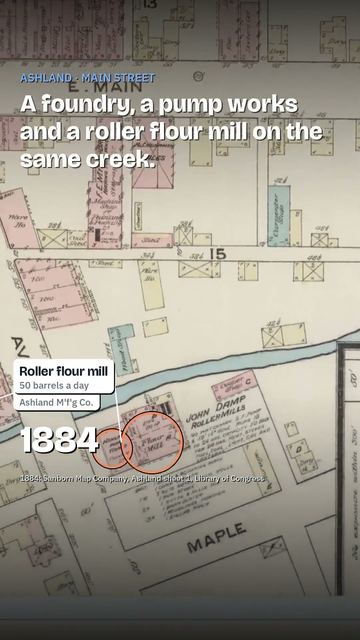
How Ashland began
Ashland was laid out in 1815 by William Montgomery as Uniontown, on land where Daniel Carter had built the area's first cabin in 1811; the name changed to Ashland in 1822, after an earlier Ohio Uniontown claimed the name first, honoring Henry Clay's Kentucky estate at the request of Clay's local political supporters. It became the seat of newly formed Ashland County in 1846. A church-college founded by the German Baptist Brethren in 1878 grew into Ashland University, and a wave of factories -- F.E. Myers & Bro. pumps, Dr. Hess & Clark veterinary remedies, and above all Harry Gill's cigar-shaped balloon patent that spawned Eagle Rubber and National Latex -- made Ashland a manufacturing town known by the mid-20th century as 'the balloon capital of the world.' Today it is a county-seat college town of roughly 20,000 that still runs an annual BalloonFest.
Settled 1811, platted 1815, by William Montgomery (platted as Uniontown); Daniel Carter built the first cabin in 1811.
Where the name comes from
Platted as Uniontown in 1815, the town was renamed Ashland in 1822 because Ohio already had another Uniontown; the new name honored Henry Clay's Kentucky estate 'Ashland' near Lexington, chosen by Clay's local political supporters.
Before the town
No village, mound, or documented encounter site specific to the platted town of Ashland itself turned up in the sources we checked -- the town was founded in 1815 after the Native removals of the War of 1812 period, on ground that was already being settled by Anglo-American families. The county's most documented Native site, however, sits only a few miles away: Greentown, a Lenape (Delaware) village near present Perrysville in Green Township (not within Ashland's city limits), was home to some 150-200 families by 1812. After William Hull's surrender at Detroit in August 1812, American militia removed the Greentown residents toward the Piqua reservation for fear they would side with the British; stragglers among the escorting soldiers then burned the village without authorization. Days later, on September 15, 1812, the burning and the removal helped trigger the attack on the Copus cabin nearby; the Zimmer family had been killed in the same area five days earlier. Ashland County as a whole lies within the area ceded by the Treaty of Greenville (1795) line's outer reaches and later cessions; the county-level history file carries the fuller treaty and mound-builder context, including the Sprott's Hill Mounds archaeological site elsewhere in the county.
Nations recorded here: Lenape (Delaware).
- Greentown (village) — near Perrysville, Green Township, Ashland County (not within Ashland city limits), 1782-1812 (ashlandcountypictures.com)
Timeline
- — Daniel Carter, from Butler County, Pennsylvania, builds the first cabin on the site that becomes Ashland.
- — Nearby Greentown, a Lenape village nea Perrysville, is emptied by forced removal and burned by straggling militia after Hull's surrender at Detroit; the burning helps trigger the attack on the Copus cabin days later in the same area.
- — William Montgomery lays out the town as Uniontown.
- — The town is renamed Ashland, after Henry Clay's Kentucky estate, because another Ohio town already held the name Uniontown.
- — The Studebaker family, including future wagon-and-automobile-company founders Henry and Clement Studebaker, operates a blacksmith and carriage shop near Ashland before the brothers leave for South Bend, Indiana in 1850 to found what becomes the Studebaker Brothers Manufacturing Company.
- — Ashland County is organized from parts of four neighboring counties and Ashland becomes the county seat.
- — The county's first permanent courthouse, of red brick with white trim, Corinthian columns and a spired tower, is built in Ashland after county business had used a church building.
- — Ashland native Lorin Andrews, born 1819, is credited as the first Ohio citizen to volunteer as a Union soldier.
- — Ashland citizens pledge $10,000 to bring a college proposed by the German Baptist Brethren Church to town; the college is chartered February 20, 1878.
- — Ashland College opens for classes on September 17 with about 60 students and eight faculty, in Founders Hall and Allen Hall, built of bricks made on site.
- — The Myers Block-Home Company Building is constructed at 1 E. Main Street in downtown Ashland (later listed on the National Register).
- — Ashland native Harry Ross Gill invents a method for making cigar-shaped rubber balloons and founds the Eagle Rubber Company, launching what becomes the city's balloon industry.
- — F.E. Myers & Bro., a pump and hay-tool manufacturer, employs about 800 workers and is the largest of some 47 factories operating in Ashland.
- — Voters approve a bond issue and the county builds its current Classical Revival courthouse, designed by architect Vernon Redding, for more than $325,000.
- — Harry Gill founds National Latex, adding a second major balloon manufacturer to the city.
- — Ashland College changes its name to Ashland University to reflect its expanded graduate and undergraduate programs.
Stories
The Studebakers' start near Ashland
Before there was a Studebaker automobile, there was a Studebaker blacksmith shop near Ashland. John Studebaker moved his family from Gettysburg, Pennsylvania to what was then Wayne County (later Ashland County) by 1835, and his sons Henry and Clement worked the family's blacksmith and carriage trade at the home shop through the 1840s. Around 1850 Henry and Clement left for South Bend, Indiana, where Clement taught school and Henry hired on as a blacksmith for fifty cents a day; in 1852 the brothers opened their own blacksmith and wagon shop there. That small shop grew into the Studebaker Brothers Manufacturing Company, which became one of the country's largest wagon builders and later a major automaker -- a national industrial name whose roots trace back to a farm shop outside Ashland.
How Ashland became the balloon capital of the world
In 1912 Ashland native Harry Ross Gill worked out how to make a rubber balloon in a cigar shape instead of the standard round one, a manufacturing breakthrough that let one company turn out shaped novelty balloons at a scale no one else could match. Gill started Eagle Rubber Company in 1913, reportedly out of a small garage; in 1929 he founded a second firm, National Latex. The industry Gill built made Ashland known as 'the balloon capital of the world.' The city still marks that legacy every year with its BalloonFest.
A college built on a town's pledge
In the spring of 1877, members of the German Baptist Brethren Church proposed founding a college, and told the town of Ashland that if its citizens would raise $10,000, the college would locate there. The town met the pledge, and Ashland College was chartered on February 20, 1878. Classes began on September 17, 1879, with about 60 students and eight faculty meeting in Founders Hall and Allen Hall -- buildings raised from bricks made on the 28-acre hilltop site the trustees had purchased the year before. The school grew slowly through the 1800s and early 1900s, reaching about 200 students by the early 1900s and roughly 2,500 by 1970; in 1989 it took the name Ashland University to reflect its broadened graduate and undergraduate programs. It now enrolls more than 7,000 students, still on the hill the town's $10,000 bought in 1878.
Photographs
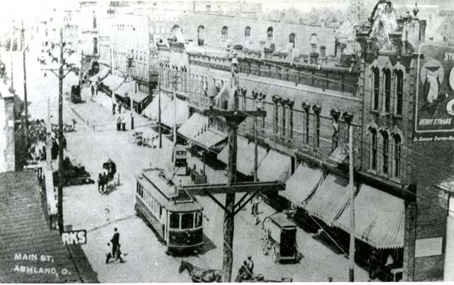
Photo: Columbus Metropolitan Library, via Digital Public Library of America, no known copyright restrictions · Wikimedia Commons
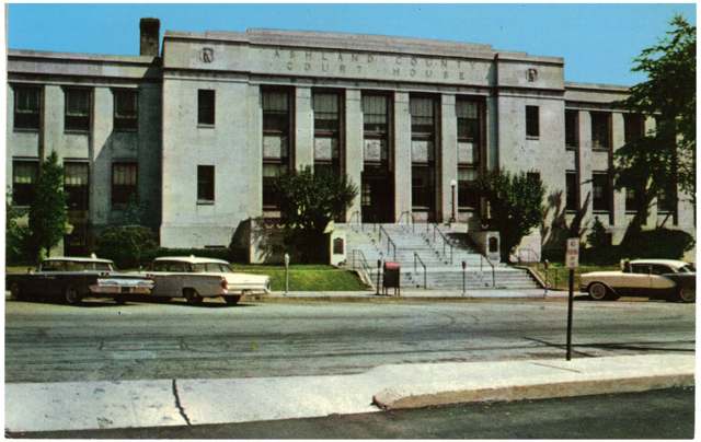
Photo: Columbus Metropolitan Library, via Digital Public Library of America, no known copyright restrictions · Wikimedia Commons
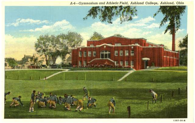
Photo: Columbus Metropolitan Library, via Digital Public Library of America and Ohio Digital Network, no known copyright restrictions · Wikimedia Commons
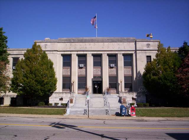
Photo: Wikimedia Commons user OHWiki, public domain · Wikimedia Commons
Local history sources: en.wikipedia.org · en.wikipedia.org · en.wikipedia.org · ashland.edu · en.wikipedia.org · ashlandcountypictures.com · en.wikipedia.org · familysearch.org · ashlandsource.com · commons.wikimedia.org · commons.wikimedia.org · commons.wikimedia.org · commons.wikimedia.org · commons.wikimedia.org
Historic places
2 places in Ashland on the National Register of Historic Places. Press a pin or a name for its whole record.
-
Ashland County CourthouseBuilding · Ashland · listed 1979
- Address
- W. 2nd St.
- Where
- Ashland, Ashland County · ZIP 44805
- What it is
- Building
- Listed on the National Register
- 1979
- NRIS reference number
- 79003786
- Coordinates
- 40.86943, -82.31731
National Register file (NPS) ↗ Search Wikipedia ↗ Street map and directions ↗ On the Cracked Buckeye map
-
Myers Block--Home Company BuildingBuilding · Ashland · listed 1997
- Address
- 1 E. main St.
- Where
- Ashland, Ashland County · ZIP 44805
- What it is
- Building
- Listed on the National Register
- 1997
- NRIS reference number
- 96001620
- Coordinates
- 40.86694, -82.31465
National Register file (NPS) ↗ Search Wikipedia ↗ Street map and directions ↗ On the Cracked Buckeye map
Source: National Park Service, National Register of Historic Places point file. The listing year is shown where NPS's certification date agrees with the listing's reference number. Listing recognizes significance; it does not restrict a private owner.
Water
Wells (14 listed as active in EPA SDWIS: Wells 1-7 and 10-15; Well 9 was deactivated 2025-11-17) in the Jerome Fork Basin sand-and-gravel aquifer, sited generally north of the treatment plant on Cleveland Road The water here
- Ashland City92% of residentsJerome Fork Basin sand-and-gravel aquifer (wells)
- Rural Lorain Co. Water A6% of residentsMostly Lake Erie (bought from Avon Lake); some New London Reservoir and Ashland wells
- Bailey Lakes Village2% of residentsLake Erie
- Hayesville Village1% of residentsGroundwater wells (2 wells)
Hospitals, fire stations and more
Inside Ashland's boundary: 1 hospital, 2 health centers, 1 dialysis center, 4 nursing homes, 1 fire or EMS station, 1 college, 6 public schools, 1 private school, 1 poor-rated bridge, 2 libraries, 4 museums, 2 police stations, 18 Toxics Release Inventory facilities and 15 spill cases. Press a pin or a name for its whole record and its source.
Hospitals (1)
-
Samaritan HospitalGeneral hospital · Ashland
- What it is
- General hospital
- Address
- 1025 Center Street, Ashland, OH 44805
- County
- Ashland County
- Beds
- 124
- Helipad
- Yes
- Ownership
- Non-profit
- Medicare overall rating
- 4 of 5 stars
- Emergency department (Medicare)
- No
- Medicare reports it as
- University Hospitals Samaritan Medical Center
- Phone
- (419) 207-2540
- Medicare ID
- 360002
Medicare Care Compare ↗ Where HIFLD got this record ↗ HIFLD hospitals (source) ↗ Street map and directions ↗
Source: HIFLD hospitals inventory via FEMA (closed hospitals it still lists left out, hospitals opened since added), with Medicare Care Compare ratings matched by name and address.
Community health centers (2)
-
9th Street DentalHealth center · Ashland
- Run by
- a federally qualified health center
- Setting
- Clinic
- City
- Ashland
- Coordinates
- 40.87465, -82.30660
Find a Health Center (HRSA) ↗ HRSA data (source) ↗ Street map and directions ↗
-
Ashland Health and WellnessHealth center · Ashland
- Run by
- a federally qualified health center
- Setting
- Clinic
- City
- Ashland
- Coordinates
- 40.86747, -82.31139
Find a Health Center (HRSA) ↗ HRSA data (source) ↗ Street map and directions ↗
Source: HRSA health center service delivery sites, active, September 2026 (school-based sites left out). Health centers see patients whether or not they have insurance, with fees on a sliding scale.
Dialysis centers (1)
-
Fmc - Ashland CountyDialysis · Ashland
- Address
- 1100 Redwood Drive, Ashland, OH 44805
- Dialysis stations
- 12
- Medicare star rating
- 2 of 5 stars
- Services
- in-center hemodialysis
- Ownership
- for profit
- Chain
- Fresenius Medical Care
- Medicare certified since
- 2007-11-30
- Phone
- (419) 281-7800
- Medicare ID
- 362710
Medicare Care Compare ↗ CMS dialysis facility list (source) ↗ Street map and directions ↗
Source: CMS dialysis facility list, September 2026, geocoded with the Census Bureau batch geocoder (an address it could not place sits at its ZIP center).
Nursing homes (4)
-
Brethren Care Village Health Care Center5 of 5 stars · Ashland
- Address
- 2000 Center St, Ashland, OH 44805
- Certified beds
- 79
- Residents on an average day
- 69
- Medicare overall rating
- 5 of 5 stars
- Health inspections
- 4 of 5 stars
- Staffing
- 5 of 5 stars
- Quality measures
- 4 of 5 stars
- Penalties since 2023
- none
- Ownership
- Non profit - Corporation
- Continuing care retirement community
- Yes
- Takes
- Medicare and Medicaid
- Phone
- (419) 289-1585
- Medicare ID
- 366166
Medicare Care Compare ↗ CMS nursing home data (source) ↗ Street map and directions ↗
-
Crystal Care Center of Ashland1 of 5 stars · Ashland
- Address
- 1251 East Main Street, Ashland, OH 44805
- Certified beds
- 72
- Residents on an average day
- 61
- Medicare overall rating
- 1 of 5 stars
- Health inspections
- 2 of 5 stars
- Staffing
- 1 of 5 stars
- Quality measures
- 4 of 5 stars
- Penalties since 2023
- 1 fine totalling $17,686 (latest 2025-08-06)
- Ownership
- For profit - Limited Liability company
- Chain
- EMBASSY HEALTHCARE
- Takes
- Medicare and Medicaid
- Phone
- (419) 281-9595
- Medicare ID
- 366239
Medicare Care Compare ↗ CMS nursing home data (source) ↗ Street map and directions ↗
-
Kingston of Ashland3 of 5 stars · Ashland
- Address
- 20 Amberwood Pkwy, Ashland, OH 44805
- Certified beds
- 110
- Residents on an average day
- 88
- Medicare overall rating
- 3 of 5 stars
- Health inspections
- 2 of 5 stars
- Staffing
- 2 of 5 stars
- Quality measures
- 5 of 5 stars
- Penalties since 2023
- none
- Ownership
- For profit - Corporation
- Takes
- Medicare and Medicaid
- Phone
- (419) 289-3859
- Medicare ID
- 365646
Medicare Care Compare ↗ CMS nursing home data (source) ↗ Street map and directions ↗
-
The Good Shepherd Health and Rehabilitation Center5 of 5 stars · Ashland
- Address
- 622 Center St, Ashland, OH 44805
- Certified beds
- 125
- Residents on an average day
- 113
- Medicare overall rating
- 5 of 5 stars
- Health inspections
- 4 of 5 stars
- Staffing
- 4 of 5 stars
- Quality measures
- 5 of 5 stars
- Penalties since 2023
- none
- Ownership
- For profit - Corporation
- Takes
- Medicare and Medicaid
- Phone
- (419) 289-3523
- Medicare ID
- 365093
Medicare Care Compare ↗ CMS nursing home data (source) ↗ Street map and directions ↗
Source: CMS Care Compare nursing home provider and penalties files; Medicare star ratings run 1 to 5.
Fire and EMS stations (1)
-
Ashland Fire DepartmentAshland
- Address
- 274 Cleveland Avenue, Ashland, OH 44805
- Coordinates
- 40.86933, -82.31160
USGS National Map structures (source) ↗ Street map and directions ↗
Source: USGS National Map structures (most Ohio records last updated 2019 to 2022), checked against the Columbus and Cleveland station lists. The department that answers a call is set by jurisdiction and mutual aid, not by distance.
Colleges (1)
-
Ashland UniversityPrivate nonprofit college · Ashland
- What it is
- Private nonprofit college
- City
- Ashland
- Students, 2023-24 (12-month count)
- 5,217
- Tuition and fees, in state
- $28,910
- Graduation rate
- 61% of bachelor's students, within six years (a class of 614)
- IPEDS unit ID
- 201104
College Navigator (NCES) ↗ IPEDS data (source) ↗ Street map and directions ↗
Source: NCES IPEDS 2024 directory, 2023-24 enrollment and tuition, graduation rates for the 2017 (four-year) and 2020 (two-year) entering classes.
Public schools (6)
-
Ashland County Community AcademyAshland
- Address
- 716 Union St, Ashland, OH 44805
- Kind (NCES)
- Regular School
- Students, 2023-24
- 87
- Teachers (full-time equivalent)
- 8
- NCES school ID
- 390135005447
-
Ashland High School3.5 of 5 stars · Ashland
- Address
- 1440 King Rd, Ashland, OH 44805
- School district
- Ashland City School District
- Kind (NCES)
- Regular School
- Students, 2023-24
- 892
- Teachers (full-time equivalent)
- 50.83
- Report card, 2025-26
- 3.5 of 5 stars
- Performance index
- 81.3%
- Four-year graduation rate
- 96.3%
- Ohio building IRN
- 001081
- NCES school ID
- 390435000075
NCES school record ↗ Ohio School Report Card ↗ Street map and directions ↗
-
Ashland Middle School3 of 5 stars · Ashland
- Address
- 1520 King Rd, Ashland, OH 44805
- School district
- Ashland City School District
- Kind (NCES)
- Regular School
- Students, 2023-24
- 710
- Teachers (full-time equivalent)
- 46.25
- Report card, 2025-26
- 3 of 5 stars
- Performance index
- 80.8%
- Ohio building IRN
- 001099
- NCES school ID
- 390435000076
NCES school record ↗ Ohio School Report Card ↗ Street map and directions ↗
-
Edison Elementary School5 of 5 stars · Ashland
- Address
- 1202 Masters Ave, Ashland, OH 44805
- School district
- Ashland City School District
- Kind (NCES)
- Regular School
- Students, 2023-24
- 437
- Teachers (full-time equivalent)
- 22.17
- Report card, 2025-26
- 5 of 5 stars
- Performance index
- 92.9%
- Ohio building IRN
- 010025
- NCES school ID
- 390435000077
NCES school record ↗ Ohio School Report Card ↗ Street map and directions ↗
-
Reagan Elementary School2.5 of 5 stars · Ashland
- Address
- 850 Jackson Dr, Ashland, OH 44805
- School district
- Ashland City School District
- Kind (NCES)
- Regular School
- Students, 2023-24
- 559
- Teachers (full-time equivalent)
- 21.75
- Report card, 2025-26
- 2.5 of 5 stars
- Ohio building IRN
- 028811
- NCES school ID
- 390435000081
NCES school record ↗ Ohio School Report Card ↗ Street map and directions ↗
-
Taft Intermediate School3.5 of 5 stars · Ashland
- Address
- 825 Smith Rd, Ashland, OH 44805
- School district
- Ashland City School District
- Kind (NCES)
- Regular School
- Students, 2023-24
- 472
- Teachers (full-time equivalent)
- 18
- Report card, 2025-26
- 3.5 of 5 stars
- Performance index
- 85.9%
- Ohio building IRN
- 025395
- NCES school ID
- 390435000080
NCES school record ↗ Ohio School Report Card ↗ Street map and directions ↗
Source: NCES EDGE public school locations 2024-25 and Common Core of Data 2023-24 (type, students, teachers); Ohio School Report Cards 2025-26 (Department of Education and Workforce), matched by name within the district.
Private schools (1)
-
Ashland Christian SchoolPrivate, conservative Christian · Ashland
- Address
- 1144 W Main St, Ashland, OH 44805
- Kind
- conservative Christian
- Students, 2023-24
- 11
- Teachers (full-time equivalent)
- 1
- Students per teacher
- 11
- Phone
- (419) 289-6617
- NCES private school ID
- 01063172
Source: NCES Private School Survey 2023-24.
Bridges rated poor (1)
-
Township Rd 1133 over Branch of Lang CreekPoor · built 1979
- Condition
- Poor: a deck, superstructure, substructure or culvert rated 4 or below on the 0 to 9 scale
- What it is
- Bridge
- Built
- 1979
- Length
- 9 ft
- Owner
- City
- Vehicles a day
- 209
- Coordinates
- 40.89750, -82.34364
National Bridge Inventory (source) ↗ Street map and directions ↗
Source: FHWA National Bridge Inventory 2025. "Poor" means one major part rated 4 or below on the 0 to 9 scale; it calls for repair, not closing, unless the state posts or closes the bridge.
Public libraries (2)
-
Ashland Public LibraryCentral library · Ashland
- Address
- 224 Claremont Ave., Ashland, OH 44805
- What it is
- Central library
- Library system
- Ashland Public Library
- Open
- 3,328 hours a year, 52 weeks
- Building
- 15,690 sq ft
- System's visits, FY2024
- 284,460
- System's loans, FY2024
- 560,774
- People the system serves
- 25,315
- Phone
- (419) 289-8188
IMLS Public Libraries Survey (source) ↗ Street map and directions ↗
-
Ashland Public Library (Ashland)Bookmobile stop · Ashland
- Address
- 224 Claremont Ave, Ashland, OH 44805
- What it is
- Bookmobile stop
- Library system
- Ashland Public Library
- Open
- 728 hours a year, 52 weeks
- System's visits, FY2024
- 284,460
- System's loans, FY2024
- 560,774
- People the system serves
- 25,315
- Phone
- (419) 289-8188
IMLS Public Libraries Survey (source) ↗ Street map and directions ↗
Source: IMLS Public Libraries Survey FY2024 (outlets and their systems). Any Ohio resident can get a free card at any Ohio public library.
Museums, historical societies, gardens and zoos (4)
-
Ashland County Historical MuseumHistorical society · Ashland
- What it is
- Historical society
- City
- Ashland
- Coordinates
- 40.87187, -82.29735
Search Wikipedia ↗ IMLS Museum Data Files (source) ↗ Street map and directions ↗
The museum list is IMLS's 2018 file; a museum may have closed or moved since.
-
Ashland Coutny Sports Hall Of FameMuseum · Ashland
- What it is
- Museum
- City
- Ashland
- Coordinates
- 40.85709, -82.33147
Search Wikipedia ↗ IMLS Museum Data Files (source) ↗ Street map and directions ↗
The museum list is IMLS's 2018 file; a museum may have closed or moved since.
-
Ashland UniversityS Coburn GalleryArt museum · Ashland
- What it is
- Art museum
- City
- Ashland
- Coordinates
- 40.86230, -82.31995
Search Wikipedia ↗ IMLS Museum Data Files (source) ↗ Street map and directions ↗
The museum list is IMLS's 2018 file; a museum may have closed or moved since.
-
Johnny Appleseed Heritage CenterMuseum · Ashland
- What it is
- Museum
- City
- Ashland
- Coordinates
- 40.86618, -82.31982
Search Wikipedia ↗ IMLS Museum Data Files (source) ↗ Street map and directions ↗
The museum list is IMLS's 2018 file; a museum may have closed or moved since.
Source: IMLS Museum Data Files, 2018.
Police stations (2)
-
Ashland County Sheriff's OfficeAshland
- Address
- 1205 East Main Street, Ashland, OH 44805
- Coordinates
- 40.86330, -82.29278
USGS National Map structures (source) ↗ Street map and directions ↗
-
Ashland Police DepartmentAshland
- Address
- 1211 East Main Street, Ashland, OH 44805
- Coordinates
- 40.86273, -82.29182
USGS National Map structures (source) ↗ Street map and directions ↗
Source: USGS National Map structures, police stations, corrected and completed by hand (September 2026). The department that answers a call is set by jurisdiction, not by distance.
Facilities reporting toxic releases (18)
-
Abbott Labs Plant 3 *Toxics Release Inventory · Ashland
- Address
- 1111 Faultless Drive, Ashland, OH 44805
- County
- Ashland County
- Status
- Reports to the Toxics Release Inventory (active)
- EPA program ID
- 44805FLTLS1111F
- EPA registry ID
- 110007710664
EPA facility record ↗ EPA Facility Registry Service (source) ↗ Street map and directions ↗
-
Ashland Anodizing IncToxics Release Inventory · Ashland
- Address
- 1201 Jacobson Ave, Ashland, OH 44805
- County
- Ashland County
- Status
- Reports to the Toxics Release Inventory (active)
- EPA program ID
- 44805SHLND1201J
- EPA registry ID
- 110009424621
EPA facility record ↗ EPA Facility Registry Service (source) ↗ Street map and directions ↗
-
Ashland Manufacturing FacilityToxics Release Inventory · Ashland
- Address
- 1681 Orange Road, Ashland, OH 44805
- County
- Ashland County
- Status
- Reports to the Toxics Release Inventory (active)
- EPA program ID
- 44805SHLND1681O
- EPA registry ID
- 110000391362
EPA facility record ↗ EPA Facility Registry Service (source) ↗ Street map and directions ↗
-
Bostik IncToxics Release Inventory · Ashland
- Address
- 1745 Cottage St, Ashland, OH 44805
- County
- Ashland County
- Status
- Reports to the Toxics Release Inventory
- EPA program ID
- 44805SHLND1745C
- EPA registry ID
- 110000741886
EPA facility record ↗ EPA Facility Registry Service (source) ↗ Street map and directions ↗
-
General Latex & Chemical CorpToxics Release Inventory · Ashland
- Address
- 1526 Cleveland Ave., Ashland, OH 44805
- County
- Ashland County
- Status
- Reports to the Toxics Release Inventory (active)
- EPA program ID
- 44805GNRLL1526C
- EPA registry ID
- 110000391291
EPA facility record ↗ EPA Facility Registry Service (source) ↗ Street map and directions ↗
-
Hedstrom CorpToxics Release Inventory · Ashland
- Address
- 1401 Jacobson Avenue, Ashland, OH 44805
- County
- Ashland County
- Status
- Reports to the Toxics Release Inventory (active)
- EPA program ID
- 44805HDSTR1401J
- EPA registry ID
- 110001225166
EPA facility record ↗ EPA Facility Registry Service (source) ↗ Street map and directions ↗
-
Hedstrom CorporationToxics Release Inventory · Ashland
- Address
- 710 Orange Street, Ashland, OH 44805
- County
- Ashland County
- Status
- Reports to the Toxics Release Inventory (active)
- EPA program ID
- 44805HDSTR710OR
- EPA registry ID
- 110000823672
EPA facility record ↗ EPA Facility Registry Service (source) ↗ Street map and directions ↗
-
Hess & Clark IncToxics Release Inventory · Ashland
- Address
- 10 E. 7Th St., Ashland, OH 44805
- County
- Ashland County
- Status
- Reports to the Toxics Release Inventory (active)
- EPA program ID
- 44805HSSCL7THAN
- EPA registry ID
- 110000391308
EPA facility record ↗ EPA Facility Registry Service (source) ↗ Street map and directions ↗
-
Hospira IncToxics Release Inventory · Ashland
- Address
- 268 E.4Th Street, Ashland, OH 44805
- County
- Ashland County
- Status
- Reports to the Toxics Release Inventory (active)
- EPA program ID
- 44805FLTLS268EA
- EPA registry ID
- 110010524511
EPA facility record ↗ EPA Facility Registry Service (source) ↗ Street map and directions ↗
-
Hydromatic Pump CoToxics Release Inventory · Ashland
- Address
- 1840 Baney Rd., Ashland, OH 44805
- County
- Ashland County
- Status
- Reports to the Toxics Release Inventory (active)
- EPA program ID
- 44805RRHYD1840B
- EPA registry ID
- 110000391353
EPA facility record ↗ EPA Facility Registry Service (source) ↗ Street map and directions ↗
-
Kar-Del Plastics IncToxics Release Inventory · Ashland
- Address
- 1177 Faultless Dr., Ashland, OH 44805
- County
- Ashland County
- Status
- Reports to the Toxics Release Inventory (active)
- EPA program ID
- 44805KRDLP1177F
- EPA registry ID
- 110000391317
EPA facility record ↗ EPA Facility Registry Service (source) ↗ Street map and directions ↗
-
Mohican Industries IncToxics Release Inventory · Ashland
- Address
- 1130 Myers Parkway, Ashland, OH 44805
- County
- Ashland County
- Status
- Reports to the Toxics Release Inventory (active)
- EPA program ID
- 44805MHCNN1130M
- EPA registry ID
- 110000391326
EPA facility record ↗ EPA Facility Registry Service (source) ↗ Street map and directions ↗
-
Packaging Corp of AmericaToxics Release Inventory · Ashland
- Address
- 929 Faultless Dr., Ashland, OH 44805
- County
- Ashland County
- Status
- Reports to the Toxics Release Inventory (active)
- EPA program ID
- 44805PCKGN929FA
- EPA registry ID
- 110000391335
EPA facility record ↗ EPA Facility Registry Service (source) ↗ Street map and directions ↗
-
Pentair Flow Technologies, Llc - Ashland Pump Plant (0303010175)Toxics Release Inventory · Ashland
- Address
- 1101 Myers Parkway, Ashland, OH 44805
- County
- Ashland County
- Status
- Reports to the Toxics Release Inventory (open)
- EPA program ID
- 44805FMYRS1101M
- EPA registry ID
- 110000391282
EPA facility record ↗ EPA Facility Registry Service (source) ↗ Street map and directions ↗
-
Philway Products IncToxics Release Inventory · Ashland
- Address
- 701 Virginia Ave., Ashland, OH 44805
- County
- Ashland County
- Status
- Reports to the Toxics Release Inventory (active)
- EPA program ID
- 44805PHLWY701VI
- EPA registry ID
- 110000391344
EPA facility record ↗ EPA Facility Registry Service (source) ↗ Street map and directions ↗
-
Pioneer National LatexToxics Release Inventory · Ashland
- Address
- 114 East Seventh Street, Ashland, OH 44805
- County
- Ashland County
- Status
- Reports to the Toxics Release Inventory (active)
- EPA program ID
- 44805NTNLL114EA
- EPA registry ID
- 110001617796
EPA facility record ↗ EPA Facility Registry Service (source) ↗ Street map and directions ↗
-
Return Polymers IncToxics Release Inventory · Ashland
- Address
- 400 Westland Dr, Ashland, OH 44805
- County
- Ashland County
- Status
- Reports to the Toxics Release Inventory
- EPA program ID
- TRI_OFFSITE_1729
- EPA registry ID
- 110070691282
EPA facility record ↗ EPA Facility Registry Service (source) ↗ Street map and directions ↗
-
Tremco Inc Ashland OhToxics Release Inventory · Ashland
- Address
- 1451 Jacobson Ave., Ashland, OH 44805
- County
- Ashland County
- Status
- Reports to the Toxics Release Inventory (active)
- EPA program ID
- 44805TRMCN1451J
- EPA registry ID
- 110000391371
EPA facility record ↗ EPA Facility Registry Service (source) ↗ Street map and directions ↗
Source: EPA Facility Registry Service, Toxics Release Inventory reporters. Reporting a release is required of large users of listed chemicals; it is not by itself a violation.
Spills reported since 2021 (15)
-
Sewage Sludge / Biosolids2025-10-13 · Ashland
- Reported
- 2025-10-13
- What spilled
- Sewage Sludge / Biosolids
- Largest amount reported
- 100 gallons
- Where
- Ashland, Ashland County
- Ohio EPA district office
- NWDO
- Ohio EPA case number
- 2510EPA0001695
Ohio EPA spill reports (source) ↗ Street map and directions ↗
-
Fertilizer(S) Nos (Not Specified)2025-05-12 · Ashland
- Reported
- 2025-05-12
- What spilled
- Fertilizer(S) Nos (Not Specified)
- Where
- Ashland, Ashland County
- Ohio EPA district office
- NWDO
- Ohio EPA case number
- 2505EPA0000750
Ohio EPA spill reports (source) ↗ Street map and directions ↗
-
Fuel Diesel / Diesel Fuel (Vehicle On Or Off Road)2024-02-10 · Ashland
- Reported
- 2024-02-10
- What spilled
- Fuel Diesel / Diesel Fuel (Vehicle On Or Off Road)
- Where
- Ashland, Ashland County
- Ohio EPA district office
- NWDO
- Ohio EPA case number
- 2402EPA0000223
Ohio EPA spill reports (source) ↗ Street map and directions ↗
-
Lime Sludge / Lime Slurry Reached water2023-11-30 · Ashland
- Reported
- 2023-11-30
- What spilled
- Lime Sludge / Lime Slurry
- Largest amount reported
- 1,000 gallons
- Reached a waterway
- 99 - Unnamed
- Where
- Ashland, Ashland County
- Ohio EPA district office
- NWDO
- Ohio EPA case number
- 2311EPA0002003
Ohio EPA spill reports (source) ↗ Street map and directions ↗
-
Sewage Human Reached water2023-09-05 · Ashland
- Reported
- 2023-09-05
- What spilled
- Sewage Human
- Reached a waterway
- 03 - Jamison Creek
- Where
- Ashland, Ashland County
- Ohio EPA district office
- NWDO
- Ohio EPA case number
- 2309EPA0001563
Ohio EPA spill reports (source) ↗ Street map and directions ↗
-
Sewage Sludge / Biosolids Reached water2023-08-31 · Ashland
- Reported
- 2023-08-31
- What spilled
- Sewage Sludge / Biosolids
- Largest amount reported
- 80,000 gallons
- Reached a waterway
- 03 - Town Run
- Where
- Ashland, Ashland County
- Ohio EPA district office
- NWDO
- Ohio EPA case number
- 2308EPA0001539
Ohio EPA spill reports (source) ↗ Street map and directions ↗
-
Fuel Diesel / Diesel Fuel (Vehicle On Or Off Road)2023-05-15 · Ashland
- Reported
- 2023-05-15
- What spilled
- Fuel Diesel / Diesel Fuel (Vehicle On Or Off Road)
- Largest amount reported
- 3 gallons
- Where
- Ashland, Ashland County
- Ohio EPA district office
- NWDO
- Ohio EPA case number
- 2305EPA0000788
Ohio EPA spill reports (source) ↗ Street map and directions ↗
-
Oil Transformer Non Pcb2023-04-02 · Ashland
- Reported
- 2023-04-02
- What spilled
- Oil Transformer Non Pcb
- Largest amount reported
- 70 gallons
- Where
- Ashland, Ashland County
- Ohio EPA district office
- NWDO
- Ohio EPA case number
- 2304EPA0000497
Ohio EPA spill reports (source) ↗ Street map and directions ↗
-
Fuel Diesel / Diesel Fuel (Vehicle On Or Off Road)2022-06-07 · Montgomery Twp
- Reported
- 2022-06-07
- What spilled
- Fuel Diesel / Diesel Fuel (Vehicle On Or Off Road)
- Largest amount reported
- 40 gallons
- Where
- Montgomery Twp, Ashland County
- Ohio EPA district office
- NWDO
- Ohio EPA case number
- 2206EPA0000842
Ohio EPA spill reports (source) ↗ Street map and directions ↗
-
Paint Nos / Lacquer (Not Specified)2021-07-07 · Ashland
- Reported
- 2021-07-07
- What spilled
- Paint Nos / Lacquer (Not Specified)
- Largest amount reported
- 10 gallons
- Where
- Ashland, Ashland County
- Ohio EPA district office
- NWDO
- Ohio EPA case number
- 2107EPA0001011
Ohio EPA spill reports (source) ↗ Street map and directions ↗
-
Fuel Diesel / Diesel Fuel (Vehicle On Or Off Road) Reached water2021-07-03 · Ashland
- Reported
- 2021-07-03
- What spilled
- Fuel Diesel / Diesel Fuel (Vehicle On Or Off Road)
- Largest amount reported
- 1,000 gallons
- Reached a waterway
- 99 - Unnamed
- Where
- Ashland, Ashland County
- Ohio EPA district office
- NWDO
- Ohio EPA case number
- 2107EPA0000986
Ohio EPA spill reports (source) ↗ Street map and directions ↗
-
Oil Transformer Pcb2021-06-30 · Ashland
- Reported
- 2021-06-30
- What spilled
- Oil Transformer Pcb
- Largest amount reported
- 2 gallons
- Where
- Ashland, Ashland County
- Ohio EPA district office
- NWDO
- Ohio EPA case number
- 2106EPA0000968
Ohio EPA spill reports (source) ↗ Street map and directions ↗
-
Latex Reached water2021-04-04 · Ashland
- Reported
- 2021-04-04
- What spilled
- Latex
- Reached a waterway
- 03 - Town Run
- Where
- Ashland, Ashland County
- Ohio EPA district office
- NWDO
- Ohio EPA case number
- 2104EPA0000453
Ohio EPA spill reports (source) ↗ Street map and directions ↗
-
Fuel Diesel / Diesel Fuel (Vehicle On Or Off Road)2021-02-01 · Ashland
- Reported
- 2021-02-01
- What spilled
- Fuel Diesel / Diesel Fuel (Vehicle On Or Off Road)
- Where
- Ashland, Ashland County
- Ohio EPA district office
- NWDO
- Ohio EPA case number
- 2102EPA0000148
Ohio EPA spill reports (source) ↗ Street map and directions ↗
-
Other / All Other / Trade Name / Mixture / Solution Etc2026-02-27 · Ashland
- Reported
- 2026-02-27
- What spilled
- Other / All Other / Trade Name / Mixture / Solution Etc
- Where
- Ashland, Ashland County
- Ohio EPA district office
- NWDO
- Ohio EPA case number
- 2602EPA0000259
Ohio EPA spill reports (source) ↗ Street map and directions ↗
Source: Ohio EPA emergency response spill reports, 2021 to September 2026, one point per case where Ohio EPA placed it. A report is what the caller or responder recorded; amounts are often blank or estimated.
Its ZIP codes
Each ZIP code that touches Ashland, with the share of its residents who live here and the same headline figures as the ZIP page.
| ZIP | Share | Water | Radon | Home value | Schools | Flood |
|---|---|---|---|---|---|---|
| 44805 Ashland | 61% | Wells (14 listed as active in EPA SDWIS: Wells 1-7 and 10-15; Well 9 was deactivated 2025-11-17) in the Jerome Fork Basin sand-and-gravel aquifer, sited generally north of the treatment plant on Cleveland Road | 5.8 pCi/L average radon | Median year built 1964 | Ashland City · 4 stars overall | 2.6% of residents in the 1% floodplain |
Local government
Who holds office in Ashland, how its elections and ballot issues came out, and the state auditor's record.
Money issues on the ballot since 2020: 4 of 4 passed.
Ballot issues
| Date | Issue | For | Against | Result |
|---|---|---|---|---|
| 2026-05-05 | Issue: Local Liquor Option - Sunday Sales - Ashland City 1-C - O'Bryan's Pub | 231 | 60 | Passed (79.38% for), unofficial |
| 2025-11-04 | Issue: Ashland City, Renewal Inc Tax, Fire and Police, 0.25%/5yrs. | 2,277 | 729 | Passed (75.75% for), unofficial |
| 2025-11-04 | Issue: Ashland City, Renewal Inc Tax, Street Repair, 0.25%/5yrs. | 2,255 | 744 | Passed (75.19% for), unofficial |
| 2023-11-07 | Issue: Ashland City; Tax Levy (Renewal); Rec. Purposes; 0.5mill/5yrs. (0.5 mills, renewal) | 3,739 | 2,090 | Passed (64.14% for), unofficial |
| 2021-11-02 | Issue: Ashland City 2-B Local Liquor Option South Street Grille | 250 | 47 | Passed (84.18% for) |
| 2021-11-02 | Issue: Ashland City 2-B Local Liquor Option South Street Grille (Sunday Sales) | 231 | 65 | Passed (78.04% for) |
| 2021-11-02 | Issue: Ashland City 3-C Local Liquor Option Aldi (Sunday Sales) | 251 | 96 | Passed (72.33% for) |
| 2021-11-02 | Issue: Ashland City 4-B Local Liquor Option Ohio Fire (Sunday Sales) | 57 | 16 | Passed (78.08% for) |
| 2020-11-03 | Issue: Ashland City In Tax Police_Fire 0.25% | 6,344 | 2,396 | Passed (72.59% for) |
| 2020-03-17 | Issue: Ashland City IncTax 0.25% Cont | 2,372 | 635 | Passed (78.88% for) |
| 2019-11-05 | Issue: Local Liquor Option Ashland City 3C Ashland ANA Liq Sales | 141 | 42 | Passed (77.05% for) |
| 2019-11-05 | Issue: Local Liquor Option Ashland City 3C Ashland ANA Sunday Sales | 128 | 52 | Passed (71.11% for) |
| 2018-11-06 | Issue: Ashland City Charter Amendment Sect 50 | 3,856 | 2,072 | Passed (65.05% for) |
| 2017-11-07 | Issue: ASHLAND CITY REC 0.5 M RENEWAL (0.5 mills, renewal) | 3,146 | 1,389 | Passed (69.37% for) |
Elections for office
| Date | Office | Candidates and votes |
|---|---|---|
| 2025-11-04 | Member of Council, 4th Ward (unofficial count) | Zachery J. Casler 79, 27.53%; Angela Woodward 208, 72.47% |
| 2025-11-04 | Member of Council, 3rd Ward (unofficial count) | Dennis Miller 544, 100.0% |
| 2025-11-04 | Member of Council, 2nd Ward (unofficial count) | Jason Chio 521, 100.0% |
| 2025-11-04 | Mayor (unofficial count) | Matt Miller 2,600, 100.0% |
| 2023-11-07 | Member of Council, 1st Ward (unofficial count) | Steve Workman 1,555, 100.0% |
| 2023-11-07 | Member of Council at Large (unofficial count) | Dan Lawson 4,311, 100.0% |
| 2023-11-07 | Director of Law (unofficial count) | Richard P. Wolfe 4,346, 100.0% |
| 2023-11-07 | Director of Finance (unofficial count) | Larry D. Paxton 4,461, 100.0% |
| 2021-11-02 | Member of Council | Jason Chio 563, 70.29%; Heather Sample 238, 29.71% |
| 2021-11-02 | Member of Council | Emily Huestis 414, 45.35%; Dennis Miller 499, 54.65% |
| 2021-11-02 | Member of Council | Angela Woodward 254, 100.0% |
| 2021-11-02 | Mayor | Matt Miller 3,026, 100.0% |
| 2019-11-05 | Ward 1 Council | Duane R. Fishpaw 480, 47.15%; Steve N. Workman 538, 52.85% |
| 2019-11-05 | Law Director | Richard P. Wolfe 1,888, 100.0% |
| 2019-11-05 | Finance Director | Larry D. Paxton 1,984, 100.0% |
| 2019-11-05 | Council-At-Large | Sandra L. Bally 940, 41.98%; Dan Lawson 1,299, 58.02% |
| 2017-11-07 | School Board of Education | William Gravitt III 2,774, 29.51%; Mike Heimann 3,194, 33.98%; James Wolfe 3,433, 36.52% |
| 2017-11-07 | Mayor | Matt Miller 3,505, 76.41%; Sandra Tunnell 1,082, 23.59% |
| 2017-11-07 | Council Ward 2 | Paul K. Stevenson 490, 48.71%; Robert M. Valentine 516, 51.29% |
Winners in bold. Results from the county board of elections' official canvass unless marked.
Auditor of State record
- No fiscal caution, watch or emergency on the Auditor of State's lists.
- Financial Health Indicators (the Auditor of State's 17 measures; critical / cautionary / positive): 2020 1 / 0 / 16; 2021 1 / 1 / 15; 2022 1 / 2 / 14; 2023 1 / 1 / 15; 2024 0 / 4 / 13; 2025 0 / 2 / 14.
- Financial Audit, 2024, released 2025-10-02
- Financial Audit, 2023, released 2024-08-13
The county
Ashland County: 9 ZIP codes, 22 cities, villages and townships, 50,803 people.
Nearby places
Rain and snow
How much has actually fallen on Ashland, day by day, from 1893 to now. Daily totals, not averages.
- rain, last 30 days
- 1.81 in
- 2026-09-29 to 2026-10-28
- rain so far in 2026
- 37.3 in
- 2.2 in above normal for the date
- snow so far in 2026
- 21.8 in
- a normal year brings 35.0 in
- a normal year
- 41.4 in
- average of 30 years, 1991-2020
| Month | Rain (in) | Snow (in) | Days counted |
|---|---|---|---|
| October 2026 | 1.81 | — | 28 |
| September 2026 | 4.23 | — | 30 |
| August 2026 | 4.83 | — | 31 |
| July 2026 | 3.63 | — | 31 |
| June 2026 | 3.67 | — | 30 |
| May 2026 | 5.57 | — | 31 |
| April 2026 | 7.05 | 0.0 | 30 |
| March 2026 | 4.05 | 0.8 | 31 |
| February 2026 | 0.92 | 4.8 | 28 |
| January 2026 | 1.53 | 16.1 | 31 |
| December 2025 | 2.39 | 9.7 | 31 |
| November 2025 | 1.44 | 1.2 | 30 |
| Wettest year | 2011 — 57.0 in |
|---|---|
| Driest year | 1963 — 21.4 in |
| Snowiest year | 1910 — 66.6 in |
| Wettest day on record | 5 July 1969 — 7.32 in |
| Heaviest snowfall in a day | 13 January 1964 — 14.02 in |
| Deepest snow on the ground | 24 January 1937 — 20.00 in |
45% of these days are measurements from a gauge inside Ashland; the rest are estimated from the nearest gauges around it.
48,696 days of records, 1893-01-01 to 2026-10-28. Source: NOAA NCEI GHCN-Daily, 3,240 gauges in and around Ohio. A day is "gauged" when a gauge standing inside the boundary reported it, and the value is the mean of those gauges. Otherwise it is interpolated by inverse distance from every gauge reporting within 50 miles. Nothing is carried forward, back-filled or smoothed. Against NOAA nClimDiv county monthly precipitation over 136,848 complete county-months (checked 2026-10-31): correlation 0.9515, median absolute difference 0.217 in a month. Built 2026-10-31 from the Cracked Buckeye precipitation archive. Snow is the softer number — snowfall is measured by hand with a ruler, no agency publishes a gridded county snowfall series, and blowing snow defeats every observer.
Environmental permits and filings
What Ohio EPA has on file for Ashland: permits, inspections, violations, cleanups and the state loans behind sewer and water work. Every line links to the agency's own document.
- facilities and sites on file
- 162
- those placed on the map inside Ashland
| Program | Facilities and sites |
|---|---|
| Wastewater and stormwater discharge | 50 |
| Hazardous waste | 30 |
| Voluntary cleanup | 24 |
| Contaminated-site cleanup | 13 |
| Air pollution | 12 |
| Sewer and water-line construction | 12 |
| Brownfield | 5 |
| Public drinking water | 5 |
| Site assessment | 3 |
| Wetland and stream fill | 3 |
| Beneficial Use | 1 |
| Chemical accident plans | 1 |
| 3 smaller programs |
| Date | Facility or site | What |
|---|---|---|
| DENBOW-GASCHE FUNERAL HOME | Air pollution report | |
| GENERAL LATEX & CHEMICAL CORP | Hazardous waste assessment | |
| LANDOLL FAC FORMER, ASHLAND | Voluntary cleanup inspection | |
| LAKE ERIE FROZEN FOODS | Air pollution notice of violation | |
| LANDOLL FAC FORMER, ASHLAND | Voluntary cleanup inspection | |
| D98 ASHLAND EXPANSION | Wetland and stream fill permit | |
| LITTLE FLOCK FELLOWSHIP PWS | Public drinking water inspection | |
| PENTAIR FLOW TECHNOLOGIES LLC - ASHLAND PUMP PLANT | Air pollution permit | |
| PENTAIR CASTING CENTER - DIV OF PENTAIR PUMP GROUP | Air pollution inspection | |
| PENTAIR PUMP INC | Air pollution inspection | |
| ASHLAND WTP | Beneficial Use permit | |
| PENTAIR PUMP INC | Air pollution permit | |
| LITTLE FLOCK FELLOWSHIP PWS | Public drinking water notice of violation | |
| ASHLAND CITY PWS | Public drinking water compliance letter | |
| ASHLAND WTP | Beneficial Use permit | |
| LAKE ERIE FROZEN FOODS | Air pollution permit | |
| BROOKSIDE-LONGVIEW ROW ASSURANCE PROJECT | Wastewater and stormwater discharge permit | |
| LITTLE FLOCK FELLOWSHIP PWS | Public drinking water notice of violation | |
| PENTAIR PUMP INC | Air pollution permit | |
| ASHLAND CHEMICAL CO, ASHLAND,- COTTAGE ST | Contaminated-site cleanup cleanup response | |
| ASHLAND CITY PWS | Public drinking water report | |
| K2D COMMERCIAL GROUP | Wastewater and stormwater discharge permit | |
| ASHLAND CITY PWS | Public drinking water inspection | |
| K2D COMMERCIAL GROUP | Wastewater and stormwater discharge permit | |
| LAKE ERIE FROZEN FOODS | Air pollution report |
Source: Ohio EPA eDocument portal (edocpub.epa.ohio.gov), indexed 2026-10-14. Facilities are placed on the map from Ohio EPA's own map layers, EPA's Facility Registry, coordinates written in the filings, or a geocoded street address. A permit filed under a private person's name (most are household septic systems) is counted but never named, placed or linked; licenses for individual workers and open-burning notices are left out entirely.
Quick answers
What county is Ashland, Ohio in?
Ashland is a city in Ashland County, Ohio, with 19,159 residents.
When was Ashland, Ohio founded?
Ashland was settled 1811; laid out 1815. Founders on record: William Montgomery (platted as Uniontown); Daniel Carter built the first cabin in 1811. Source
How did Ashland, Ohio get its name?
Platted as Uniontown in 1815, the town was renamed Ashland in 1822 because Ohio already had another Uniontown; the new name honored Henry Clay's Kentucky estate 'Ashland' near Lexington, chosen by Clay's local political supporters. Source
What ZIP code is Ashland, Ohio?
Most of Ashland is in ZIP code 44805.
Where does Ashland, Ohio get its water?
The main water source for Ashland (Ashland City): Wells (14 listed as active in EPA SDWIS: Wells 1-7 and 10-15; Well 9 was deactivated 2025-11-17) in the Jerome Fork Basin sand-and-gravel aquifer, sited generally north of the treatment plant on Cleveland Road.
Cite this page
Cite this page as:
Cracked Buckeye, "Ashland, Ashland County", https://crackedbuckeye.com/place/ashland/, built 2026-10-31, accessed [date].
How to cite · Report a correction · Built 2026-10-31
