Local events in Shiloh
Nothing is posted for Shiloh itself yet; here is what is on within 10 miles. All local events in Shiloh
Know a calendar we should watch? Send the link
Checked October 20; the events page is refreshed daily.
How Shiloh began
Shiloh grew up where two railroads crossed a road linking Tiffin and Wooster. A townsite called Salem Station was platted in September 1852 by Charles R. Squires on four acres, named for its nearness to the older settlement of Salem a short distance to the north. In 1862, with the Civil War underway and other Ohio towns already using the name Salem, residents renamed the station Shiloh, after the bloody April 1862 battle in Tennessee. The village incorporated in 1874 and, by the end of the nineteenth century, ran on trade from two railroads and its own natural gas wells; it remains a small Richland County village on those same rail lines today.
Platted September 1852, incorporated March 2, 1874, by Charles R. Squires, who purchased the four-acre townsite and platted it as Salem Station.
Where the name comes from
The station was first called Salem Station because of its proximity to the older village of Salem just to the north in Cass Township. In 1862 it was renamed Shiloh; local tradition ties the new name both to the Battle of Shiloh, fought April 6-7, 1862, and to the fact that several other Ohio towns were already named Salem.
Before the town
No Native American village, trail, or earthwork specific to the Shiloh townsite itself is recorded in the sources consulted. The land lay north of the 1795 Greenville Treaty line and was ceded to the United States by the Treaty of Fort Industry (1805); Richland County as a whole was Wyandot, Delaware (Lenape), and to a lesser extent Shawnee territory before removal, with the last Wyandot reservation in Ohio, at Upper Sandusky, closed in 1842. Nothing site-specific to Shiloh village was found.
Nations recorded here: Wyandot, Lenape (Delaware).
Timeline
- — Charles R. Squires plats a four-acre townsite at the junction of the Sandusky, Mansfield and Newark Railroad and the Cleveland, Columbus, Cincinnati and Indianapolis line, calling it Salem Station.
- — Residents rename Salem Station to Shiloh, the same year as the Civil War battle of that name.
- — The three-story brick Brenneman Block, with a basement, is built in the village.
- — Shiloh incorporates as a village.
- — Merchant John Bradford Williams sets fire to his own dry-goods store; insurance investigator N. S. Reed notices an undisturbed cobweb on the basement window Williams claimed an intruder used, Williams confesses and is sentenced to five years in the penitentiary (later pardoned).
- — Merchant Silas Ferrell, who owned the general store, an agricultural-implement factory, and a share of the village grain elevator, builds the Italianate house at 25 E. Main St. later listed on the National Register.
- — The Silas Ferrell House is listed on the National Register of Historic Places (December 14, 1987).
Stories
The cobweb that convicted an arsonist
In 1877 dry-goods merchant John Bradford Williams set fire to his own store in Shiloh, apparently hoping to collect on the insurance. He told investigators an intruder had broken in through a basement window to start the blaze. The insurance company's investigator, N. S. Reed, checked the window and found an undisturbed cobweb stretched across it -- proof nothing had passed through in some time. Confronted with the detail, Williams confessed. He was convicted and sentenced to five years in the Ohio penitentiary, though he was later pardoned. The story was still being told in Richland County local histories decades later as an example of small-town detective work.
Two railroads and a name change in wartime
Shiloh exists because two rail lines crossed a road running between Tiffin and Wooster. Charles R. Squires bought four acres at the crossing in 1852 and platted a station he called Salem Station, after the older settlement of Salem just up the road. Ten years later, in 1862, with news of the Civil War's Battle of Shiloh in every newspaper and at least one other Ohio Salem already claiming the plainer name, the village took the name Shiloh instead. The old village of Salem itself faded once the newer railroad town grew up nearby, and by the century's end Shiloh had its own natural-gas wells supplying homes and some gas for sale to neighboring towns.
Photographs
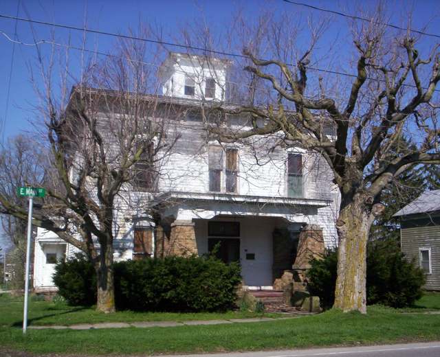
Photo: User:OHWiki, Wikimedia Commons, CC0 · Wikimedia Commons
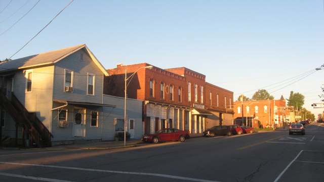
Photo: Nyttend, Wikimedia Commons, Public domain · Wikimedia Commons
Local history sources: richland.ohgenweb.org · en.wikipedia.org · en.wikipedia.org · en.wikipedia.org · en.wikipedia.org · richlandcountyhistory.com · commons.wikimedia.org · commons.wikimedia.org
Historic places
1 place in Shiloh on the National Register of Historic Places. Press a pin or a name for its whole record.
-
Ferrell, Silas, HouseBuilding · Shiloh · listed 1987
- Address
- 25 E. Main St.
- Where
- Shiloh, Richland County · ZIP 44878
- What it is
- Building
- Listed on the National Register
- 1987
- NRIS reference number
- 87002146
- Coordinates
- 40.96684, -82.59923
National Register file (NPS) ↗ Search Wikipedia ↗ Street map and directions ↗ On the Cracked Buckeye map
Source: National Park Service, National Register of Historic Places point file. The listing year is shown where NPS's certification date agrees with the listing's reference number. Listing recognizes significance; it does not restrict a private owner.
Water
Mostly private wells The water here
- Shiloh Village100% of residentsGroundwater wells (2 wells)
Hospitals, fire stations and more
Inside Shiloh's boundary: 1 fire or EMS station. Press a pin or a name for its whole record and its source.
Fire and EMS stations (1)
-
Cass Blooming Grove and Shiloh Fire DepartmentShiloh
- Address
- 11 North Delaware Street, Shiloh, OH 44878
- Coordinates
- 40.96881, -82.60440
USGS National Map structures (source) ↗ Street map and directions ↗
Source: USGS National Map structures (most Ohio records last updated 2019 to 2022), checked against the Columbus and Cleveland station lists. The department that answers a call is set by jurisdiction and mutual aid, not by distance.
Its ZIP codes
Each ZIP code that touches Shiloh, with the share of its residents who live here and the same headline figures as the ZIP page.
| ZIP | Share | Water | Radon | Home value | Schools | Flood |
|---|---|---|---|---|---|---|
| 44878 Bloominggrove Township and Shiloh | 19% | Mostly private wells | 5.2 pCi/L average radon | Median year built 1952 | Plymouth-Shiloh Local · 4 stars overall | 3.6% of residents in the 1% floodplain |
Local government
Who holds office in Shiloh, how its elections and ballot issues came out, and the state auditor's record.
Money issues on the ballot since 2016: 0 of 1 passed; of those asking for new or higher taxes, 0 of 1.
Ballot issues
| Date | Issue | For | Against | Result |
|---|---|---|---|---|
| 2016-03-15 | Issue: VILLAGE OF SHILOH-TAX LEVY- Replacement 2.5m 5Yrs-Current Expenses (2.5 mills, replacement) | 58 | 91 | Failed (38.93% for) |
Elections for office
| Date | Office | Candidates and votes |
|---|---|---|
| 2015-11-03 | Member of Council (number of seats not on file, so winners are not marked) | Johnny J. Shepherd 98, 36.98%; Shirley G. Reeder 92, 34.72%; April M. Fletcher 75, 28.3% |
| 2015-11-03 | Mayor | Marilyn Hall 99, 54.4%; Charles R. Reeder 82, 45.05%; Write-In 1, 0.55%; Ricky L. Shepherd 0 |
Winners in bold. Results from the county board of elections' official canvass unless marked.
Auditor of State record
- No fiscal caution, watch or emergency on the Auditor of State's lists.
- On the Auditor of State's unauditable list.
The county
Richland County: 12 ZIP codes, 27 cities, villages and townships, 124,341 people.
Nearby places
Rain and snow
How much has actually fallen on Shiloh, day by day, from 1893 to now. Daily totals, not averages.
- rain, last 30 days
- 1.80 in
- 2026-09-30 to 2026-10-29
- rain so far in 2026
- 39.8 in
- 3.9 in above normal for the date
- snow so far in 2026
- 21.0 in
- a normal year brings 36.9 in
- a normal year
- 42.3 in
- average of 30 years, 1991-2020
| Month | Rain (in) | Snow (in) | Days counted |
|---|---|---|---|
| October 2026 | 1.80 | — | 29 |
| September 2026 | 4.81 | — | 30 |
| August 2026 | 4.98 | — | 31 |
| July 2026 | 3.56 | — | 31 |
| June 2026 | 3.88 | — | 30 |
| May 2026 | 6.33 | — | 31 |
| April 2026 | 7.78 | — | 30 |
| March 2026 | 4.37 | 0.3 | 31 |
| February 2026 | 0.88 | 4.2 | 28 |
| January 2026 | 1.41 | 16.5 | 31 |
| December 2025 | 2.79 | 9.8 | 31 |
| November 2025 | 1.63 | 1.2 | 30 |
| Wettest year | 2011 — 57.5 in |
|---|---|
| Driest year | 1963 — 23.6 in |
| Snowiest year | 1910 — 63.1 in |
| Wettest day on record | 21 August 2007 — 5.20 in |
| Heaviest snowfall in a day | 1 March 1954 — 10.77 in |
| Deepest snow on the ground | 2 March 1900 — 23.02 in |
Estimated, not measured. No rain gauge has ever stood inside Shiloh, so every figure here is worked out from the gauges around it - the nearest ones weighted most. Treat them as close estimates rather than readings.
48,662 days of records, 1893-01-01 to 2026-10-29. Source: NOAA NCEI GHCN-Daily, 3,240 gauges in and around Ohio. A day is "gauged" when a gauge standing inside the boundary reported it, and the value is the mean of those gauges. Otherwise it is interpolated by inverse distance from every gauge reporting within 50 miles. Nothing is carried forward, back-filled or smoothed. Against NOAA nClimDiv county monthly precipitation over 136,848 complete county-months (checked 2026-10-31): correlation 0.9515, median absolute difference 0.217 in a month. Built 2026-10-31 from the Cracked Buckeye precipitation archive. Snow is the softer number — snowfall is measured by hand with a ruler, no agency publishes a gridded county snowfall series, and blowing snow defeats every observer.
Environmental permits and filings
What Ohio EPA has on file for Shiloh: permits, inspections, violations, cleanups and the state loans behind sewer and water work. Every line links to the agency's own document.
- facilities and sites on file
- 6
- those placed on the map inside Shiloh
| Program | Facilities and sites |
|---|---|
| State sewer loans | 2 |
| State water loans | 2 |
| Public drinking water | 1 |
| Sewer and water-line construction | 1 |
| Date | Facility or site | What |
|---|---|---|
| SHILOH VILLAGE OF PWS | Public drinking water violation resolved | |
| SHILOH VILLAGE OF PWS | Public drinking water compliance letter | |
| SHILOH VILLAGE OF PWS | Public drinking water notice of violation | |
| SHILOH VILLAGE OF PWS | Public drinking water report | |
| GB FABRICATION CO | Sewer and water-line construction inspection | |
| SHILOH VILLAGE OF PWS | Public drinking water notice of violation | |
| SHILOH VILLAGE OF PWS | Public drinking water inspection | |
| SHILOH VILLAGE OF PWS | Public drinking water plan | |
| SHILOH VILLAGE OF PWS | Public drinking water inspection | |
| SHILOH VILLAGE OF PWS | Public drinking water inspection | |
| SHILOH VILLAGE OF PWS | Public drinking water notice of violation | |
| SHILOH VILLAGE OF PWS | Public drinking water report | |
| SHILOH VILLAGE OF PWS | Public drinking water violation resolved | |
| SHILOH VILLAGE OF PWS | Public drinking water inspection | |
| SHILOH VILLAGE OF PWS | Public drinking water report | |
| SHILOH VILLAGE OF PWS | Public drinking water compliance letter | |
| SHILOH VILLAGE OF PWS | Public drinking water notice of violation | |
| SHILOH VILLAGE OF PWS | State water loans | |
| SHILOH VILLAGE OF PWS | Public drinking water inspection | |
| SHILOH VILLAGE OF PWS | Public drinking water notice of violation | |
| SHILOH VILLAGE OF PWS | Public drinking water report | |
| SHILOH VILLAGE OF PWS | Public drinking water inspection | |
| SHILOH VILLAGE OF PWS | Public drinking water notice of violation | |
| SHILOH VILLAGE OF PWS | State water loans | |
| SHILOH VILLAGE OF PWS | State water loans |
Source: Ohio EPA eDocument portal (edocpub.epa.ohio.gov), indexed 2026-10-14. Facilities are placed on the map from Ohio EPA's own map layers, EPA's Facility Registry, coordinates written in the filings, or a geocoded street address. A permit filed under a private person's name (most are household septic systems) is counted but never named, placed or linked; licenses for individual workers and open-burning notices are left out entirely.
Quick answers
What county is Shiloh, Ohio in?
Shiloh is a village in Richland County, Ohio, with 619 residents.
When was Shiloh, Ohio founded?
Shiloh was laid out September 1852; incorporated March 2, 1874. Founders on record: Charles R. Squires, who purchased the four-acre townsite and platted it as Salem Station. Source
How did Shiloh, Ohio get its name?
The station was first called Salem Station because of its proximity to the older village of Salem just to the north in Cass Township. Source
What ZIP code is Shiloh, Ohio?
Most of Shiloh is in ZIP code 44878.
Where does Shiloh, Ohio get its water?
The main water source for Shiloh (Shiloh Village): Mostly private wells.
Cite this page
Cite this page as:
Cracked Buckeye, "Shiloh, Richland County", https://crackedbuckeye.com/place/shiloh/, built 2026-10-31, accessed [date].
How to cite · Report a correction · Built 2026-10-31
