Local events in Springfield Township, Richland County
Nothing is posted for Springfield Township itself yet; here is what is on within 10 miles. All local events in Springfield Township, Richland County
Know a calendar we should watch? Send the link
Checked October 20; the events page is refreshed daily.
How Springfield Township, Richland County began
Springfield Township was organized in 1816 out of Madison Township, twelve miles east to west, taking in what became Sandusky Township and parts of Crawford County, and was cut to six miles square in February 1818. Mrs. Coffinberry, wife of one of the first settlers, suggested the name for its many springs; the Palmer Spring north of Ontario is the source of the Sandusky River, and a pond near Five Corners feeds both the Black Fork and the Clear Fork of the Mohican, on the divide between Lake Erie and the Ohio River. Settlers followed an old Indian trace into the northeast corner from 1814, built mills at Spring Mills and Millsborough, and in the 1840s and 1850s John Finney and Joseph Roe made the township a crossing point on the underground railroad. Today it surrounds Ontario and western Mansfield and is largely built out.
Settled 1814, incorporated 1816 (the 1870 county directory gives March 4, 1816; first election April 15, 1816), by organized from Madison Township; first settler George Coffinberry.
Where the name comes from
The name was suggested by Mrs. Coffinberry, of one of the first settler families, 'on account of the numerous springs within its limits', among them the Palmer, Preston and Condon springs and the springs at Spring Mills.
Before the town
Graham's 1880 county history says that when the township was settled Indian trails were the only highways, and that one of them passed Mill Springs (Spring Mills) on its way from the headwaters of the Rocky Fork to those of the Sandusky River; it was much used by the Wyandot, Lenape (Delaware) and Shawnee in their trading and war expeditions to the Ohio. Colonel William Crawford's column followed this trace in 1782, and the first settlers came in by it and settled first in the northeast corner. No mound, village or burial within the township is named. The Methodist Bigelow Chapel, built in 1837 two and a quarter miles north of Ontario, was founded mainly through the influence of a Rev. Mr. Bigelow, described as a missionary among the Wyandot.
Nations recorded here: Wyandot, Lenape (Delaware), Shawnee.
- Trace from the Rocky Fork to the Sandusky River (trail) — Past Mill Springs (Spring Mills) in the northeast part of the township, westward to the head of the Sandusky River, 18th century; followed by Crawford's column in 1782 and by the first settlers after 1814 (archive.org)
Timeline
- — Colonel William Crawford's militia column, tracking an existing Indian trace, is recorded as the first white men to cross the future township.
- — George Coffinberry, a Virginia-born Revolutionary War soldier, settles on the southeast quarter of Section 1.
- — Richard Condon builds his cabin on the northeast quarter of Section 2, and Joseph Welch the township's third cabin on Section 1.
- — Springfield Township is organized out of Madison Township, twelve miles long by six wide, including present Sandusky Township and parts of Polk and Jackson townships in Crawford County; at the first election, April 15, about twenty-five votes are cast and Richard Condon becomes the first justice of the peace.
- — Condon and Welch build the first sawmill, on the northwest quarter of Section 1; Graham names the township's first gristmill, undated, as the one built on the same section by later governor Mordecai Bartley, where Spring Mill stood in 1880.
- — In February the township is cut in two, leaving it six miles square; Joseph Welch builds its first brick house, and John Garretson builds mills on the head of the Clear Fork at what becomes Millsborough.
- — Robert Finney starts the township's first Sabbath school, meeting in the home of John Chambers.
- — A log Presbyterian church is built one mile north of Ontario at a crossroads called Five Corners.
- — Millsborough is laid out October 29 on Section 28 by deputy county surveyor John S. Marshall (a later local-history article says it was first laid out as Edwinsburgh in 1816); it has two dry-goods stores about 1830-35 but, bypassed by the railroads, is dead by 1880.
- — Bigelow Chapel, a Methodist frame church, is built two and a quarter miles north of Ontario on David Jaques's farm; a Baptist church follows across the road in 1844.
- — Men who disrupted an antislavery sermon in a township schoolhouse, cutting worshipers' saddles and bridles, are tried in Mansfield with Columbus Delano for the defense, and fined.
- — A Lutheran and German Reformed church, built the year before on the southwest quarter of Section 1, is organized; its Sunday school is called the Spring Mills Union Sunday School.
- — The Springfield Methodist Church is built on the southeast quarter of Section 26 for about $500.
- — The Watershed Barn, a barn between Ontario and Crestline whose roof split rain between Lake Erie and the Ohio River, draws visitors from around the state; it is demolished in the 1950s for U.S. Route 30.
Stories
Five Corners and the first Sabbath school
Before Springfield Township had a church building, it had a living room. In 1820 Robert Finney began holding the township's first Sabbath school in the private home of John Chambers, and for several years that was the only regular religious gathering in the area. The community's Presbyterian families eventually raised a log meetinghouse in 1822 at a crossroads a mile north of Ontario known locally as Five Corners. It was a modest start for a township that would, over the following century and a half, be absorbed almost entirely into the growing edge of Mansfield.
Uncle John Finney's granary
John Finney, son of Robert Finney, and his neighbor Joseph Roe kept stations on the underground railroad in Springfield Township for about twenty-five years, carrying fugitives by wagon to Savannah in Ashland County or to Oberlin, passing Mansfield before daylight. Once Benjamin Gass brought Finney five men and five or six women and children; Finney put the women upstairs in his house and the men in his granary. Six armed pursuers arrived, and three went to Mansfield for a warrant while Finney gave the other three breakfast and armed the men in the barn with pitchforks. The fugitives slipped out of the barn to the woods, and when the warrant came no one was found; Roe later moved the women to James Wood's house and led the pursuers off in the wrong direction, and all reached safety.
The barn on the divide
The ridge across Springfield Township divides waters bound for Lake Erie from waters bound for the Ohio River. The Palmer Spring, a mile and a half north of Ontario and about 123 feet higher than Crestline, is the source of the Sandusky River and was piped to Crestline for its waterworks. A pond near Five Corners sends the Black Fork north and the Clear Fork south, and between the two river sources stood the Craig barn, whose roof was said to split the rain between the two basins. An article titled 'The Divide' in the state archaeological and historical society's publications pictured the spot, and in 1903 the 'Watershed Barn' drew visitors from around Ohio by streetcar. It was torn down in the 1950s to make room for U.S. Route 30.
Photographs
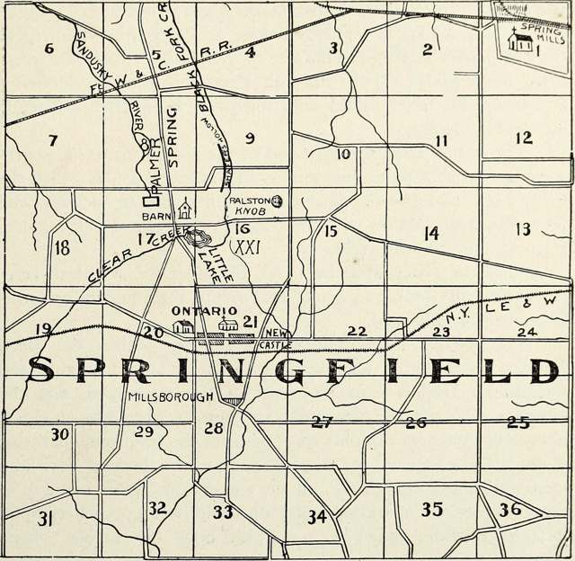
Photo: Ohio State Archaeological and Historical Society; Internet Archive Book Images, no known copyright restrictions · Wikimedia Commons
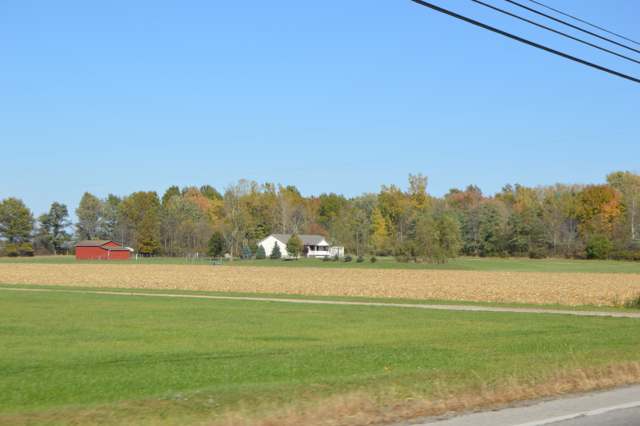
Photo: Wikimedia Commons contributor, Public domain · Wikimedia Commons
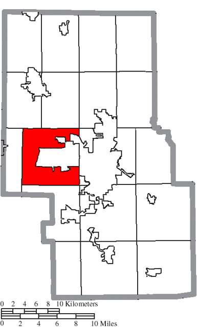
Photo: Ruhrfisch / Wikimedia Commons, CC BY-SA 3.0 · Wikimedia Commons
Local history sources: heritagepursuit.com · en.wikipedia.org · commons.wikimedia.org · archive.org · archive.org · archive.org · archive.org · archive.org · archive.org · archive.org · archive.org · archive.org · archive.org · richlandcountyhistory.com · richlandcountyhistory.com · commons.wikimedia.org
Water
Mostly private wells The water here
- Mansfield City63% of residentsClear Fork Reservoir (Clear Fork of the Mohican River), plus 9 city wells
- Ontario City18% of residentsGroundwater wells (3 wells)
- Crestline Village8% of residentsGroundwater wells (3 wells)
- Aqua Ohio - Mansfield System #012% of residentsGroundwater wells (2 wells)
- Aqua Ohio - Mansfield System #022% of residentsGroundwater wells (3 wells)
- Lakeview Estates MHP1% of residentsGroundwater wells (2 wells)
- Peyton Community Well1% of residentsGroundwater wells (1 wells)
- Eastview Community Water Association1% of residentsGroundwater wells (3 wells)
- Aqua Ohio - Mansfield System #031% of residentsGroundwater wells (1 wells)
- Madison Water District1% of residentsGroundwater wells (4 wells)
- Aqua Ohio - Mansfield System #080% of residentsGroundwater wells (1 wells)
- Hanley Acres Water Association0% of residentsGroundwater wells (2 wells)
- Willow Park Water Association0% of residentsGroundwater wells (2 wells)
- Briarwood Estates MHP0% of residentsGroundwater wells (2 wells)
- Hillside MHP0% of residentsGroundwater wells (1 wells)
Hospitals, fire stations and more
Inside Springfield Township, Richland County's boundary: 1 fire or EMS station, 2 poor-rated bridges, 1 Toxics Release Inventory facility and 4 spill cases. Press a pin or a name for its whole record and its source.
Fire and EMS stations (1)
-
Springfield Township Fire Department Station 2Ontario
- Address
- 400 South Lexington Springmill Road, Ontario, OH 44906
- Coordinates
- 40.74863, -82.59034
USGS National Map structures (source) ↗ Street map and directions ↗
Source: USGS National Map structures (most Ohio records last updated 2019 to 2022), checked against the Columbus and Cleveland station lists. The department that answers a call is set by jurisdiction and mutual aid, not by distance.
Bridges rated poor (2)
-
Marion Ave. Rd. over Clear Fork Mohican RiverPoor · built 1947
- Condition
- Poor: a deck, superstructure, substructure or culvert rated 4 or below on the 0 to 9 scale
- What it is
- Bridge
- Built
- 1947
- Length
- 13 ft
- Owner
- County
- Vehicles a day
- 1,199
- Coordinates
- 40.74342, -82.63910
National Bridge Inventory (source) ↗ Street map and directions ↗
-
Springmill West over Black Fork Mohican RiverPoor · built 1967
- Condition
- Poor: a deck, superstructure, substructure or culvert rated 4 or below on the 0 to 9 scale
- What it is
- Bridge
- Built
- 1967
- Length
- 9 ft
- Owner
- County
- Vehicles a day
- 477
- Coordinates
- 40.80441, -82.61664
National Bridge Inventory (source) ↗ Street map and directions ↗
Source: FHWA National Bridge Inventory 2025. "Poor" means one major part rated 4 or below on the 0 to 9 scale; it calls for repair, not closing, unless the state posts or closes the bridge.
Facilities reporting toxic releases (1)
-
Hunter Protective SystemsToxics Release Inventory · Mansfield
- Address
- 4080 Park Ave W, Mansfield, OH 44903
- County
- Richland County
- Status
- Reports to the Toxics Release Inventory (active)
- EPA program ID
- 44903HNTRP48PAR
- EPA registry ID
- 110009638981
EPA facility record ↗ EPA Facility Registry Service (source) ↗ Street map and directions ↗
Source: EPA Facility Registry Service, Toxics Release Inventory reporters. Reporting a release is required of large users of listed chemicals; it is not by itself a violation.
Spills reported since 2021 (4)
-
Fuel Diesel / Diesel Fuel (Vehicle On Or Off Road)2025-06-13 · Springfield Twp
- Reported
- 2025-06-13
- What spilled
- Fuel Diesel / Diesel Fuel (Vehicle On Or Off Road)
- Largest amount reported
- 140 gallons
- Where
- Springfield Twp, Richland County
- Ohio EPA district office
- NWDO
- Ohio EPA case number
- 2506EPA0000968
Ohio EPA spill reports (source) ↗ Street map and directions ↗
-
Fuel Diesel / Diesel Fuel (Vehicle On Or Off Road)2024-02-22 · Springfield Twp
- Reported
- 2024-02-22
- What spilled
- Fuel Diesel / Diesel Fuel (Vehicle On Or Off Road)
- Where
- Springfield Twp, Richland County
- Ohio EPA district office
- NWDO
- Ohio EPA case number
- 2402EPA0000272
Ohio EPA spill reports (source) ↗ Street map and directions ↗
-
Oil Hydraulic Fluid(S)2023-05-08 · Springfield Twp
- Reported
- 2023-05-08
- What spilled
- Oil Hydraulic Fluid(S)
- Largest amount reported
- 20 gallons
- Where
- Springfield Twp, Richland County
- Ohio EPA district office
- NWDO
- Ohio EPA case number
- 2305EPA0000738
Ohio EPA spill reports (source) ↗ Street map and directions ↗
-
Drum(S)2022-05-31 · Springfield Twp
- Reported
- 2022-05-31
- What spilled
- Drum(S); Fuel Diesel / Diesel Fuel (Vehicle On Or Off Road); Paint Waste(S)
- Largest amount reported
- 5,500 gallons
- Where
- Springfield Twp, Richland County
- Ohio EPA district office
- NWDO
- Ohio EPA case number
- 2205EPA0000797
Ohio EPA spill reports (source) ↗ Street map and directions ↗
Source: Ohio EPA emergency response spill reports, 2021 to September 2026, one point per case where Ohio EPA placed it. A report is what the caller or responder recorded; amounts are often blank or estimated.
Its ZIP codes
Each ZIP code that touches Springfield Township, Richland County, with the share of its residents who live here and the same headline figures as the ZIP page.
| ZIP | Share | Water | Radon | Home value | Schools | Flood |
|---|---|---|---|---|---|---|
| 44903 Mansfield | 12% | Mostly private wells | 4.5 pCi/L average radon | Median year built 1957 | Mansfield City · 3 stars overall | 2.1% of residents in the 1% floodplain |
| 44906 Mansfield | 7% | Clear Fork Reservoir, a 4.5-billion-gallon impoundment of the Clear Fork southwest of the treatment plant, supplemented by 9 city groundwater wells | 3.9 pCi/L average radon | Median year built 1958 | Mansfield City · 3 stars overall | 0.0% of residents in the 1% floodplain |
| 44827 Crestline | 4% | Groundwater wells (3 wells) | 5.7 pCi/L average radon | Median year built 1958 | Crestline Exempted Village · 2.5 stars overall | 9.0% of residents in the 1% floodplain |
Local government
Who holds office in Springfield Township, Richland County, how its elections and ballot issues came out, and the state auditor's record.
Money issues on the ballot since 2015: 2 of 2 passed.
Ballot issues
| Date | Issue | For | Against | Result |
|---|---|---|---|---|
| 2015-11-03 | Issue: Springfield Twp-Tax Levy-Renw'l-0.5M-5Yrs-Fire (0.5 mills, renewal) | 2,235 | 1,221 | Passed (64.67% for) |
| 2015-11-03 | Issue: Springfield Twp-Tax Levy-Renw'l-2M-5Yrs-Fire (2.0 mills, renewal) | 2,156 | 1,258 | Passed (63.15% for) |
Elections for office
| Date | Office | Candidates and votes |
|---|---|---|
| 2015-11-03 | Trustee | Robert W. Currens 2,183, 100.0% |
| 2015-11-03 | Fiscal Officer | Ted Koehler 2,001, 100.0% |
Winners in bold. Results from the county board of elections' official canvass unless marked.
Auditor of State record
- No fiscal caution, watch or emergency on the Auditor of State's lists.
- Financial Audit, 2023 to 2024, released 2026-01-27
The county
Richland County: 12 ZIP codes, 27 cities, villages and townships, 124,341 people.
Nearby places
Quick answers
What county is Springfield Township, Ohio in?
Springfield Township, Richland County is a township in Richland County, Ohio, with 4,408 residents.
When was Springfield Township, Ohio founded?
Springfield Township, Richland County was settled 1814; incorporated 1816 (the 1870 county directory gives March 4, 1816; first election April 15, 1816). Founders on record: organized from Madison Township; first settler George Coffinberry. Source
How did Springfield Township, Ohio get its name?
The name was suggested by Mrs. Source
What ZIP code is Springfield Township, Ohio?
Springfield Township, Richland County is served by ZIP codes 44903, 44906 and 44827; 44903 holds the largest share of its residents.
Where does Springfield Township, Ohio get its water?
The main water source for Springfield Township, Richland County (Mansfield City): Mostly private wells.
Cite this page
Cite this page as:
Cracked Buckeye, "Springfield Township, Richland County", https://crackedbuckeye.com/place/springfield-township-richland-county/, built 2026-10-31, accessed [date].
How to cite · Report a correction · Built 2026-10-31
