Local events in Lebanon
41 events in the next 90 days from 5 public calendars. All local events in Lebanon
Checked October 20; the events page is refreshed daily.
Lakes near Lebanon
The history under the water: the valley before, the dam, the stories. All Ohio lakes
Deep dives about Lebanon
Long reads built from maps, newspapers and public records. All deep dives
- Flock Cameras in OhioAbout 6,900 mapped plate readers in 80 Ohio counties: who runs them, who searched the data, the case for and against, and the bills before the legislature.
- The Adena, Ohio's first mound buildersOhio's Adena culture raised the state's first burial mounds around 800 BC. It is named for Thomas Worthington's Chillicothe estate.
History from Lebanon
People and inventions tied to this place, each with its sources. All people · All inventions
How Lebanon began
Lebanon was laid out in September 1802 by Ichabod Corwin, Silas Hurin, Ephraim Hathaway, and Samuel Manning on land along Turtle Creek that Corwin had settled in 1796, and it was named for the Biblical Lebanon because of the Eastern red cedars growing there, similar to the cedars of Lebanon. When Warren County was organized the following year, Lebanon became its seat, a role it has held ever since, and its weekly newspaper, the Western Star, has published continuously since 1807, making it one of Ohio's oldest. The town's best-known landmark, the Golden Lamb, opened as a tavern in 1803 and is the oldest continuously operating hotel in Ohio, having hosted twelve U.S. presidents along with Mark Twain, Charles Dickens, and Harriet Beecher Stowe. Lebanon grew steadily as a courthouse town and trading center through the nineteenth and twentieth centuries, and today its historic downtown, built up largely in the 1970s-through-1984 wave of National Register listings, anchors a city that has more than doubled in population since 1980 as Cincinnati's suburbs have spread northeast along the I-71 corridor.
Settled 1796, platted September 1802, by Ichabod Corwin, Silas Hurin, Ephraim Hathaway, and Samuel Manning.
Where the name comes from
The town was named after the Biblical land of Lebanon because Eastern red cedar (Juniperus virginiana) grew abundantly on the site, resembling the cedars of Lebanon referenced in scripture. The nickname "The Cedar City" is still used locally today.
Before the town
No mound, earthwork, or named historic-era village has been documented within Lebanon's own municipal boundary in the sources checked; the city's own NRHP-listed sites are all nineteenth-century buildings. The land was ceded to the United States by the Treaty of Greenville (August 3, 1795), signed at Fort Greenville between General Anthony Wayne and a confederation of nations led by Shawnee war chief Blue Jacket and Miami war chief Little Turtle; before that cession, southwestern Ohio including the future Warren County lay within Shawnee and Miami hunting and settlement territory, with the Shawnee concentrated along the Great and Little Miami and Scioto valleys. Warren County holds real prehistoric and historic-era sites nearby: Fort Ancient, a Hopewell-era hilltop earthwork enclosure and part of Ohio's Hopewell Ceremonial Earthworks UNESCO World Heritage inscription, sits along the Little Miami River near Oregonia in the county's east, well outside Lebanon; and Hamilton Township, immediately south, holds the Stubbs Earthworks (Ohio Hopewell, c. 100 BCE-AD 500) and the Moar Mound and Village (Late Woodland) near Morrow. No source consulted places a named village, trail, or treaty boundary inside Lebanon itself.
Nations recorded here: Shawnee, Miami, Hopewell culture.
Timeline
- — Ichabod Corwin, uncle of future Ohio governor and U.S. Senator Thomas Corwin, arrives from Bourbon County, Kentucky, and settles on the north branch of Turtle Creek, becoming the first white settler on the site of Lebanon.
- — In September, Silas Hurin, Ephraim Hathaway, Samuel Manning, and Ichabod Corwin lay out the town of Lebanon.
- — The Golden Lamb opens as a tavern and inn on South Broadway; Warren County is organized and Lebanon becomes its seat.
- — The Western Star newspaper begins publishing in Lebanon; it continues today as one of Ohio's oldest weekly papers.
- — The Golden Lamb is rebuilt; the present four-story brick structure at 27-31 S. Broadway dates from this rebuilding.
- — Amos Bennett builds Glendower, a Greek Revival mansion on Cincinnati Avenue (U.S. Route 42), for Lebanon merchant John Milton Williams.
- — The John Ferney House, a Greek Revival house at 475 Glosser Rd. designed by architect Joseph W. Cowan, is built.
- — Lebanon Academy opens at 190 New St. in a Greek Revival building with a pedimented roof and brick piers.
- — Glendower is listed on the National Register of Historic Places on November 10.
- — The Golden Lamb is listed on the National Register of Historic Places on January 12.
- — A single wave of nominations on October 10 adds the Goldsmith Coffeen House (419 Cincinnati Ave.), the Corwin House (1255 State Route 48), the Corwin-Bolin House (1443 State Route 48), the John Ferney House, Lebanon Academy, the Floraville and North Broadway historic districts, the Lebanon Commercial District, the Maplewood Sanitorium, and the Mohrman-Jack-Evans House to the National Register of Historic Places.
- — Lebanon launches a municipally owned cable, telephone and fiber-internet utility, offering residents service at rates reported to run up to half of private competitors' prices.
- — The City of Lebanon establishes its stormwater utility to address a backlog of stormwater infrastructure needs and comply with EPA-mandated stormwater quality requirements.
- — Lebanon sells its municipal telecommunications utility to Cincinnati Bell.
- — In fall, construction begins on roughly 40,000 feet of new water main and a pump station to bring Greater Cincinnati Water Works water from the Richard Miller Treatment Plant into Lebanon's system.
- — The city's population reaches 20,841 in the decennial census, more than two and a half times its 1970 population.
Stories
Ohio's oldest hotel
The Golden Lamb opened as a tavern on South Broadway in 1803, the same year Warren County was organized, and it has operated continuously ever since, making it the oldest hotel in Ohio. The current four-story brick building dates to an 1815 rebuilding. Over two centuries the inn has hosted twelve U.S. presidents -- among them William Henry Harrison, John Quincy Adams, Ulysses S. Grant, Rutherford B. Hayes, William McKinley, and William Howard Taft, all with Ohio ties -- along with literary visitors Charles Dickens, Mark Twain, and Harriet Beecher Stowe. Each of the inn's guest rooms is named for a notable visitor, and the building's upper floors, furnished with period antiques from the Warren County Historical Society, function as a small house museum even as the ground floor keeps serving as a working restaurant and hotel. Its listing on the National Register of Historic Places in 1978 recognized both the building and its unbroken run as a hospitality landmark since the town's founding year.
The Shaker curse
A persistent local legend holds that Lebanon's comparatively modest growth next to Cincinnati and Dayton traces back to a curse laid on the town by the Shakers of nearby Union Village, after a falling-out with Lebanon's townspeople. Union Village, founded around 1805 about four miles west of town, was one of the largest Shaker communities in the country at its peak, and the religious and cultural friction between the celibate, communal Shakers and their county-seat neighbors was real enough to leave a folk memory behind. There is no documentary evidence that any curse was actually pronounced, and the Shakers themselves thrived nearby. But the story has stuck, still told today as an explanation for why the county seat stayed a market town while its neighbors became cities.
A pink hexagon on Cincinnati Avenue
At 419 Cincinnati Avenue stands a small, six-sided pink house known locally as the "Hexagon House," built for the Goldsmith and Coffeen families and listed on the National Register of Historic Places in 1984. Hexagonal and octagonal house plans had a brief vogue in mid-nineteenth-century America, promoted by writers who argued the shape let in more light and required less material than a conventional rectangular house, and Lebanon's example is one of the more unusual survivors of that fad in southwestern Ohio. It sits a few blocks from Glendower, the 1836 Greek Revival mansion built for merchant John Milton Williams that is today operated as the Warren County Museum, giving Cincinnati Avenue two architectural oddities within easy walking distance of each other.
A city that sold its own cable company
In 1999 Lebanon did something almost no other Ohio city its size attempted: it built and operated its own cable television, telephone, and fiber-internet utility, competing directly with the private companies serving the rest of the region. For seven years the city-owned service reportedly saved subscribers as much as half of what competitors charged, a rare case of a small Midwestern county seat running a full triple-play telecom operation as a municipal utility, though the system struggled to recover its costs and ran up more than $8 million in debt. The experiment ended in 2006, when Lebanon sold the system to Cincinnati Bell, but for those years the town founded on cedar trees and a coach-stop tavern was also, briefly, in the business of laying fiber optic cable.
Photographs
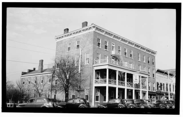
Photo: Historic American Buildings Survey (Library of Congress), photographers E.F. Schrand and A.R. Arend, public domain · Wikimedia Commons
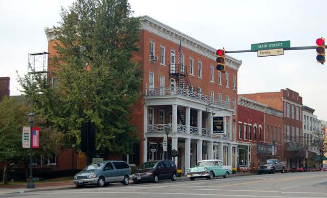
Photo: R.P. Piper (Wikimedia Commons user Zinzius), CC BY-SA 3.0 · Wikimedia Commons
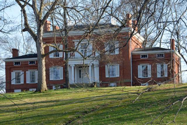
Photo: Floraville2, CC BY-SA 4.0 · Wikimedia Commons
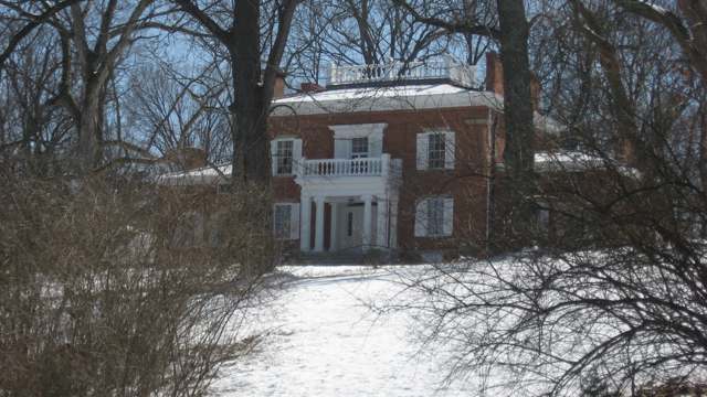
Photo: Nyttend, public domain · Wikimedia Commons
Local history sources: en.wikipedia.org · en.wikipedia.org · en.wikipedia.org · en.wikipedia.org · wcgsohio.org · npgallery.nps.gov · hmdb.org · en.wikipedia.org · en.wikipedia.org · ohioslargestplayground.com · en.wikipedia.org · commons.wikimedia.org · commons.wikimedia.org · commons.wikimedia.org · lebanonohio.gov · cincinnati-oh.gov
Historic places
13 places in Lebanon on the National Register of Historic Places. Press a pin or a name for its whole record.
-
Coffeen, Goldsmith, HouseBuilding · Lebanon · listed 1984
- Address
- 419 Cincinnati Ave.
- Where
- Lebanon, Warren County · ZIP 45036
- What it is
- Building
- Listed on the National Register
- 1984
- NRIS reference number
- 84000165
- Coordinates
- 39.42990, -84.21548
National Register file (NPS) ↗ Search Wikipedia ↗ Street map and directions ↗ On the Cracked Buckeye map
-
Corwin HouseBuilding · Lebanon · listed 1984
- Address
- 1255 OH 48
- Where
- Lebanon, Warren County · ZIP 45036
- What it is
- Building
- Listed on the National Register
- 1984
- NRIS reference number
- 84000166
- Coordinates
- 39.45425, -84.20521
National Register file (NPS) ↗ Search Wikipedia ↗ Street map and directions ↗ On the Cracked Buckeye map
-
Corwin-Bolin HouseBuilding · Lebanon · listed 1984
- Address
- 1443 OH 48
- Where
- Lebanon, Warren County · ZIP 45036
- What it is
- Building
- Listed on the National Register
- 1984
- NRIS reference number
- 84000167
- Coordinates
- 39.45543, -84.20575
National Register file (NPS) ↗ Search Wikipedia ↗ Street map and directions ↗ On the Cracked Buckeye map
-
Ferney, John, HouseBuilding · Lebanon · listed 1984
- Address
- 475 Glosser Rd.
- Where
- Lebanon, Warren County · ZIP 45036
- What it is
- Building
- Listed on the National Register
- 1984
- NRIS reference number
- 84000423
- Coordinates
- 39.42790, -84.22613
National Register file (NPS) ↗ Search Wikipedia ↗ Street map and directions ↗ On the Cracked Buckeye map
-
GlendowerBuilding · Lebanon · listed 1970
- Address
- U.S. 42 (Cincinnati Ave.)
- Where
- Lebanon, Warren County · ZIP 45036
- What it is
- Building
- Listed on the National Register
- 1970
- NRIS reference number
- 70000521
- Coordinates
- 39.43005, -84.21048
National Register file (NPS) ↗ Search Wikipedia ↗ Street map and directions ↗ On the Cracked Buckeye map
-
Golden LambBuilding · Lebanon · listed 1978
- Address
- 27--31 S. Broadway
- Where
- Lebanon, Warren County · ZIP 45036
- What it is
- Building
- Listed on the National Register
- 1978
- NRIS reference number
- 78002204
- Coordinates
- 39.43360, -84.20825
National Register file (NPS) ↗ Search Wikipedia ↗ Street map and directions ↗ On the Cracked Buckeye map
-
Lebanon AcademyBuilding · Lebanon · listed 1984
- Address
- 190 New St.
- Where
- Lebanon, Warren County · ZIP 45036
- What it is
- Building
- Listed on the National Register
- 1984
- NRIS reference number
- 84000427
- Coordinates
- 39.43910, -84.20466
National Register file (NPS) ↗ Search Wikipedia ↗ Street map and directions ↗ On the Cracked Buckeye map
-
Lebanon Cemetery Entrance ArchStructure · Lebanon · listed 1984
- Address
- Hunter St.
- Where
- Lebanon, Warren County · ZIP 45036
- What it is
- Structure
- Listed on the National Register
- 1984
- NRIS reference number
- 84000157
- Coordinates
- 39.43716, -84.21368
National Register file (NPS) ↗ Search Wikipedia ↗ Street map and directions ↗ On the Cracked Buckeye map
-
Lebanon Cemetery Superintendent's HouseBuilding · Lebanon · listed 1984
- Address
- 416 W. Silver St.
- Where
- Lebanon, Warren County · ZIP 45036
- What it is
- Building
- Listed on the National Register
- 1984
- NRIS reference number
- 84000159
- Coordinates
- 39.43607, -84.21349
National Register file (NPS) ↗ Search Wikipedia ↗ Street map and directions ↗ On the Cracked Buckeye map
-
Maplewood SanitoriumBuilding · Lebanon · listed 1984
- Address
- Maple and Deerfield Sts.
- Where
- Lebanon, Warren County · ZIP 45036
- What it is
- Building
- Listed on the National Register
- 1984
- NRIS reference number
- 84000432
- Coordinates
- 39.42528, -84.20695
National Register file (NPS) ↗ Search Wikipedia ↗ Street map and directions ↗ On the Cracked Buckeye map
-
Mohrman-Jack-Evans HouseBuilding · Lebanon · listed 1984
- Address
- 342 Columbus Ave.
- Where
- Lebanon, Warren County · ZIP 45036
- What it is
- Building
- Listed on the National Register
- 1984
- NRIS reference number
- 84000433
- Coordinates
- 39.43788, -84.19878
National Register file (NPS) ↗ Search Wikipedia ↗ Street map and directions ↗ On the Cracked Buckeye map
-
Smith-Davis HouseBuilding · Lebanon · listed 1985
- Address
- 206 W. Silver St.
- Where
- Lebanon, Warren County · ZIP 45036
- What it is
- Building
- Listed on the National Register
- 1985
- NRIS reference number
- 85000245
- Coordinates
- 39.43592, -84.21106
National Register file (NPS) ↗ Search Wikipedia ↗ Street map and directions ↗ On the Cracked Buckeye map
-
West Baptist ChurchBuilding · Lebanon · listed 1984
- Address
- 500 W. Mulberry St.
- Where
- Lebanon, Warren County · ZIP 45036
- What it is
- Building
- Listed on the National Register
- 1984
- NRIS reference number
- 84000161
- Coordinates
- 39.43519, -84.21422
National Register file (NPS) ↗ Search Wikipedia ↗ Street map and directions ↗ On the Cracked Buckeye map
Source: National Park Service, National Register of Historic Places point file. The listing year is shown where NPS's certification date agrees with the listing's reference number. Listing recognizes significance; it does not restrict a private owner.
Water
Ohio River intake at the plant's riverfront on Kellogg Ave in the California neighborhood, east Cincinnati The water here
- Lebanon City79% of residentsOhio River + Great Miami Aquifer (via Cincinnati GCWW)
- Western Water Company12% of residentsLittle Miami River valley wells (51%) plus Cincinnati Ohio River water (49%)
- Warren Co. Pennyroyal Area5% of residentsGreat Miami Buried Valley Aquifer (own wells)
- Cincinnati Public Water System4% of residentsOhio River (Miller Plant, ~88%) plus Great Miami Buried Valley Aquifer wells (~12%)
Hospitals, fire stations and more
Inside Lebanon's boundary: 1 hospital, 1 health center, 1 dialysis center, 2 nursing homes, 2 fire and EMS stations, 1 college, 6 public schools, 2 private schools, 1 poor-rated bridge, 1 library, 3 museums, 2 police stations, 5 public charging sites, 13 Toxics Release Inventory facilities and 10 spill cases. Press a pin or a name for its whole record and its source.
Hospitals (1)
-
Bethesda Arrow Springs-ErGeneral hospital · Lebanon
- What it is
- General hospital
- Address
- 100 Arrow Springs Blvd, Lebanon, OH 45036
- County
- Warren County
- Helipad
- Yes
- Phone
- (513) 282-7000
Hospital's website ↗ Where HIFLD got this record ↗ HIFLD hospitals (source) ↗ Street map and directions ↗
Source: HIFLD hospitals inventory via FEMA (closed hospitals it still lists left out, hospitals opened since added), with Medicare Care Compare ratings matched by name and address.
Community health centers (1)
-
HealthSource LebanonHealth center · Lebanon
- Run by
- a federally qualified health center
- Setting
- Clinic
- City
- Lebanon
- Coordinates
- 39.45136, -84.18299
Find a Health Center (HRSA) ↗ HRSA data (source) ↗ Street map and directions ↗
Source: HRSA health center service delivery sites, active, September 2026 (school-based sites left out). Health centers see patients whether or not they have insurance, with fees on a sliding scale.
Dialysis centers (1)
-
Davita Lebanon Dialysis CenterDialysis · Lebanon
- Address
- 918 B Columbus Avenue, Lebanon, OH 45036
- Dialysis stations
- 16
- Medicare star rating
- 4 of 5 stars
- Services
- in-center hemodialysis
- Ownership
- for profit
- Chain
- DaVita
- Medicare certified since
- 2008-01-01
- Phone
- (513) 934-0272
- Medicare ID
- 362707
Medicare Care Compare ↗ CMS dialysis facility list (source) ↗ Street map and directions ↗
Source: CMS dialysis facility list, September 2026, geocoded with the Census Bureau batch geocoder (an address it could not place sits at its ZIP center).
Nursing homes (2)
-
Cedars of Lebanon Care Center2 of 5 stars · Lebanon
- Address
- 102 East Silver Street, Lebanon, OH 45036
- Certified beds
- 45
- Residents on an average day
- 43
- Medicare overall rating
- 2 of 5 stars
- Health inspections
- 2 of 5 stars
- Staffing
- 3 of 5 stars
- Quality measures
- 4 of 5 stars
- Penalties since 2023
- none
- Ownership
- For profit - Limited Liability company
- Chain
- CCH HEALTHCARE
- Takes
- Medicare and Medicaid
- Phone
- (513) 932-0300
- Medicare ID
- 366296
Medicare Care Compare ↗ CMS nursing home data (source) ↗ Street map and directions ↗
-
Embassy of Lebanon2 of 5 stars · Lebanon
- Address
- 700 Monroe Road, Lebanon, OH 45036
- Certified beds
- 79
- Residents on an average day
- 60
- Medicare overall rating
- 2 of 5 stars
- Health inspections
- 1 of 5 stars
- Staffing
- 1 of 5 stars
- Quality measures
- 5 of 5 stars
- Penalties since 2023
- 1 fine totalling $197,584, 1 payment denial (latest 2023-08-23)
- Ownership
- For profit - Corporation
- Takes
- Medicare and Medicaid
- Phone
- (513) 932-0105
- Medicare ID
- 365920
Medicare Care Compare ↗ CMS nursing home data (source) ↗ Street map and directions ↗
Source: CMS Care Compare nursing home provider and penalties files; Medicare star ratings run 1 to 5.
Fire and EMS stations (2)
-
Lebanon Fire Station 42Lebanon
- Address
- 3116 Lebanon Road, Lebanon, OH 45036
- Coordinates
- 39.38906, -84.21442
USGS National Map structures (source) ↗ Street map and directions ↗
-
Lebanon Fire Station and Emergency Medical Services Station 41Lebanon
- Address
- 20 West Silver Street, Lebanon, OH 45036
- Coordinates
- 39.43584, -84.20923
USGS National Map structures (source) ↗ Street map and directions ↗
Source: USGS National Map structures (most Ohio records last updated 2019 to 2022), checked against the Columbus and Cleveland station lists. The department that answers a call is set by jurisdiction and mutual aid, not by distance.
Colleges (1)
-
Dental Assistant Pro-LebanonFor-profit career school · Lebanon
- What it is
- For-profit career school
- City
- Lebanon
- Students, 2023-24 (12-month count)
- 23
- IPEDS unit ID
- 452780
College Navigator (NCES) ↗ IPEDS data (source) ↗ Street map and directions ↗
Source: NCES IPEDS 2024 directory, 2023-24 enrollment and tuition, graduation rates for the 2017 (four-year) and 2020 (two-year) entering classes.
Public schools (6)
-
Berry Intermediate School4.5 of 5 stars · Lebanon
- Address
- 23 Oakwood Ave, Lebanon, OH 45036
- School district
- Lebanon City School District
- Kind (NCES)
- Regular School
- Students, 2023-24
- 838
- Teachers (full-time equivalent)
- 38
- Report card, 2025-26
- 4.5 of 5 stars
- Performance index
- 85.7%
- Ohio building IRN
- 002519
- NCES school ID
- 390442101144
NCES school record ↗ Ohio School Report Card ↗ Street map and directions ↗
-
Bowman Primary School4.5 of 5 stars · Lebanon
- Address
- 825 Hart Rd., Lebanon, OH 45036
- School district
- Lebanon City School District
- Kind (NCES)
- Regular School
- Students, 2023-24
- 1,171
- Teachers (full-time equivalent)
- 51
- Report card, 2025-26
- 4.5 of 5 stars
- Ohio building IRN
- 000491
- NCES school ID
- 390442104927
NCES school record ↗ Ohio School Report Card ↗ Street map and directions ↗
-
Donovan Elementary School4.5 of 5 stars · Lebanon
- Address
- 401 Justice Dr, Lebanon, OH 45036
- School district
- Lebanon City School District
- Kind (NCES)
- Regular School
- Students, 2023-24
- 788
- Teachers (full-time equivalent)
- 36
- Report card, 2025-26
- 4.5 of 5 stars
- Performance index
- 83.1%
- Ohio building IRN
- 095679
- NCES school ID
- 390442104304
NCES school record ↗ Ohio School Report Card ↗ Street map and directions ↗
-
Greater Ohio Virtual SchoolLebanon
- Address
- 1879 Deerfield Rd, Lebanon, OH 45036
- Kind (NCES)
- Regular School
- Students, 2023-24
- 580
- Teachers (full-time equivalent)
- 20.15
- NCES school ID
- 390048805198
-
Lebanon High School4.5 of 5 stars · Lebanon
- Address
- 1916 Drake Rd, Lebanon, OH 45036
- School district
- Lebanon City School District
- Kind (NCES)
- Regular School
- Students, 2023-24
- 1,574
- Teachers (full-time equivalent)
- 80
- Report card, 2025-26
- 4.5 of 5 stars
- Performance index
- 85.8%
- Four-year graduation rate
- 97.5%
- Ohio building IRN
- 020032
- NCES school ID
- 390442101146
NCES school record ↗ Ohio School Report Card ↗ Street map and directions ↗
-
Lebanon Junior High3 of 5 stars · Lebanon
- Address
- 160 Miller Rd, Lebanon, OH 45036
- School district
- Lebanon City School District
- Kind (NCES)
- Regular School
- Students, 2023-24
- 859
- Teachers (full-time equivalent)
- 43
- Report card, 2025-26
- 3 of 5 stars
- Performance index
- 80.2%
- Ohio building IRN
- 000493
- NCES school ID
- 390442104928
NCES school record ↗ Ohio School Report Card ↗ Street map and directions ↗
Source: NCES EDGE public school locations 2024-25 and Common Core of Data 2023-24 (type, students, teachers); Ohio School Report Cards 2025-26 (Department of Education and Workforce), matched by name within the district.
Private schools (2)
-
Lebanon United Methodist KindergartenPrivate, nonsectarian · Lebanon
- Address
- 122 E Silver St, Lebanon, OH 45036
- Kind
- nonsectarian
- Students, 2023-24
- 12
- Teachers (full-time equivalent)
- 2
- Students per teacher
- 6
- Phone
- (513) 933-0567
- NCES private school ID
- K9304409
-
St Francis De Sales SchoolPrivate, Catholic · Lebanon
- Address
- 20 Desales Ave, Lebanon, OH 45036
- Kind
- Catholic
- Students, 2023-24
- 161
- Teachers (full-time equivalent)
- 14.8
- Students per teacher
- 10.8784
- Phone
- (513) 932-6501
- NCES private school ID
- 01056824
Source: NCES Private School Survey 2023-24.
Bridges rated poor (1)
-
Kingsview Drive over Turtle CreekPoor · built 1985
- Condition
- Poor: a deck, superstructure, substructure or culvert rated 4 or below on the 0 to 9 scale
- What it is
- Bridge
- Built
- 1985
- Length
- 70 ft
- Owner
- City
- Vehicles a day
- 910
- Coordinates
- 39.38103, -84.23820
National Bridge Inventory (source) ↗ Street map and directions ↗
Source: FHWA National Bridge Inventory 2025. "Poor" means one major part rated 4 or below on the 0 to 9 scale; it calls for repair, not closing, unless the state posts or closes the bridge.
Public libraries (1)
-
Lebanon Public LibraryCentral library · Lebanon
- Address
- 101 S. Broadway, Lebanon, OH 45036
- What it is
- Central library
- Library system
- Lebanon Public Library
- Open
- 3,001 hours a year, 52 weeks
- Building
- 19,047 sq ft
- System's visits, FY2024
- 149,500
- System's loans, FY2024
- 653,150
- People the system serves
- 44,127
- Phone
- (513) 932-2665
IMLS Public Libraries Survey (source) ↗ Street map and directions ↗
Source: IMLS Public Libraries Survey FY2024 (outlets and their systems). Any Ohio resident can get a free card at any Ohio public library.
Museums, historical societies, gardens and zoos (3)
-
Glendower Museum Ohio Historical SocietyHistorical society · Lebanon
- What it is
- Historical society
- City
- Lebanon
- Coordinates
- 39.43068, -84.21330
Search Wikipedia ↗ IMLS Museum Data Files (source) ↗ Street map and directions ↗
The museum list is IMLS's 2018 file; a museum may have closed or moved since.
-
Lebanon Conservancy FoundationHistorical society · Lebanon
- What it is
- Historical society
- City
- Lebanon
- Coordinates
- 39.44601, -84.20500
Search Wikipedia ↗ IMLS Museum Data Files (source) ↗ Street map and directions ↗
The museum list is IMLS's 2018 file; a museum may have closed or moved since.
-
Warren County Historical SocietyHistorical society · Lebanon
- What it is
- Historical society
- City
- Lebanon
- Coordinates
- 39.43557, -84.20821
Search Wikipedia ↗ IMLS Museum Data Files (source) ↗ Street map and directions ↗
The museum list is IMLS's 2018 file; a museum may have closed or moved since.
Source: IMLS Museum Data Files, 2018.
Police stations (2)
-
Lebanon Division of Police StationLebanon
- Address
- 25 West Silver Street, Lebanon, OH 45036-2027
- Coordinates
- 39.43537, -84.20910
USGS National Map structures (source) ↗ Street map and directions ↗
-
Warren County Sheriff's OfficeLebanon
- Address
- 550 Justice Drive Suite 2, Lebanon, OH 45036-2377
- Coordinates
- 39.42629, -84.19899
USGS National Map structures (source) ↗ Street map and directions ↗
Source: USGS National Map structures, police stations, corrected and completed by hand (September 2026). The department that answers a call is set by jurisdiction, not by distance.
Public EV charging (5)
-
CITY OF LEBANON STATION #12 Level 2 · Lebanon
- Address
- 125 S Sycamore St, Lebanon, OH 45036
- Ports
- 2 Level 2
- Plugs
- J1772
- Network
- ChargePoint Network
- Hours
- 24 hours daily
- Phone
- 888-758-4389
Station Locator (NREL) ↗ Alternative Fuels Data Center (source) ↗ Street map and directions ↗
-
Cronin CDJR DC fast2 DC fast · 2 Level 2 · Lebanon
- Address
- 951 West Main Street, Lebanon, OH 45036
- Ports
- 2 DC fast · 2 Level 2
- Plugs
- CCS, J1772
- Network
- Blink Network
- Hours
- 24 hours daily
- Phone
- 888-998-2546
Station Locator (NREL) ↗ Alternative Fuels Data Center (source) ↗ Street map and directions ↗
-
First National Bank2 Level 2 · Lebanon
- Address
- 1000 E Main St., Lebanon, OH 45036
- Ports
- 2 Level 2
- Plugs
- J1772
- Network
- FLO
- Hours
- 24 hours daily
- Phone
- 888-356-8911
Station Locator (NREL) ↗ Alternative Fuels Data Center (source) ↗ Street map and directions ↗
-
Golden Lamb3 Level 2 · Lebanon
- Address
- 27 S Broadway Street, Lebanon, OH 45036
- Ports
- 3 Level 2
- Plugs
- J1772
- Network
- FLO
- Hours
- 24 hours daily
- Phone
- 888-356-8911
Station Locator (NREL) ↗ Alternative Fuels Data Center (source) ↗ Street map and directions ↗
-
Jake Sweeney Lebanon DC fast2 DC fast · Lebanon
- Address
- 917 Columbus Avenue, Lebanon, OH 45036
- Ports
- 2 DC fast
- Plugs
- CCS
- Network
- Blink Network
- Hours
- 24 hours daily
- Phone
- 888-998-2546
Station Locator (NREL) ↗ Alternative Fuels Data Center (source) ↗ Street map and directions ↗
Source: NREL Alternative Fuels Data Center station list (May 2026), public and open stations, the posts at one address counted as one site.
Facilities reporting toxic releases (13)
-
Advics Manufacturing of Ohio IncToxics Release Inventory · Lebanon
- Address
- 1650 Kingsview Drive, Lebanon, OH 45036
- County
- Warren County
- Status
- Reports to the Toxics Release Inventory (active)
- EPA program ID
- 45036LCSSM1650K
- EPA registry ID
- 110000392389
EPA facility record ↗ EPA Facility Registry Service (source) ↗ Street map and directions ↗
-
Amtex IncToxics Release Inventory · Lebanon
- Address
- 1500 Kingsview Dr., Lebanon, OH 45036
- County
- Warren County
- Status
- Reports to the Toxics Release Inventory (active)
- EPA program ID
- 45036MTXNC1500K
- EPA registry ID
- 110000392405
EPA facility record ↗ EPA Facility Registry Service (source) ↗ Street map and directions ↗
-
Compositite IncToxics Release Inventory · Lebanon
- Address
- 265 S West St, Lebanon, OH 45036
- County
- Warren County
- Status
- Reports to the Toxics Release Inventory (active)
- EPA program ID
- 45036CMPST265SW
- EPA registry ID
- 110004681782
EPA facility record ↗ EPA Facility Registry Service (source) ↗ Street map and directions ↗
-
Design Evolution 4 IncToxics Release Inventory · Lebanon
- Address
- 1004 W. Main St., Lebanon, OH 45036
- County
- Warren County
- Status
- Reports to the Toxics Release Inventory (active)
- EPA program ID
- 45036DSGNV1004W
- EPA registry ID
- 110000392361
EPA facility record ↗ EPA Facility Registry Service (source) ↗ Street map and directions ↗
-
Fecon LlcToxics Release Inventory · Lebanon
- Address
- 3460 Grant Dr, Lebanon, OH 45036
- County
- Warren County
- Status
- Reports to the Toxics Release Inventory
- EPA program ID
- 4503WFCNLL346GR
- EPA registry ID
- 110070296147
EPA facility record ↗ EPA Facility Registry Service (source) ↗ Street map and directions ↗
-
Flint Group Packaging Ink (1483060398)Toxics Release Inventory · Lebanon
- Address
- 2675 Henkle Dr., Lebanon, OH 45036
- County
- Warren County
- Status
- Reports to the Toxics Release Inventory (active)
- EPA program ID
- 45036FLNTN2675H
- EPA registry ID
- 110002112730
EPA facility record ↗ EPA Facility Registry Service (source) ↗ Street map and directions ↗
-
Ghent ManufacturingToxics Release Inventory · Lebanon
- Address
- 2999 Henkle Dr, Lebanon, OH 45036
- County
- Warren County County
- Status
- Reports to the Toxics Release Inventory
- EPA program ID
- 4503WGHNTM2999H
- EPA registry ID
- 110070890464
EPA facility record ↗ EPA Facility Registry Service (source) ↗ Street map and directions ↗
-
Gmi Companies IncToxics Release Inventory · Lebanon
- Address
- 2999 Henkle Dr, Lebanon, OH 45036
- County
- Warren County County
- Status
- Reports to the Toxics Release Inventory (open)
- EPA program ID
- 45036GHNTM2999H
- EPA registry ID
- 110004717897
EPA facility record ↗ EPA Facility Registry Service (source) ↗ Street map and directions ↗
-
Hunting Specialized Prods, IncToxics Release Inventory · Lebanon
- Address
- 42 E Mulberry St, Suite A, Lebanon, OH 45036
- County
- Warren County
- Status
- Reports to the Toxics Release Inventory (closed)
- EPA program ID
- 45036HNTNG265SW
- EPA registry ID
- 110002112749
EPA facility record ↗ EPA Facility Registry Service (source) ↗ Street map and directions ↗
-
Inx International Ink CoToxics Release Inventory · Lebanon
- Address
- 350 Homan Rd, Lebanon, OH 45036
- County
- Warren County
- Status
- Reports to the Toxics Release Inventory
- EPA program ID
- 4503WNXNTR35HMA
- EPA registry ID
- 110063690901
EPA facility record ↗ EPA Facility Registry Service (source) ↗ Street map and directions ↗
-
Midmark Corporation (1483060076)Toxics Release Inventory · Lebanon
- Address
- 360 Harmon Avenue, Lebanon, OH 45036
- County
- Warren County
- Status
- Reports to the Toxics Release Inventory (active)
- EPA program ID
- 45036SCHMD360HA
- EPA registry ID
- 110001626688
EPA facility record ↗ EPA Facility Registry Service (source) ↗ Street map and directions ↗
-
Qg, LlcToxics Release Inventory · Lebanon
- Address
- 760 Fujitec Drive, Lebanon, OH 45036
- County
- Warren County
- Status
- Reports to the Toxics Release Inventory (closed)
- EPA program ID
- 45036JHNSN760FU
- EPA registry ID
- 110000392370
EPA facility record ↗ EPA Facility Registry Service (source) ↗ Street map and directions ↗
-
Sumitomo Electric Wiring Systems IncToxics Release Inventory · Lebanon
- Address
- 3800 Columbia Rd., Lebanon, OH 45036
- County
- Warren County
- Status
- Reports to the Toxics Release Inventory (active)
- EPA program ID
- 45036SMTML3800C
- EPA registry ID
- 110000392414
EPA facility record ↗ EPA Facility Registry Service (source) ↗ Street map and directions ↗
Source: EPA Facility Registry Service, Toxics Release Inventory reporters. Reporting a release is required of large users of listed chemicals; it is not by itself a violation.
Spills reported since 2021 (10)
-
Oil Hydraulic Fluid(S)2025-06-23 · Lebanon
- Reported
- 2025-06-23
- What spilled
- Oil Hydraulic Fluid(S)
- Largest amount reported
- 40 gallons
- Where
- Lebanon, Warren County
- Ohio EPA district office
- SWDO
- Ohio EPA case number
- 2506EPA0001040
Ohio EPA spill reports (source) ↗ Street map and directions ↗
-
Oil Hydraulic Fluid(S)2025-06-08 · Lebanon
- Reported
- 2025-06-08
- What spilled
- Oil Hydraulic Fluid(S)
- Largest amount reported
- 30 gallons
- Where
- Lebanon, Warren County
- Ohio EPA district office
- SWDO
- Ohio EPA case number
- 2506EPA0000934
Ohio EPA spill reports (source) ↗ Street map and directions ↗
-
Fuel Diesel / Diesel Fuel (Vehicle On Or Off Road)2025-04-24 · Lebanon
- Reported
- 2025-04-24
- What spilled
- Fuel Diesel / Diesel Fuel (Vehicle On Or Off Road)
- Largest amount reported
- 55 gallons
- Where
- Lebanon, Warren County
- Ohio EPA district office
- SWDO
- Ohio EPA case number
- 2504EPA0000635
Ohio EPA spill reports (source) ↗ Street map and directions ↗
-
Freon2024-07-18 · Lebanon
- Reported
- 2024-07-18
- What spilled
- Freon; Oil Cutting /Cutting Oil / Coolant / Lubricant; Sludge (Non-Sewage)
- Where
- Lebanon, Warren County
- Ohio EPA district office
- SWDO
- Ohio EPA case number
- 2407EPA0001227
Ohio EPA spill reports (source) ↗ Street map and directions ↗
-
Foam2023-04-11 · Lebanon
- Reported
- 2023-04-11
- What spilled
- Foam
- Largest amount reported
- 20 gallons
- Where
- Lebanon, Warren County
- Ohio EPA district office
- SWDO
- Ohio EPA case number
- 2304EPA0000554
Ohio EPA spill reports (source) ↗ Street map and directions ↗
-
Lead (Pb)2022-09-09 · Lebanon
- Reported
- 2022-09-09
- What spilled
- Lead (Pb)
- Where
- Lebanon, Warren County
- Ohio EPA district office
- SWDO
- Ohio EPA case number
- 2209EPA0001385
Ohio EPA spill reports (source) ↗ Street map and directions ↗
-
Solvent(S)2022-05-12 · Lebanon
- Reported
- 2022-05-12
- What spilled
- Solvent(S)
- Where
- Lebanon, Warren County
- Ohio EPA district office
- SWDO
- Ohio EPA case number
- 2205EPA0000681
Ohio EPA spill reports (source) ↗ Street map and directions ↗
-
Fuel Diesel / Diesel Fuel (Vehicle On Or Off Road)2022-02-17 · Turtle Creek Twp
- Reported
- 2022-02-17
- What spilled
- Fuel Diesel / Diesel Fuel (Vehicle On Or Off Road)
- Where
- Turtle Creek Twp, Warren County
- Ohio EPA district office
- SWDO
- Ohio EPA case number
- 2202EPA0000191
Ohio EPA spill reports (source) ↗ Street map and directions ↗
-
Other / All Other / Trade Name / Mixture / Solution Etc2021-01-12 · Lebanon
- Reported
- 2021-01-12
- What spilled
- Other / All Other / Trade Name / Mixture / Solution Etc
- Where
- Lebanon, Warren County
- Ohio EPA district office
- SWDO
- Ohio EPA case number
- 2101EPA0000040
Ohio EPA spill reports (source) ↗ Street map and directions ↗
-
Fuel Gasoline ( 25% Ethanol Not E85)2026-01-16 · Lebanon
- Reported
- 2026-01-16
- What spilled
- Fuel Gasoline ( 25% Ethanol Not E85); Antifreeze Vehicle Cooling
- Largest amount reported
- 25 gallons
- Where
- Lebanon, Warren County
- Ohio EPA district office
- SWDO
- Ohio EPA case number
- 2601EPA0000063
Ohio EPA spill reports (source) ↗ Street map and directions ↗
Source: Ohio EPA emergency response spill reports, 2021 to September 2026, one point per case where Ohio EPA placed it. A report is what the caller or responder recorded; amounts are often blank or estimated.
Its ZIP codes
Each ZIP code that touches Lebanon, with the share of its residents who live here and the same headline figures as the ZIP page.
| ZIP | Share | Water | Radon | Home value | Schools | Flood |
|---|---|---|---|---|---|---|
| 45036 Lebanon | 51% | Ohio River intake at the plant's riverfront on Kellogg Ave in the California neighborhood, east Cincinnati | 4.2 pCi/L average radon | Appraisal records without year built | Lebanon City · 4.5 stars overall | 3.5% of residents in the 1% floodplain |
Local government
Who holds office in Lebanon, how its elections and ballot issues came out, and the state auditor's record.
Money issues on the ballot since 2018: 1 of 2 passed; of those asking for new or higher taxes, 0 of 1.
Ballot issues
| Date | Issue | For | Against | Result |
|---|---|---|---|---|
| 2019-05-07 | Issue 4: Proposed Tax Levy (Additional) Lebanon City SD | 2,296 | 2,930 | Failed (43.93% for) |
| 2018-11-06 | Issue 3: 3 City of Lebanon Tax Levy Fire | 4,641 | 3,304 | Passed (58.41% for) |
| 2015-11-03 | Issue 8: 8 Lebanon City Income 0.25% Increase | 2,158 | 3,428 | Failed (38.63% for) |
Elections for office
| Date | Office | Candidates and votes |
|---|---|---|
| 2017-11-07 | Member of Council | Amy Brewer 2,291, 22.66%; Doug Shope 1,867, 18.47%; Krista R. Wyatt 1,713, 16.94%; Wendy Monroe 1,580, 15.63%; Paula Cramer 1,483, 14.67%; Ryan Tasseff 1,176, 11.63% |
| 2015-11-03 | Member of Council | Mark Messer 2,921, 23.25%; James A. Dearie 2,270, 18.07%; Jeffrey Aylor 2,150, 17.11%; Matthew Rodriguez 2,079, 16.55%; Raymond E. Miller, III 1,983, 15.78%; Kevin Robbins 1,162, 9.25% |
Winners in bold. Results from the county board of elections' official canvass unless marked.
Auditor of State record
- No fiscal caution, watch or emergency on the Auditor of State's lists.
- Financial Health Indicators (the Auditor of State's 17 measures; critical / cautionary / positive): 2020 0 / 2 / 15; 2021 0 / 1 / 16; 2022 1 / 3 / 13; 2023 0 / 1 / 16; 2024 0 / 1 / 16; 2025 0 / 1 / 15.
- Financial Audit, 2024, released 2026-06-23
- Financial Audit, 2023, released 2025-10-16
- OP&F Examination, 2023, released 2025-04-22
The county
Warren County: 12 ZIP codes, 24 cities, villages and townships, 222,825 people.
Nearby places
Rain and snow
How much has actually fallen on Lebanon, day by day, from 1893 to now. Daily totals, not averages.
- rain, last 30 days
- 0.85 in
- 2026-09-30 to 2026-10-29
- rain so far in 2026
- 44.6 in
- 6.8 in above normal for the date
- snow so far in 2026
- 17.1 in
- a normal year brings 16.4 in
- a normal year
- 44.5 in
- average of 30 years, 1991-2020
| Month | Rain (in) | Snow (in) | Days counted |
|---|---|---|---|
| October 2026 | 0.85 | — | 29 |
| September 2026 | 6.01 | — | 30 |
| August 2026 | 7.60 | — | 31 |
| July 2026 | 3.40 | — | 31 |
| June 2026 | 4.71 | — | 30 |
| May 2026 | 6.69 | — | 31 |
| April 2026 | 4.08 | — | 30 |
| March 2026 | 8.10 | 0.6 | 31 |
| February 2026 | 1.59 | 5.1 | 28 |
| January 2026 | 1.55 | 11.5 | 31 |
| December 2025 | 2.62 | 11.4 | 31 |
| November 2025 | 3.71 | 2.5 | 30 |
| Wettest year | 2011 — 63.4 in |
|---|---|
| Driest year | 1934 — 22.4 in |
| Snowiest year | 1906 — 53.9 in |
| Wettest day on record | 6 October 1910 — 6.76 in |
| Heaviest snowfall in a day | 23 March 1968 — 11.06 in |
| Deepest snow on the ground | 25 January 1894 — 20.00 in |
Mostly estimated. Only 6% of these days come from a gauge standing inside Lebanon - the rest are worked out from the nearest gauges around it, so read them as close estimates rather than readings.
48,876 days of records, 1893-01-01 to 2026-10-29. Source: NOAA NCEI GHCN-Daily, 3,240 gauges in and around Ohio. A day is "gauged" when a gauge standing inside the boundary reported it, and the value is the mean of those gauges. Otherwise it is interpolated by inverse distance from every gauge reporting within 50 miles. Nothing is carried forward, back-filled or smoothed. Against NOAA nClimDiv county monthly precipitation over 136,848 complete county-months (checked 2026-10-31): correlation 0.9515, median absolute difference 0.217 in a month. Built 2026-10-31 from the Cracked Buckeye precipitation archive. Snow is the softer number — snowfall is measured by hand with a ruler, no agency publishes a gridded county snowfall series, and blowing snow defeats every observer.
Environmental permits and filings
What Ohio EPA has on file for Lebanon: permits, inspections, violations, cleanups and the state loans behind sewer and water work. Every line links to the agency's own document.
- facilities and sites on file
- 82
- those placed on the map inside Lebanon
Data centers, power and big tech here. Ohio EPA files that name a data-center company, a power plant or substation, or a large technology firm:
- AMP BTM 2 LEBANON - COLUMBIA SUBSTATION (air pollution, latest Sep 3, 2025)
- AMP BTM 2 LEBANON - MONROE SUBSTATION (air pollution, latest Sep 3, 2025)
- CYRUSONE LLC - LEBANON DATA CTR (air pollution, latest Jan 14, 2025)
- LEBANON CITY POWER PLANT (air pollution, latest Jun 7, 2019)
| Program | Facilities and sites |
|---|---|
| Wastewater and stormwater discharge | 26 |
| Air pollution | 20 |
| Hazardous waste | 14 |
| Sewer and water-line construction | 11 |
| Public drinking water | 4 |
| Cessation Of Regulated Operations | 1 |
| Landfills | 1 |
| Scrap tires | 1 |
| Source-water protection | 1 |
| State sewer loans | 1 |
| Underground injection wells | 1 |
| Wetland and stream fill | 1 |
| Date | Facility or site | What |
|---|---|---|
| LEBANON CITY PWS | Public drinking water plan | |
| LEBANON CITY PWS | Public drinking water plan | |
| WILKENS BLVD TOWNHOMES | Sewer and water-line construction permit | |
| WILKENS BLVD TOWNHOMES | Sewer and water-line construction permit | |
| GHENT MANUFACTURING INC | Air pollution permit | |
| RAROCK FARM SUBDIVISION PHASE 3 | Wastewater and stormwater discharge permit | |
| LEBANON CITY PWS | Public drinking water plan | |
| PFB MANUFACTURING LLC | Air pollution permit | |
| GHENT MANUFACTURING INC | Air pollution permit | |
| MANE INC | Wastewater and stormwater discharge permit | |
| MANE INC | Wastewater and stormwater discharge permit | |
| LEBANON CITY PWS | Public drinking water plan | |
| CEDAR WOODS SUBDIVISION SECTION 5 | Wastewater and stormwater discharge permit | |
| PFB MANUFACTURING LLC | Wastewater and stormwater discharge notice of violation | |
| PFB MANUFACTURING LLC | Air pollution permit | |
| LEBANON CITY PWS | Public drinking water plan | |
| PARKSIDE AT LEBANON - PHASE 7 | Wastewater and stormwater discharge permit | |
| RAROCK FARM SUBDIVISION PHASE 1 AND 2 | Wastewater and stormwater discharge permit | |
| LEBANON CITY PWS | Public drinking water plan | |
| DUKE ENERGY 5484 GLT PROJECT | Wastewater and stormwater discharge permit | |
| LEBANON CITY PWS | Public drinking water report | |
| J & N DISTRIBUTION AND DESIGN INC | Air pollution report | |
| GHENT MANUFACTURING INC | Air pollution report | |
| DONS BODY SHOP | Air pollution report | |
| HAYASHI TELEMPU - NORTH AMERICA | Air pollution report |
Source: Ohio EPA eDocument portal (edocpub.epa.ohio.gov), indexed 2026-10-14. Facilities are placed on the map from Ohio EPA's own map layers, EPA's Facility Registry, coordinates written in the filings, or a geocoded street address. A permit filed under a private person's name (most are household septic systems) is counted but never named, placed or linked; licenses for individual workers and open-burning notices are left out entirely.
Quick answers
What county is Lebanon, Ohio in?
Lebanon is a city in Warren County, Ohio, with 21,025 residents.
When was Lebanon, Ohio founded?
Lebanon was settled 1796; laid out September 1802. Founders on record: Ichabod Corwin, Silas Hurin, Ephraim Hathaway, and Samuel Manning. Source
How did Lebanon, Ohio get its name?
The town was named after the Biblical land of Lebanon because Eastern red cedar (Juniperus virginiana) grew abundantly on the site, resembling the cedars of Lebanon referenced in scripture. Source
What ZIP code is Lebanon, Ohio?
Most of Lebanon is in ZIP code 45036.
Where does Lebanon, Ohio get its water?
The main water source for Lebanon (Lebanon City): Ohio River intake at the plant's riverfront on Kellogg Ave in the California neighborhood, east Cincinnati.
Cite this page
Cite this page as:
Cracked Buckeye, "Lebanon, Warren County", https://crackedbuckeye.com/place/lebanon/, built 2026-10-31, accessed [date].
How to cite · Report a correction · Built 2026-10-31
