Local events in Deerfield Township, Warren County
Nothing is posted for Deerfield Township itself yet; here is what is on within 10 miles. All local events in Deerfield Township, Warren County
Know a calendar we should watch? Send the link
Checked October 20; the events page is refreshed daily.
How Deerfield Township, Warren County began
Deerfield Township was organized in 1797 under Hamilton County (before Warren County was formed in 1803) and named for a large original township that itself was named for deer-licks — saline springs in the area that drew deer and made it a hunting ground before white settlement. The first settlement dates to 1795; the original township once covered nearly all of present-day Warren County plus slivers of Butler, Montgomery, Greene, Clinton and Hamilton counties, and in 1799 the territorial legislature tried and failed to make it a county of its own. The modern township sits in Warren County's southwest corner along the Little Miami River, and its identity is bound up with the company town of Kings Mills, built around the King Powder Company and its successor the Peters Cartridge Company. Today it is the most heavily developed township in the county, its farmland reworked into Kings Mills, Landen, Socialville, Fosters, Snidercrest, Loveland Park and part of Mason.
Settled 1795, incorporated 1797 (organized under Hamilton County); re-established May 10, 1803 as one of Warren County's original four townships, by early settlers including William Mounts (Mount's Station, on the Little Miami, c. 1795) and David Sutton, described as the township's most prominent pioneer.
Where the name comes from
The township took its name from deer-licks: saline springs within its bounds that attracted deer and made the area a hunting ground. An 1882 local history describes three such licks — one north of Mason, one called "The Deer Park" south of Mason where settlers built log barriers to trap deer, and a third south of Socialville. The name was fixed around 1796, when a much larger Deerfield Township under Hamilton County covered most of what is now Warren County.
Before the town
No historic Native village, treaty boundary, or documented encounter specific to this township turned up in the sources checked. The broader Warren County picture includes Shawnee and other nations' presence along the Little Miami. What is documented here is prehistoric: the Landen Mounds (Landen Mounds I and II), a pair of earthworks near Socialville-Foster Road on the north side of Landen Lake, west of Fosters, listed on the National Register of Historic Places on May 27, 1975 as an archaeological site. The 1882 local history also notes "impenetrable" forest crossed by Native American trails still visible a century after settlement began, but does not name the trails or the people who used them. No source consulted assigns the Landen Mounds to a specific culture (Adena or Hopewell); that identification was not found and is not asserted here.
- Landen Mounds I and II (mound) — near Socialville-Foster Road, north side of Landen Lake, west of Fosters, Deerfield Township, prehistoric (culture not specified in sources found) (en.wikipedia.org)
Timeline
- — First settlement in the area that became Deerfield Township; William Mounts establishes Mount's Station on the east side of the Little Miami River around this time.
- — Hamilton County commissioners organize Deerfield Township, at that time an enormous township covering nearly all of present-day Warren County and parts of four neighboring counties; Benjamin Stites Jr. and Isaac Lindley are appointed assessor and constable/tax collector on June 10.
- — The Northwest Territory legislature votes to elevate Deerfield to county status; Governor Arthur St. Clair vetoes the measure.
- — Warren County is formed and Deerfield Township is organized on May 10 as one of its original four townships, its territory now much reduced from the earlier Hamilton County township of the same name.
- — Gainsboro, a town platted on the site of what later became Kings Mills, fails to develop.
- — A post office named Twenty Mile Stand opens at a stagecoach stop 20 miles from downtown Cincinnati, in what is now southeastern Deerfield Township; it operates (renamed Twentymile Stand in 1895) until 1904.
- — J. W. King and his nephew Ahimaaz King build the Great Western Powder Works on the Little Miami River at the site of an old grist mill, founding the company town that becomes Kings Mills.
- — The Ahimaaz King House, an Italianate brick mansion built of clay fired from the Little Miami River, is completed overlooking Kings Mills.
- — Gershom Moore Peters, a former preacher, founds the Peters Cartridge Company in Kings Mills to manufacture shotgun shells and cartridges.
- — On July 15, a collision of loaded railway cars being shunted at the Kings Mills powder works triggers an explosion that kills 12 people and destroys the railroad station, freight house, office buildings, the shell factory, the cartridge loading plant, a warehouse and six residences.
- — Remington Arms purchases the Peters Cartridge Company.
- — A second explosion of unknown origin at the Kings Mills plant shatters windows as far as 30 miles away.
- — Remington ends cartridge production at Kings Mills and sells the facility to Columbia Records, which manufactures phonograph records there until 1949.
- — The Peters Cartridge Company complex is listed on the National Register of Historic Places on October 10.
- — The Ahimaaz King House at 1720 E. King Ave. in Kings Mills is listed on the National Register of Historic Places on December 19.
- — EPA declares the former Peters Cartridge Factory site a Superfund site because of lead and other contamination from a century of ammunition manufacturing.
- — The Twenty Mile House, the original stagecoach-stop tavern building at Twenty Mile Stand, is demolished in April and replaced by a strip mall and gas station.
- — Cartridge Brewing opens October 31 in the restored Peters Cartridge Company factory complex, alongside apartments built into the historic structures.
Stories
The township the governor vetoed
By 1799 Deerfield Township — then an enormous jurisdiction under Hamilton County covering nearly all of what would become Warren County — had grown so populous and so productive in tax receipts that it ranked fourth among all Hamilton County townships. Its residents petitioned the Northwest Territory's legislature to be split off as a county of its own. The legislature agreed and passed the measure, but Governor Arthur St. Clair, who held veto power over the territorial assembly, refused to sign it. Warren County would not be carved out of Hamilton County until 1803, four years later, under a different governor and a different process — and when it was, Deerfield became one of its four founding townships rather than a county in its own right.
A powder town on the Little Miami
In 1877, J. W. King and his nephew Ahimaaz King built the Great Western Powder Works on the Little Miami River, on the site of an old grist mill, after selling their earlier Miami Powder Company. The mill town that grew up around the works took the family's name: Kings Mills. Ahimaaz King went on to build an eight-room brick school and helped found what became the Kings Local School District, while overlooking the town from an Italianate mansion built of brick fired from river clay, completed in 1885. In 1887 a former preacher, Gershom Moore Peters, founded a second works next door, the Peters Cartridge Company, which by 1889 was turning out four thousand cartridges an hour. The two powder-and-cartridge works made Kings Mills what it was for the better part of a century, until Remington Arms bought Peters Cartridge in 1934 and shut down cartridge-making there ten years later.
The 1890 explosion
On July 15, 1890, loaded railway cars being shunted at the powder works in Kings Mills collided. The collision set off an explosion that killed twelve people and leveled much of the works: the railroad station, the freight house, office buildings, the shell factory, the cartridge loading plant, a warehouse, and six nearby residences were all destroyed. It was the worst single disaster in the plant's history, though a second, unexplained explosion in 1942 was powerful enough to shatter windows thirty miles away. The company rebuilt each time and kept operating into the 1940s.
Twenty miles from Cincinnati
In 1819 a post office opened at a stagecoach stop twenty miles up the road from downtown Cincinnati, in what is now the southeastern part of Deerfield Township. Travelers knew the stop by the distance itself: Twenty Mile Stand. A tavern building there, the Twenty Mile House, served coach passengers, then later generations of local residents, as a restaurant, bar and tavern for close to two centuries. The post office lasted until 1904, but the tavern building itself outlasted it by more than a century — it was not torn down until April 2013, when it was replaced by a strip mall and a gas station. The old name survives today as Landen's neighboring community, Twenty Mile Stand, and as Twenty Mile Stand Nature Preserve nearby.
Photographs
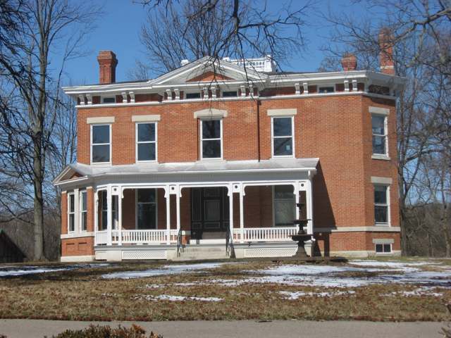
Photo: Nyttend, public domain · Wikimedia Commons
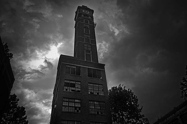
Photo: Samuel W. Smith, CC BY 4.0 · Wikimedia Commons
Local history sources: en.wikipedia.org · warren.ohgenweb.org · warren.ohgenweb.org · en.wikipedia.org · en.wikipedia.org · en.wikipedia.org · en.wikipedia.org · hmdb.org · commons.wikimedia.org · commons.wikimedia.org
Historic places
1 place in Deerfield Township, Warren County on the National Register of Historic Places. Press a pin or a name for its whole record.
-
King, Ahimaaz, HouseBuilding · Kings Mills · listed 2008
- Address
- 1720 E. King Ave.
- Where
- Kings Mills, Warren County · ZIP 45034
- What it is
- Building
- Listed on the National Register
- 2008
- NRIS reference number
- 08001199
- Coordinates
- 39.35852, -84.24695
National Register file (NPS) ↗ Search Wikipedia ↗ Street map and directions ↗ On the Cracked Buckeye map
Source: National Park Service, National Register of Historic Places point file. The listing year is shown where NPS's certification date agrees with the listing's reference number. Listing recognizes significance; it does not restrict a private owner.
Water
17 groundwater wells drawing from the Little Miami River buried valley (sand-and-gravel) aquifer along the river near Maineville, in southern Warren County The water here
- Cincinnati Public Water System39% of residentsOhio River (Miller Plant, ~88%) plus Great Miami Buried Valley Aquifer wells (~12%)
- Warren County27% of residentsWells in the Little Miami and Great Miami river valley aquifers
- Warren Co. Socialville16% of residentsOhio River (Miller Plant, ~88%) plus Great Miami Buried Valley Aquifer wells (~12%)
- Clermont Public Water System10% of residentsWilliam H. Harsha Lake plus wells in the Little Miami River and Ohio River aquifers
- Loveland City5% of residentsLocal wells (Betty Ray well field, sand & gravel aquifer)
- Butler Co. Water District 22% of residentsHamilton wells (Great Miami aquifer) + Cincinnati (Ohio River + wells)
- Western Water Company1% of residentsLittle Miami River valley wells (51%) plus Cincinnati Ohio River water (49%)
- Indian Hill City0% of residentsLittle Miami River valley aquifer (wells near Milford)
Hospitals, fire stations and more
Inside Deerfield Township, Warren County's boundary: 2 dialysis centers, 3 fire and EMS stations, 1 high-hazard dam, 6 public schools, 4 private schools, 11 public charging sites, 1 Superfund site, 1 Toxics Release Inventory facility and 12 spill cases. Press a pin or a name for its whole record and its source.
Dialysis centers (2)
-
Davita Loveland DialysisDialysis · Loveland
- Address
- 8944 Columbia Rd Suite 6, Loveland, OH 45140
- Dialysis stations
- 13
- Medicare star rating
- 3 of 5 stars
- Services
- in-center hemodialysis
- Ownership
- for profit
- Chain
- DaVita
- Medicare certified since
- 2018-05-31
- Phone
- (513) 583-5326
- Medicare ID
- 362872
Medicare Care Compare ↗ CMS dialysis facility list (source) ↗ Street map and directions ↗
-
Fmc - Kings MillsDialysis · Kings Mills
- Address
- 1992 King Avenue, Kings Mills, OH 45034
- Dialysis stations
- 12
- Medicare star rating
- 1 of 5 stars
- Services
- in-center hemodialysis
- Ownership
- for profit
- Chain
- Fresenius Medical Care
- Medicare certified since
- 2008-09-23
- Phone
- (513) 204-5555
- Medicare ID
- 362725
Medicare Care Compare ↗ CMS dialysis facility list (source) ↗ Street map and directions ↗
Source: CMS dialysis facility list, September 2026, geocoded with the Census Bureau batch geocoder (an address it could not place sits at its ZIP center).
Fire and EMS stations (3)
-
Deerfield Township Fire Rescue Station 56Mason
- Address
- 8395 Snider Road, Mason, OH 45040
- Coordinates
- 39.31690, -84.33218
USGS National Map structures (source) ↗ Street map and directions ↗
-
Deerfield Township Fire Rescue Station 58Mason
- Address
- 2095 Kings Mills Road, Mason, OH 45040
- Coordinates
- 39.35664, -84.25490
USGS National Map structures (source) ↗ Street map and directions ↗
-
Deerfield Township Fire Station 57Loveland
- Address
- 3435 US Route 22, Loveland, OH 45140
- Coordinates
- 39.30105, -84.28501
USGS National Map structures (source) ↗ Street map and directions ↗
Source: USGS National Map structures (most Ohio records last updated 2019 to 2022), checked against the Columbus and Cleveland station lists. The department that answers a call is set by jurisdiction and mutual aid, not by distance.
High-hazard dams (1)
-
Landen Farm Lake DamSimpson Creek · condition: satisfactory
- Hazard class
- High: a failure would probably cost a life
- Condition
- Satisfactory (assessed 03/13/2025)
- River or stream
- Simpson Creek
- Purpose
- Recreation
- Type
- Earth
- Height
- 40 ft
- Storage
- 1,400 acre-feet
- Completed
- 1975
- Owner type
- Private
- County
- Warren County
- Nearest town (NID)
- Foster
- Last inspection
- 05/08/2024
- Emergency action plan
- Yes
- NID ID
- OH00540
National Inventory of Dams record ↗ National Inventory of Dams (source) ↗ Street map and directions ↗
Source: U.S. Army Corps of Engineers National Inventory of Dams, August 2026. "High hazard" rates what a failure would cost downstream, not how likely one is; the condition is the state's assessment.
Public schools (6)
-
Columbia Intermediate School4.5 of 5 stars · Kings Mills
- Address
- 8263 Columbia Rd, Kings Mills, OH 45034
- School district
- Kings Local School District
- Kind (NCES)
- Regular School
- Students, 2023-24
- 768
- Teachers (full-time equivalent)
- 36.33
- Report card, 2025-26
- 4.5 of 5 stars
- Performance index
- 84.6%
- Ohio building IRN
- 124875
- NCES school ID
- 390504300921
NCES school record ↗ Ohio School Report Card ↗ Street map and directions ↗
-
J F Burns Elementary School5 of 5 stars · Kings Mills
- Address
- 8471 Columbia Rd, Kings Mills, OH 45034
- School district
- Kings Local School District
- Kind (NCES)
- Regular School
- Students, 2023-24
- 803
- Teachers (full-time equivalent)
- 38.5
- Report card, 2025-26
- 5 of 5 stars
- Performance index
- 88.2%
- Ohio building IRN
- 017541
- NCES school ID
- 390504303942
NCES school record ↗ Ohio School Report Card ↗ Street map and directions ↗
-
Kings High School4.5 of 5 stars · Kings Mills
- Address
- 5500 Columbia Rd, Kings Mills, OH 45034
- School district
- Kings Local School District
- Kind (NCES)
- Regular School
- Students, 2023-24
- 1,425
- Teachers (full-time equivalent)
- 55.22
- Report card, 2025-26
- 4.5 of 5 stars
- Performance index
- 86.3%
- Four-year graduation rate
- 97.2%
- Ohio building IRN
- 098640
- NCES school ID
- 390504304356
NCES school record ↗ Ohio School Report Card ↗ Street map and directions ↗
-
Kings Junior High School4 of 5 stars · Kings Mills
- Address
- 5620 Columbia Rd, Kings Mills, OH 45034
- School district
- Kings Local School District
- Kind (NCES)
- Regular School
- Students, 2023-24
- 733
- Teachers (full-time equivalent)
- 35.32
- Report card, 2025-26
- 4 of 5 stars
- Performance index
- 88%
- Ohio building IRN
- 019075
- NCES school ID
- 390504303943
NCES school record ↗ Ohio School Report Card ↗ Street map and directions ↗
-
Kings Mills Educational CenterKings Mills
- Address
- 1797 Kings Mills Rd, Kings Mills, OH 45034
- Kind (NCES)
- Regular School
- Students, 2023-24
- 191
- Teachers (full-time equivalent)
- 5.5
- NCES school ID
- 390504305862
-
Kings Mills Elementary School4.5 of 5 stars · Kings Mills
- Address
- 1780 King Ave, Kings Mills, OH 45034
- School district
- Kings Local School District
- Kind (NCES)
- Regular School
- Students, 2023-24
- 529
- Teachers (full-time equivalent)
- 24.5
- Report card, 2025-26
- 4.5 of 5 stars
- Performance index
- 92.9%
- Ohio building IRN
- 019083
- NCES school ID
- 390504303944
NCES school record ↗ Ohio School Report Card ↗ Street map and directions ↗
Source: NCES EDGE public school locations 2024-25 and Common Core of Data 2023-24 (type, students, teachers); Ohio School Report Cards 2025-26 (Department of Education and Workforce), matched by name within the district.
Private schools (4)
-
King of Kings Preschool and KindergartenPrivate, religious, denomination-affiliated · Mason
- Address
- 3621 Socialville Foster Rd, Mason, OH 45040
- Kind
- religious, denomination-affiliated
- Students, 2023-24
- 11
- Teachers (full-time equivalent)
- 1.6
- Students per teacher
- 6.875
- Phone
- (513) 398-6089
- NCES private school ID
- A0108647
-
Liberty Bible AcademyPrivate, religious, independent · Mason
- Address
- 4900 Old Irwin Simpson Rd, Mason, OH 45040
- Kind
- religious, independent
- Students, 2023-24
- 310
- Teachers (full-time equivalent)
- 22.4
- Students per teacher
- 13.8393
- Phone
- (513) 754-1234
- NCES private school ID
- A9300724
-
Montessori Academy of CincinnatiPrivate, nonsectarian, special program · Mason
- Address
- 8293 Duke Blvd, Mason, OH 45040
- Kind
- nonsectarian, special program
- Students, 2023-24
- 158
- Teachers (full-time equivalent)
- 18.8
- Students per teacher
- 8.40426
- Phone
- (513) 398-7773
- NCES private school ID
- A1302547
-
Montessori Academy of CincinnatiPrivate, nonsectarian, special program · Mason
- Address
- 8293 Duke Blvd, Mason, OH 45040
- Kind
- nonsectarian, special program
- Students, 2023-24
- 158
- Teachers (full-time equivalent)
- 19.3
- Students per teacher
- 8.18653
- Phone
- (513) 398-7773
- NCES private school ID
- A9503213
Source: NCES Private School Survey 2023-24.
Public EV charging (11)
-
Holiday Inn Express And Suites Cincinnati-Mason - Tesla Destination4 Level 2 · Mason
- Address
- 5100 Natorp Blvd, Mason, OH 45040
- Ports
- 4 Level 2
- Plugs
- J1772
- Network
- Tesla Destination
- Phone
- 877-798-3752
Station Locator (NREL) ↗ Alternative Fuels Data Center (source) ↗ Street map and directions ↗
-
HP Gov Pointe4 Level 2 · Mason
- Address
- 4605 Duke Drive, Mason, OH 45040
- Ports
- 4 Level 2
- Plugs
- J1772
- Network
- Blink Network
- Hours
- 24 hours daily
- Phone
- 888-998-2546
Station Locator (NREL) ↗ Alternative Fuels Data Center (source) ↗ Street map and directions ↗
-
Kings Chrysler Jeep Dodge Ram2 Level 2 · Cincinnati
- Address
- 4486 Kings Water Dr, Cincinnati, OH 45249
- Ports
- 2 Level 2
- Plugs
- J1772
- Network
- Non-Networked
- Hours
- Dealership business hours
- Phone
- 513-683-3000
Station Locator (NREL) ↗ Alternative Fuels Data Center (source) ↗ Street map and directions ↗
-
Kings Dodge, Inc.2 Level 2 · Cincinnati
- Address
- 4486 Kings Water Drive, Cincinnati, OH 45249
- Ports
- 2 Level 2
- Plugs
- J1772
- Network
- Blink Network
- Hours
- 24 hours daily
- Phone
- 888-998-2546
Station Locator (NREL) ↗ Alternative Fuels Data Center (source) ↗ Street map and directions ↗
-
KINGS FORD, INC FORD L2 PUBLIC24 Level 2 · Cincinnati
- Address
- 9555 Kings Auto Mall Road, Cincinnati, OH 45249
- Ports
- 4 Level 2
- Plugs
- J1772
- Network
- ChargePoint Network
- Hours
- 24 hours daily
- Phone
- 888-758-4389
Station Locator (NREL) ↗ Alternative Fuels Data Center (source) ↗ Street map and directions ↗
-
KINGS FORD, INC FORD L3 PUBLIC1 DC fast2 DC fast · Cincinnati
- Address
- 9555 Kings Automall Drive, Cincinnati, OH 45249
- Ports
- 2 DC fast
- Plugs
- CCS
- Network
- ChargePoint Network
- Hours
- 24 hours daily
- Phone
- 888-758-4389
Station Locator (NREL) ↗ Alternative Fuels Data Center (source) ↗ Street map and directions ↗
-
Latitude - 5245 Natorp2 Level 2 · Mason
- Address
- 5245 Natrop Blvd, Mason, OH 45040
- Ports
- 2 Level 2
- Plugs
- J1772
- Network
- FLO
- Hours
- 24 hours daily
- Phone
- 888-356-8911
Station Locator (NREL) ↗ Alternative Fuels Data Center (source) ↗ Street map and directions ↗
-
Latitude - 5265 Natorp2 Level 2 · Mason
- Address
- 5265 Natrop Blvd, Mason, OH 45040
- Ports
- 2 Level 2
- Plugs
- J1772
- Network
- FLO
- Hours
- 24 hours daily
- Phone
- 888-356-8911
Station Locator (NREL) ↗ Alternative Fuels Data Center (source) ↗ Street map and directions ↗
-
McCluskey Chevrolet6 Level 2 · Cincinnati
- Address
- 9673 Kings Automall Dr, Cincinnati, OH 45249
- Ports
- 6 Level 2
- Plugs
- J1772
- Network
- Non-Networked
- Hours
- 24 hours daily
- Price
- Free
- Phone
- 513-697-5200
Station Locator (NREL) ↗ Alternative Fuels Data Center (source) ↗ Street map and directions ↗
-
Meijer - Tesla Supercharger DC fast16 DC fast · Loveland
- Address
- 3911 US-22, Loveland, OH 45140
- Ports
- 16 DC fast
- Plugs
- Tesla (NACS)
- Network
- Tesla
- Hours
- 24 hours daily. Please check Tesla's online station map to see if an adapter is required at this location.
- Phone
- 877-798-3752
Station Locator (NREL) ↗ Alternative Fuels Data Center (source) ↗ Street map and directions ↗
-
Palmera Apartments6 Level 2 · Mason
- Address
- 6965 Palmera Dr, Mason, OH 45040
- Ports
- 6 Level 2
- Plugs
- J1772
- Network
- FLO
- Hours
- 24 hours daily
- Phone
- 888-356-8911
Station Locator (NREL) ↗ Alternative Fuels Data Center (source) ↗ Street map and directions ↗
Source: NREL Alternative Fuels Data Center station list (May 2026), public and open stations, the posts at one address counted as one site.
Superfund sites (1)
-
Kings Mills Lead SiteSuperfund program · Kings Mills
- Address
- 5620 Columbia Rd, Kings Mills, OH 45034
- County
- Warren County
- Status
- Superfund program site, not on the National Priorities List
- EPA program ID
- OHN000508990
- EPA registry ID
- 110006263177
EPA facility record ↗ EPA Facility Registry Service (source) ↗ Street map and directions ↗
Source: EPA Facility Registry Service, Superfund (SEMS) and National Priorities List sites. Many program sites were assessed and needed no cleanup.
Facilities reporting toxic releases (1)
-
Epic TechnologiesToxics Release Inventory · Mason
- Address
- 4240 Irwin Simpson Rd, Mason, OH 45040
- County
- Warren County
- Status
- Reports to the Toxics Release Inventory (active)
- EPA program ID
- 4504WPCTCH424IR
- EPA registry ID
- 110060261899
EPA facility record ↗ EPA Facility Registry Service (source) ↗ Street map and directions ↗
Source: EPA Facility Registry Service, Toxics Release Inventory reporters. Reporting a release is required of large users of listed chemicals; it is not by itself a violation.
Spills reported since 2021 (12)
-
Fuel Diesel / Diesel Fuel (Vehicle On Or Off Road)2025-12-11 · Deerfield Twp
- Reported
- 2025-12-11
- What spilled
- Fuel Diesel / Diesel Fuel (Vehicle On Or Off Road)
- Largest amount reported
- 30 gallons
- Where
- Deerfield Twp, Warren County
- Ohio EPA district office
- SWDO
- Ohio EPA case number
- 2512EPA0001985
Ohio EPA spill reports (source) ↗ Street map and directions ↗
-
Sheen Rainbow / Hydrocarbon2025-02-02 · Deerfield Twp
- Reported
- 2025-02-02
- What spilled
- Sheen Rainbow / Hydrocarbon; Fuel Diesel / Diesel Fuel (Vehicle On Or Off Road)
- Where
- Deerfield Twp, Warren County
- Ohio EPA district office
- SWDO
- Ohio EPA case number
- 2502EPA0000137
Ohio EPA spill reports (source) ↗ Street map and directions ↗
-
Material Unknown2024-10-08 · Deerfield Twp
- Reported
- 2024-10-08
- What spilled
- Material Unknown
- Where
- Deerfield Twp, Warren County
- Ohio EPA district office
- SWDO
- Ohio EPA case number
- 2410EPA0001721
Ohio EPA spill reports (source) ↗ Street map and directions ↗
-
Oil Petroleum Not Otherwise Specified (Nos)2024-10-07 · Deerfield Twp
- Reported
- 2024-10-07
- What spilled
- Oil Petroleum Not Otherwise Specified (Nos)
- Where
- Deerfield Twp, Warren County
- Ohio EPA district office
- SWDO
- Ohio EPA case number
- 2410EPA0001709
Ohio EPA spill reports (source) ↗ Street map and directions ↗
-
Mercury / Quicksilver (Hg)2024-06-19 · Deerfield Twp
- Reported
- 2024-06-19
- What spilled
- Mercury / Quicksilver (Hg)
- Where
- Deerfield Twp, Warren County
- Ohio EPA district office
- SWDO
- Ohio EPA case number
- 2406EPA0001035
Ohio EPA spill reports (source) ↗ Street map and directions ↗
-
Material Unknown Reached water2023-08-30 · Deerfield Twp
- Reported
- 2023-08-30
- What spilled
- Material Unknown
- Reached a waterway
- 83 - Simpson Creek
- Where
- Deerfield Twp, Warren County
- Ohio EPA district office
- SWDO
- Ohio EPA case number
- 2308EPA0001534
Ohio EPA spill reports (source) ↗ Street map and directions ↗
-
Fuel Gasoline ( 25% Ethanol Not E85)2022-09-23 · Mason
- Reported
- 2022-09-23
- What spilled
- Fuel Gasoline ( 25% Ethanol Not E85)
- Largest amount reported
- 10 gallons
- Where
- Mason, Warren County
- Ohio EPA district office
- SWDO
- Ohio EPA case number
- 2209EPA0001458
Ohio EPA spill reports (source) ↗ Street map and directions ↗
-
Material Green Reached water2022-08-22 · Deerfield Twp
- Reported
- 2022-08-22
- What spilled
- Material Green
- Reached a waterway
- 83 - Simpson Creek
- Where
- Deerfield Twp, Warren County
- Ohio EPA district office
- SWDO
- Ohio EPA case number
- 2208EPA0001292
Ohio EPA spill reports (source) ↗ Street map and directions ↗
-
Fuel Diesel / Diesel Fuel (Vehicle On Or Off Road) Reached water2022-06-17 · Deerfield Twp
- Reported
- 2022-06-17
- What spilled
- Fuel Diesel / Diesel Fuel (Vehicle On Or Off Road)
- Reached a waterway
- 99 - Unnamed
- Where
- Deerfield Twp, Warren County
- Ohio EPA district office
- SWDO
- Ohio EPA case number
- 2206EPA0000909
Ohio EPA spill reports (source) ↗ Street map and directions ↗
-
Antifreeze Vehicle Cooling2021-09-02 · Deerfield Twp
- Reported
- 2021-09-02
- What spilled
- Antifreeze Vehicle Cooling
- Largest amount reported
- 7 gallons
- Where
- Deerfield Twp, Warren County
- Ohio EPA district office
- SWDO
- Ohio EPA case number
- 2109EPA0001395
Ohio EPA spill reports (source) ↗ Street map and directions ↗
-
Material Unknown Reached water2026-06-18 · Deerfield Twp
- Reported
- 2026-06-18
- What spilled
- Material Unknown
- Reached a waterway
- 99 - Unnamed
- Where
- Deerfield Twp, Warren County
- Ohio EPA district office
- SWDO
- Ohio EPA case number
- 2606EPA0001099
Ohio EPA spill reports (source) ↗ Street map and directions ↗
-
Fuel Oil/ Home Heating / Heating Oil2026-02-13 · Deerfield Twp
- Reported
- 2026-02-13
- What spilled
- Fuel Oil/ Home Heating / Heating Oil
- Where
- Deerfield Twp, Warren County
- Ohio EPA district office
- SWDO
- Ohio EPA case number
- 2602EPA0000168
Ohio EPA spill reports (source) ↗ Street map and directions ↗
Source: Ohio EPA emergency response spill reports, 2021 to September 2026, one point per case where Ohio EPA placed it. A report is what the caller or responder recorded; amounts are often blank or estimated.
Its ZIP codes
Each ZIP code that touches Deerfield Township, Warren County, with the share of its residents who live here and the same headline figures as the ZIP page.
Local government
Who holds office in Deerfield Township, Warren County, how its elections and ballot issues came out, and the state auditor's record.
Elections for office
| Date | Office | Candidates and votes |
|---|---|---|
| 2017-11-07 | Township Trustees | Kristin Malhotra 2,454, 21.84%; Lonnie Vestal 2,224, 19.8%; Bill Lantry 2,197, 19.55%; Wayne Speer 1,697, 15.1%; James Siciliano IV 1,628, 14.49%; John Wilson 1,035, 9.21% |
| 2017-11-07 | Township Trustee | Lori Lutts 4,086, 63.25%; Chris Romano 2,374, 36.75% |
| 2017-11-07 | Fiscal Officer | Dan Corey 3,079, 51.51%; Robert Wagner 2,899, 48.49% |
| 2015-11-03 | Township Trustee | Pete Patterson 6,296, 100.0% |
| 2015-11-03 | Fiscal Officer | John Wahle 6,165, 100.0% |
Winners in bold. Results from the county board of elections' official canvass unless marked.
Auditor of State record
- No fiscal caution, watch or emergency on the Auditor of State's lists.
- Financial Audit, 2025, released 2026-08-20
- Financial Audit, 2024, released 2025-09-18
- Compliance Examination, 2024, released 2025-07-22
- Compliance Examination, 2023, released 2024-12-24
- Financial Audit, 2023, released 2024-08-15
The county
Warren County: 12 ZIP codes, 24 cities, villages and townships, 222,825 people.
Nearby places
Quick answers
What county is Deerfield Township, Ohio in?
Deerfield Township, Warren County is a township in Warren County, Ohio, with 40,525 residents.
When was Deerfield Township, Ohio founded?
Deerfield Township, Warren County was settled 1795; incorporated 1797 (organized under Hamilton County); re-established May 10, 1803 as one of Warren County's original four townships. Founders on record: early settlers including William Mounts (Mount's Station, on the Little Miami, c. 1795) and David Sutton, described as the township's most prominent pioneer. Source
How did Deerfield Township, Ohio get its name?
The township took its name from deer-licks: saline springs within its bounds that attracted deer and made the area a hunting ground. Source
What ZIP code is Deerfield Township, Ohio?
Deerfield Township, Warren County is served by ZIP codes 45034, 45040, 45039, 45140 and 45249; 45034 holds the largest share of its residents.
Where does Deerfield Township, Ohio get its water?
The main water source for Deerfield Township, Warren County (Cincinnati Public Water System): 17 groundwater wells drawing from the Little Miami River buried valley (sand-and-gravel) aquifer along the river near Maineville, in southern Warren County.
Cite this page
Cite this page as:
Cracked Buckeye, "Deerfield Township, Warren County", https://crackedbuckeye.com/place/deerfield-township-warren-county/, built 2026-10-31, accessed [date].
How to cite · Report a correction · Built 2026-10-31
