Local events in Switzerland Township, Monroe County
Nothing is posted for Switzerland Township itself yet; here is what is on within 20 miles. All local events in Switzerland Township, Monroe County
Know a calendar we should watch? Send the link
Checked October 20; the events page is refreshed daily.
How Switzerland Township, Monroe County began
Switzerland Township, organized January 1, 1827 along the Ohio River in the county's northeast, was settled by German and Swiss farm families who by 1880 had made its land, in the words of the township's own nineteenth-century history, 'the best farm land in the State of Ohio,' producing over 52,000 pounds of cheese that year. Stonemason Frederick Kindleberger, a Bavarian immigrant, built the sandstone farmstead near Clarington that carries his name and has stood on the National Register of Historic Places since 1980. The township is anchored by Saint John's Evangelical Lutheran Church, its oldest congregation, and by the small river village of Clarington just across its southern line.
Settled 1819 (Father Jacob Tisher's German-Swiss immigrant party), incorporated 1827-01-01 (township organized).
Where the name comes from
The township's name reflects the Swiss and German farming families who settled it, whose dairying and cheese-making echoed Switzerland's own agricultural tradition; no source consulted gives a more specific naming account.
Before the town
No source consulted names a Native American village, camp or mound specific to Switzerland Township. The Ohio River bottomlands here lay within the broader hunting and travel range of the Wyandot, Shawnee, Lenape (Delaware) and Mingo peoples before the Treaty of Greenville (1795), but no source found ties a named site to the township.
Nations recorded here: Wyandot, Shawnee, Lenape (Delaware), Mingo (Seneca-Cayuga).
Timeline
- — Under Father Jacob Tisher, ten German-Swiss families left Berne by flatboat down the Aar and Rhine, sailed from Antwerp to New York, and traveled overland and by river to Monroe County, where part of the party settled what became Switzerland Township.
- — Jacob Tschappat Sr. moved into the log cabin Daniel Mallett had built on the hill in what was then Salem Township, the first German-Swiss home there; the rest of the party settled on Congress land the next spring, among earlier settlers on Big Run named Blare, Hendershot, Lemley and Smith.
- — Switzerland Township was formally organized, encompassing 28 square miles in the county's northeast.
- — Switzerland Township had 983 residents.
- — Frederick Kindleberger, a Bavarian-born stonemason and farmer, built his sandstone house and barn near Clarington.
- — The township produced 52,485 pounds of cheese, with a population of 1,226.
- — Switzerland Township had the St. John's Evangelical Lutheran and the German Methodist Episcopal churches, each with a parsonage and cemetery, post offices at Bigham on Cat's Run and Switzer, eleven schools with 367 pupils, and a population of 1,226, up from 983 in 1840.
- — The Frederick Kindleberger Stone House and Barn was listed on the National Register of Historic Places.
- — The census counted 462 residents in the 27.3-square-mile township.
Stories
From the Aar to Sunfish country
In April 1819, Father Jacob Tisher led ten German-Swiss families out of the city of Berne by flatboat, descending the Aar River to the Rhine and the Rhine to Antwerp, where they boarded the French vessel Eugenius for New York. After a 48-day crossing they landed at Amboy, New Jersey, bought teams, and six of the families struck out overland for Wheeling, where they again took to a flatboat, this time bound down the Ohio. Two Pennsylvania Germans they met at the mouth of Captina Creek told them of Government land nearby in Monroe County, and part of the group stayed; the rest, under Tisher, continued sixteen miles downriver to Bare's Landing, where a German-speaking Marylander named Jacob Bare persuaded them to settle. In two bands -- one in what became Switzerland Township, the other in Ohio Township -- this small colony began the county's first German-Swiss settlement, the wave of dairying, cheese-making immigrants that by 1880 had made Switzerland Township's land, in a local historian's words, among the best farmland in the state. Tisher himself became the Methodist church's first missionary to German-speaking settlers in the region, walking a nearly 200-mile circuit on foot every four weeks until his death at 86.
The lost Keller girls of Big Run
One of the township's earliest settlers, John Keller, worked land near the headwaters of Big Run after moving from Belmont County. His two daughters, aged eight and ten, set out one day to carry their father's dinner to him in the fields and lost their way in the dense forest that still covered most of the township. They were missing for three days before searchers found them near Negro Run, having survived by eating roots after abandoning the dinner basket in their panic -- a story that circulated among the township's German and Swiss settlers as a measure of how easily the woods could swallow even a short, familiar errand in the township's first years.
A stonemason's farmstead
Frederick Kindleberger was born in Bavaria in 1835 and emigrated to Switzerland Township, where he became one of the larger landholders, eventually farming more than 200 acres near Clarington. Trained as a stonemason, he built his own farmstead almost entirely of sandstone, with slate roofs and only occasional wooden elements -- an unusually durable, deliberately built complex for a nineteenth-century Monroe County farm, most of which were framed in wood or logs. The house and barn, completed in 1873, survive today and were added to the National Register of Historic Places in 1980, a rare physical record of the German-speaking stonemason's trade that Kindleberger and other Switzerland Township immigrants brought with them from central Europe.
Photographs
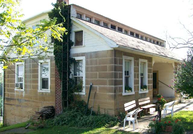
Photo: Bwsmith84, via Wikimedia Commons, CC BY 3.0 · Wikimedia Commons
Local history sources: monroe.ohgenweb.org · en.wikipedia.org · archive.org · commons.wikimedia.org · monroe.ohgenweb.org · en.wikipedia.org · archive.org
Historic places
1 place in Switzerland Township, Monroe County on the National Register of Historic Places. Press a pin or a name for its whole record.
-
Kindleberger, Frederick, Stone House and BarnBuilding · Clarington · listed 1980
- Address
- NW of Clarington on SR 25
- Where
- Clarington, Monroe County · ZIP 43915
- What it is
- Building
- Listed on the National Register
- 1980
- NRIS reference number
- 80003163
- Coordinates
- 39.83076, -80.90563
National Register file (NPS) ↗ Search Wikipedia ↗ Street map and directions ↗ On the Cracked Buckeye map
Source: National Park Service, National Register of Historic Places point file. The listing year is shown where NPS's certification date agrees with the listing's reference number. Listing recognizes significance; it does not restrict a private owner.
Water
Mostly private wells The water here
- Powhatan Point Public Water System45% of residentsGroundwater wells (3 wells)
- Clarington Village22% of residentsGroundwater wells (2 wells)
- Switzerland of Ohio Water18% of residentsBarnesville Reservoirs #1, #2 & Slope Creek Reservoir
- York Township Water Authority10% of residentsGroundwater wells (3 wells)
- Ohio and Lee Twp Water Authority5% of residentsGroundwater wells (2 wells)
- Switzer Water Association0% of residentsGroundwater wells (2 wells)
Hospitals, fire stations and more
Inside Switzerland Township, Monroe County's boundary: 2 poor-rated bridges, 58 shale and injection wells and 4 spill cases. Press a pin or a name for its whole record and its source.
Bridges rated poor (2)
-
Swi. Tr 947 over StreamPoor · built 1997
- Condition
- Poor: a deck, superstructure, substructure or culvert rated 4 or below on the 0 to 9 scale
- What it is
- Bridge
- Built
- 1997
- Length
- 9 ft
- Owner
- County
- Vehicles a day
- 96
- Coordinates
- 39.83436, -80.83807
National Bridge Inventory (source) ↗ Street map and directions ↗
-
Swi. Twp. 84 over Cats RunPoor · built 2005
- Condition
- Poor: a deck, superstructure, substructure or culvert rated 4 or below on the 0 to 9 scale
- What it is
- Bridge
- Built
- 2005
- Length
- 13 ft
- Owner
- County
- Vehicles a day
- 20
- Coordinates
- 39.85227, -80.89377
National Bridge Inventory (source) ↗ Street map and directions ↗
Source: FHWA National Bridge Inventory 2025. "Poor" means one major part rated 4 or below on the 0 to 9 scale; it calls for repair, not closing, unless the state posts or closes the bridge.
Shale and injection wells (58)
-
Baumberger Larry E & Bobby Switz18BhsuUtica shale well
- What it is
- Utica shale well
- Drilled sideways
- Yes
- Operator
- Cnx Gas Company Llc
- County
- Monroe County
- API well number
- 34111247630000
- Coordinates
- 39.84836, -80.89424
ODNR oil and gas wells (source) ↗ Street map and directions ↗
The point is the surface well head (the pad); a horizontal well runs a mile or more underground from it.
-
Baumberger Larry E & Bobby Switz18DhsuUtica shale well
- What it is
- Utica shale well
- Drilled sideways
- Yes
- Operator
- Cnx Gas Company Llc
- County
- Monroe County
- API well number
- 34111247640000
- Coordinates
- 39.84831, -80.89428
ODNR oil and gas wells (source) ↗ Street map and directions ↗
The point is the surface well head (the pad); a horizontal well runs a mile or more underground from it.
-
Baumberger Larry E & Bobby Switz18FhsuUtica shale well
- What it is
- Utica shale well
- Drilled sideways
- Yes
- Operator
- Cnx Gas Company Llc
- County
- Monroe County
- API well number
- 34111247620000
- Coordinates
- 39.84827, -80.89432
ODNR oil and gas wells (source) ↗ Street map and directions ↗
The point is the surface well head (the pad); a horizontal well runs a mile or more underground from it.
-
Baumberger Larry E & Bobby Switz18JhsuUtica shale well
- What it is
- Utica shale well
- Drilled sideways
- Yes
- Operator
- Cnx Gas Company Llc
- County
- Monroe County
- API well number
- 34111248820000
- Coordinates
- 39.84822, -80.89350
ODNR oil and gas wells (source) ↗ Street map and directions ↗
The point is the surface well head (the pad); a horizontal well runs a mile or more underground from it.
-
Baumberger Larry E & Bobby Switz18KhsuUtica shale well
- What it is
- Utica shale well
- Drilled sideways
- Yes
- Operator
- Cnx Gas Company Llc
- County
- Monroe County
- API well number
- 34111248810000
- Coordinates
- 39.84820, -80.89343
ODNR oil and gas wells (source) ↗ Street map and directions ↗
The point is the surface well head (the pad); a horizontal well runs a mile or more underground from it.
-
Brewster Switz6AhsmMarcellus shale well
- What it is
- Marcellus shale well
- Drilled sideways
- Yes
- Operator
- Cnx Gas Company Llc
- County
- Monroe County
- API well number
- 34111244500100
- Coordinates
- 39.83145, -80.91377
ODNR oil and gas wells (source) ↗ Street map and directions ↗
The point is the surface well head (the pad); a horizontal well runs a mile or more underground from it.
-
Brewster Switz6DhsuUtica shale well
- What it is
- Utica shale well
- Drilled sideways
- Yes
- Operator
- Cnx Gas Company Llc
- County
- Monroe County
- API well number
- 34111245050000
- Coordinates
- 39.83136, -80.91384
ODNR oil and gas wells (source) ↗ Street map and directions ↗
The point is the surface well head (the pad); a horizontal well runs a mile or more underground from it.
-
Brewster Switz6FhsuUtica shale well
- What it is
- Utica shale well
- Drilled sideways
- Yes
- Operator
- Cnx Gas Company Llc
- County
- Monroe County
- API well number
- 34111245030000
- Coordinates
- 39.83126, -80.91390
ODNR oil and gas wells (source) ↗ Street map and directions ↗
The point is the surface well head (the pad); a horizontal well runs a mile or more underground from it.
-
Brewster Switz6HhsuUtica shale well
- What it is
- Utica shale well
- Drilled sideways
- Yes
- Operator
- Cnx Gas Company Llc
- County
- Monroe County
- API well number
- 34111245040000
- Coordinates
- 39.83131, -80.91387
ODNR oil and gas wells (source) ↗ Street map and directions ↗
The point is the surface well head (the pad); a horizontal well runs a mile or more underground from it.
-
Brewster Switz6HsuUtica shale well
- What it is
- Utica shale well
- Drilled sideways
- Yes
- Operator
- Cnx Gas Company Llc
- County
- Monroe County
- API well number
- 34111244510100
- Coordinates
- 39.83140, -80.91381
ODNR oil and gas wells (source) ↗ Street map and directions ↗
The point is the surface well head (the pad); a horizontal well runs a mile or more underground from it.
-
Consol Mining Company Llc Switz27FhsuUtica shale well
- What it is
- Utica shale well
- Drilled sideways
- Yes
- Operator
- Cnx Gas Company Llc
- County
- Monroe County
- API well number
- 34111249050000
- Coordinates
- 39.80329, -80.85656
ODNR oil and gas wells (source) ↗ Street map and directions ↗
The point is the surface well head (the pad); a horizontal well runs a mile or more underground from it.
-
Consol Mining Company Llc Switz27GhsuUtica shale well
- What it is
- Utica shale well
- Drilled sideways
- Yes
- Operator
- Cnx Gas Company Llc
- County
- Monroe County
- API well number
- 34111249040000
- Coordinates
- 39.80334, -80.85654
ODNR oil and gas wells (source) ↗ Street map and directions ↗
The point is the surface well head (the pad); a horizontal well runs a mile or more underground from it.
-
Consol Mining Company Llc Switz27HhsuUtica shale well
- What it is
- Utica shale well
- Drilled sideways
- Yes
- Operator
- Cnx Gas Company Llc
- County
- Monroe County
- API well number
- 34111249010000
- Coordinates
- 39.80327, -80.85649
ODNR oil and gas wells (source) ↗ Street map and directions ↗
The point is the surface well head (the pad); a horizontal well runs a mile or more underground from it.
-
Consol Mining Company Llc Switz27JhsuUtica shale well
- What it is
- Utica shale well
- Drilled sideways
- Yes
- Operator
- Cnx Gas Company Llc
- County
- Monroe County
- API well number
- 34111249020000
- Coordinates
- 39.80332, -80.85647
ODNR oil and gas wells (source) ↗ Street map and directions ↗
The point is the surface well head (the pad); a horizontal well runs a mile or more underground from it.
-
Consol Mining Company Llc Switz27KhsuUtica shale well
- What it is
- Utica shale well
- Drilled sideways
- Yes
- Operator
- Cnx Gas Company Llc
- County
- Monroe County
- API well number
- 34111249030000
- Coordinates
- 39.80338, -80.85645
ODNR oil and gas wells (source) ↗ Street map and directions ↗
The point is the surface well head (the pad); a horizontal well runs a mile or more underground from it.
-
Craig Miller A 2HUtica shale well
- What it is
- Utica shale well
- Drilled sideways
- Yes
- Operator
- Expand Operating Llc
- County
- Monroe County
- API well number
- 34111248530000
- Coordinates
- 39.79810, -80.96296
ODNR oil and gas wells (source) ↗ Street map and directions ↗
The point is the surface well head (the pad); a horizontal well runs a mile or more underground from it.
-
Craig Miller A 4HUtica shale well
- What it is
- Utica shale well
- Drilled sideways
- Yes
- Operator
- Expand Operating Llc
- County
- Monroe County
- API well number
- 34111248560000
- Coordinates
- 39.79815, -80.96291
ODNR oil and gas wells (source) ↗ Street map and directions ↗
The point is the surface well head (the pad); a horizontal well runs a mile or more underground from it.
-
Craig Miller B 6HUtica shale well
- What it is
- Utica shale well
- Drilled sideways
- Yes
- Operator
- Expand Operating Llc
- County
- Monroe County
- API well number
- 34111248540000
- Coordinates
- 39.79820, -80.96286
ODNR oil and gas wells (source) ↗ Street map and directions ↗
The point is the surface well head (the pad); a horizontal well runs a mile or more underground from it.
-
Dietrich A 2HUtica shale well
- What it is
- Utica shale well
- Drilled sideways
- Yes
- Operator
- Expand Operating Llc
- County
- Monroe County
- API well number
- 34111245730000
- Coordinates
- 39.80911, -80.91336
ODNR oil and gas wells (source) ↗ Street map and directions ↗
The point is the surface well head (the pad); a horizontal well runs a mile or more underground from it.
-
Dietrich A 4HUtica shale well
- What it is
- Utica shale well
- Drilled sideways
- Yes
- Operator
- Expand Operating Llc
- County
- Monroe County
- API well number
- 34111245720000
- Coordinates
- 39.80917, -80.91337
ODNR oil and gas wells (source) ↗ Street map and directions ↗
The point is the surface well head (the pad); a horizontal well runs a mile or more underground from it.
-
Dietrich A 6HUtica shale well
- What it is
- Utica shale well
- Drilled sideways
- Yes
- Operator
- Expand Operating Llc
- County
- Monroe County
- API well number
- 34111245710000
- Coordinates
- 39.80922, -80.91337
ODNR oil and gas wells (source) ↗ Street map and directions ↗
The point is the surface well head (the pad); a horizontal well runs a mile or more underground from it.
-
Frances I Kinzey Et Ux Switz28BhsuUtica shale well
- What it is
- Utica shale well
- Drilled sideways
- Yes
- Operator
- Cnx Gas Company Llc
- County
- Monroe County
- API well number
- 34111246740000
- Coordinates
- 39.82332, -80.94219
ODNR oil and gas wells (source) ↗ Street map and directions ↗
The point is the surface well head (the pad); a horizontal well runs a mile or more underground from it.
-
Frances I Kinzey Et Ux Switz28DhsuUtica shale well
- What it is
- Utica shale well
- Drilled sideways
- Yes
- Operator
- Cnx Gas Company Llc
- County
- Monroe County
- API well number
- 34111246750000
- Coordinates
- 39.82328, -80.94224
ODNR oil and gas wells (source) ↗ Street map and directions ↗
The point is the surface well head (the pad); a horizontal well runs a mile or more underground from it.
-
Frances I Kinzey Et Ux Switz28FhsuUtica shale well
- What it is
- Utica shale well
- Drilled sideways
- Yes
- Operator
- Cnx Gas Company Llc
- County
- Monroe County
- API well number
- 34111246720000
- Coordinates
- 39.82331, -80.94229
ODNR oil and gas wells (source) ↗ Street map and directions ↗
The point is the surface well head (the pad); a horizontal well runs a mile or more underground from it.
-
Frances I Kinzey Et Ux Switz28HhsuUtica shale well
- What it is
- Utica shale well
- Drilled sideways
- Yes
- Operator
- Cnx Gas Company Llc
- County
- Monroe County
- API well number
- 34111246730000
- Coordinates
- 39.82335, -80.94225
ODNR oil and gas wells (source) ↗ Street map and directions ↗
The point is the surface well head (the pad); a horizontal well runs a mile or more underground from it.
-
Francis & April Kinzy Switz11JhsuUtica shale well
- What it is
- Utica shale well
- Drilled sideways
- Yes
- Operator
- Cnx Gas Company Llc
- County
- Monroe County
- API well number
- 34111246860000
- Coordinates
- 39.82458, -80.94477
ODNR oil and gas wells (source) ↗ Street map and directions ↗
The point is the surface well head (the pad); a horizontal well runs a mile or more underground from it.
-
Francis & April Kinzy Switz11LhsuUtica shale well
- What it is
- Utica shale well
- Drilled sideways
- Yes
- Operator
- Cnx Gas Company Llc
- County
- Monroe County
- API well number
- 34111246870000
- Coordinates
- 39.82460, -80.94483
ODNR oil and gas wells (source) ↗ Street map and directions ↗
The point is the surface well head (the pad); a horizontal well runs a mile or more underground from it.
-
Francis & April Kinzy Switz11NhsuUtica shale well
- What it is
- Utica shale well
- Drilled sideways
- Yes
- Operator
- Cnx Gas Company Llc
- County
- Monroe County
- API well number
- 34111246850000
- Coordinates
- 39.82463, -80.94490
ODNR oil and gas wells (source) ↗ Street map and directions ↗
The point is the surface well head (the pad); a horizontal well runs a mile or more underground from it.
-
Francis & April Kinzy Switz11PhsuUtica shale well
- What it is
- Utica shale well
- Drilled sideways
- Yes
- Operator
- Cnx Gas Company Llc
- County
- Monroe County
- API well number
- 34111246840000
- Coordinates
- 39.82466, -80.94496
ODNR oil and gas wells (source) ↗ Street map and directions ↗
The point is the surface well head (the pad); a horizontal well runs a mile or more underground from it.
-
Fuchs A 2HUtica shale well
- What it is
- Utica shale well
- Drilled sideways
- Yes
- Operator
- Expand Operating Llc
- County
- Monroe County
- API well number
- 34111245700100
- Coordinates
- 39.80900, -80.91335
ODNR oil and gas wells (source) ↗ Street map and directions ↗
The point is the surface well head (the pad); a horizontal well runs a mile or more underground from it.
-
Fuchs A 4HUtica shale well
- What it is
- Utica shale well
- Drilled sideways
- Yes
- Operator
- Expand Operating Llc
- County
- Monroe County
- API well number
- 34111245740000
- Coordinates
- 39.80906, -80.91336
ODNR oil and gas wells (source) ↗ Street map and directions ↗
The point is the surface well head (the pad); a horizontal well runs a mile or more underground from it.
-
Fuchs E-M Mnr 12HmMarcellus shale well
- What it is
- Marcellus shale well
- Drilled sideways
- Yes
- Operator
- Expand Operating Llc
- County
- Monroe County
- API well number
- 34111250070000
- Coordinates
- 39.80818, -80.91467
ODNR oil and gas wells (source) ↗ Street map and directions ↗
The point is the surface well head (the pad); a horizontal well runs a mile or more underground from it.
-
Fuchs E-M Mnr 14HmMarcellus shale well · Drilling
- What it is
- Marcellus shale well
- Drilled sideways
- Yes
- Status (ODNR)
- Drilling
- Operator
- Swn Production Company, Llc
- County
- Monroe County
- API well number
- 34111250060000
- Coordinates
- 39.80821, -80.91462
ODNR oil and gas wells (source) ↗ Street map and directions ↗
The point is the surface well head (the pad); a horizontal well runs a mile or more underground from it.
-
Fuchs G-M Mnr 16HmMarcellus shale well · Drilling
- What it is
- Marcellus shale well
- Drilled sideways
- Yes
- Status (ODNR)
- Drilling
- Operator
- Swn Production Company, Llc
- County
- Monroe County
- API well number
- 34111250080000
- Coordinates
- 39.80825, -80.91457
ODNR oil and gas wells (source) ↗ Street map and directions ↗
The point is the surface well head (the pad); a horizontal well runs a mile or more underground from it.
-
Ilona Baber Et Al Switz16BhsuUtica shale well
- What it is
- Utica shale well
- Drilled sideways
- Yes
- Operator
- Cnx Gas Company Llc
- County
- Monroe County
- API well number
- 34111245680000
- Coordinates
- 39.82557, -80.92418
ODNR oil and gas wells (source) ↗ Street map and directions ↗
The point is the surface well head (the pad); a horizontal well runs a mile or more underground from it.
-
Ilona Baber Et Al Switz16DhsuUtica shale well
- What it is
- Utica shale well
- Drilled sideways
- Yes
- Operator
- Cnx Gas Company Llc
- County
- Monroe County
- API well number
- 34111245660000
- Coordinates
- 39.82561, -80.92413
ODNR oil and gas wells (source) ↗ Street map and directions ↗
The point is the surface well head (the pad); a horizontal well runs a mile or more underground from it.
-
Ilona Baber Et Al Switz16FhsuUtica shale well
- What it is
- Utica shale well
- Drilled sideways
- Yes
- Operator
- Cnx Gas Company Llc
- County
- Monroe County
- API well number
- 34111245670000
- Coordinates
- 39.82553, -80.92423
ODNR oil and gas wells (source) ↗ Street map and directions ↗
The point is the surface well head (the pad); a horizontal well runs a mile or more underground from it.
-
Ilona Baber Et Al Switz16HhsuUtica shale well
- What it is
- Utica shale well
- Drilled sideways
- Yes
- Operator
- Cnx Gas Company Llc
- County
- Monroe County
- API well number
- 34111245690000
- Coordinates
- 39.82549, -80.92428
ODNR oil and gas wells (source) ↗ Street map and directions ↗
The point is the surface well head (the pad); a horizontal well runs a mile or more underground from it.
-
Ilona Baber Et Al Switz16JhsuUtica shale well
- What it is
- Utica shale well
- Drilled sideways
- Yes
- Operator
- Cnx Gas Company Llc
- County
- Monroe County
- API well number
- 34111245650000
- Coordinates
- 39.82545, -80.92433
ODNR oil and gas wells (source) ↗ Street map and directions ↗
The point is the surface well head (the pad); a horizontal well runs a mile or more underground from it.
-
Monroe North Unit 1HMarcellus shale well
- What it is
- Marcellus shale well
- Drilled sideways
- Yes
- Operator
- Ascent Resources Utica Llc
- County
- Monroe County
- API well number
- 34111243660000
- Coordinates
- 39.82273, -80.85041
ODNR oil and gas wells (source) ↗ Street map and directions ↗
The point is the surface well head (the pad); a horizontal well runs a mile or more underground from it.
-
Monroe North Unit 2HUtica shale well
- What it is
- Utica shale well
- Drilled sideways
- Yes
- Operator
- Ascent Resources Utica Llc
- County
- Monroe County
- API well number
- 34111243650100
- Coordinates
- 39.82275, -80.85038
ODNR oil and gas wells (source) ↗ Street map and directions ↗
The point is the surface well head (the pad); a horizontal well runs a mile or more underground from it.
-
Monroe North Unit C 2HUtica shale well
- What it is
- Utica shale well
- Drilled sideways
- Yes
- Operator
- Ascent Resources Utica Llc
- County
- Monroe County
- API well number
- 34111245640000
- Coordinates
- 39.82271, -80.85046
ODNR oil and gas wells (source) ↗ Street map and directions ↗
The point is the surface well head (the pad); a horizontal well runs a mile or more underground from it.
-
Pittman 2HUtica shale well
- What it is
- Utica shale well
- Drilled sideways
- Yes
- Operator
- Expand Operating Llc
- County
- Monroe County
- API well number
- 34111248550000
- Coordinates
- 39.79825, -80.96281
ODNR oil and gas wells (source) ↗ Street map and directions ↗
The point is the surface well head (the pad); a horizontal well runs a mile or more underground from it.
-
Quarto Miining Company Switz27BhsuUtica shale well
- What it is
- Utica shale well
- Drilled sideways
- Yes
- Operator
- Cnx Gas Company Llc
- County
- Monroe County
- API well number
- 34111248040000
- Coordinates
- 39.80392, -80.85675
ODNR oil and gas wells (source) ↗ Street map and directions ↗
The point is the surface well head (the pad); a horizontal well runs a mile or more underground from it.
-
Quarto Mining Company Switz27AhsuUtica shale well
- What it is
- Utica shale well
- Drilled sideways
- Yes
- Operator
- Cnx Gas Company Llc
- County
- Monroe County
- API well number
- 34111248070000
- Coordinates
- 39.80390, -80.85669
ODNR oil and gas wells (source) ↗ Street map and directions ↗
The point is the surface well head (the pad); a horizontal well runs a mile or more underground from it.
-
Quarto Mining Company Switz27ChsuUtica shale well
- What it is
- Utica shale well
- Drilled sideways
- Yes
- Operator
- Cnx Gas Company Llc
- County
- Monroe County
- API well number
- 34111248060000
- Coordinates
- 39.80397, -80.85673
ODNR oil and gas wells (source) ↗ Street map and directions ↗
The point is the surface well head (the pad); a horizontal well runs a mile or more underground from it.
-
Quarto Minining Company Switz27DhsuUtica shale well
- What it is
- Utica shale well
- Drilled sideways
- Yes
- Operator
- Cnx Gas Company Llc
- County
- Monroe County
- API well number
- 34111248050000
- Coordinates
- 39.80395, -80.85666
ODNR oil and gas wells (source) ↗ Street map and directions ↗
The point is the surface well head (the pad); a horizontal well runs a mile or more underground from it.
-
Richard E Lehman Switz9BhsuUtica shale well
- What it is
- Utica shale well
- Drilled sideways
- Yes
- Operator
- Cnx Gas Company Llc
- County
- Monroe County
- API well number
- 34111248330000
- Coordinates
- 39.84683, -80.84371
ODNR oil and gas wells (source) ↗ Street map and directions ↗
The point is the surface well head (the pad); a horizontal well runs a mile or more underground from it.
-
Richard E Lehman Switz9DhsuUtica shale well
- What it is
- Utica shale well
- Drilled sideways
- Yes
- Operator
- Cnx Gas Company Llc
- County
- Monroe County
- API well number
- 34111248340000
- Coordinates
- 39.84685, -80.84365
ODNR oil and gas wells (source) ↗ Street map and directions ↗
The point is the surface well head (the pad); a horizontal well runs a mile or more underground from it.
-
Richard E Lehman Switz9FhsuUtica shale well
- What it is
- Utica shale well
- Drilled sideways
- Yes
- Operator
- Cnx Gas Company Llc
- County
- Monroe County
- API well number
- 34111248350000
- Coordinates
- 39.84687, -80.84358
ODNR oil and gas wells (source) ↗ Street map and directions ↗
The point is the surface well head (the pad); a horizontal well runs a mile or more underground from it.
-
Richard E Lehman Switz9HhsuUtica shale well
- What it is
- Utica shale well
- Drilled sideways
- Yes
- Operator
- Cnx Gas Company Llc
- County
- Monroe County
- API well number
- 34111248360000
- Coordinates
- 39.84692, -80.84360
ODNR oil and gas wells (source) ↗ Street map and directions ↗
The point is the surface well head (the pad); a horizontal well runs a mile or more underground from it.
-
Roberts Victor L & Linda G Swit27BhsuUtica shale well
- What it is
- Utica shale well
- Drilled sideways
- Yes
- Operator
- Cnx Gas Company Llc
- County
- Monroe County
- API well number
- 34111247460000
- Coordinates
- 39.84152, -80.91626
ODNR oil and gas wells (source) ↗ Street map and directions ↗
The point is the surface well head (the pad); a horizontal well runs a mile or more underground from it.
-
Roberts Victor L & Linda G Swit27DhsuUtica shale well
- What it is
- Utica shale well
- Drilled sideways
- Yes
- Operator
- Cnx Gas Company Llc
- County
- Monroe County
- API well number
- 34111247450000
- Coordinates
- 39.84157, -80.91623
ODNR oil and gas wells (source) ↗ Street map and directions ↗
The point is the surface well head (the pad); a horizontal well runs a mile or more underground from it.
-
Roberts Victor L & Linda G Swit27FhsuUtica shale well
- What it is
- Utica shale well
- Drilled sideways
- Yes
- Operator
- Cnx Gas Company Llc
- County
- Monroe County
- API well number
- 34111247470000
- Coordinates
- 39.84155, -80.91616
ODNR oil and gas wells (source) ↗ Street map and directions ↗
The point is the surface well head (the pad); a horizontal well runs a mile or more underground from it.
-
Switzer Woods Switz5BhsuUtica shale well
- What it is
- Utica shale well
- Drilled sideways
- Yes
- Operator
- Cnx Gas Company Llc
- County
- Monroe County
- API well number
- 34111245860000
- Coordinates
- 39.83894, -80.93765
ODNR oil and gas wells (source) ↗ Street map and directions ↗
The point is the surface well head (the pad); a horizontal well runs a mile or more underground from it.
-
Switzer Woods Switz5DhsuUtica shale well
- What it is
- Utica shale well
- Drilled sideways
- Yes
- Operator
- Cnx Gas Company Llc
- County
- Monroe County
- API well number
- 34111245870000
- Coordinates
- 39.83890, -80.93760
ODNR oil and gas wells (source) ↗ Street map and directions ↗
The point is the surface well head (the pad); a horizontal well runs a mile or more underground from it.
-
Switzer Woods Switz5HhsuUtica shale well
- What it is
- Utica shale well
- Drilled sideways
- Yes
- Operator
- Cnx Gas Company Llc
- County
- Monroe County
- API well number
- 34111246030000
- Coordinates
- 39.83891, -80.93770
ODNR oil and gas wells (source) ↗ Street map and directions ↗
The point is the surface well head (the pad); a horizontal well runs a mile or more underground from it.
-
Switzer Woods Switz5JhsuUtica shale well
- What it is
- Utica shale well
- Drilled sideways
- Yes
- Operator
- Cnx Gas Company Llc
- County
- Monroe County
- API well number
- 34111246040000
- Coordinates
- 39.83886, -80.93765
ODNR oil and gas wells (source) ↗ Street map and directions ↗
The point is the surface well head (the pad); a horizontal well runs a mile or more underground from it.
Source: ODNR Division of Oil and Gas Resources well inventory (September 2026): drilled Utica, Marcellus and horizontal wells and Class II injection wells not plugged. Older vertical wells are on the full map.
Spills reported since 2021 (4)
-
Brine Oil And Gas Related2023-07-05 · Switzerland Twp
- Reported
- 2023-07-05
- What spilled
- Brine Oil And Gas Related
- Where
- Switzerland Twp, Monroe County
- Ohio EPA district office
- SEDO
- Ohio EPA case number
- 2307EPA0001101
Ohio EPA spill reports (source) ↗ Street map and directions ↗
-
Sediment / Sedimentation Reached water2022-03-07 · Null
- Reported
- 2022-03-07
- What spilled
- Sediment / Sedimentation
- Reached a waterway
- 99 - Unnamed
- Where
- Null, Monroe County
- Ohio EPA district office
- SEDO
- Ohio EPA case number
- 2203EPA0000288
Ohio EPA spill reports (source) ↗ Street map and directions ↗
-
Sediment / Sedimentation2022-03-07 · Null
- Reported
- 2022-03-07
- What spilled
- Sediment / Sedimentation
- Where
- Null, Monroe County
- Ohio EPA district office
- SEDO
- Ohio EPA case number
- 2203EPA0000287
Ohio EPA spill reports (source) ↗ Street map and directions ↗
-
Sediment / Sedimentation Reached water2022-03-07 · Null
- Reported
- 2022-03-07
- What spilled
- Sediment / Sedimentation
- Reached a waterway
- 99 - Unnamed
- Where
- Null, Monroe County
- Ohio EPA district office
- SEDO
- Ohio EPA case number
- 2203EPA0000286
Ohio EPA spill reports (source) ↗ Street map and directions ↗
Source: Ohio EPA emergency response spill reports, 2021 to September 2026, one point per case where Ohio EPA placed it. A report is what the caller or responder recorded; amounts are often blank or estimated.
Its ZIP codes
Each ZIP code that touches Switzerland Township, Monroe County, with the share of its residents who live here and the same headline figures as the ZIP page.
| ZIP | Share | Water | Radon | Home value | Schools | Flood |
|---|---|---|---|---|---|---|
| 43915 Salem Township and Clarington | 15% | Mostly private wells | 3.8 pCi/L average radon | Median year built 1965 | Switzerland of Ohio Local · 3 stars overall | 5.9% of residents in the 1% floodplain |
| 43716 Sunsbury Township and Beallsville | 8% | Mostly private wells | 9.5 pCi/L average radon | Median year built 1974 | Switzerland of Ohio Local · 3 stars overall | 0.3% of residents in the 1% floodplain |
| 43942 Powhatan Point | 5% | Two village production wells on Witten Ave plus a standby well, blended and treated at one village plant before distribution | 6.8 pCi/L average radon | Median year built 1956 | Switzerland of Ohio Local · 3 stars overall | 28% of residents in the 1% floodplain |
Local government
Who holds office in Switzerland Township, Monroe County, how its elections and ballot issues came out, and the state auditor's record.
Elections for office
| Date | Office | Candidates and votes |
|---|---|---|
| 2021-11-02 | Township Trustee | James Leonard Lehman 64, 52.89%; Thomas Taylor, Jr. 57, 47.11% |
| 2019-11-05 | Township Trustee | Russell Goddard 64, 53.33%; Trey Taylor 56, 46.67% |
| 2019-11-05 | Township Fiscal Officer | Christine K. Crowel! 98, 100.0% |
Winners in bold. Results from the county board of elections' official canvass unless marked.
Auditor of State record
- No fiscal caution, watch or emergency on the Auditor of State's lists.
- Agreed Upon Procedures, 2023 to 2024, released 2025-07-31
The county
Monroe County: 10 ZIP codes, 27 cities, villages and townships, 13,100 people.
Nearby places
Quick answers
What county is Switzerland Township, Ohio in?
Switzerland Township, Monroe County is a township in Monroe County, Ohio, with 462 residents.
When was Switzerland Township, Ohio founded?
Switzerland Township, Monroe County was settled 1819 (Father Jacob Tisher's German-Swiss immigrant party); incorporated 1827-01-01 (township organized). Source
How did Switzerland Township, Ohio get its name?
The township's name reflects the Swiss and German farming families who settled it, whose dairying and cheese-making echoed Switzerland's own agricultural tradition; no source consulted gives a more specific naming account. Source
What ZIP code is Switzerland Township, Ohio?
Switzerland Township, Monroe County is served by ZIP codes 43915, 43716 and 43942; 43915 holds the largest share of its residents.
Where does Switzerland Township, Ohio get its water?
The main water source for Switzerland Township, Monroe County (Powhatan Point Public Water System): Mostly private wells.
Cite this page
Cite this page as:
Cracked Buckeye, "Switzerland Township, Monroe County", https://crackedbuckeye.com/place/switzerland-township-monroe-county/, built 2026-10-31, accessed [date].
How to cite · Report a correction · Built 2026-10-31
