Local events in Powhatan Point
7 events in the next 90 days from 2 public calendars. All local events in Powhatan Point
Checked October 20; the events page is refreshed daily.
How Powhatan Point began
Powhatan Point stands on the Ohio River at the mouth of Captina Creek; Point describes the site and Powhatan likely commemorates the Powhatan confederacy of Virginia rather than any local presence. A grandson of the pioneer Archibald Woods built the first store about 1819 and a log hotel, the Point House, followed in 1825. A post office opened in 1828, the village was surveyed in 1849 (the 1903 county history names a Dr. Dellaas), and it was incorporated in 1890. A plaque marks a night George Washington reportedly camped at the mouth of Captina Creek. Coal powered the economy and the village peaked at 2,329 in 1930, standing at 1,461 in 2020.
Platted 1849, incorporated 1890, by surveyed by Dr. Dellaas (as printed) in 1849 per the 1903 county history.
Where the name comes from
'Point' describes the village's position at the confluence of Captina Creek and the Ohio River; 'Powhatan' most likely commemorates the Powhatan Native American confederacy of Virginia, a name choice not tied to any documented local Powhatan presence in this part of Ohio.
Before the town
No Native village, camp, or trail on the exact site of Powhatan Point is documented in the sources consulted, and the village's name is commemorative rather than evidence of local history: the Powhatan confederacy it likely references was based in coastal Virginia, far outside the upper Ohio Valley, and no source found places that nation, or any specific named nation, at this exact confluence. The broader stretch of the Ohio River here, at the mouth of Captina Creek, does carry documented eighteenth-century history: George Washington reportedly camped a night there while surveying the Ohio Valley, and the creek's mouth was the site of the April 1774 killing of Native men by Michael Cresap's party, one of the flashpoint incidents of Lord Dunmore's War. That eighteenth-century violence involved Mingo and other Ohio Valley Native people, not the Powhatan.
Timeline
- — George Washington reportedly camps a night at the mouth of Captina Creek, at the future site of Powhatan Point, while exploring the Ohio Valley.
- — A grandson of Archibald Woods, an early settler, built the first building at the point, used as a store, thirty years before the survey.
- — The first hotel, a log house known as the Point House, was built.
- — A post office called Powhatan Point begins operating.
- — A small frame school was built near Powhatan Point.
- — The village is formally platted along the Ohio River at the confluence with Captina Creek, laid out by Franklin Knox.
- — The Powhatan Presbyterian Church was organized, and during the Civil War a Methodist society began and later built a brick church with $1,800 raised by two women and Joseph Green.
- — The census counted 225 residents.
- — The village was incorporated; the 1903 history said it was the leading village of the township, with about 600 residents in 1902.
- — The village's population is recorded at 470.
- — The Powhatan Mills, a brick flour mill built by the Boger Brothers, ran 100 barrels a day; a brick four-room school had about 150 pupils, and E. R. Potts owned and ran the ferries.
- — The village's population peaks at 2,329, a more than fourfold increase from 1900, likely driven by the area's coal industry.
- — The village's population, by then declining from its 1930 peak, is recorded at 2,181.
- — The census counted 1,461 residents, down from 2,329 in 1930.
Stories
A name from Virginia, a landscape from the Ohio Valley
Powhatan Point's name tells two different stories at once. 'Point' is plainly descriptive, marking the spot where Captina Creek meets the Ohio River, the same confluence where George Washington reportedly camped for a night while surveying the valley decades before any town existed there, and where, in April 1774, Michael Cresap's men killed Native people in an incident that helped ignite Lord Dunmore's War. 'Powhatan,' though, borrows the name of a Native confederacy that never lived anywhere near this stretch of the Ohio River; it was based hundreds of miles away on Virginia's coastal plain, familiar to nineteenth-century Ohioans mostly through history and legend rather than local memory. The pairing is typical of how many Ohio place names used Native words or names as decoration, honoring a distant and often romanticized history rather than recording the specific nations, Mingo, Lenape, Shawnee, and others, who had actually lived and traveled along this exact stretch of river.
The point on the Ohio
Powhatan Point began as a place where goods changed hands at the mouth of Captina Creek. About 1819 a grandson of the pioneer Archibald Woods put up the first building as a store, and in 1825 someone built a log tavern, the Point House, for travelers on the Ohio. Dr. Dellaas, as the 1903 county history prints the name, surveyed the town in 1849, and the Boger Brothers put up the first brick building, the Powhatan Flour Mills and Woolen Factory. Twenty years before 1903 the place was a shipping point for grain and produce with about 300 people. It was incorporated in 1890, and by 1902 had some 600 residents, a four-room brick school with about 150 pupils and ferries across to West Virginia that ran whenever the river allowed. The coal mines would later bring it to 2,329 people in 1930.
Photographs
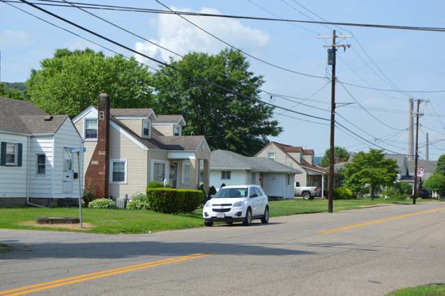
Photo: Nyttend, public domain · Wikimedia Commons
Local history sources: en.wikipedia.org · en.wikipedia.org · commons.wikimedia.org · archive.org
Water
Two village production wells on Witten Ave plus a standby well, blended and treated at one village plant before distribution The water here
- Powhatan Point Public Water System82% of residentsGroundwater wells (3 wells)
- York Township Water Authority18% of residentsGroundwater wells (3 wells)
Hospitals, fire stations and more
Inside Powhatan Point's boundary: 1 fire or EMS station, 1 library, 1 police station and 4 spill cases. Press a pin or a name for its whole record and its source.
Fire and EMS stations (1)
-
Powhatan Fire Department and Emergency SquadPowhatan Point
- Address
- 104 Mellott Street, Powhatan Point, OH 43942
- Coordinates
- 39.86209, -80.80310
USGS National Map structures (source) ↗ Street map and directions ↗
Source: USGS National Map structures (most Ohio records last updated 2019 to 2022), checked against the Columbus and Cleveland station lists. The department that answers a call is set by jurisdiction and mutual aid, not by distance.
Public libraries (1)
-
Powhatan Point BranchBranch · Powhatan Point
- Address
- 297 N Route 7, Powhatan Point, OH 43942
- What it is
- Branch
- Library system
- Belmont County District Library
- Open
- 1,872 hours a year, 52 weeks
- Building
- 2,600 sq ft
- System's visits, FY2024
- 74,932
- System's loans, FY2024
- 114,482
- People the system serves
- 33,295
- Phone
- (740) 795-4624
IMLS Public Libraries Survey (source) ↗ Street map and directions ↗
Source: IMLS Public Libraries Survey FY2024 (outlets and their systems). Any Ohio resident can get a free card at any Ohio public library.
Police stations (1)
-
Powhatan Point Police DepartmentPowhatan Point
- Address
- 104 Mellott Street, Powhatan Point, OH 43942
- Coordinates
- 39.86193, -80.80291
USGS National Map structures (source) ↗ Street map and directions ↗
Source: USGS National Map structures, police stations, corrected and completed by hand (September 2026). The department that answers a call is set by jurisdiction, not by distance.
Spills reported since 2021 (4)
-
Material Unknown2024-04-07 · Powhatan Point
- Reported
- 2024-04-07
- What spilled
- Material Unknown
- Where
- Powhatan Point, Belmont County
- Ohio EPA district office
- SEDO
- Ohio EPA case number
- 2404EPA0000554
Ohio EPA spill reports (source) ↗ Street map and directions ↗
-
Sheen Rainbow / Hydrocarbon Reached water2022-05-11 · Powhatan Point
- Reported
- 2022-05-11
- What spilled
- Sheen Rainbow / Hydrocarbon
- Reached a waterway
- 07 - Big Run
- Where
- Powhatan Point, Belmont County
- Ohio EPA district office
- SEDO
- Ohio EPA case number
- 2205EPA0000679
Ohio EPA spill reports (source) ↗ Street map and directions ↗
-
Oil Petroleum Not Otherwise Specified (Nos)2026-08-31 · Powhatan Point
- Reported
- 2026-08-31
- What spilled
- Oil Petroleum Not Otherwise Specified (Nos); Fuel Gasoline ( 25% Ethanol Not E85)
- Where
- Powhatan Point, Belmont County
- Ohio EPA district office
- SEDO
- Ohio EPA case number
- 2608EPA0001624
Ohio EPA spill reports (source) ↗ Street map and directions ↗
-
Bentonite / Drilling Mud2026-06-10 · Powhatan Point
- Reported
- 2026-06-10
- What spilled
- Bentonite / Drilling Mud
- Largest amount reported
- 15 gallons
- Where
- Powhatan Point, Belmont County
- Ohio EPA district office
- SEDO
- Ohio EPA case number
- 2606EPA0001029
Ohio EPA spill reports (source) ↗ Street map and directions ↗
Source: Ohio EPA emergency response spill reports, 2021 to September 2026, one point per case where Ohio EPA placed it. A report is what the caller or responder recorded; amounts are often blank or estimated.
Its ZIP codes
Each ZIP code that touches Powhatan Point, with the share of its residents who live here and the same headline figures as the ZIP page.
| ZIP | Share | Water | Radon | Home value | Schools | Flood |
|---|---|---|---|---|---|---|
| 43942 Powhatan Point | 59% | Two village production wells on Witten Ave plus a standby well, blended and treated at one village plant before distribution | 6.8 pCi/L average radon | Median year built 1956 | Switzerland of Ohio Local · 3 stars overall | 28% of residents in the 1% floodplain |
Local government
Who holds office in Powhatan Point, how its elections and ballot issues came out, and the state auditor's record.
Money issues on the ballot since 2015: 2 of 2 passed; of those asking for new or higher taxes, 1 of 1.
Ballot issues
| Date | Issue | For | Against | Result |
|---|---|---|---|---|
| 2021-11-02 | Issue: Powhatan Point Village Marihuana Ordinance | 86 | 123 | Failed (41.15% for), unofficial |
| 2020-11-03 | Issue: Powhatan Point Village Municipal Park Levy | 435 | 212 | Passed (67.23% for) |
| 2016-11-08 | Issue: Village of Powhatan Point - Replacement Fire | 324 | 326 | Failed (49.85% for) |
| 2015-11-03 | Issue: Village of Powhatan Point - Park District Additional Levy | 254 | 201 | Passed (55.82% for) |
Elections for office
| Date | Office | Candidates and votes |
|---|---|---|
| 2021-11-02 | Village Council (unofficial count) | Rob Caldwell 143, 39.72%; Michael A. Knight 90, 25.0%; John T. Mitchell 101, 28.06%; Write-In: Robert L. Putsock 16, 4.44% |
| 2021-11-02 | Mayor (unofficial count) | Write-In: Christopher Andrew Heslep 3, 5.66% |
| 2021-11-02 | Board of Public Affairs (unofficial count) | Philip J. Asturi 161, 100.0% |
| 2019-11-05 | Village Council | Joseph A. Asturi 129, 36.13%; H. Brady Dierkes 84, 23.53%; David L. Walters 144, 40.34% |
| 2017-11-07 | Village Council | Rob Caldwell 212, 36.49%; John T. Mitchell 190, 32.7%; Chuck Davis 127, 21.86%; Write-In: Michael Knight 25, 4.3% |
| 2017-11-07 | Mayor | Write-In: Jeffrey Clark Haught 73, 66.36% |
| 2017-11-07 | Board of Public Affairs | Philip J. Asturi 247, 100.0% |
| 2015-11-03 | Village Council | H. Brady Dierkes 272, 45.26%; David L. Walters 329, 54.74% |
| 2015-11-03 | Mayor | Mark McVey 386, 100.0% |
| 2015-11-03 | Clerk-Treasurer | Lisa K. Armann-Blue 330, 100.0% |
| 2015-11-03 | Board of Public Affairs | Benjamin A. Duvall 332, 57.04%; Frank R. Leopold 250, 42.96% |
Winners in bold. Results from the county board of elections' official canvass unless marked.
The county
Belmont County: 23 ZIP codes, 29 cities, villages and townships, 64,982 people.
Nearby places
Rain and snow
How much has actually fallen on Powhatan Point, day by day, from 1878 to now. Daily totals, not averages.
- rain, last 30 days
- 2.72 in
- 2026-09-30 to 2026-10-29
- rain so far in 2026
- 46.3 in
- 7.4 in above normal for the date
- snow so far in 2026
- 21.9 in
- a normal year brings 21.3 in
- a normal year
- 45.9 in
- average of 30 years, 1991-2020
| Month | Rain (in) | Snow (in) | Days counted |
|---|---|---|---|
| October 2026 | 2.73 | — | 29 |
| September 2026 | 4.52 | — | 30 |
| August 2026 | 7.56 | — | 31 |
| July 2026 | 4.57 | — | 31 |
| June 2026 | 5.26 | — | 30 |
| May 2026 | 5.68 | — | 31 |
| April 2026 | 5.11 | — | 30 |
| March 2026 | 7.09 | 5.2 | 31 |
| February 2026 | 1.51 | 3.0 | 28 |
| January 2026 | 2.29 | 13.7 | 31 |
| December 2025 | 2.32 | 11.4 | 31 |
| November 2025 | 2.38 | — | 30 |
| Wettest year | 2018 — 67.4 in |
|---|---|
| Driest year | 1930 — 24.7 in |
| Snowiest year | 1914 — 56.2 in |
| Wettest day on record | 18 September 2004 — 6.47 in |
| Heaviest snowfall in a day | 14 March 1993 — 18.56 in |
| Deepest snow on the ground | 20 January 1994 — 24.83 in |
Estimated, not measured. No rain gauge has ever stood inside Powhatan Point, so every figure here is worked out from the gauges around it - the nearest ones weighted most. Treat them as close estimates rather than readings.
51,991 days of records, 1878-02-01 to 2026-10-29. Source: NOAA NCEI GHCN-Daily, 3,240 gauges in and around Ohio. A day is "gauged" when a gauge standing inside the boundary reported it, and the value is the mean of those gauges. Otherwise it is interpolated by inverse distance from every gauge reporting within 50 miles. Nothing is carried forward, back-filled or smoothed. Against NOAA nClimDiv county monthly precipitation over 136,848 complete county-months (checked 2026-10-31): correlation 0.9515, median absolute difference 0.217 in a month. Built 2026-10-31 from the Cracked Buckeye precipitation archive. Snow is the softer number — snowfall is measured by hand with a ruler, no agency publishes a gridded county snowfall series, and blowing snow defeats every observer.
Environmental permits and filings
What Ohio EPA has on file for Powhatan Point: permits, inspections, violations, cleanups and the state loans behind sewer and water work. Every line links to the agency's own document.
- facilities and sites on file
- 8
- those placed on the map inside Powhatan Point
| Program | Facilities and sites |
|---|---|
| Brownfield | 2 |
| State sewer loans | 2 |
| State water loans | 2 |
| Air pollution | 1 |
| Public drinking water | 1 |
Source: Ohio EPA eDocument portal (edocpub.epa.ohio.gov), indexed 2026-10-14. Facilities are placed on the map from Ohio EPA's own map layers, EPA's Facility Registry, coordinates written in the filings, or a geocoded street address. A permit filed under a private person's name (most are household septic systems) is counted but never named, placed or linked; licenses for individual workers and open-burning notices are left out entirely.
Quick answers
What county is Powhatan Point, Ohio in?
Powhatan Point is a village in Belmont County, Ohio, with 1,342 residents.
When was Powhatan Point, Ohio founded?
Powhatan Point was laid out 1849; incorporated 1890. Founders on record: surveyed by Dr. Dellaas (as printed) in 1849 per the 1903 county history. Source
How did Powhatan Point, Ohio get its name?
'Point' describes the village's position at the confluence of Captina Creek and the Ohio River; 'Powhatan' most likely commemorates the Powhatan Native American confederacy of Virginia, a name choice not tied to any documented local Powhatan presence in this part of Ohio. Source
What ZIP code is Powhatan Point, Ohio?
Most of Powhatan Point is in ZIP code 43942.
Where does Powhatan Point, Ohio get its water?
The main water source for Powhatan Point (Powhatan Point Public Water System): Two village production wells on Witten Ave plus a standby well, blended and treated at one village plant before distribution.
Cite this page
Cite this page as:
Cracked Buckeye, "Powhatan Point, Belmont County", https://crackedbuckeye.com/place/powhatan-point/, built 2026-10-31, accessed [date].
How to cite · Report a correction · Built 2026-10-31
