Local events in York Township, Belmont County
Nothing is posted for York Township itself yet; here is what is on within 10 miles. All local events in York Township, Belmont County
Know a calendar we should watch? Send the link
Checked October 20; the events page is refreshed daily.
How York Township, Belmont County began
York Township sits in southeastern Belmont County along the Ohio River, facing Marshall County, West Virginia; the village of Powhatan Point occupies its southeastern corner along the river, and the township hall stands at Steinersville. Local historians in 1880 concluded, after examining the ground and reviewing earlier accounts, that the Native village George Washington recorded in his journal as 'Grape Vine Town' during his 1770 tour down the Ohio most likely stood on the farm settled by John Bryson, where arrowheads, pipes, and other relics were plowed up for decades and rock carvings, including a still-visible bear track, could once be seen nearby; a stone carved 'L.W., 1790,' found near the site of the 1785 Battle of Captina Creek, is locally attributed to the frontier hunter Lewis Wetzel. In February 2018 an XTO Energy natural-gas well in the township blew out and burned uncontrolled for 20 days, forcing about 30 homes to evacuate and releasing more than 50,000 tons of methane, an amount greater than the yearly oil-and-gas methane emissions of most European countries; the leak was detected from orbit by the European Space Agency's Sentinel-5P satellite before it was brought under control on the ground.
Where the name comes from
No documented explanation of the township's name was found; it is one of ten York Townships statewide in Ohio.
Before the town
York Township holds some of Belmont County's most specific documented Native history. Mounds occur in different places throughout the township, attributed by the 1880 county history to a 'race anterior to the Indian,' the mound-building culture. After what the source describes as diligent search and personal examination of the ground, local historians concluded that the Native village recorded by George Washington in his journal as 'Grape Vine Town,' visited by traders from 1764 to 1770 and noted by Washington himself during his fall 1770 tour down the Ohio River, most probably stood on the farm settled and entered by John Bryson, later owned by Isaac Ramsey; an unusual number of grape vines found on the tract when Bryson first settled, and ground in the bottom found tramped hard on first plowing, were read as the surest signs of a former wigwam site. Two Native skeletons were found under rocks in the vicinity, and Bryson's daughter, Mrs. I. J. Potts, recalled numbers of arrowheads, pipes, and other relics plowed up on the family farm, along with rock inscriptions of bird and animal tracks and footprints, most now weathered away, though a bear track carving was still visible in 1880 near the residence of the late Hon. Isaac Welsh. Near where Cove Run meets the site of the 1785 battle of Captina Creek, a stone bearing the carved initials 'L.W., 1790' was found in 1865 by I. J. Potts and Isaac Jones; the initials are locally read as those of Lewis Wetzel, the noted frontier hunter and scout, marking what is thought to have been one of his hiding places and favorite resorts.
- "Grape Vine Town" (village) — John Bryson farm (later Isaac Ramsey farm), Captina Creek valley, York Township, recorded by George Washington's journal, 1764-1770 (archive.org)
- Rock carvings and bear-track pictograph (other) — Captina Creek valley, on the Bryson/Ramsey farm and near the residence of the late Hon. Isaac Welsh, York Township, undated, pre-settlement (archive.org)
- "L.W., 1790" carved stone (traditionally Lewis Wetzel) (other) — near the mouth of Cove Run, near the site of the 1785 battle of Captina Creek, York Township, 1790 (archive.org)
Timeline
- — The Belmont County court, then held at Pultney, appoints John Dille, Ephraim Bates, and Michael Moore as the township's first supervisors, and Samuel Dille as constable; the first township election is ordered held at the house of James Smith in 1802.
- — George Gates settles and erects a grist mill on Cats Run, thought by some to be the first built in the township.
- — Township officers elected and serving this year include Township Clerk Edward Bryson, Trustees Uriah Martin, Abel Brown, and Edward Bryson, and Treasurer Joseph Martin.
- — A man named Simpler erects a small distillery on section 15, on Little Captina Creek, one of several small distilleries the township supported.
- — The first building in what becomes Powhatan Point is erected by a man named Woods and used by Mallery as a small store.
- — Judge Bryson is appointed postmaster of Captina post office, at Captina Mills five miles up Captina Creek from its mouth.
- — Judge Dillon builds a grist mill about five miles above Powhatan Point on the waters of Captina Creek, its headrace tunneled about three hundred feet through a hill.
- — Steinersville is laid out by John W. Steiner on September 28, along the Powhatan Point and Green Fording macadamized road.
- — Michael Dorsey is appointed postmaster at Captina; the 1880 county history calls him, still serving, 'the oldest postmaster in Ohio, and the third oldest in the United States.'
- — Powhatan Point village is surveyed in January by De Hass and laid out by Franklin W. Knox, grandson of pioneer Archibald Woods.
- — The village of Industry is laid out by Samuel P. Jones on July 7, on Captina Creek along the Powhatan Point and Green Fording road; John Ewers and Robert Donaldson erect its first buildings.
- — While digging a well in Powhatan, Lewis Boger, Sr.'s workman Philip Frankhauser strikes an underground 'air chamber' at about thirty feet depth, releasing gas (almost certainly natural gas) with enough force that work is halted for about a week before the opening is cemented over.
- — In February, an XTO Energy natural-gas well in York Township experiences an explosion and blowout; the resulting fire and uncontrolled release forces about 30 nearby homes to evacuate.
- — The blowout burns for 20 days before being controlled, releasing more than 50,000 tons of methane, more than the annual oil-and-gas methane emissions of most European nations; brine and produced water discharge into streams flowing toward the Ohio River, and the plume is detected from space by the Copernicus Sentinel-5P satellite's Tropospheric Monitoring Instrument.
Stories
A blowout seen from orbit
For twenty days in February 2018, an XTO Energy natural-gas well in York Township burned out of control, forcing roughly 30 households near the site to leave their homes while crews worked to bring it under control. By the time the well was finally capped, it had released more than 50,000 tons of methane into the atmosphere, a figure large enough that scientists later calculated it exceeded the entire annual oil-and-gas-sector methane emissions of most individual European countries, all from a single well in a single township. The scale of the release was confirmed in an unusual way: the plume was detected and measured from space, by the European Space Agency's Sentinel-5P satellite and its Tropospheric Monitoring Instrument, making the York Township blowout one of the first major U.S. methane leaks documented from orbit rather than only from ground measurements. Brine and produced water from the well also reached local streams that feed the Ohio River before the site was secured.
Grape Vine Town and Washington's journal
In the fall of 1770, George Washington, touring down the Ohio River, recorded in his journal passing a Native village he called 'Grape Vine Town,' a place, by other accounts, that had already been visited by traders for at least six years. A century later, local historians in York Township set out to find where it had stood, reviewing earlier writers' accounts and personally walking the ground before concluding it most likely sat on the farm John Bryson had settled, later owned by Isaac Ramsey. Their evidence was circumstantial but consistent: an unusual density of wild grapevines that had caught Bryson's attention when he first cleared the land, patches of bottom ground tramped unusually hard when first plowed, two human skeletons found under nearby rocks, and, scattered across the farm for two generations, arrowheads, pipes, and other relics that Bryson's own daughter remembered being turned up by the plow throughout her childhood. Rock carvings of animal tracks and footprints once marked the valley nearby, though most had weathered away or been quarried off by the time the county history was written; one bear-track carving, however, could still be seen in 1880 near the home of the late Hon. Isaac Welsh, one of the last physical traces of a village whose exact location might otherwise have been lost entirely.
Photographs
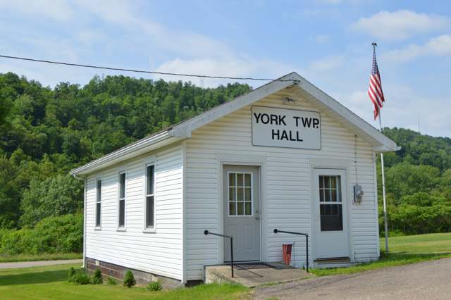
Photo: Nyttend, public domain · Wikimedia Commons
Local history sources: en.wikipedia.org · commons.wikimedia.org · archive.org
Water
Two village production wells on Witten Ave plus a standby well, blended and treated at one village plant before distribution The water here
- Powhatan Point Public Water System81% of residentsGroundwater wells (3 wells)
- York Township Water Authority19% of residentsGroundwater wells (3 wells)
- Shadyside Public Water System1% of residentsGroundwater wells (2 wells)
Hospitals, fire stations and more
Inside York Township, Belmont County's boundary: 1 public school, 69 shale and injection wells, 1 Superfund site and 1 spill case. Press a pin or a name for its whole record and its source.
Public schools (1)
-
Powhatan Elementary School2.5 of 5 stars · Powhatan Point
- Address
- 54685 Mount Victory Rd, Powhatan Point, OH 43942
- School district
- Switzerland of Ohio Local School District
- Kind (NCES)
- Regular School
- Students, 2023-24
- 194
- Teachers (full-time equivalent)
- 15.5
- Report card, 2025-26
- 2.5 of 5 stars
- Performance index
- 65.2%
- Ohio building IRN
- 030643
- NCES school ID
- 390486503334
NCES school record ↗ Ohio School Report Card ↗ Street map and directions ↗
Source: NCES EDGE public school locations 2024-25 and Common Core of Data 2023-24 (type, students, teachers); Ohio School Report Cards 2025-26 (Department of Education and Workforce), matched by name within the district.
Shale and injection wells (69)
-
Alpha 210488 1AUtica shale well
- What it is
- Utica shale well
- Drilled sideways
- Yes
- Operator
- Gulfport Appalachia Llc
- County
- Belmont County
- API well number
- 34013212660000
- Coordinates
- 39.88272, -80.86825
ODNR oil and gas wells (source) ↗ Street map and directions ↗
The point is the surface well head (the pad); a horizontal well runs a mile or more underground from it.
-
Alpha 210488 2BUtica shale well
- What it is
- Utica shale well
- Drilled sideways
- Yes
- Operator
- Gulfport Appalachia Llc
- County
- Belmont County
- API well number
- 34013212670000
- Coordinates
- 39.88274, -80.86820
ODNR oil and gas wells (source) ↗ Street map and directions ↗
The point is the surface well head (the pad); a horizontal well runs a mile or more underground from it.
-
Alpha 210488 3CUtica shale well
- What it is
- Utica shale well
- Drilled sideways
- Yes
- Operator
- Gulfport Appalachia Llc
- County
- Belmont County
- API well number
- 34013212680000
- Coordinates
- 39.88276, -80.86814
ODNR oil and gas wells (source) ↗ Street map and directions ↗
The point is the surface well head (the pad); a horizontal well runs a mile or more underground from it.
-
Big Dawg 1H-AUtica shale well
- What it is
- Utica shale well
- Drilled sideways
- Yes
- Operator
- Rice Drilling D Llc
- County
- Belmont County
- API well number
- 34013209750000
- Coordinates
- 39.86075, -80.87986
ODNR oil and gas wells (source) ↗ Street map and directions ↗
The point is the surface well head (the pad); a horizontal well runs a mile or more underground from it.
-
Big Dawg 3H-AUtica shale well
- What it is
- Utica shale well
- Drilled sideways
- Yes
- Operator
- Rice Drilling D Llc
- County
- Belmont County
- API well number
- 34013209740100
- Coordinates
- 39.86082, -80.87986
ODNR oil and gas wells (source) ↗ Street map and directions ↗
The point is the surface well head (the pad); a horizontal well runs a mile or more underground from it.
-
Big Dawg 5HUtica shale well
- What it is
- Utica shale well
- Drilled sideways
- Yes
- Operator
- Rice Drilling D Llc
- County
- Belmont County
- API well number
- 34013209460000
- Coordinates
- 39.86102, -80.87985
ODNR oil and gas wells (source) ↗ Street map and directions ↗
The point is the surface well head (the pad); a horizontal well runs a mile or more underground from it.
-
Big Dawg 7HUtica shale well
- What it is
- Utica shale well
- Drilled sideways
- Yes
- Operator
- Rice Drilling D Llc
- County
- Belmont County
- API well number
- 34013209480000
- Coordinates
- 39.86109, -80.87985
ODNR oil and gas wells (source) ↗ Street map and directions ↗
The point is the surface well head (the pad); a horizontal well runs a mile or more underground from it.
-
Charlie 210055 1AUtica shale well
- What it is
- Utica shale well
- Drilled sideways
- Yes
- Operator
- Gulfport Appalachia Llc
- County
- Belmont County
- API well number
- 34013209780000
- Coordinates
- 39.87844, -80.84245
ODNR oil and gas wells (source) ↗ Street map and directions ↗
The point is the surface well head (the pad); a horizontal well runs a mile or more underground from it.
-
Charlie 210055 2BUtica shale well
- What it is
- Utica shale well
- Drilled sideways
- Yes
- Operator
- Gulfport Appalachia Llc
- County
- Belmont County
- API well number
- 34013209770000
- Coordinates
- 39.87841, -80.84241
ODNR oil and gas wells (source) ↗ Street map and directions ↗
The point is the surface well head (the pad); a horizontal well runs a mile or more underground from it.
-
Charlie 210055 3CUtica shale well
- What it is
- Utica shale well
- Drilled sideways
- Yes
- Operator
- Gulfport Appalachia Llc
- County
- Belmont County
- API well number
- 34013209760000
- Coordinates
- 39.87839, -80.84237
ODNR oil and gas wells (source) ↗ Street map and directions ↗
The point is the surface well head (the pad); a horizontal well runs a mile or more underground from it.
-
Charlie 210468 7AUtica shale well
- What it is
- Utica shale well
- Drilled sideways
- Yes
- Operator
- Gulfport Appalachia Llc
- County
- Belmont County
- API well number
- 34013214510000
- Coordinates
- 39.87824, -80.84190
ODNR oil and gas wells (source) ↗ Street map and directions ↗
The point is the surface well head (the pad); a horizontal well runs a mile or more underground from it.
-
Charlie 210468 8BUtica shale well
- What it is
- Utica shale well
- Drilled sideways
- Yes
- Operator
- Gulfport Appalachia Llc
- County
- Belmont County
- API well number
- 34013214500000
- Coordinates
- 39.87828, -80.84188
ODNR oil and gas wells (source) ↗ Street map and directions ↗
The point is the surface well head (the pad); a horizontal well runs a mile or more underground from it.
-
Charlie 210469 10BUtica shale well
- What it is
- Utica shale well
- Drilled sideways
- Yes
- Operator
- Gulfport Appalachia Llc
- County
- Belmont County
- API well number
- 34013214480000
- Coordinates
- 39.87826, -80.84184
ODNR oil and gas wells (source) ↗ Street map and directions ↗
The point is the surface well head (the pad); a horizontal well runs a mile or more underground from it.
-
Charlie 210469 9AUtica shale well
- What it is
- Utica shale well
- Drilled sideways
- Yes
- Operator
- Gulfport Appalachia Llc
- County
- Belmont County
- API well number
- 34013214490000
- Coordinates
- 39.87821, -80.84185
ODNR oil and gas wells (source) ↗ Street map and directions ↗
The point is the surface well head (the pad); a horizontal well runs a mile or more underground from it.
-
Charlie 210472 4AUtica shale well
- What it is
- Utica shale well
- Drilled sideways
- Yes
- Operator
- Gulfport Appalachia Llc
- County
- Belmont County
- API well number
- 34013210130000
- Coordinates
- 39.87836, -80.84233
ODNR oil and gas wells (source) ↗ Street map and directions ↗
The point is the surface well head (the pad); a horizontal well runs a mile or more underground from it.
-
Charlie 210472 5BUtica shale well
- What it is
- Utica shale well
- Drilled sideways
- Yes
- Operator
- Gulfport Appalachia Llc
- County
- Belmont County
- API well number
- 34013210140000
- Coordinates
- 39.87833, -80.84229
ODNR oil and gas wells (source) ↗ Street map and directions ↗
The point is the surface well head (the pad); a horizontal well runs a mile or more underground from it.
-
Charlie 210472 6CUtica shale well
- What it is
- Utica shale well
- Drilled sideways
- Yes
- Operator
- Gulfport Appalachia Llc
- County
- Belmont County
- API well number
- 34013210150000
- Coordinates
- 39.87830, -80.84225
ODNR oil and gas wells (source) ↗ Street map and directions ↗
The point is the surface well head (the pad); a horizontal well runs a mile or more underground from it.
-
Hendershot 210471 1AUtica shale well
- What it is
- Utica shale well
- Drilled sideways
- Yes
- Operator
- Gulfport Appalachia Llc
- County
- Belmont County
- API well number
- 34013213240000
- Coordinates
- 39.88778, -80.81005
ODNR oil and gas wells (source) ↗ Street map and directions ↗
The point is the surface well head (the pad); a horizontal well runs a mile or more underground from it.
-
Hendershot 210471 2BUtica shale well
- What it is
- Utica shale well
- Drilled sideways
- Yes
- Operator
- Gulfport Appalachia Llc
- County
- Belmont County
- API well number
- 34013213270000
- Coordinates
- 39.88780, -80.81009
ODNR oil and gas wells (source) ↗ Street map and directions ↗
The point is the surface well head (the pad); a horizontal well runs a mile or more underground from it.
-
Hendershot 210474 4BUtica shale well
- What it is
- Utica shale well
- Drilled sideways
- Yes
- Operator
- Gulfport Appalachia Llc
- County
- Belmont County
- API well number
- 34013213250000
- Coordinates
- 39.88784, -80.81018
ODNR oil and gas wells (source) ↗ Street map and directions ↗
The point is the surface well head (the pad); a horizontal well runs a mile or more underground from it.
-
Hendershot 210501 6A-MMarcellus shale well
- What it is
- Marcellus shale well
- Drilled sideways
- Yes
- Operator
- Gulfport Appalachia Llc
- County
- Belmont County
- API well number
- 34013215620000
- Coordinates
- 39.88834, -80.80992
ODNR oil and gas wells (source) ↗ Street map and directions ↗
The point is the surface well head (the pad); a horizontal well runs a mile or more underground from it.
-
Hendershot 211824 5A-MMarcellus shale well
- What it is
- Marcellus shale well
- Drilled sideways
- Yes
- Operator
- Gulfport Appalachia Llc
- County
- Belmont County
- API well number
- 34013215610000
- Coordinates
- 39.88831, -80.80988
ODNR oil and gas wells (source) ↗ Street map and directions ↗
The point is the surface well head (the pad); a horizontal well runs a mile or more underground from it.
-
Junkyard Dog 1HUtica shale well
- What it is
- Utica shale well
- Drilled sideways
- Yes
- Operator
- Rice Drilling D Llc
- County
- Belmont County
- API well number
- 34013210020100
- Coordinates
- 39.85293, -80.90220
ODNR oil and gas wells (source) ↗ Street map and directions ↗
The point is the surface well head (the pad); a horizontal well runs a mile or more underground from it.
-
Junkyard Dog 3HUtica shale well
- What it is
- Utica shale well
- Drilled sideways
- Yes
- Operator
- Rice Drilling D Llc
- County
- Belmont County
- API well number
- 34013210010000
- Coordinates
- 39.85299, -80.90224
ODNR oil and gas wells (source) ↗ Street map and directions ↗
The point is the surface well head (the pad); a horizontal well runs a mile or more underground from it.
-
Kaseta Unit 1HUtica shale well
- What it is
- Utica shale well
- Drilled sideways
- Yes
- Operator
- Ascent Resources Utica Llc
- County
- Belmont County
- API well number
- 34013207720000
- Coordinates
- 39.91559, -80.87466
ODNR oil and gas wells (source) ↗ Street map and directions ↗
The point is the surface well head (the pad); a horizontal well runs a mile or more underground from it.
-
Kaseta Unit 3HUtica shale well
- What it is
- Utica shale well
- Drilled sideways
- Yes
- Operator
- Ascent Resources Utica Llc
- County
- Belmont County
- API well number
- 34013207710000
- Coordinates
- 39.91556, -80.87465
ODNR oil and gas wells (source) ↗ Street map and directions ↗
The point is the surface well head (the pad); a horizontal well runs a mile or more underground from it.
-
Kaseta Unit 7HUtica shale well
- What it is
- Utica shale well
- Drilled sideways
- Yes
- Operator
- Ascent Resources Utica Llc
- County
- Belmont County
- API well number
- 34013207700000
- Coordinates
- 39.91564, -80.87468
ODNR oil and gas wells (source) ↗ Street map and directions ↗
The point is the surface well head (the pad); a horizontal well runs a mile or more underground from it.
-
Kaseta Unit 9HUtica shale well
- What it is
- Utica shale well
- Drilled sideways
- Yes
- Operator
- Ascent Resources Utica Llc
- County
- Belmont County
- API well number
- 34013209240000
- Coordinates
- 39.91567, -80.87469
ODNR oil and gas wells (source) ↗ Street map and directions ↗
The point is the surface well head (the pad); a horizontal well runs a mile or more underground from it.
-
Kaseta Unit B 2HUtica shale well
- What it is
- Utica shale well
- Drilled sideways
- Yes
- Operator
- Ascent Resources Utica Llc
- County
- Belmont County
- API well number
- 34013208070000
- Coordinates
- 39.91562, -80.87467
ODNR oil and gas wells (source) ↗ Street map and directions ↗
The point is the surface well head (the pad); a horizontal well runs a mile or more underground from it.
-
Kaseta Unit B 6HUtica shale well
- What it is
- Utica shale well
- Drilled sideways
- Yes
- Operator
- Ascent Resources Utica Llc
- County
- Belmont County
- API well number
- 34013208090000
- Coordinates
- 39.91571, -80.87470
ODNR oil and gas wells (source) ↗ Street map and directions ↗
The point is the surface well head (the pad); a horizontal well runs a mile or more underground from it.
-
Kaseta Unit B 8HUtica shale well
- What it is
- Utica shale well
- Drilled sideways
- Yes
- Operator
- Ascent Resources Utica Llc
- County
- Belmont County
- API well number
- 34013208080000
- Coordinates
- 39.91575, -80.87471
ODNR oil and gas wells (source) ↗ Street map and directions ↗
The point is the surface well head (the pad); a horizontal well runs a mile or more underground from it.
-
Kungle A N Yrk Bl 1HUtica shale well
- What it is
- Utica shale well
- Drilled sideways
- Yes
- Operator
- Ascent Resources Utica Llc
- County
- Belmont County
- API well number
- 34013208960000
- Coordinates
- 39.88471, -80.88217
ODNR oil and gas wells (source) ↗ Street map and directions ↗
The point is the surface well head (the pad); a horizontal well runs a mile or more underground from it.
-
Kungle B N Yrk Bl 3HUtica shale well
- What it is
- Utica shale well
- Drilled sideways
- Yes
- Operator
- Ascent Resources Utica Llc
- County
- Belmont County
- API well number
- 34013208970000
- Coordinates
- 39.88465, -80.88216
ODNR oil and gas wells (source) ↗ Street map and directions ↗
The point is the surface well head (the pad); a horizontal well runs a mile or more underground from it.
-
Kungle B N Yrk Bl 5H-AUtica shale well
- What it is
- Utica shale well
- Drilled sideways
- Yes
- Operator
- Ascent Resources Utica Llc
- County
- Belmont County
- API well number
- 34013208770000
- Coordinates
- 39.88670, -80.87166
ODNR oil and gas wells (source) ↗ Street map and directions ↗
The point is the surface well head (the pad); a horizontal well runs a mile or more underground from it.
-
Kungle C N Yrk Bl 7HUtica shale well
- What it is
- Utica shale well
- Drilled sideways
- Yes
- Operator
- Ascent Resources Utica Llc
- County
- Belmont County
- API well number
- 34013208730000
- Coordinates
- 39.88680, -80.87158
ODNR oil and gas wells (source) ↗ Street map and directions ↗
The point is the surface well head (the pad); a horizontal well runs a mile or more underground from it.
-
Kungle C N Yrk Bl 9HUtica shale well
- What it is
- Utica shale well
- Drilled sideways
- Yes
- Operator
- Ascent Resources Utica Llc
- County
- Belmont County
- API well number
- 34013208720000
- Coordinates
- 39.88685, -80.87155
ODNR oil and gas wells (source) ↗ Street map and directions ↗
The point is the surface well head (the pad); a horizontal well runs a mile or more underground from it.
-
Monster Mutt 1HUtica shale well
- What it is
- Utica shale well
- Drilled sideways
- Yes
- Operator
- Rice Drilling D Llc
- County
- Belmont County
- API well number
- 34013210120000
- Coordinates
- 39.85492, -80.88625
ODNR oil and gas wells (source) ↗ Street map and directions ↗
The point is the surface well head (the pad); a horizontal well runs a mile or more underground from it.
-
Monster Mutt 3HUtica shale well
- What it is
- Utica shale well
- Drilled sideways
- Yes
- Operator
- Rice Drilling D Llc
- County
- Belmont County
- API well number
- 34013210110000
- Coordinates
- 39.85491, -80.88616
ODNR oil and gas wells (source) ↗ Street map and directions ↗
The point is the surface well head (the pad); a horizontal well runs a mile or more underground from it.
-
Monster Mutt 5HUtica shale well
- What it is
- Utica shale well
- Drilled sideways
- Yes
- Operator
- Rice Drilling D Llc
- County
- Belmont County
- API well number
- 34013210100000
- Coordinates
- 39.85490, -80.88607
ODNR oil and gas wells (source) ↗ Street map and directions ↗
The point is the surface well head (the pad); a horizontal well runs a mile or more underground from it.
-
North West Unit 2HUtica shale well
- What it is
- Utica shale well
- Drilled sideways
- Yes
- Operator
- Ascent Resources Utica Llc
- County
- Belmont County
- API well number
- 34013208500000
- Coordinates
- 39.92061, -80.86034
ODNR oil and gas wells (source) ↗ Street map and directions ↗
The point is the surface well head (the pad); a horizontal well runs a mile or more underground from it.
-
Schnegg Unit B 3HUtica shale well
- What it is
- Utica shale well
- Drilled sideways
- Yes
- Operator
- Ascent Resources Utica Llc
- County
- Belmont County
- API well number
- 34013207680000
- Coordinates
- 39.86414, -80.86143
ODNR oil and gas wells (source) ↗ Street map and directions ↗
The point is the surface well head (the pad); a horizontal well runs a mile or more underground from it.
-
Schnegg Unit B 9HUtica shale well
- What it is
- Utica shale well
- Drilled sideways
- Yes
- Operator
- Ascent Resources Utica Llc
- County
- Belmont County
- API well number
- 34013210970000
- Coordinates
- 39.86411, -80.86148
ODNR oil and gas wells (source) ↗ Street map and directions ↗
The point is the surface well head (the pad); a horizontal well runs a mile or more underground from it.
-
Schnegg Unit C 5HUtica shale well
- What it is
- Utica shale well
- Drilled sideways
- Yes
- Operator
- Ascent Resources Utica Llc
- County
- Belmont County
- API well number
- 34013207690000
- Coordinates
- 39.86415, -80.86138
ODNR oil and gas wells (source) ↗ Street map and directions ↗
The point is the surface well head (the pad); a horizontal well runs a mile or more underground from it.
-
Schnegg Unit C 7HUtica shale well
- What it is
- Utica shale well
- Drilled sideways
- Yes
- Operator
- Ascent Resources Utica Llc
- County
- Belmont County
- API well number
- 34013210960000
- Coordinates
- 39.86413, -80.86143
ODNR oil and gas wells (source) ↗ Street map and directions ↗
The point is the surface well head (the pad); a horizontal well runs a mile or more underground from it.
-
Shannon 210470 3BUtica shale well
- What it is
- Utica shale well
- Drilled sideways
- Yes
- Operator
- Gulfport Appalachia Llc
- County
- Belmont County
- API well number
- 34013214550000
- Coordinates
- 39.88395, -80.82272
ODNR oil and gas wells (source) ↗ Street map and directions ↗
The point is the surface well head (the pad); a horizontal well runs a mile or more underground from it.
-
Shannon 210470 4AUtica shale well
- What it is
- Utica shale well
- Drilled sideways
- Yes
- Operator
- Gulfport Appalachia Llc
- County
- Belmont County
- API well number
- 34013214560000
- Coordinates
- 39.88395, -80.82278
ODNR oil and gas wells (source) ↗ Street map and directions ↗
The point is the surface well head (the pad); a horizontal well runs a mile or more underground from it.
-
Shannon 211271 1BUtica shale well
- What it is
- Utica shale well
- Drilled sideways
- Yes
- Operator
- Gulfport Appalachia Llc
- County
- Belmont County
- API well number
- 34013214630000
- Coordinates
- 39.88395, -80.82262
ODNR oil and gas wells (source) ↗ Street map and directions ↗
The point is the surface well head (the pad); a horizontal well runs a mile or more underground from it.
-
Shannon 211271 2AUtica shale well
- What it is
- Utica shale well
- Drilled sideways
- Yes
- Operator
- Gulfport Appalachia Llc
- County
- Belmont County
- API well number
- 34013214580000
- Coordinates
- 39.88395, -80.82267
ODNR oil and gas wells (source) ↗ Street map and directions ↗
The point is the surface well head (the pad); a horizontal well runs a mile or more underground from it.
-
Spitfire 1HUtica shale well
- What it is
- Utica shale well
- Drilled sideways
- Yes
- Operator
- Rice Drilling D Llc
- County
- Belmont County
- API well number
- 34013209410000
- Coordinates
- 39.86560, -80.87423
ODNR oil and gas wells (source) ↗ Street map and directions ↗
The point is the surface well head (the pad); a horizontal well runs a mile or more underground from it.
-
Spitfire 3HUtica shale well
- What it is
- Utica shale well
- Drilled sideways
- Yes
- Operator
- Rice Drilling D Llc
- County
- Belmont County
- API well number
- 34013209420000
- Coordinates
- 39.86565, -80.87429
ODNR oil and gas wells (source) ↗ Street map and directions ↗
The point is the surface well head (the pad); a horizontal well runs a mile or more underground from it.
-
Valerie 210473 1AUtica shale well
- What it is
- Utica shale well
- Drilled sideways
- Yes
- Operator
- Gulfport Appalachia Llc
- County
- Belmont County
- API well number
- 34013210430000
- Coordinates
- 39.90058, -80.84240
ODNR oil and gas wells (source) ↗ Street map and directions ↗
The point is the surface well head (the pad); a horizontal well runs a mile or more underground from it.
-
Valerie 210473 2BUtica shale well
- What it is
- Utica shale well
- Drilled sideways
- Yes
- Operator
- Gulfport Appalachia Llc
- County
- Belmont County
- API well number
- 34013210440000
- Coordinates
- 39.90062, -80.84240
ODNR oil and gas wells (source) ↗ Street map and directions ↗
The point is the surface well head (the pad); a horizontal well runs a mile or more underground from it.
-
Valerie 210473 4CUtica shale well
- What it is
- Utica shale well
- Drilled sideways
- Yes
- Operator
- Gulfport Appalachia Llc
- County
- Belmont County
- API well number
- 34013210420000
- Coordinates
- 39.90071, -80.84238
ODNR oil and gas wells (source) ↗ Street map and directions ↗
The point is the surface well head (the pad); a horizontal well runs a mile or more underground from it.
-
Valerie 211782 6A-MMarcellus shale well
- What it is
- Marcellus shale well
- Drilled sideways
- Yes
- Operator
- Gulfport Appalachia Llc
- County
- Belmont County
- API well number
- 34013216540000
- Coordinates
- 39.90071, -80.84228
ODNR oil and gas wells (source) ↗ Street map and directions ↗
The point is the surface well head (the pad); a horizontal well runs a mile or more underground from it.
-
Valerie 211782 7B-MMarcellus shale well
- What it is
- Marcellus shale well
- Drilled sideways
- Yes
- Operator
- Gulfport Appalachia Llc
- County
- Belmont County
- API well number
- 34013216550000
- Coordinates
- 39.90076, -80.84228
ODNR oil and gas wells (source) ↗ Street map and directions ↗
The point is the surface well head (the pad); a horizontal well runs a mile or more underground from it.
-
Valerie 211782 8C-MMarcellus shale well
- What it is
- Marcellus shale well
- Drilled sideways
- Yes
- Operator
- Gulfport Appalachia Llc
- County
- Belmont County
- API well number
- 34013216560000
- Coordinates
- 39.90080, -80.84227
ODNR oil and gas wells (source) ↗ Street map and directions ↗
The point is the surface well head (the pad); a horizontal well runs a mile or more underground from it.
-
Valerie 211782 9D-MMarcellus shale well
- What it is
- Marcellus shale well
- Drilled sideways
- Yes
- Operator
- Gulfport Appalachia Llc
- County
- Belmont County
- API well number
- 34013216570000
- Coordinates
- 39.90084, -80.84226
ODNR oil and gas wells (source) ↗ Street map and directions ↗
The point is the surface well head (the pad); a horizontal well runs a mile or more underground from it.
-
West Unit 1HUtica shale well
- What it is
- Utica shale well
- Drilled sideways
- Yes
- Operator
- Ascent Resources Utica Llc
- County
- Belmont County
- API well number
- 34013208480000
- Coordinates
- 39.92059, -80.86032
ODNR oil and gas wells (source) ↗ Street map and directions ↗
The point is the surface well head (the pad); a horizontal well runs a mile or more underground from it.
-
West Unit 5HUtica shale well
- What it is
- Utica shale well
- Drilled sideways
- Yes
- Operator
- Ascent Resources Utica Llc
- County
- Belmont County
- API well number
- 34013208490000
- Coordinates
- 39.92063, -80.86037
ODNR oil and gas wells (source) ↗ Street map and directions ↗
The point is the surface well head (the pad); a horizontal well runs a mile or more underground from it.
-
West Unit 7HUtica shale well
- What it is
- Utica shale well
- Drilled sideways
- Yes
- Operator
- Ascent Resources Utica Llc
- County
- Belmont County
- API well number
- 34013212910000
- Coordinates
- 39.92066, -80.86041
ODNR oil and gas wells (source) ↗ Street map and directions ↗
The point is the surface well head (the pad); a horizontal well runs a mile or more underground from it.
-
Yankee 210475 5AUtica shale well
- What it is
- Utica shale well
- Drilled sideways
- Yes
- Operator
- Gulfport Appalachia Llc
- County
- Belmont County
- API well number
- 34013211580000
- Coordinates
- 39.90433, -80.83933
ODNR oil and gas wells (source) ↗ Street map and directions ↗
The point is the surface well head (the pad); a horizontal well runs a mile or more underground from it.
-
Yankee 210490 2AUtica shale well
- What it is
- Utica shale well
- Drilled sideways
- Yes
- Operator
- Gulfport Appalachia Llc
- County
- Belmont County
- API well number
- 34013211560000
- Coordinates
- 39.90423, -80.83942
ODNR oil and gas wells (source) ↗ Street map and directions ↗
The point is the surface well head (the pad); a horizontal well runs a mile or more underground from it.
-
Yankee 211256 1AUtica shale well
- What it is
- Utica shale well
- Drilled sideways
- Yes
- Operator
- Gulfport Appalachia Llc
- County
- Belmont County
- API well number
- 34013211640100
- Coordinates
- 39.90423, -80.83942
ODNR oil and gas wells (source) ↗ Street map and directions ↗
The point is the surface well head (the pad); a horizontal well runs a mile or more underground from it.
-
Yankee 211272 3BUtica shale well
- What it is
- Utica shale well
- Drilled sideways
- Yes
- Operator
- Gulfport Appalachia Llc
- County
- Belmont County
- API well number
- 34013211570000
- Coordinates
- 39.90426, -80.83939
ODNR oil and gas wells (source) ↗ Street map and directions ↗
The point is the surface well head (the pad); a horizontal well runs a mile or more underground from it.
-
Yankee 211272 4CUtica shale well
- What it is
- Utica shale well
- Drilled sideways
- Yes
- Operator
- Gulfport Appalachia Llc
- County
- Belmont County
- API well number
- 34013211590000
- Coordinates
- 39.90430, -80.83936
ODNR oil and gas wells (source) ↗ Street map and directions ↗
The point is the surface well head (the pad); a horizontal well runs a mile or more underground from it.
-
Yankee 211784 6A-MMarcellus shale well
- What it is
- Marcellus shale well
- Drilled sideways
- Yes
- Operator
- Gulfport Appalachia Llc
- County
- Belmont County
- API well number
- 34013216090000
- Coordinates
- 39.90426, -80.83952
ODNR oil and gas wells (source) ↗ Street map and directions ↗
The point is the surface well head (the pad); a horizontal well runs a mile or more underground from it.
-
Yankee 211784 7B-MMarcellus shale well
- What it is
- Marcellus shale well
- Drilled sideways
- Yes
- Operator
- Gulfport Appalachia Llc
- County
- Belmont County
- API well number
- 34013216100000
- Coordinates
- 39.90430, -80.83949
ODNR oil and gas wells (source) ↗ Street map and directions ↗
The point is the surface well head (the pad); a horizontal well runs a mile or more underground from it.
-
Yankee 211784 8C-MMarcellus shale well
- What it is
- Marcellus shale well
- Drilled sideways
- Yes
- Operator
- Gulfport Appalachia Llc
- County
- Belmont County
- API well number
- 34013216110000
- Coordinates
- 39.90433, -80.83946
ODNR oil and gas wells (source) ↗ Street map and directions ↗
The point is the surface well head (the pad); a horizontal well runs a mile or more underground from it.
-
Yankee 211784 9D-MMarcellus shale well
- What it is
- Marcellus shale well
- Drilled sideways
- Yes
- Operator
- Gulfport Appalachia Llc
- County
- Belmont County
- API well number
- 34013216210000
- Coordinates
- 39.90423, -80.83956
ODNR oil and gas wells (source) ↗ Street map and directions ↗
The point is the surface well head (the pad); a horizontal well runs a mile or more underground from it.
Source: ODNR Division of Oil and Gas Resources well inventory (September 2026): drilled Utica, Marcellus and horizontal wells and Class II injection wells not plugged. Older vertical wells are on the full map.
Superfund sites (1)
-
Xto Energy Well BlowoutSuperfund program · Powhatan Point
- Address
- 52168 Cats Run Road, Powhatan Point, OH 43942
- County
- Belmont County
- Status
- Superfund program site, not on the National Priorities List
- EPA program ID
- OHN000507898
- EPA registry ID
- 110070312752
EPA facility record ↗ EPA Facility Registry Service (source) ↗ Street map and directions ↗
Source: EPA Facility Registry Service, Superfund (SEMS) and National Priorities List sites. Many program sites were assessed and needed no cleanup.
Spills reported since 2021 (1)
-
Other / All Other / Trade Name / Mixture / Solution Etc Reached water2022-05-12 · York Twp
- Reported
- 2022-05-12
- What spilled
- Other / All Other / Trade Name / Mixture / Solution Etc
- Reached a waterway
- 99 - Unnamed
- Where
- York Twp, Belmont County
- Ohio EPA district office
- SEDO
- Ohio EPA case number
- 2205EPA0000685
Ohio EPA spill reports (source) ↗ Street map and directions ↗
Source: Ohio EPA emergency response spill reports, 2021 to September 2026, one point per case where Ohio EPA placed it. A report is what the caller or responder recorded; amounts are often blank or estimated.
Its ZIP codes
Each ZIP code that touches York Township, Belmont County, with the share of its residents who live here and the same headline figures as the ZIP page.
| ZIP | Share | Water | Radon | Home value | Schools | Flood |
|---|---|---|---|---|---|---|
| 43942 Powhatan Point | 36% | Two village production wells on Witten Ave plus a standby well, blended and treated at one village plant before distribution | 6.8 pCi/L average radon | Median year built 1956 | Switzerland of Ohio Local · 3 stars overall | 28% of residents in the 1% floodplain |
| 43933 Smith Township and Jacobsburg | 8% | Mostly private wells | 4.8 pCi/L average radon | Median year built 1977 | Union Local · 3 stars overall | 8.0% of residents in the 1% floodplain |
Local government
Who holds office in York Township, Belmont County, how its elections and ballot issues came out, and the state auditor's record.
Money issues on the ballot since 2017: 1 of 1 passed.
Ballot issues
| Date | Issue | For | Against | Result |
|---|---|---|---|---|
| 2017-05-02 | Issue: York Township Fire Levy | 62 | 56 | Passed (52.54% for) |
| 2016-11-08 | Issue: York Twp - Replacement and Increase Fire | 213 | 242 | Failed (46.81% for) |
Elections for office
| Date | Office | Candidates and votes |
|---|---|---|
| 2021-11-02 | Township Trustee (unofficial count) | Robert K. Graham 207, 52.01%; Ronald R. Graham 191, 47.99% |
| 2019-11-05 | Township Trustee | Curtis Wisvari 269, 100.0% |
| 2019-11-05 | Township Fiscal Officer | Deanna Caldwell 272, 100.0% |
| 2017-11-07 | Township Trustees | Robert K. Graham 310, 52.63%; Ronald R. Graham 279, 47.37% |
| 2017-11-07 | Township Trustee | Curtis Wisvari 381, 100.0% |
| 2015-11-03 | Township Trustee | Daniel E. Boltz 608, 100.0% |
| 2015-11-03 | Township Fiscal Officer | Dee Caldwell 590, 100.0% |
Winners in bold. Results from the county board of elections' official canvass unless marked.
Auditor of State record
- No fiscal caution, watch or emergency on the Auditor of State's lists.
- Financial Audit, 2023 to 2024, released 2025-07-29
The county
Belmont County: 23 ZIP codes, 29 cities, villages and townships, 64,982 people.
Nearby places
Quick answers
What county is York Township, Ohio in?
York Township, Belmont County is a township in Belmont County, Ohio, with 978 residents.
How did York Township, Ohio get its name?
No documented explanation of the township's name was found; it is one of ten York Townships statewide in Ohio. Source
What ZIP code is York Township, Ohio?
York Township, Belmont County is served by ZIP codes 43942 and 43933; 43942 holds the largest share of its residents.
Where does York Township, Ohio get its water?
The main water source for York Township, Belmont County (Powhatan Point Public Water System): Two village production wells on Witten Ave plus a standby well, blended and treated at one village plant before distribution.
Cite this page
Cite this page as:
Cracked Buckeye, "York Township, Belmont County", https://crackedbuckeye.com/place/york-township-belmont-county/, built 2026-10-31, accessed [date].
How to cite · Report a correction · Built 2026-10-31
