Local events in Monroe Township, Carroll County
Nothing is posted for Monroe Township itself yet; here is what is on within 20 miles. All local events in Monroe Township, Carroll County
Know a calendar we should watch? Send the link
Checked October 20; the events page is refreshed daily.
Lakes near Monroe Township, Carroll County
The history under the water: the valley before, the dam, the stories. All Ohio lakes
How Monroe Township, Carroll County began
Monroe Township, in southwestern Carroll County, was organized in 1833 at the very first session of the new county's commissioners, meeting at a tavern in Carrollton, and was named for President James Monroe, who had signed many of the original land patents held by the township's early settlers. Its village, Dellroy, was platted in 1849 as Cannonsburg on land owned by Philip Crabbs and renamed in 1878. The township's defining 20th-century event was the 1936 completion of Atwood Dam by the Muskingum Watershed Conservancy District, which flooded the small settlement of Atwood and created the 1,540-acre Atwood Lake, now the center of the township's recreation economy and Dellroy's modern identity.
Incorporated 1833 (organized at the first Carroll County commissioners' session, held at David J. Levy's tavern in Carrollton).
Where the name comes from
Named for President James Monroe, who as president signed many of the first federal land patents and warrants issued to the township's early settlers.
Before the town
No Native American village, mound or specific encounter is recorded within Monroe Township. Like the rest of Carroll County, the land was opened to settlement only after the Lenape (Delaware), Wyandot and allied nations ceded their claims under the Treaty of Greenville (1795) and later treaties; land patents in the township, issued between 1811 and 1831 to early settlers, date from the first generation after that cession. The 1921 county history states that the Indian Fork of Conotton Creek flows through the north part of Monroe Township, and a narrative it reprints from an 1887 newspaper places a place called the 'Indian Camp' on that stream near the Joseph Marshall farm, where four scouts are said to have met Johnny Appleseed; the narrative is a dramatized story and the camp is not otherwise documented.
Nations recorded here: Lenape (Delaware), Wyandot.
- 'Indian Camp' on the Indian Fork of Conotton Creek (camp) — Indian Fork, near Joseph Marshall's farm, Monroe Township area, 18th century, undated (from an 1887 newspaper narrative) (archive.org)
Timeline
- — Early land patents in the township are issued to settlers including James Woodburn, John Yant, Robert Russell, William Croxton and others, many signed during James Monroe's presidency (1817-1825).
- — Monroe Township is organized at Carroll County's first commissioners' session, held at David J. Levy's tavern in Carrollton.
- — Philip Crabbs plats the village of Cannonsburg on October 2, later renamed Dellroy.
- — Thomas James gives the hamlet of Leavittsville its name, three miles from the Dell Roy saw mill.
- — The township's population falls to 931, its lowest count; it is 1,487 in 1890, 1,336 in 1900 and 1,128 in 1910.
- — Cannonsburg is renamed Dellroy.
- — Six firms in Monroe Township mine 2,214,000 bushels of coal.
- — Dell Roy has an Odd Fellows lodge, a Junior Order of United American Mechanics council, a G.A.R. post, a cornet band, a town hall and a base ball club.
- — The Muskingum Watershed Conservancy District completes the 65-foot earthen Atwood Dam in September, at a cost of $1,403,900, flooding the settlement of Atwood and creating Atwood Lake.
- — Federal responsibility for flood control at Atwood Lake passes to the U.S. Army Corps of Engineers under the Flood Control Act, with MWCD continuing as local operating partner.
- — The township's population peaks at 2,072; it is 1,924 in 2020.
Stories
Counterfeiters, canal men, and a village that disappeared for a dam
Dellroy's early decades, as recorded in the 1921 county history, had a rougher edge than its present-day lakeside reputation suggests: the settlement's position along canal routes attracted counterfeiters and horse thieves, and local farmers ran tread-mills and stills to work off their grain surplus. The township's other settlement, Atwood, fared worse in the long run -- when the Muskingum Watershed Conservancy District built its flood-control dam in the 1930s, the village was bought out, demolished and flooded outright. When Atwood Lake's water level drops today, the foundation stones of the vanished town and the roadbed of a former rail station near Dellroy still surface, a physical reminder of the community that was traded for the reservoir.
A township named for the president who signed its deeds
Monroe Township's earliest settlers did not simply live under President James Monroe's administration -- many held land patents his own signature had issued, since federal land grants of the period bore the president's name. When Carroll County organized in 1833 and its commissioners met at a Carrollton tavern to carve up the new county's territory, naming the township for Monroe was a direct nod to the paperwork that had made those farms legally theirs in the first place.
Four scouts, an Indian camp and Johnny Appleseed
The only Indian skirmish ever recorded on Carroll County soil, according to a Carroll Republican narrative of February 1887 reprinted in the 1921 county history, involved four frontier scouts, Captain James Downing, Isaac Miller, John Cuppy and James Foulks, patrolling a beat from Captina Creek to Beaver. On the Indian Fork of Conotton Creek, near the farm of Joseph Marshall at a place then called the 'Indian Camp', they came upon a barefoot, half-clad figure with long black hair who turned out to be Johnny Appleseed. He told them he had seen no war parties but knew Captain Pipe was expecting them. They went on to the Sandy near the later Minerva, where Downing shot a warrior who rose from the grass, and then retreated before a hillside full of warriors. The story, as printed, is a long dramatized narrative; its details and date are not corroborated elsewhere, and the 1921 history prints it with 'several paragraphs omitted'.
Photographs
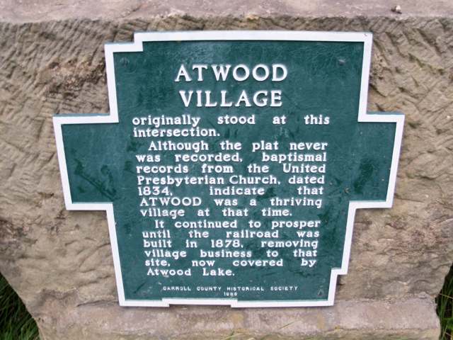
Photo: Roseohioresident, Wikimedia Commons, public domain · Wikimedia Commons
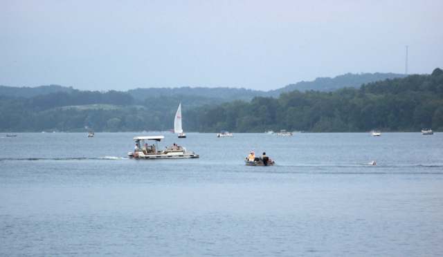
Photo: Roseohioresident, Wikimedia Commons, public domain · Wikimedia Commons
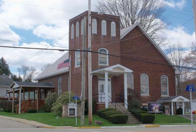
Photo: Roseohioresident, Wikimedia Commons, CC BY-SA 4.0 · Wikimedia Commons
Local history sources: ohiogenealogyexpress.com · en.wikipedia.org · en.wikipedia.org · en.wikipedia.org · en.wikipedia.org · archive.org
Water
Mostly private wells The water here
- Fohl Village MHP54% of residentsGroundwater wells (2 wells)
- Carrollton Village40% of residentsGroundwater wells (10 wells)
- Bowerston Village5% of residentsGroundwater wells (3 wells)
- Rockwood Park1% of residentsGroundwater wells (2 wells)
Hospitals, fire stations and more
Inside Monroe Township, Carroll County's boundary: 1 poor-rated bridge, 2 public charging sites, 28 shale and injection wells and 6 spill cases. Press a pin or a name for its whole record and its source.
Bridges rated poor (1)
-
Mon Twp Rd 158 over Indian Fork Easterdoy 30Poor · built 1975
- Condition
- Poor: a deck, superstructure, substructure or culvert rated 4 or below on the 0 to 9 scale
- What it is
- Bridge
- Built
- 1975
- Length
- 15 ft
- Owner
- County
- Vehicles a day
- 209
- Coordinates
- 40.55130, -81.17410
National Bridge Inventory (source) ↗ Street map and directions ↗
Source: FHWA National Bridge Inventory 2025. "Poor" means one major part rated 4 or below on the 0 to 9 scale; it calls for repair, not closing, unless the state posts or closes the bridge.
Public EV charging (2)
-
CE CHARGEPOINT CE STATION 12 Level 2 · Dellroy
- Address
- 1601 Magnolia Rd SW, Dellroy, OH 44620
- Ports
- 2 Level 2
- Plugs
- J1772
- Network
- ChargePoint Network
- Hours
- 24 hours daily
- Phone
- 888-758-4389
Station Locator (NREL) ↗ Alternative Fuels Data Center (source) ↗ Street map and directions ↗
-
Whispering Pines Bed & Breakfast - Tesla Destination2 Level 2 · Dellroy
- Address
- 1268 Magnolia Rd SW, Dellroy, OH 44620
- Ports
- 2 Level 2
- Plugs
- J1772, Tesla (NACS)
- Network
- Tesla Destination
- Phone
- 877-798-3752
Station Locator (NREL) ↗ Alternative Fuels Data Center (source) ↗ Street map and directions ↗
Source: NREL Alternative Fuels Data Center station list (May 2026), public and open stations, the posts at one address counted as one site.
Shale and injection wells (28)
-
Hollyfield Cr Mon 10HUtica shale well
- What it is
- Utica shale well
- Drilled sideways
- Yes
- Operator
- Eog Ohio, Llc
- County
- Carroll County
- API well number
- 34019229180000
- Coordinates
- 40.54896, -81.19743
ODNR oil and gas wells (source) ↗ Street map and directions ↗
The point is the surface well head (the pad); a horizontal well runs a mile or more underground from it.
-
Hollyfield Cr Mon 210HUtica shale well
- What it is
- Utica shale well
- Drilled sideways
- Yes
- Operator
- Eog Ohio, Llc
- County
- Carroll County
- API well number
- 34019229190000
- Coordinates
- 40.54893, -81.19737
ODNR oil and gas wells (source) ↗ Street map and directions ↗
The point is the surface well head (the pad); a horizontal well runs a mile or more underground from it.
-
Hollyfield Cr Mon 6HUtica shale well
- What it is
- Utica shale well
- Drilled sideways
- Yes
- Operator
- Eog Ohio, Llc
- County
- Carroll County
- API well number
- 34019229160000
- Coordinates
- 40.54903, -81.19755
ODNR oil and gas wells (source) ↗ Street map and directions ↗
The point is the surface well head (the pad); a horizontal well runs a mile or more underground from it.
-
Hollyfield Cr Mon 8HUtica shale well
- What it is
- Utica shale well
- Drilled sideways
- Yes
- Operator
- Eog Ohio, Llc
- County
- Carroll County
- API well number
- 34019229170000
- Coordinates
- 40.54899, -81.19749
ODNR oil and gas wells (source) ↗ Street map and directions ↗
The point is the surface well head (the pad); a horizontal well runs a mile or more underground from it.
-
Krantz Cr Mon 1HHorizontal shale well
- What it is
- Horizontal shale well
- Drilled sideways
- Yes
- Operator
- Eog Ohio, Llc
- County
- Carroll County
- API well number
- 34019228180000
- Coordinates
- 40.50709, -81.20092
ODNR oil and gas wells (source) ↗ Street map and directions ↗
The point is the surface well head (the pad); a horizontal well runs a mile or more underground from it.
-
Krantz Cr Mon 3HHorizontal shale well
- What it is
- Horizontal shale well
- Drilled sideways
- Yes
- Operator
- Eog Ohio, Llc
- County
- Carroll County
- API well number
- 34019228190000
- Coordinates
- 40.50713, -81.20086
ODNR oil and gas wells (source) ↗ Street map and directions ↗
The point is the surface well head (the pad); a horizontal well runs a mile or more underground from it.
-
Krantz Cr Mon 5HHorizontal shale well
- What it is
- Horizontal shale well
- Drilled sideways
- Yes
- Operator
- Eog Ohio, Llc
- County
- Carroll County
- API well number
- 34019228200000
- Coordinates
- 40.50716, -81.20081
ODNR oil and gas wells (source) ↗ Street map and directions ↗
The point is the surface well head (the pad); a horizontal well runs a mile or more underground from it.
-
Krantz Cr Mon 7HHorizontal shale well
- What it is
- Horizontal shale well
- Drilled sideways
- Yes
- Operator
- Eog Ohio, Llc
- County
- Carroll County
- API well number
- 34019228210000
- Coordinates
- 40.50719, -81.20075
ODNR oil and gas wells (source) ↗ Street map and directions ↗
The point is the surface well head (the pad); a horizontal well runs a mile or more underground from it.
-
Oliver Cr Mon 1HUtica shale well
- What it is
- Utica shale well
- Drilled sideways
- Yes
- Operator
- Eog Ohio, Llc
- County
- Carroll County
- API well number
- 34019228440000
- Coordinates
- 40.51829, -81.18347
ODNR oil and gas wells (source) ↗ Street map and directions ↗
The point is the surface well head (the pad); a horizontal well runs a mile or more underground from it.
-
Oliver Cr Mon 201HUtica shale well
- What it is
- Utica shale well
- Drilled sideways
- Yes
- Operator
- Eog Ohio, Llc
- County
- Carroll County
- API well number
- 34019228470000
- Coordinates
- 40.51823, -81.18348
ODNR oil and gas wells (source) ↗ Street map and directions ↗
The point is the surface well head (the pad); a horizontal well runs a mile or more underground from it.
-
Oliver Cr Mon 3HUtica shale well
- What it is
- Utica shale well
- Drilled sideways
- Yes
- Operator
- Eog Ohio, Llc
- County
- Carroll County
- API well number
- 34019228450000
- Coordinates
- 40.51834, -81.18347
ODNR oil and gas wells (source) ↗ Street map and directions ↗
The point is the surface well head (the pad); a horizontal well runs a mile or more underground from it.
-
Oliver Cr Mon 5HUtica shale well
- What it is
- Utica shale well
- Drilled sideways
- Yes
- Operator
- Eog Ohio, Llc
- County
- Carroll County
- API well number
- 34019228460000
- Coordinates
- 40.51840, -81.18347
ODNR oil and gas wells (source) ↗ Street map and directions ↗
The point is the surface well head (the pad); a horizontal well runs a mile or more underground from it.
-
Toot Cr Mon 1HUtica shale well
- What it is
- Utica shale well
- Drilled sideways
- Yes
- Operator
- Eog Ohio, Llc
- County
- Carroll County
- API well number
- 34019228770000
- Coordinates
- 40.54300, -81.17947
ODNR oil and gas wells (source) ↗ Street map and directions ↗
The point is the surface well head (the pad); a horizontal well runs a mile or more underground from it.
-
Toot Cr Mon 205HUtica shale well
- What it is
- Utica shale well
- Drilled sideways
- Yes
- Operator
- Eog Ohio, Llc
- County
- Carroll County
- API well number
- 34019228800000
- Coordinates
- 40.54301, -81.17968
ODNR oil and gas wells (source) ↗ Street map and directions ↗
The point is the surface well head (the pad); a horizontal well runs a mile or more underground from it.
-
Toot Cr Mon 3HUtica shale well
- What it is
- Utica shale well
- Drilled sideways
- Yes
- Operator
- Eog Ohio, Llc
- County
- Carroll County
- API well number
- 34019228780000
- Coordinates
- 40.54301, -81.17961
ODNR oil and gas wells (source) ↗ Street map and directions ↗
The point is the surface well head (the pad); a horizontal well runs a mile or more underground from it.
-
Toot Cr Mon 5HUtica shale well
- What it is
- Utica shale well
- Drilled sideways
- Yes
- Operator
- Eog Ohio, Llc
- County
- Carroll County
- API well number
- 34019228790000
- Coordinates
- 40.54300, -81.17954
ODNR oil and gas wells (source) ↗ Street map and directions ↗
The point is the surface well head (the pad); a horizontal well runs a mile or more underground from it.
-
Watkins Cr Mon 10HUtica shale well
- What it is
- Utica shale well
- Drilled sideways
- Yes
- Operator
- Eog Ohio, Llc
- County
- Carroll County
- API well number
- 34019229460000
- Coordinates
- 40.52756, -81.19851
ODNR oil and gas wells (source) ↗ Street map and directions ↗
The point is the surface well head (the pad); a horizontal well runs a mile or more underground from it.
-
Watkins Cr Mon 210HUtica shale well
- What it is
- Utica shale well
- Drilled sideways
- Yes
- Operator
- Eog Ohio, Llc
- County
- Carroll County
- API well number
- 34019229470000
- Coordinates
- 40.52756, -81.19843
ODNR oil and gas wells (source) ↗ Street map and directions ↗
The point is the surface well head (the pad); a horizontal well runs a mile or more underground from it.
-
Watkins Cr Mon 6HUtica shale well
- What it is
- Utica shale well
- Drilled sideways
- Yes
- Operator
- Eog Ohio, Llc
- County
- Carroll County
- API well number
- 34019229440000
- Coordinates
- 40.52757, -81.19865
ODNR oil and gas wells (source) ↗ Street map and directions ↗
The point is the surface well head (the pad); a horizontal well runs a mile or more underground from it.
-
Watkins Cr Mon 8HUtica shale well
- What it is
- Utica shale well
- Drilled sideways
- Yes
- Operator
- Eog Ohio, Llc
- County
- Carroll County
- API well number
- 34019229450000
- Coordinates
- 40.52757, -81.19858
ODNR oil and gas wells (source) ↗ Street map and directions ↗
The point is the surface well head (the pad); a horizontal well runs a mile or more underground from it.
-
Wiliams Cr Mon 6HUtica shale well
- What it is
- Utica shale well
- Drilled sideways
- Yes
- Operator
- Eog Ohio, Llc
- County
- Carroll County
- API well number
- 34019227610000
- Coordinates
- 40.54644, -81.16051
ODNR oil and gas wells (source) ↗ Street map and directions ↗
The point is the surface well head (the pad); a horizontal well runs a mile or more underground from it.
-
Williams Cr Mon 1HHorizontal shale well
- What it is
- Horizontal shale well
- Drilled sideways
- Yes
- Operator
- Eog Ohio, Llc
- County
- Carroll County
- API well number
- 34019228060000
- Coordinates
- 40.54637, -81.16052
ODNR oil and gas wells (source) ↗ Street map and directions ↗
The point is the surface well head (the pad); a horizontal well runs a mile or more underground from it.
-
Williams Cr Mon 201HUtica shale well
- What it is
- Utica shale well
- Drilled sideways
- Yes
- Operator
- Eog Ohio, Llc
- County
- Carroll County
- API well number
- 34019229420000
- Coordinates
- 40.54653, -81.16042
ODNR oil and gas wells (source) ↗ Street map and directions ↗
The point is the surface well head (the pad); a horizontal well runs a mile or more underground from it.
-
Williams Cr Mon 205HHorizontal shale well
- What it is
- Horizontal shale well
- Drilled sideways
- Yes
- Operator
- Eog Ohio, Llc
- County
- Carroll County
- API well number
- 34019228090000
- Coordinates
- 40.54641, -81.16031
ODNR oil and gas wells (source) ↗ Street map and directions ↗
The point is the surface well head (the pad); a horizontal well runs a mile or more underground from it.
-
Williams Cr Mon 301HUtica shale well
- What it is
- Utica shale well
- Drilled sideways
- Yes
- Operator
- Eog Ohio, Llc
- County
- Carroll County
- API well number
- 34019229430000
- Coordinates
- 40.54652, -81.16049
ODNR oil and gas wells (source) ↗ Street map and directions ↗
The point is the surface well head (the pad); a horizontal well runs a mile or more underground from it.
-
Williams Cr Mon 3HHorizontal shale well
- What it is
- Horizontal shale well
- Drilled sideways
- Yes
- Operator
- Eog Ohio, Llc
- County
- Carroll County
- API well number
- 34019228070000
- Coordinates
- 40.54638, -81.16045
ODNR oil and gas wells (source) ↗ Street map and directions ↗
The point is the surface well head (the pad); a horizontal well runs a mile or more underground from it.
-
Williams Cr Mon 5HHorizontal shale well
- What it is
- Horizontal shale well
- Drilled sideways
- Yes
- Operator
- Eog Ohio, Llc
- County
- Carroll County
- API well number
- 34019228080000
- Coordinates
- 40.54639, -81.16038
ODNR oil and gas wells (source) ↗ Street map and directions ↗
The point is the surface well head (the pad); a horizontal well runs a mile or more underground from it.
-
Williams Cr Mon 8HUtica shale well
- What it is
- Utica shale well
- Drilled sideways
- Yes
- Operator
- Eog Ohio, Llc
- County
- Carroll County
- API well number
- 34019227620000
- Coordinates
- 40.54646, -81.16044
ODNR oil and gas wells (source) ↗ Street map and directions ↗
The point is the surface well head (the pad); a horizontal well runs a mile or more underground from it.
Source: ODNR Division of Oil and Gas Resources well inventory (September 2026): drilled Utica, Marcellus and horizontal wells and Class II injection wells not plugged. Older vertical wells are on the full map.
Spills reported since 2021 (6)
-
Oil Hydraulic Fluid(S)2025-06-06 · Monroe Twp
- Reported
- 2025-06-06
- What spilled
- Oil Hydraulic Fluid(S)
- Where
- Monroe Twp, Carroll County
- Ohio EPA district office
- NEDO
- Ohio EPA case number
- 2506EPA0000926
Ohio EPA spill reports (source) ↗ Street map and directions ↗
-
Sewage Human2023-08-12 · Monroe Twp
- Reported
- 2023-08-12
- What spilled
- Sewage Human
- Where
- Monroe Twp, Carroll County
- Ohio EPA district office
- NEDO
- Ohio EPA case number
- 2308EPA0001389
Ohio EPA spill reports (source) ↗ Street map and directions ↗
-
Fuel Diesel / Diesel Fuel (Vehicle On Or Off Road)2023-04-10 · Monroe Twp
- Reported
- 2023-04-10
- What spilled
- Fuel Diesel / Diesel Fuel (Vehicle On Or Off Road)
- Largest amount reported
- 40 gallons
- Where
- Monroe Twp, Carroll County
- Ohio EPA district office
- NEDO
- Ohio EPA case number
- 2304EPA0000546
Ohio EPA spill reports (source) ↗ Street map and directions ↗
-
Oil Crude2022-03-24 · Monroe Twp
- Reported
- 2022-03-24
- What spilled
- Oil Crude
- Largest amount reported
- 200 gallons
- Where
- Monroe Twp, Carroll County
- Ohio EPA district office
- NEDO
- Ohio EPA case number
- 2203EPA0000407
Ohio EPA spill reports (source) ↗ Street map and directions ↗
-
Oil Crude Reached water2021-05-07 · Monroe Twp
- Reported
- 2021-05-07
- What spilled
- Oil Crude
- Reached a waterway
- 10 - Thompson Run
- Where
- Monroe Twp, Carroll County
- Ohio EPA district office
- NEDO
- Ohio EPA case number
- 2105EPA0000642
Ohio EPA spill reports (source) ↗ Street map and directions ↗
-
Oil Crude2026-03-27 · Monroe Twp
- Reported
- 2026-03-27
- What spilled
- Oil Crude
- Largest amount reported
- 210 gallons
- Where
- Monroe Twp, Carroll County
- Ohio EPA district office
- NEDO
- Ohio EPA case number
- 2603EPA0000499
Ohio EPA spill reports (source) ↗ Street map and directions ↗
Source: Ohio EPA emergency response spill reports, 2021 to September 2026, one point per case where Ohio EPA placed it. A report is what the caller or responder recorded; amounts are often blank or estimated.
Its ZIP codes
Each ZIP code that touches Monroe Township, Carroll County, with the share of its residents who live here and the same headline figures as the ZIP page.
| ZIP | Share | Water | Radon | Home value | Schools | Flood |
|---|---|---|---|---|---|---|
| 44675 Monroe Township and Sherrodsville | 54% | Mostly private wells | 10.7 pCi/L average radon | Median year built 1974 | Conotton Valley Union Local · 4.5 stars overall | 3.8% of residents in the 1% floodplain |
| 44620 Rose Township and Dellroy | 23% | Mostly private wells | 11.5 pCi/L average radon | Median year built 1978 | Carrollton Exempted Village · 4 stars overall | 2.9% of residents in the 1% floodplain |
| 44695 Orange Township and Bowerston | 4% | Mostly private wells | 7.5 pCi/L average radon | Median year built 1963 | Conotton Valley Union Local · 4.5 stars overall | 9.1% of residents in the 1% floodplain |
| 44615 Carrollton | 2% | Mostly private wells | 7.9 pCi/L average radon | Median year built 1969 | Carrollton Exempted Village · 4 stars overall | 1.3% of residents in the 1% floodplain |
The county
Carroll County: 7 ZIP codes, 15 cities, villages and townships, 19,207 people.
Nearby places
Quick answers
What county is Monroe Township, Ohio in?
Monroe Township, Carroll County is a township in Carroll County, Ohio, with 1,632 residents.
When was Monroe Township, Ohio founded?
Monroe Township, Carroll County was incorporated 1833 (organized at the first Carroll County commissioners' session, held at David J. Levy's tavern in Carrollton). Source
How did Monroe Township, Ohio get its name?
Named for President James Monroe, who as president signed many of the first federal land patents and warrants issued to the township's early settlers. Source
What ZIP code is Monroe Township, Ohio?
Monroe Township, Carroll County is served by ZIP codes 44675, 44620, 44695 and 44615; 44675 holds the largest share of its residents.
Where does Monroe Township, Ohio get its water?
The main water source for Monroe Township, Carroll County (Fohl Village MHP): Mostly private wells.
Cite this page
Cite this page as:
Cracked Buckeye, "Monroe Township, Carroll County", https://crackedbuckeye.com/place/monroe-township-carroll-county/, built 2026-10-31, accessed [date].
How to cite · Report a correction · Built 2026-10-31
