Local events in Orange Township, Carroll County
Nothing is posted for Orange Township itself yet; here is what is on within 20 miles. All local events in Orange Township, Carroll County
Know a calendar we should watch? Send the link
Checked October 20; the events page is refreshed daily.
Lakes near Orange Township, Carroll County
The history under the water: the valley before, the dam, the stories. All Ohio lakes
How Orange Township, Carroll County began
Orange Township, in southwestern Carroll County along Conotton Creek, began as part of One-leg Township, Tuscarawas County, organized March 29, 1809, and was renamed and reorganized as Orange Township when Carroll County was formed in 1833. No source read explains the name Orange; the creek it straddles still carries the name of the 'one-legged Indian' the pioneers said had lived along its banks. The township holds two villages, Leesville and part of Sherrodsville, and was reshaped in the 1930s and 1936 by the federal damming of Conotton Creek's McGuire Fork to form Leesville Lake, one of the Muskingum Watershed Conservancy District's flood-control reservoirs.
Settled early 1800s, incorporated 1833 (as Orange Township, successor to One-leg Township, organized March 29, 1809), by Tuscarawas County (1809 organization), reorganized under Carroll County in 1833.
Where the name comes from
Orange Township was carved from the former One-leg Township, Tuscarawas County, whose own name came from Conotton Creek's earlier name, 'One Leg' - after a one-legged Native man who reportedly lived along its banks before white settlement.
Before the town
The township's clearest Native reference survives in a place name rather than a site: Conotton Creek, which runs the length of the township, was known to early settlers as 'One Leg' creek, after a one-legged Native man who was said to have lived along it, and the township that preceded Orange Township took that name outright. No mound or earthwork has been documented within the township, and no county-level file yet exists for Carroll County to check further. Before removal, the Lenape (Delaware) and Wyandot both hunted and traveled the Conotton and Tuscarawas valleys that cross this ground; the land was ceded to the United States by the Treaty of Fort McIntosh (1785), which the Wyandot, Lenape, Ojibwe, and Ottawa were pressured into signing.
Nations recorded here: Lenape (Delaware), Wyandot.
- 'One Leg' (Conotton Creek) (other) — Conotton Creek, running through Orange Township, pre-settlement, undated (en.wikipedia.org)
Timeline
- — One-leg Township, the predecessor of Orange Township, is organized under Tuscarawas County.
- — Thomas Price and Peter Saunders plat the village of Leesburg (later Leesville) on Conotton Creek in what is now the township's south end.
- — Carroll County is formed and One-leg Township is reorganized as Orange Township.
- — The New Hagerstown Academy opens in the township, operating through most of the 19th century.
- before Civil War — Orange Township serves as an Underground Railroad corridor: Joseph S. Burr and Joseph Millesack conduct fugitives from Port Washington through Leesville and on to Salem via Baxter's Ridge.
- — John and Allen Pearch plat the village of Sherrodsville, named for landowner Charles Sherrod, in the township's northwest corner.
- — The Muskingum Watershed Conservancy District completes the Leesville Lake dam on McGuire Fork of Conotton Creek at a cost of $941,000, forming a 1,000-acre flood-control reservoir named for the village.
Stories
The judge from New Hagerstown
James Latimer Price was born in 1840 near New Hagerstown, the little Orange Township settlement the 1921 county history already called 'of minor importance' and now defunct. He left the township for the law, was elected a Republican judge, and in 1902 took a seat on the Ohio Supreme Court, where he served until his death in 1912. His career is the rare case of a name from this rural township reaching the state's highest bench, and it stands almost alone against a local record otherwise made up of coal royalties, creek-bottom farms, and a vanished academy.
A creek dammed twice for one township
Orange Township's two lakes were both built by the same New Deal-era agency for the same reason. In 1936 the Muskingum Watershed Conservancy District closed Leesville Lake dam on McGuire Fork, just north of the village of Leesville, to hold back Conotton Creek's floodwater after the catastrophic 1913 Ohio flood had shown what the unregulated Muskingum system could do. The reservoir it created covers roughly 1,000 acres at full pool and today draws recreational boaters and anglers to a township that a century earlier measured its economy in coal-mine payrolls - $40,000 a month around 1905, down to $8,000 by 1920 as the seams played out.
Photographs
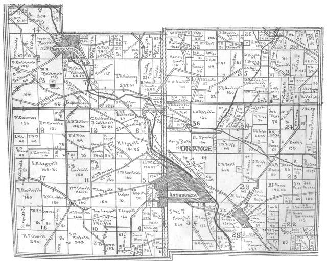
Photo: Linn Boyd Atkinson (1894 map); photographed by Roseohioresident, public domain · Wikimedia Commons
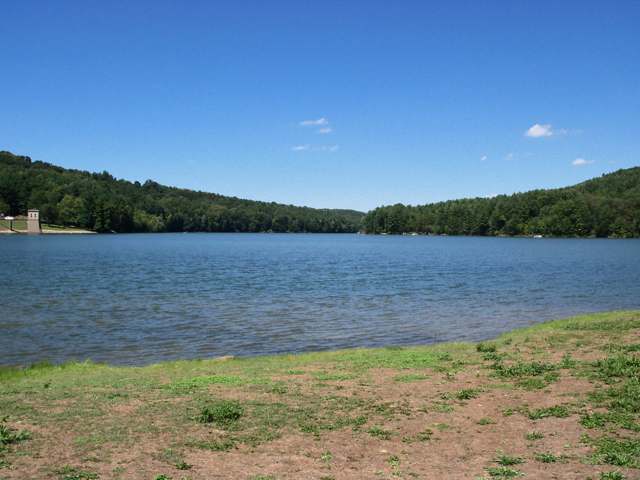
Photo: Roseohioresident, Wikimedia Commons, public domain · Wikimedia Commons
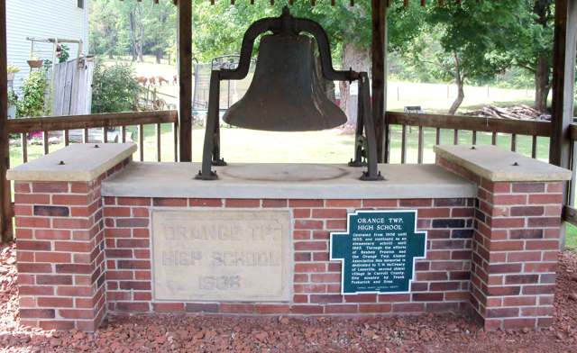
Photo: Roseohioresident, Wikimedia Commons, public domain · Wikimedia Commons
Local history sources: ohiogenealogyexpress.com · en.wikipedia.org · en.wikipedia.org · en.wikipedia.org · en.wikipedia.org · en.wikipedia.org · commons.wikimedia.org · commons.wikimedia.org · commons.wikimedia.org
Water
Mostly private wells The water here
- Bowerston Village48% of residentsGroundwater wells (3 wells)
- Twin City Water and Sewer District23% of residentsTuscarawas River valley aquifer (local wells)
- Carrollton Village20% of residentsGroundwater wells (10 wells)
- Fohl Village MHP8% of residentsGroundwater wells (2 wells)
- Aqua Ohio - Midvale0% of residentsGroundwater wells (3 wells)
- Rockwood Park0% of residentsGroundwater wells (2 wells)
Hospitals, fire stations and more
Inside Orange Township, Carroll County's boundary: 1 nursing home, 1 fire or EMS station, 1 high-hazard dam, 2 public schools, 1 poor-rated bridge, 52 shale and injection wells, 1 Toxics Release Inventory facility and 7 spill cases. Press a pin or a name for its whole record and its source.
Nursing homes (1)
-
Bowerston Hills Nursing & Rehabilitation5 of 5 stars · Bowerston
- Address
- 9076 Cumberland Road, Bowerston, OH 44695
- Certified beds
- 25
- Residents on an average day
- 20
- Medicare overall rating
- 5 of 5 stars
- Health inspections
- 5 of 5 stars
- Staffing
- 2 of 5 stars
- Quality measures
- 5 of 5 stars
- Penalties since 2023
- none
- Ownership
- For profit - Corporation
- Chain
- HILLSTONE HEALTHCARE
- Takes
- Medicare and Medicaid
- Phone
- (740) 269-4000
- Medicare ID
- 366037
Medicare Care Compare ↗ CMS nursing home data (source) ↗ Street map and directions ↗
Source: CMS Care Compare nursing home provider and penalties files; Medicare star ratings run 1 to 5.
Fire and EMS stations (1)
-
Sherrodsville Volunteer Fire DepartmentSherrodsville
- Address
- 8183 Stover Road, Sherrodsville, OH 44675
- Coordinates
- 40.48470, -81.26293
USGS National Map structures (source) ↗ Street map and directions ↗
Source: USGS National Map structures (most Ohio records last updated 2019 to 2022), checked against the Columbus and Cleveland station lists. The department that answers a call is set by jurisdiction and mutual aid, not by distance.
High-hazard dams (1)
-
Leesville DamMcguire Creek · condition: not available
- Hazard class
- High: a failure would probably cost a life
- Condition
- Not Available
- River or stream
- Mcguire Creek
- Purpose
- Flood Risk Reduction;Fish and Wildlife Pond;Recreation
- Type
- Earth
- Height
- 74 ft
- Storage
- 37,400 acre-feet
- Completed
- 1937
- Owner type
- Federal
- County
- Carroll County
- Nearest town (NID)
- Sherrodville
- Last inspection
- 04/27/2023
- Emergency action plan
- Yes
- NID ID
- OH00014
National Inventory of Dams record ↗ National Inventory of Dams (source) ↗ Street map and directions ↗
Source: U.S. Army Corps of Engineers National Inventory of Dams, August 2026. "High hazard" rates what a failure would cost downstream, not how likely one is; the condition is the state's assessment.
Public schools (2)
-
Conotton Valley Elementary4.5 of 5 stars · Bowerston
- Address
- 7205 Cumberland Rd SW, Bowerston, OH 44695
- School district
- Conotton Valley Union Local School District
- Kind (NCES)
- Regular School
- Students, 2023-24
- 286
- Teachers (full-time equivalent)
- 15
- Report card, 2025-26
- 4.5 of 5 stars
- Performance index
- 86.3%
- Ohio building IRN
- 003277
- NCES school ID
- 390475402914
NCES school record ↗ Ohio School Report Card ↗ Street map and directions ↗
-
Conotton Valley High School4.5 of 5 stars · Bowerston
- Address
- 7205 Cumberland Rd SW, Bowerston, OH 44695
- School district
- Conotton Valley Union Local School District
- Kind (NCES)
- Regular School
- Students, 2023-24
- 218
- Teachers (full-time equivalent)
- 19
- Report card, 2025-26
- 4.5 of 5 stars
- Performance index
- 81.1%
- Four-year graduation rate
- 95%
- Ohio building IRN
- 007245
- NCES school ID
- 390475402916
NCES school record ↗ Ohio School Report Card ↗ Street map and directions ↗
Source: NCES EDGE public school locations 2024-25 and Common Core of Data 2023-24 (type, students, teachers); Ohio School Report Cards 2025-26 (Department of Education and Workforce), matched by name within the district.
Bridges rated poor (1)
-
Orange Twp 111 over Connotton Cr Hadorn Bn07Poor · built 1955
- Condition
- Poor: a deck, superstructure, substructure or culvert rated 4 or below on the 0 to 9 scale
- What it is
- Bridge
- Built
- 1955
- Length
- 19 ft
- Owner
- County
- Vehicles a day
- 324
- Coordinates
- 40.48250, -81.24194
National Bridge Inventory (source) ↗ Street map and directions ↗
Source: FHWA National Bridge Inventory 2025. "Poor" means one major part rated 4 or below on the 0 to 9 scale; it calls for repair, not closing, unless the state posts or closes the bridge.
Shale and injection wells (52)
-
Delmar 24-13-6 2HUtica shale well
- What it is
- Utica shale well
- Drilled sideways
- Yes
- Operator
- Eog Ohio, Llc
- County
- Carroll County
- API well number
- 34019226990000
- Coordinates
- 40.47376, -81.16532
ODNR oil and gas wells (source) ↗ Street map and directions ↗
The point is the surface well head (the pad); a horizontal well runs a mile or more underground from it.
-
Delmar 24-13-6 3HUtica shale well
- What it is
- Utica shale well
- Drilled sideways
- Yes
- Operator
- Eog Ohio, Llc
- County
- Carroll County
- API well number
- 34019222710000
- Coordinates
- 40.47373, -81.16526
ODNR oil and gas wells (source) ↗ Street map and directions ↗
The point is the surface well head (the pad); a horizontal well runs a mile or more underground from it.
-
Delmar 24-13-6 4HUtica shale well
- What it is
- Utica shale well
- Drilled sideways
- Yes
- Operator
- Eog Ohio, Llc
- County
- Carroll County
- API well number
- 34019227010000
- Coordinates
- 40.47369, -81.16521
ODNR oil and gas wells (source) ↗ Street map and directions ↗
The point is the surface well head (the pad); a horizontal well runs a mile or more underground from it.
-
Delmar 24-13-6 5HUtica shale well
- What it is
- Utica shale well
- Drilled sideways
- Yes
- Operator
- Eog Ohio, Llc
- County
- Carroll County
- API well number
- 34019227000000
- Coordinates
- 40.47366, -81.16515
ODNR oil and gas wells (source) ↗ Street map and directions ↗
The point is the surface well head (the pad); a horizontal well runs a mile or more underground from it.
-
Delmar 24-13-6 6HUtica shale well
- What it is
- Utica shale well
- Drilled sideways
- Yes
- Operator
- Eog Ohio, Llc
- County
- Carroll County
- API well number
- 34019226940000
- Coordinates
- 40.47383, -81.16543
ODNR oil and gas wells (source) ↗ Street map and directions ↗
The point is the surface well head (the pad); a horizontal well runs a mile or more underground from it.
-
Delmar 24-13-6 7HUtica shale well
- What it is
- Utica shale well
- Drilled sideways
- Yes
- Operator
- Eog Ohio, Llc
- County
- Carroll County
- API well number
- 34019226930000
- Coordinates
- 40.47379, -81.16537
ODNR oil and gas wells (source) ↗ Street map and directions ↗
The point is the surface well head (the pad); a horizontal well runs a mile or more underground from it.
-
Donald 22-13-6 6HUtica shale well
- What it is
- Utica shale well
- Drilled sideways
- Yes
- Operator
- Eog Ohio, Llc
- County
- Carroll County
- API well number
- 34019225980000
- Coordinates
- 40.43476, -81.16136
ODNR oil and gas wells (source) ↗ Street map and directions ↗
The point is the surface well head (the pad); a horizontal well runs a mile or more underground from it.
-
Donald 22-13-6 7HUtica shale well
- What it is
- Utica shale well
- Drilled sideways
- Yes
- Operator
- Eog Ohio, Llc
- County
- Carroll County
- API well number
- 34019227280000
- Coordinates
- 40.43470, -81.16136
ODNR oil and gas wells (source) ↗ Street map and directions ↗
The point is the surface well head (the pad); a horizontal well runs a mile or more underground from it.
-
Donald 22-13-6 9HUtica shale well
- What it is
- Utica shale well
- Drilled sideways
- Yes
- Operator
- Eog Ohio, Llc
- County
- Carroll County
- API well number
- 34019227310000
- Coordinates
- 40.43459, -81.16137
ODNR oil and gas wells (source) ↗ Street map and directions ↗
The point is the surface well head (the pad); a horizontal well runs a mile or more underground from it.
-
Edison Ruby Cr Org 10HUtica shale well
- What it is
- Utica shale well
- Drilled sideways
- Yes
- Operator
- Eog Ohio, Llc
- County
- Carroll County
- API well number
- 34019227730000
- Coordinates
- 40.45561, -81.22218
ODNR oil and gas wells (source) ↗ Street map and directions ↗
The point is the surface well head (the pad); a horizontal well runs a mile or more underground from it.
-
Edison Ruby Cr Org 1HUtica shale well
- What it is
- Utica shale well
- Drilled sideways
- Yes
- Operator
- Eog Ohio, Llc
- County
- Carroll County
- API well number
- 34019228270000
- Coordinates
- 40.45515, -81.22233
ODNR oil and gas wells (source) ↗ Street map and directions ↗
The point is the surface well head (the pad); a horizontal well runs a mile or more underground from it.
-
Edison Ruby Cr Org 205HUtica shale well
- What it is
- Utica shale well
- Drilled sideways
- Yes
- Operator
- Eog Ohio, Llc
- County
- Carroll County
- API well number
- 34019228300000
- Coordinates
- 40.45515, -81.22211
ODNR oil and gas wells (source) ↗ Street map and directions ↗
The point is the surface well head (the pad); a horizontal well runs a mile or more underground from it.
-
Edison Ruby Cr Org 210HUtica shale well
- What it is
- Utica shale well
- Drilled sideways
- Yes
- Operator
- Eog Ohio, Llc
- County
- Carroll County
- API well number
- 34019227740000
- Coordinates
- 40.45561, -81.22210
ODNR oil and gas wells (source) ↗ Street map and directions ↗
The point is the surface well head (the pad); a horizontal well runs a mile or more underground from it.
-
Edison Ruby Cr Org 3HUtica shale well
- What it is
- Utica shale well
- Drilled sideways
- Yes
- Operator
- Eog Ohio, Llc
- County
- Carroll County
- API well number
- 34019228280000
- Coordinates
- 40.45515, -81.22226
ODNR oil and gas wells (source) ↗ Street map and directions ↗
The point is the surface well head (the pad); a horizontal well runs a mile or more underground from it.
-
Edison Ruby Cr Org 5HUtica shale well
- What it is
- Utica shale well
- Drilled sideways
- Yes
- Operator
- Eog Ohio, Llc
- County
- Carroll County
- API well number
- 34019228290000
- Coordinates
- 40.45515, -81.22218
ODNR oil and gas wells (source) ↗ Street map and directions ↗
The point is the surface well head (the pad); a horizontal well runs a mile or more underground from it.
-
Edison Ruby Cr Org 6HUtica shale well
- What it is
- Utica shale well
- Drilled sideways
- Yes
- Operator
- Eog Ohio, Llc
- County
- Carroll County
- API well number
- 34019227710000
- Coordinates
- 40.45561, -81.22232
ODNR oil and gas wells (source) ↗ Street map and directions ↗
The point is the surface well head (the pad); a horizontal well runs a mile or more underground from it.
-
Edison Ruby Cr Org 8HUtica shale well
- What it is
- Utica shale well
- Drilled sideways
- Yes
- Operator
- Eog Ohio, Llc
- County
- Carroll County
- API well number
- 34019227720000
- Coordinates
- 40.45561, -81.22225
ODNR oil and gas wells (source) ↗ Street map and directions ↗
The point is the surface well head (the pad); a horizontal well runs a mile or more underground from it.
-
Ellie 19-14-6 10HUtica shale well
- What it is
- Utica shale well
- Drilled sideways
- Yes
- Operator
- Eog Ohio, Llc
- County
- Carroll County
- API well number
- 34019227030000
- Coordinates
- 40.47846, -81.15727
ODNR oil and gas wells (source) ↗ Street map and directions ↗
The point is the surface well head (the pad); a horizontal well runs a mile or more underground from it.
-
Ellie 19-14-6 1HUtica shale well
- What it is
- Utica shale well
- Drilled sideways
- Yes
- Operator
- Eog Ohio, Llc
- County
- Carroll County
- API well number
- 34019227090000
- Coordinates
- 40.47833, -81.15739
ODNR oil and gas wells (source) ↗ Street map and directions ↗
The point is the surface well head (the pad); a horizontal well runs a mile or more underground from it.
-
Ellie 19-14-6 2HUtica shale well
- What it is
- Utica shale well
- Drilled sideways
- Yes
- Operator
- Eog Ohio, Llc
- County
- Carroll County
- API well number
- 34019227070000
- Coordinates
- 40.47839, -81.15738
ODNR oil and gas wells (source) ↗ Street map and directions ↗
The point is the surface well head (the pad); a horizontal well runs a mile or more underground from it.
-
Ellie 19-14-6 3HUtica shale well
- What it is
- Utica shale well
- Drilled sideways
- Yes
- Operator
- Eog Ohio, Llc
- County
- Carroll County
- API well number
- 34019227060000
- Coordinates
- 40.47824, -81.15732
ODNR oil and gas wells (source) ↗ Street map and directions ↗
The point is the surface well head (the pad); a horizontal well runs a mile or more underground from it.
-
Ellie 19-14-6 4HUtica shale well
- What it is
- Utica shale well
- Drilled sideways
- Yes
- Operator
- Eog Ohio, Llc
- County
- Carroll County
- API well number
- 34019227050000
- Coordinates
- 40.47835, -81.15729
ODNR oil and gas wells (source) ↗ Street map and directions ↗
The point is the surface well head (the pad); a horizontal well runs a mile or more underground from it.
-
Ellie 19-14-6 5HUtica shale well
- What it is
- Utica shale well
- Drilled sideways
- Yes
- Operator
- Eog Ohio, Llc
- County
- Carroll County
- API well number
- 34019227080000
- Coordinates
- 40.47830, -81.15731
ODNR oil and gas wells (source) ↗ Street map and directions ↗
The point is the surface well head (the pad); a horizontal well runs a mile or more underground from it.
-
Ellie 19-14-6 8HUtica shale well
- What it is
- Utica shale well
- Drilled sideways
- Yes
- Operator
- Eog Ohio, Llc
- County
- Carroll County
- API well number
- 34019227020000
- Coordinates
- 40.47844, -81.15736
ODNR oil and gas wells (source) ↗ Street map and directions ↗
The point is the surface well head (the pad); a horizontal well runs a mile or more underground from it.
-
Ellie 19-14-6 9HUtica shale well
- What it is
- Utica shale well
- Drilled sideways
- Yes
- Operator
- Eog Ohio, Llc
- County
- Carroll County
- API well number
- 34019227040000
- Coordinates
- 40.47840, -81.15728
ODNR oil and gas wells (source) ↗ Street map and directions ↗
The point is the surface well head (the pad); a horizontal well runs a mile or more underground from it.
-
Gartrell 23-13-6 10HUtica shale well · Drilling
- What it is
- Utica shale well
- Drilled sideways
- Yes
- Status (ODNR)
- Drilling
- Operator
- Eog Ohio, Llc
- County
- Carroll County
- API well number
- 34019227600000
- Coordinates
- 40.45143, -81.17639
ODNR oil and gas wells (source) ↗ Street map and directions ↗
The point is the surface well head (the pad); a horizontal well runs a mile or more underground from it.
-
Gartrell 23-13-6 6HUtica shale well · Drilling
- What it is
- Utica shale well
- Drilled sideways
- Yes
- Status (ODNR)
- Drilling
- Operator
- Eog Ohio, Llc
- County
- Carroll County
- API well number
- 34019227590000
- Coordinates
- 40.45146, -81.17644
ODNR oil and gas wells (source) ↗ Street map and directions ↗
The point is the surface well head (the pad); a horizontal well runs a mile or more underground from it.
-
Gartrell 23-13-6 8HUtica shale well
- What it is
- Utica shale well
- Drilled sideways
- Yes
- Operator
- Eog Ohio, Llc
- County
- Carroll County
- API well number
- 34019221560000
- Coordinates
- 40.45141, -81.17625
ODNR oil and gas wells (source) ↗ Street map and directions ↗
The point is the surface well head (the pad); a horizontal well runs a mile or more underground from it.
-
Kenneth Lloyd 5-14-7 10HUtica shale well
- What it is
- Utica shale well
- Drilled sideways
- Yes
- Operator
- Eog Ohio, Llc
- County
- Carroll County
- API well number
- 34019229150000
- Coordinates
- 40.45613, -81.21473
ODNR oil and gas wells (source) ↗ Street map and directions ↗
The point is the surface well head (the pad); a horizontal well runs a mile or more underground from it.
-
Kenneth Lloyd 5-14-7 205HUtica shale well
- What it is
- Utica shale well
- Drilled sideways
- Yes
- Operator
- Eog Ohio, Llc
- County
- Carroll County
- API well number
- 34019227670000
- Coordinates
- 40.45601, -81.21533
ODNR oil and gas wells (source) ↗ Street map and directions ↗
The point is the surface well head (the pad); a horizontal well runs a mile or more underground from it.
-
Kenneth Lloyd 5-14-7 3HUtica shale well
- What it is
- Utica shale well
- Drilled sideways
- Yes
- Operator
- Eog Ohio, Llc
- County
- Carroll County
- API well number
- 34019227700000
- Coordinates
- 40.45612, -81.21535
ODNR oil and gas wells (source) ↗ Street map and directions ↗
The point is the surface well head (the pad); a horizontal well runs a mile or more underground from it.
-
Kenneth Lloyd 5-14-7 5HUtica shale well
- What it is
- Utica shale well
- Drilled sideways
- Yes
- Operator
- Eog Ohio, Llc
- County
- Carroll County
- API well number
- 34019227680000
- Coordinates
- 40.45607, -81.21534
ODNR oil and gas wells (source) ↗ Street map and directions ↗
The point is the surface well head (the pad); a horizontal well runs a mile or more underground from it.
-
Kenneth Lloyd 5-14-7 6HUtica shale well
- What it is
- Utica shale well
- Drilled sideways
- Yes
- Operator
- Eog Ohio, Llc
- County
- Carroll County
- API well number
- 34019229130000
- Coordinates
- 40.45624, -81.21475
ODNR oil and gas wells (source) ↗ Street map and directions ↗
The point is the surface well head (the pad); a horizontal well runs a mile or more underground from it.
-
Kenneth Lloyd 5-14-7 8HUtica shale well
- What it is
- Utica shale well
- Drilled sideways
- Yes
- Operator
- Eog Ohio, Llc
- County
- Carroll County
- API well number
- 34019229140000
- Coordinates
- 40.45618, -81.21474
ODNR oil and gas wells (source) ↗ Street map and directions ↗
The point is the surface well head (the pad); a horizontal well runs a mile or more underground from it.
-
Kenneth Lloyd5-14-7 1HUtica shale well
- What it is
- Utica shale well
- Drilled sideways
- Yes
- Operator
- Eog Ohio, Llc
- County
- Carroll County
- API well number
- 34019227690000
- Coordinates
- 40.45618, -81.21536
ODNR oil and gas wells (source) ↗ Street map and directions ↗
The point is the surface well head (the pad); a horizontal well runs a mile or more underground from it.
-
Leeper Cr Org 10HHorizontal shale well
- What it is
- Horizontal shale well
- Drilled sideways
- Yes
- Operator
- Eog Ohio, Llc
- County
- Carroll County
- API well number
- 34019228040000
- Coordinates
- 40.45291, -81.26388
ODNR oil and gas wells (source) ↗ Street map and directions ↗
The point is the surface well head (the pad); a horizontal well runs a mile or more underground from it.
-
Leeper Cr Org 210HHorizontal shale well
- What it is
- Horizontal shale well
- Drilled sideways
- Yes
- Operator
- Eog Ohio, Llc
- County
- Carroll County
- API well number
- 34019228050000
- Coordinates
- 40.45290, -81.26381
ODNR oil and gas wells (source) ↗ Street map and directions ↗
The point is the surface well head (the pad); a horizontal well runs a mile or more underground from it.
-
Leeper Cr Org 6HHorizontal shale well
- What it is
- Horizontal shale well
- Drilled sideways
- Yes
- Operator
- Eog Ohio, Llc
- County
- Carroll County
- API well number
- 34019228020000
- Coordinates
- 40.45294, -81.26402
ODNR oil and gas wells (source) ↗ Street map and directions ↗
The point is the surface well head (the pad); a horizontal well runs a mile or more underground from it.
-
Leeper Cr Org 8HHorizontal shale well
- What it is
- Horizontal shale well
- Drilled sideways
- Yes
- Operator
- Eog Ohio, Llc
- County
- Carroll County
- API well number
- 34019228030000
- Coordinates
- 40.45293, -81.26395
ODNR oil and gas wells (source) ↗ Street map and directions ↗
The point is the surface well head (the pad); a horizontal well runs a mile or more underground from it.
-
Lloyd Smith 1-15-7 10HHorizontal shale well
- What it is
- Horizontal shale well
- Drilled sideways
- Yes
- Operator
- Eog Ohio, Llc
- County
- Carroll County
- API well number
- 34019227860000
- Coordinates
- 40.47407, -81.20466
ODNR oil and gas wells (source) ↗ Street map and directions ↗
The point is the surface well head (the pad); a horizontal well runs a mile or more underground from it.
-
Lloyd Smith 1-15-7 6HHorizontal shale well
- What it is
- Horizontal shale well
- Drilled sideways
- Yes
- Operator
- Eog Ohio, Llc
- County
- Carroll County
- API well number
- 34019227870000
- Coordinates
- 40.47397, -81.20471
ODNR oil and gas wells (source) ↗ Street map and directions ↗
The point is the surface well head (the pad); a horizontal well runs a mile or more underground from it.
-
Lloyd Smith 1-15-7 8HHorizontal shale well
- What it is
- Horizontal shale well
- Drilled sideways
- Yes
- Operator
- Eog Ohio, Llc
- County
- Carroll County
- API well number
- 34019227850000
- Coordinates
- 40.47402, -81.20468
ODNR oil and gas wells (source) ↗ Street map and directions ↗
The point is the surface well head (the pad); a horizontal well runs a mile or more underground from it.
-
Stephenson {Swiw#2} 1-D InjectionInjection well (Class II)
- What it is
- Injection well (Class II)
- Operator
- Downright Brine Disposal Llc
- County
- Carroll County
- API well number
- 34019207900000
- Coordinates
- 40.48268, -81.25188
ODNR oil and gas wells (source) ↗ Street map and directions ↗
-
Wendell Cr Org 1HHorizontal shale well
- What it is
- Horizontal shale well
- Drilled sideways
- Yes
- Operator
- Eog Ohio, Llc
- County
- Carroll County
- API well number
- 34019228130000
- Coordinates
- 40.49808, -81.20616
ODNR oil and gas wells (source) ↗ Street map and directions ↗
The point is the surface well head (the pad); a horizontal well runs a mile or more underground from it.
-
Wendell Cr Org 201HHorizontal shale well
- What it is
- Horizontal shale well
- Drilled sideways
- Yes
- Operator
- Eog Ohio, Llc
- County
- Carroll County
- API well number
- 34019228160000
- Coordinates
- 40.49808, -81.20595
ODNR oil and gas wells (source) ↗ Street map and directions ↗
The point is the surface well head (the pad); a horizontal well runs a mile or more underground from it.
-
Wendell Cr Org 205HHorizontal shale well
- What it is
- Horizontal shale well
- Drilled sideways
- Yes
- Operator
- Eog Ohio, Llc
- County
- Carroll County
- API well number
- 34019228170000
- Coordinates
- 40.49808, -81.20588
ODNR oil and gas wells (source) ↗ Street map and directions ↗
The point is the surface well head (the pad); a horizontal well runs a mile or more underground from it.
-
Wendell Cr Org 3HHorizontal shale well
- What it is
- Horizontal shale well
- Drilled sideways
- Yes
- Operator
- Eog Ohio, Llc
- County
- Carroll County
- API well number
- 34019228140000
- Coordinates
- 40.49808, -81.20609
ODNR oil and gas wells (source) ↗ Street map and directions ↗
The point is the surface well head (the pad); a horizontal well runs a mile or more underground from it.
-
Wendell Cr Org 5HHorizontal shale well
- What it is
- Horizontal shale well
- Drilled sideways
- Yes
- Operator
- Eog Ohio, Llc
- County
- Carroll County
- API well number
- 34019228150000
- Coordinates
- 40.49808, -81.20602
ODNR oil and gas wells (source) ↗ Street map and directions ↗
The point is the surface well head (the pad); a horizontal well runs a mile or more underground from it.
-
Windy Ridge Platform Cr Org 10HUtica shale well
- What it is
- Utica shale well
- Drilled sideways
- Yes
- Operator
- Eog Ohio, Llc
- County
- Carroll County
- API well number
- 34019227770000
- Coordinates
- 40.44597, -81.24504
ODNR oil and gas wells (source) ↗ Street map and directions ↗
The point is the surface well head (the pad); a horizontal well runs a mile or more underground from it.
-
Windy Ridge Platform Cr Org 210HUtica shale well
- What it is
- Utica shale well
- Drilled sideways
- Yes
- Operator
- Eog Ohio, Llc
- County
- Carroll County
- API well number
- 34019227780000
- Coordinates
- 40.44598, -81.24497
ODNR oil and gas wells (source) ↗ Street map and directions ↗
The point is the surface well head (the pad); a horizontal well runs a mile or more underground from it.
-
Windy Ridge Platform Cr Org 6HUtica shale well
- What it is
- Utica shale well
- Drilled sideways
- Yes
- Operator
- Eog Ohio, Llc
- County
- Carroll County
- API well number
- 34019227750000
- Coordinates
- 40.44595, -81.24518
ODNR oil and gas wells (source) ↗ Street map and directions ↗
The point is the surface well head (the pad); a horizontal well runs a mile or more underground from it.
-
Windy Ridge Platform Cr Org 8HUtica shale well
- What it is
- Utica shale well
- Drilled sideways
- Yes
- Operator
- Eog Ohio, Llc
- County
- Carroll County
- API well number
- 34019227760000
- Coordinates
- 40.44596, -81.24511
ODNR oil and gas wells (source) ↗ Street map and directions ↗
The point is the surface well head (the pad); a horizontal well runs a mile or more underground from it.
Source: ODNR Division of Oil and Gas Resources well inventory (September 2026): drilled Utica, Marcellus and horizontal wells and Class II injection wells not plugged. Older vertical wells are on the full map.
Facilities reporting toxic releases (1)
-
Leesville Cryogenic Processing PlantToxics Release Inventory · Dennison
- Address
- 8349 Azalea Rd, Dennison, OH 44621
- County
- Carroll County County
- Status
- Reports to the Toxics Release Inventory (***unchanged***)
- EPA program ID
- 4462WLSVLL8349A
- EPA registry ID
- 110067543466
EPA facility record ↗ EPA Facility Registry Service (source) ↗ Street map and directions ↗
Source: EPA Facility Registry Service, Toxics Release Inventory reporters. Reporting a release is required of large users of listed chemicals; it is not by itself a violation.
Spills reported since 2021 (7)
-
Oil Crude2024-03-11 · Orange Twp
- Reported
- 2024-03-11
- What spilled
- Oil Crude
- Largest amount reported
- 40 gallons
- Where
- Orange Twp, Carroll County
- Ohio EPA district office
- NEDO
- Ohio EPA case number
- 2403EPA0000385
Ohio EPA spill reports (source) ↗ Street map and directions ↗
-
Oil Crude2024-02-01 · Orange Twp
- Reported
- 2024-02-01
- What spilled
- Oil Crude
- Largest amount reported
- 5 gallons
- Where
- Orange Twp, Carroll County
- Ohio EPA district office
- NEDO
- Ohio EPA case number
- 2402EPA0000177
Ohio EPA spill reports (source) ↗ Street map and directions ↗
-
Oil Crude2023-05-16 · Orange Twp
- Reported
- 2023-05-16
- What spilled
- Oil Crude; Oil Petroleum Not Otherwise Specified (Nos)
- Where
- Orange Twp, Carroll County
- Ohio EPA district office
- NEDO
- Ohio EPA case number
- 2305EPA0000794
Ohio EPA spill reports (source) ↗ Street map and directions ↗
-
Oil Crude Reached water2022-10-28 · Orange Twp
- Reported
- 2022-10-28
- What spilled
- Oil Crude
- Reached a waterway
- 10 - Conotton Creek
- Where
- Orange Twp, Carroll County
- Ohio EPA district office
- NEDO
- Ohio EPA case number
- 2210EPA0001611
Ohio EPA spill reports (source) ↗ Street map and directions ↗
-
Bentonite / Drilling Mud Reached water2022-03-24 · Orange Twp
- Reported
- 2022-03-24
- What spilled
- Bentonite / Drilling Mud
- Reached a waterway
- 10 - Mcguire Creek
- Where
- Orange Twp, Carroll County
- Ohio EPA district office
- NEDO
- Ohio EPA case number
- 2203EPA0000410
Ohio EPA spill reports (source) ↗ Street map and directions ↗
-
Brine Oil And Gas Related2021-10-05 · Orange Twp
- Reported
- 2021-10-05
- What spilled
- Brine Oil And Gas Related
- Where
- Orange Twp, Carroll County
- Ohio EPA district office
- NEDO
- Ohio EPA case number
- 2110EPA0001574
Ohio EPA spill reports (source) ↗ Street map and directions ↗
-
Oil Transformer Non Pcb2026-03-13 · Orange Twp
- Reported
- 2026-03-13
- What spilled
- Oil Transformer Non Pcb
- Where
- Orange Twp, Carroll County
- Ohio EPA district office
- NEDO
- Ohio EPA case number
- 2603EPA0000372
Ohio EPA spill reports (source) ↗ Street map and directions ↗
Source: Ohio EPA emergency response spill reports, 2021 to September 2026, one point per case where Ohio EPA placed it. A report is what the caller or responder recorded; amounts are often blank or estimated.
Its ZIP codes
Each ZIP code that touches Orange Township, Carroll County, with the share of its residents who live here and the same headline figures as the ZIP page.
Local government
Who holds office in Orange Township, Carroll County, how its elections and ballot issues came out, and the state auditor's record.
Auditor of State record
- No fiscal caution, watch or emergency on the Auditor of State's lists.
- Financial Audit, 2022 to 2023, released 2024-07-18
The county
Carroll County: 7 ZIP codes, 15 cities, villages and townships, 19,207 people.
Nearby places
Quick answers
What county is Orange Township, Ohio in?
Orange Township, Carroll County is a township in Carroll County, Ohio, with 815 residents.
When was Orange Township, Ohio founded?
Orange Township, Carroll County was settled early 1800s; incorporated 1833 (as Orange Township, successor to One-leg Township, organized March 29, 1809). Founders on record: Tuscarawas County (1809 organization), reorganized under Carroll County in 1833. Source
How did Orange Township, Ohio get its name?
Orange Township was carved from the former One-leg Township, Tuscarawas County, whose own name came from Conotton Creek's earlier name, 'One Leg' - after a one-legged Native man who reportedly lived along its banks before white settlement. Source
What ZIP code is Orange Township, Ohio?
Orange Township, Carroll County is served by ZIP codes 44695 and 44675; 44695 holds the largest share of its residents.
Where does Orange Township, Ohio get its water?
The main water source for Orange Township, Carroll County (Bowerston Village): Mostly private wells.
Cite this page
Cite this page as:
Cracked Buckeye, "Orange Township, Carroll County", https://crackedbuckeye.com/place/orange-township-carroll-county/, built 2026-10-31, accessed [date].
How to cite · Report a correction · Built 2026-10-31
