Local events in Center Township, Carroll County
Nothing is posted for Center Township itself yet; here is what is on within 20 miles. All local events in Center Township, Carroll County
Know a calendar we should watch? Send the link
Checked October 20; the events page is refreshed daily.
How Center Township, Carroll County began
Center Township sits at the geographic middle of Carroll County and was not organized as its own township until 1836, several years after the county itself was formed, when county commissioners granted a petition to erect a new township called 'Centre' out of parts of Harrison and Washington townships. Its formation was driven by the presence of Carrollton, the county seat, which sits within its boundaries -- the courthouse square, the Daniel McCook House and the Van Horn Building all stand in central Center Township. Smallest of Carroll County's fourteen townships by area, it grew in the early 20th century, gaining about 23.5 percent in population between 1910 and 1920, and today its unincorporated area coexists with the village of Carrollton at its core.
Incorporated 1836 (petitioned and organized from parts of Harrison and Washington townships), by Carroll County commissioners, acting on a citizen petition.
Where the name comes from
Named for its position at the geographic center of Carroll County; petitioners in 1836 asked the county commissioners to erect a new township 'to be called Centre.'
Before the town
No specific Native American village, mound or documented encounter is recorded within Center Township. Like the rest of Carroll County, the land was ceded by the Lenape (Delaware), Wyandot and allied nations under the Treaty of Greenville (1795) and subsequent treaties, decades before Peter Bohart's 1815 plat of Centreville (later Carrollton) within the township's present bounds.
Nations recorded here: Lenape (Delaware), Wyandot.
Timeline
- — Isaac Dwyer, Richard Baxter, Peter Bohart and other settlers arrive near the site of Carrollton; Dwyer's log house, the Rising Sun Tavern, stands on the Stark-Columbiana county line.
- — Peter Bohart plats Centreville, later Carrollton, at the crossroads that becomes the future township's center.
- — The abolitionist Thomas L. Moore, born in Maryland on December 10, 1800, begins living in the east part of the township; he stays until 1864.
- — Carroll County commissioners grant a citizen petition to erect a new township, 'Centre,' from parts of Harrison and Washington townships.
- — Daniel McCook builds his brick house on the Carrollton public square, within the township.
- — The township has 1,139 people, rising to 1,590 in 1880 (with the village of Carrollton), 1,704 in 1900 and 2,149 in 1910.
- — The true meridian of the district is fixed by R. Raley and J. B. Strawn with stone markers at the Carrollton fair grounds, set at 2 a.m. by the light of the North Star.
- — The Carroll County Courthouse, at 119 S. Lisbon St., Carrollton, is built.
- — Center Township's population grows about 23.5 percent, from 2,149 to 2,653.
- — The township has 2,653 people in 1920 and 4,428 in 2020.
- — The Van Horn Building, at the junction of W. Main and N. Lisbon Streets in Carrollton, is listed on the National Register of Historic Places on September 3.
Stories
A township built around its own county seat
Center Township is unusual among Carroll County's fourteen townships in that it was drawn around an existing town rather than the other way around. Carrollton (originally Centreville) had already been platted in 1815 and made county seat in 1834, sitting inside what was then Harrison and Washington townships. It was not until 1836 that local residents petitioned to carve out a separate township centered on the town, smallest in area of any in the county at 14.8 square miles, its whole identity organized around the courthouse square at its middle.
The county's civic core in three buildings
Three of Carroll County's National Register-listed buildings stand within a block of each other on the Carrollton public square, all inside Center Township: the 1885 Carroll County Courthouse, the 1837 Daniel McCook House where the family later famous as the Fighting McCooks was raised, and the Van Horn Building at the corner of Main and Lisbon streets. Together they form the physical center that gave the township its name -- a courthouse square that has anchored county government, commerce and memory since before the township itself was organized.
The tavern on the county line
Isaac Dwyer was one of the settlers who came to the neighbourhood of what is now Carrollton in 1810, when the land was part of Columbiana County. He built a large log house at the west end of the future Main Street and hung out a sign reading the Rising Sun Tavern. The Stark and Columbiana county lines ran north and south through the house. The Columbiana County commissioners were Quakers, and when they refused him a licence to sell strong drink Dwyer moved his bar into the room on the Stark County side and handed the bottles and mixed drinks across the line, 'according to law'. Betsy Ebersole, born Elizabeth McClintock, remembered her father shooting a bear as it tried to enter their cabin door on the Dwyer farm west of town. The pioneers still carried their taxes to New Lisbon until 1833, and Richard Baxter's old pack-saddle, used for hauling salt and household necessities, hung in his barn as late as 1880.
Photographs
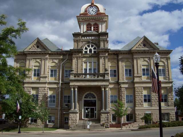
Photo: Nyttend, Wikimedia Commons, public domain · Wikimedia Commons
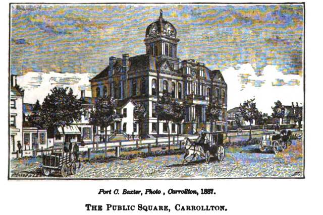
Photo: Henry Howe (1816-1893), public domain · Wikimedia Commons
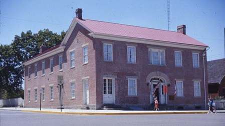
Photo: Bwsmith84, Wikimedia Commons, CC BY-SA 3.0 · Wikimedia Commons
Local history sources: en.wikipedia.org · en.wikipedia.org · ohiohistory.org · en.wikipedia.org · en.wikipedia.org · archive.org · commons.wikimedia.org
Water
Mostly private wells The water here
- Carrollton Village99% of residentsGroundwater wells (10 wells)
- Rockwood Park1% of residentsGroundwater wells (2 wells)
Hospitals, fire stations and more
Inside Center Township, Carroll County's boundary: 1 museum, 23 shale and injection wells, 1 Toxics Release Inventory facility and 3 spill cases. Press a pin or a name for its whole record and its source.
Museums, historical societies, gardens and zoos (1)
-
Carroll County Historical SocietyHistorical society · Carrollton
- What it is
- Historical society
- City
- Carrollton
- Coordinates
- 40.56789, -81.08532
Search Wikipedia ↗ IMLS Museum Data Files (source) ↗ Street map and directions ↗
The museum list is IMLS's 2018 file; a museum may have closed or moved since.
Source: IMLS Museum Data Files, 2018.
Shale and injection wells (23)
-
Burgett 7-15-6 10HUtica shale well
- What it is
- Utica shale well
- Drilled sideways
- Yes
- Operator
- Eog Ohio, Llc
- County
- Carroll County
- API well number
- 34019221370000
- Coordinates
- 40.56388, -81.12949
ODNR oil and gas wells (source) ↗ Street map and directions ↗
The point is the surface well head (the pad); a horizontal well runs a mile or more underground from it.
-
Burgett 7-15-6 1HUtica shale well
- What it is
- Utica shale well
- Drilled sideways
- Yes
- Operator
- Eog Ohio, Llc
- County
- Carroll County
- API well number
- 34019222910000
- Coordinates
- 40.56381, -81.12955
ODNR oil and gas wells (source) ↗ Street map and directions ↗
The point is the surface well head (the pad); a horizontal well runs a mile or more underground from it.
-
Burgett 7-15-6 3HUtica shale well
- What it is
- Utica shale well
- Drilled sideways
- Yes
- Operator
- Eog Ohio, Llc
- County
- Carroll County
- API well number
- 34019222920000
- Coordinates
- 40.56385, -81.12952
ODNR oil and gas wells (source) ↗ Street map and directions ↗
The point is the surface well head (the pad); a horizontal well runs a mile or more underground from it.
-
Burgett 7-15-6 5HUtica shale well
- What it is
- Utica shale well
- Drilled sideways
- Yes
- Operator
- Eog Ohio, Llc
- County
- Carroll County
- API well number
- 34019222930000
- Coordinates
- 40.56391, -81.12946
ODNR oil and gas wells (source) ↗ Street map and directions ↗
The point is the surface well head (the pad); a horizontal well runs a mile or more underground from it.
-
Burgett 7-15-6 6HUtica shale well
- What it is
- Utica shale well
- Drilled sideways
- Yes
- Operator
- Eog Ohio, Llc
- County
- Carroll County
- API well number
- 34019221100000
- Coordinates
- 40.56380, -81.12948
ODNR oil and gas wells (source) ↗ Street map and directions ↗
The point is the surface well head (the pad); a horizontal well runs a mile or more underground from it.
-
Burgett 7-15-6 8H-RsUtica shale well
- What it is
- Utica shale well
- Drilled sideways
- Yes
- Operator
- Eog Ohio, Llc
- County
- Carroll County
- API well number
- 34019220850000
- Coordinates
- 40.56395, -81.12941
ODNR oil and gas wells (source) ↗ Street map and directions ↗
The point is the surface well head (the pad); a horizontal well runs a mile or more underground from it.
-
Eckley Cr Cen 1HUtica shale well
- What it is
- Utica shale well
- Drilled sideways
- Yes
- Operator
- Eog Ohio, Llc
- County
- Carroll County
- API well number
- 34019229240000
- Coordinates
- 40.58877, -81.10630
ODNR oil and gas wells (source) ↗ Street map and directions ↗
The point is the surface well head (the pad); a horizontal well runs a mile or more underground from it.
-
Eckley Cr Cen 201HUtica shale well
- What it is
- Utica shale well
- Drilled sideways
- Yes
- Operator
- Eog Ohio, Llc
- County
- Carroll County
- API well number
- 34019229270000
- Coordinates
- 40.58872, -81.10630
ODNR oil and gas wells (source) ↗ Street map and directions ↗
The point is the surface well head (the pad); a horizontal well runs a mile or more underground from it.
-
Eckley Cr Cen 205HUtica shale well
- What it is
- Utica shale well
- Drilled sideways
- Yes
- Operator
- Eog Ohio, Llc
- County
- Carroll County
- API well number
- 34019229280000
- Coordinates
- 40.58894, -81.10630
ODNR oil and gas wells (source) ↗ Street map and directions ↗
The point is the surface well head (the pad); a horizontal well runs a mile or more underground from it.
-
Eckley Cr Cen 3HUtica shale well
- What it is
- Utica shale well
- Drilled sideways
- Yes
- Operator
- Eog Ohio, Llc
- County
- Carroll County
- API well number
- 34019229250000
- Coordinates
- 40.58883, -81.10630
ODNR oil and gas wells (source) ↗ Street map and directions ↗
The point is the surface well head (the pad); a horizontal well runs a mile or more underground from it.
-
Eckley Cr Cen 5HUtica shale well
- What it is
- Utica shale well
- Drilled sideways
- Yes
- Operator
- Eog Ohio, Llc
- County
- Carroll County
- API well number
- 34019229260000
- Coordinates
- 40.58888, -81.10630
ODNR oil and gas wells (source) ↗ Street map and directions ↗
The point is the surface well head (the pad); a horizontal well runs a mile or more underground from it.
-
Gf Farms 25-14-5 10HUtica shale well
- What it is
- Utica shale well
- Drilled sideways
- Yes
- Operator
- Eog Ohio, Llc
- County
- Carroll County
- API well number
- 34019225390000
- Coordinates
- 40.56729, -81.05825
ODNR oil and gas wells (source) ↗ Street map and directions ↗
The point is the surface well head (the pad); a horizontal well runs a mile or more underground from it.
-
Griffeth 7-15-6 1HUtica shale well
- What it is
- Utica shale well
- Drilled sideways
- Yes
- Operator
- Eog Ohio, Llc
- County
- Carroll County
- API well number
- 34019226640000
- Coordinates
- 40.57531, -81.12614
ODNR oil and gas wells (source) ↗ Street map and directions ↗
The point is the surface well head (the pad); a horizontal well runs a mile or more underground from it.
-
Griffeth 7-15-6 2HUtica shale well
- What it is
- Utica shale well
- Drilled sideways
- Yes
- Operator
- Eog Ohio, Llc
- County
- Carroll County
- API well number
- 34019226650000
- Coordinates
- 40.57530, -81.12607
ODNR oil and gas wells (source) ↗ Street map and directions ↗
The point is the surface well head (the pad); a horizontal well runs a mile or more underground from it.
-
Griffeth 7-15-6 6HUtica shale well
- What it is
- Utica shale well
- Drilled sideways
- Yes
- Operator
- Eog Ohio, Llc
- County
- Carroll County
- API well number
- 34019226660000
- Coordinates
- 40.57538, -81.12624
ODNR oil and gas wells (source) ↗ Street map and directions ↗
The point is the surface well head (the pad); a horizontal well runs a mile or more underground from it.
-
Griffeth 7-15-6 7HUtica shale well
- What it is
- Utica shale well
- Drilled sideways
- Yes
- Operator
- Eog Ohio, Llc
- County
- Carroll County
- API well number
- 34019226670000
- Coordinates
- 40.57537, -81.12617
ODNR oil and gas wells (source) ↗ Street map and directions ↗
The point is the surface well head (the pad); a horizontal well runs a mile or more underground from it.
-
Griffeth 7-15-6 8HUtica shale well
- What it is
- Utica shale well
- Drilled sideways
- Yes
- Operator
- Eog Ohio, Llc
- County
- Carroll County
- API well number
- 34019226680000
- Coordinates
- 40.57537, -81.12610
ODNR oil and gas wells (source) ↗ Street map and directions ↗
The point is the surface well head (the pad); a horizontal well runs a mile or more underground from it.
-
Griffeth 7-15-6 9HUtica shale well
- What it is
- Utica shale well
- Drilled sideways
- Yes
- Operator
- Eog Ohio, Llc
- County
- Carroll County
- API well number
- 34019226690000
- Coordinates
- 40.57537, -81.12602
ODNR oil and gas wells (source) ↗ Street map and directions ↗
The point is the surface well head (the pad); a horizontal well runs a mile or more underground from it.
-
Kovach 3-15-6 1HUtica shale well
- What it is
- Utica shale well
- Drilled sideways
- Yes
- Operator
- Eog Ohio, Llc
- County
- Carroll County
- API well number
- 34019221960100
- Coordinates
- 40.60220, -81.10335
ODNR oil and gas wells (source) ↗ Street map and directions ↗
The point is the surface well head (the pad); a horizontal well runs a mile or more underground from it.
-
Kovach 3-15-6 2HUtica shale well
- What it is
- Utica shale well
- Drilled sideways
- Yes
- Operator
- Eog Ohio, Llc
- County
- Carroll County
- API well number
- 34019228320000
- Coordinates
- 40.60219, -81.10325
ODNR oil and gas wells (source) ↗ Street map and directions ↗
The point is the surface well head (the pad); a horizontal well runs a mile or more underground from it.
-
Kovach 3-15-6 4HUtica shale well
- What it is
- Utica shale well
- Drilled sideways
- Yes
- Operator
- Eog Ohio, Llc
- County
- Carroll County
- API well number
- 34019228330000
- Coordinates
- 40.60218, -81.10317
ODNR oil and gas wells (source) ↗ Street map and directions ↗
The point is the surface well head (the pad); a horizontal well runs a mile or more underground from it.
-
Kovach 3-15-6 5HUtica shale well
- What it is
- Utica shale well
- Drilled sideways
- Yes
- Operator
- Eog Ohio, Llc
- County
- Carroll County
- API well number
- 34019228340000
- Coordinates
- 40.60217, -81.10310
ODNR oil and gas wells (source) ↗ Street map and directions ↗
The point is the surface well head (the pad); a horizontal well runs a mile or more underground from it.
-
Shaw 20-14-5 5HUtica shale well
- What it is
- Utica shale well
- Drilled sideways
- Yes
- Operator
- Eog Ohio, Llc
- County
- Carroll County
- API well number
- 34019220810100
- Coordinates
- 40.57777, -81.05283
ODNR oil and gas wells (source) ↗ Street map and directions ↗
The point is the surface well head (the pad); a horizontal well runs a mile or more underground from it.
Source: ODNR Division of Oil and Gas Resources well inventory (September 2026): drilled Utica, Marcellus and horizontal wells and Class II injection wells not plugged. Older vertical wells are on the full map.
Facilities reporting toxic releases (1)
-
Fusion Ceramics IncToxics Release Inventory · Carrollton
- Address
- 160 Scio Rd. S.E., Carrollton, OH 44615
- County
- Carroll County
- Status
- Reports to the Toxics Release Inventory (active)
- EPA program ID
- 44615FSNCR160SC
- EPA registry ID
- 110000390318
EPA facility record ↗ EPA Facility Registry Service (source) ↗ Street map and directions ↗
Source: EPA Facility Registry Service, Toxics Release Inventory reporters. Reporting a release is required of large users of listed chemicals; it is not by itself a violation.
Spills reported since 2021 (3)
-
Brine Oil And Gas Related2024-11-14 · Center Twp
- Reported
- 2024-11-14
- What spilled
- Brine Oil And Gas Related; Fuel Diesel / Diesel Fuel (Vehicle On Or Off Road)
- Largest amount reported
- 2,000 gallons
- Where
- Center Twp, Carroll County
- Ohio EPA district office
- NEDO
- Ohio EPA case number
- 2411EPA0001880
Ohio EPA spill reports (source) ↗ Street map and directions ↗
-
Bentonite / Drilling Mud Reached water2023-07-29 · Center Twp
- Reported
- 2023-07-29
- What spilled
- Bentonite / Drilling Mud
- Largest amount reported
- 200 gallons
- Reached a waterway
- Unnamed
- Where
- Center Twp, Carroll County
- Ohio EPA district office
- NEDO
- Ohio EPA case number
- 2307EPA0001291
Ohio EPA spill reports (source) ↗ Street map and directions ↗
-
Sand / Silica / Silicon Dioxide (Sio2)2026-07-09 · Center Twp
- Reported
- 2026-07-09
- What spilled
- Sand / Silica / Silicon Dioxide (Sio2); Oil Hydraulic Fluid(S); Fuel Diesel / Diesel Fuel (Vehicle On Or Off Road)
- Where
- Center Twp, Carroll County
- Ohio EPA district office
- NEDO
- Ohio EPA case number
- 2607EPA0001243
Ohio EPA spill reports (source) ↗ Street map and directions ↗
Source: Ohio EPA emergency response spill reports, 2021 to September 2026, one point per case where Ohio EPA placed it. A report is what the caller or responder recorded; amounts are often blank or estimated.
Its ZIP codes
Each ZIP code that touches Center Township, Carroll County, with the share of its residents who live here and the same headline figures as the ZIP page.
| ZIP | Share | Water | Radon | Home value | Schools | Flood |
|---|---|---|---|---|---|---|
| 44615 Carrollton | 14% | Mostly private wells | 7.9 pCi/L average radon | Median year built 1969 | Carrollton Exempted Village · 4 stars overall | 1.3% of residents in the 1% floodplain |
The county
Carroll County: 7 ZIP codes, 15 cities, villages and townships, 19,207 people.
Nearby places
Quick answers
What county is Center Township, Ohio in?
Center Township, Carroll County is a township in Carroll County, Ohio, with 1,458 residents.
When was Center Township, Ohio founded?
Center Township, Carroll County was incorporated 1836 (petitioned and organized from parts of Harrison and Washington townships). Founders on record: Carroll County commissioners, acting on a citizen petition. Source
How did Center Township, Ohio get its name?
Named for its position at the geographic center of Carroll County; petitioners in 1836 asked the county commissioners to erect a new township 'to be called Centre.' Source
What ZIP code is Center Township, Ohio?
Most of Center Township, Carroll County is in ZIP code 44615.
Where does Center Township, Ohio get its water?
The main water source for Center Township, Carroll County (Carrollton Village): Mostly private wells.
Cite this page
Cite this page as:
Cracked Buckeye, "Center Township, Carroll County", https://crackedbuckeye.com/place/center-township-carroll-county/, built 2026-10-31, accessed [date].
How to cite · Report a correction · Built 2026-10-31
