Local events in Union Township, Tuscarawas County
Nothing is posted for Union Township itself yet; here is what is on within 20 miles. All local events in Union Township, Tuscarawas County
Know a calendar we should watch? Send the link
Checked October 20; the events page is refreshed daily.
How Union Township, Tuscarawas County began
Union Township lies in the eastern part of Tuscarawas County, bordering Carroll and Harrison counties, and was organized on March 6, 1833 (together with neighboring Mill Township) out of land that had earlier belonged to the now-vanished One Leg Township, when the formation of Carroll County required the eastern townships to be reshaped. Settlement of the Little Stillwater valley began between 1808 and 1812; James Boyd, an Irish immigrant, built the Black Horse Tavern in 1819, a noted stopping place for wheat wagons hauling grain from Harrison County to the Ohio Canal. Rockford, laid out in 1816 by Nathan McGrew and Abraham Ricksecker, never prospered and by 1884 held only two or three houses. The township's southwestern corner holds part of the village of Dennison, the county's railroad town, while its northwestern corner touches the small community of Roswell; otherwise it is farm country with scattered rural schools, one of which -- the former Roxford District School -- now operates as a winery. It covers 22.2 square miles and had 1,449 residents at the 2020 census.
Settled 1808-1812 (Little Stillwater valley), incorporated 1833-03-06, by organized March 6, 1833, from territory formerly part of One Leg Township, when Carroll County's formation required the eastern Tuscarawas townships to be re-shaped.
Where the name comes from
"Union" is one of the most common township names in Ohio; the state has twenty-seven Union Townships, and no source consulted here gives a founding-specific reason for the choice in Tuscarawas County.
Before the town
No Native American village, trail, or archaeological site specific to Union Township itself is documented in the sources consulted. The township lies within the Tuscarawas River watershed that was Delaware (Lenape) country in the 18th century and was ceded to the United States by the Treaty of Greenville (1795). The wider valley's documented Moravian mission towns, Fort Laurens, and treaty history are not placed inside Union Township's own boundaries by any source found here.
Timeline
- — The Little Stillwater valley becomes the first-settled part of the township; John McPherson, William McCleary, David Wagoner, James Vanater, George Kail, Jacob Creager, Solomon Arnold and James Boyd (an Irish immigrant from County Tyrone) are among the earliest arrivals.
- — Nathan McGrew and Abraham Ricksecker lay out Rockford, forty-two lots, on the southeast quarter of Section 36; neither proprietor ever lives there, and a supposed defect in the title deters settlers, so the village never prospers.
- — James Boyd builds the Black Horse Tavern on the southwest quarter of Section 26, at a road junction; it becomes a noted stopping place for teams hauling wheat from Harrison County to the Ohio Canal, with a dozen wagons in the yard a common sight.
- — Union Township is organized on March 6, along with Mill Township, from territory reshaped after Carroll County's formation; for the first five years elections are held at George Rutledge's house, then move permanently to William Brock's residence.
- — The Langdon Mill is built in the southeast corner of the township and is, for a time, the only mill within a radius of many miles.
- — The Dennison Land Company lays out the village of Dennison, whose southwestern portion falls within Union Township (the rest lies in Mill Township).
- — Dennison incorporates as a village, named for Ohio governor William Dennison.
Stories
A school becomes a winery
Like many rural Ohio townships, Union Township once ran a network of small district schools serving the farms scattered across its 22 square miles. One of them, the Roxford District School, has survived past its original purpose: the building now operates as Casella Winery, an example of the adaptive reuse that has kept a number of the county's one-room and small township schools standing long after consolidation ended their use as classrooms.
Free whisky wins the first election
The 1884 county history records that at Union Township's very first election for Justice of the Peace, the two candidates who kept taverns, James Boyd and James Gray, ran against George Graham and John Iler, both members of the Methodist Church who opposed the free flow of liquor at public gatherings. Boyd and Gray opened a keg of "free whisky" at the polls and carried the election. The temperance element soon rallied, however, and took control of the township for good; men including Joshua Leggett, Thomas Milligan, William Rutledge and Reese Baldwin later led the effort that ended the practice of serving liquor at barn-raisings and other public gatherings altogether.
Rockford: the town that never was
In 1816 Nathan McGrew and Abraham Ricksecker surveyed forty-two lots on the Little Stillwater and called the place Rockford. Neither man ever lived there, and word that the title to the land was questionable kept most settlers away; at its largest the village may have held six dwellings. A post office operated there for a time under Thomas Furby, and a handful of merchants, a doctor and tavern keepers came and went over the decades, but by 1884 only two or three houses remained on a site that once had a full town plat on paper.
Photographs
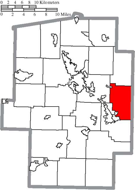
Photo: Ruhrfisch and Nyttend, Wikimedia Commons, CC BY-SA 3.0 · Wikimedia Commons
Local history sources: en.wikipedia.org · en.wikipedia.org · archive.org · commons.wikimedia.org
Water
Tuscarawas River valley aquifer (local wells) The water here
- Twin City Water and Sewer District83% of residentsTuscarawas River valley aquifer (local wells)
- New Philadelphia City14% of residentsTuscarawas River valley sand-and-gravel aquifer (wells)
- Aqua Ohio - Midvale2% of residentsGroundwater wells (3 wells)
- Fohl Village MHP1% of residentsGroundwater wells (2 wells)
- Tcmsd-wainwright0% of residentsGroundwater wells (2 wells)
- Tuscarawas Village0% of residentsGroundwater wells (2 wells)
- Dover City0% of residentsSugar Creek Basin sand-and-gravel aquifer (Dover wellfield)
Hospitals, fire stations and more
Inside Union Township, Tuscarawas County's boundary: 1 poor-rated bridge, 3 shale and injection wells and 4 spill cases. Press a pin or a name for its whole record and its source.
Bridges rated poor (1)
-
US 250 over Br Little Stillwater CrPoor · built 1985
- Condition
- Poor: a deck, superstructure, substructure or culvert rated 4 or below on the 0 to 9 scale
- What it is
- Bridge
- Built
- 1985
- Length
- 13 ft
- Owner
- State
- Vehicles a day
- 9,264
- Coordinates
- 40.40341, -81.32107
National Bridge Inventory (source) ↗ Street map and directions ↗
Source: FHWA National Bridge Inventory 2025. "Poor" means one major part rated 4 or below on the 0 to 9 scale; it calls for repair, not closing, unless the state posts or closes the bridge.
Shale and injection wells (3)
-
Dennison Disposal (Swiw #11) 1 InjectionInjection well (Class II)
- What it is
- Injection well (Class II)
- Operator
- Dennison Disposal Llc
- County
- Tuscarawas County
- API well number
- 34157255070000
- Coordinates
- 40.40760, -81.31154
ODNR oil and gas wells (source) ↗ Street map and directions ↗
-
Dennison Disposal (Swiw#15) 2 InjectionInjection well (Class II)
- What it is
- Injection well (Class II)
- Operator
- Dennison Disposal Llc
- County
- Tuscarawas County
- API well number
- 34157255210000
- Coordinates
- 40.40702, -81.31589
ODNR oil and gas wells (source) ↗ Street map and directions ↗
-
Re-Hydro (Swiw #10) 1 InjectionInjection well (Class II)
- What it is
- Injection well (Class II)
- Operator
- Mason Drilling Inc
- County
- Tuscarawas County
- API well number
- 34157255060000
- Coordinates
- 40.40842, -81.29536
ODNR oil and gas wells (source) ↗ Street map and directions ↗
Source: ODNR Division of Oil and Gas Resources well inventory (September 2026): drilled Utica, Marcellus and horizontal wells and Class II injection wells not plugged. Older vertical wells are on the full map.
Spills reported since 2021 (4)
-
Fuel Diesel / Diesel Fuel (Vehicle On Or Off Road)2024-01-02 · Union Twp
- Reported
- 2024-01-02
- What spilled
- Fuel Diesel / Diesel Fuel (Vehicle On Or Off Road)
- Where
- Union Twp, Tuscarawas County
- Ohio EPA district office
- SEDO
- Ohio EPA case number
- 2401EPA0000007
Ohio EPA spill reports (source) ↗ Street map and directions ↗
-
Bentonite / Drilling Mud Reached water2023-12-07 · Union Twp
- Reported
- 2023-12-07
- What spilled
- Bentonite / Drilling Mud
- Largest amount reported
- 5 gallons
- Reached a waterway
- 99 - Unnamed
- Where
- Union Twp, Tuscarawas County
- Ohio EPA district office
- SEDO
- Ohio EPA case number
- 2312EPA0002029
Ohio EPA spill reports (source) ↗ Street map and directions ↗
-
Brine De-Icing Road Use2022-02-12 · Union Twp
- Reported
- 2022-02-12
- What spilled
- Brine De-Icing Road Use
- Largest amount reported
- 4,000 gallons
- Where
- Union Twp, Tuscarawas County
- Ohio EPA district office
- SEDO
- Ohio EPA case number
- 2202EPA0000167
Ohio EPA spill reports (source) ↗ Street map and directions ↗
-
Material Unknown Reached water2026-08-12 · Union Twp
- Reported
- 2026-08-12
- What spilled
- Material Unknown
- Reached a waterway
- 79 - Stillwater Creek
- Where
- Union Twp, Tuscarawas County
- Ohio EPA district office
- SEDO
- Ohio EPA case number
- 2608EPA0001482
Ohio EPA spill reports (source) ↗ Street map and directions ↗
Source: Ohio EPA emergency response spill reports, 2021 to September 2026, one point per case where Ohio EPA placed it. A report is what the caller or responder recorded; amounts are often blank or estimated.
Its ZIP codes
Each ZIP code that touches Union Township, Tuscarawas County, with the share of its residents who live here and the same headline figures as the ZIP page.
| ZIP | Share | Water | Radon | Home value | Schools | Flood |
|---|---|---|---|---|---|---|
| 44621 Dennison | 20% | Tuscarawas River valley aquifer (local wells) | 7.1 pCi/L average radon | Median year built 1940 | Claymont City · 3 stars overall | 5.2% of residents in the 1% floodplain |
| 44675 Monroe Township and Sherrodsville | 6% | Mostly private wells | 10.7 pCi/L average radon | Median year built 1974 | Conotton Valley Union Local · 4.5 stars overall | 3.8% of residents in the 1% floodplain |
| 44663 New Philadelphia | 1% | Wells in the sand-and-gravel aquifer within the Tuscarawas River valley near New Philadelphia | 5.3 pCi/L average radon | Median year built 1956 | New Philadelphia City · 3 stars overall | 5.2% of residents in the 1% floodplain |
Local government
Who holds office in Union Township, Tuscarawas County, how its elections and ballot issues came out, and the state auditor's record.
Ballot issues
| Date | Issue | For | Against | Result |
|---|---|---|---|---|
| 2019-11-05 | Issue: Casella LLC D6 074 Union Twp | 172 | 62 | Passed (73.5% for) |
Elections for office
| Date | Office | Candidates and votes |
|---|---|---|
| 2019-11-05 | Township Trustee | Joe Martinelli 214, 100.0% |
| 2019-11-05 | Township Fiscal Officer | Debbie Lukens 214, 100.0% |
Winners in bold. Results from the county board of elections' official canvass unless marked.
Auditor of State record
- No fiscal caution, watch or emergency on the Auditor of State's lists.
- Agreed Upon Procedures, 2024 to 2025, released 2026-05-07
The county
Tuscarawas County: 17 ZIP codes, 40 cities, villages and townships, 92,903 people.
Nearby places
Quick answers
What county is Union Township, Ohio in?
Union Township, Tuscarawas County is a township in Tuscarawas County, Ohio, with 1,190 residents.
When was Union Township, Ohio founded?
Union Township, Tuscarawas County was settled 1808-1812 (Little Stillwater valley); incorporated 1833-03-06. Founders on record: organized March 6, 1833, from territory formerly part of One Leg Township, when Carroll County's formation required the eastern Tuscarawas townships to be re-shaped. Source
How did Union Township, Ohio get its name?
"Union" is one of the most common township names in Ohio; the state has twenty-seven Union Townships, and no source consulted here gives a founding-specific reason for the choice in Tuscarawas County. Source
What ZIP code is Union Township, Ohio?
Union Township, Tuscarawas County is served by ZIP codes 44621 and 44675; 44621 holds the largest share of its residents.
Where does Union Township, Ohio get its water?
The main water source for Union Township, Tuscarawas County (Twin City Water and Sewer District): Tuscarawas River valley aquifer (local wells).
Cite this page
Cite this page as:
Cracked Buckeye, "Union Township, Tuscarawas County", https://crackedbuckeye.com/place/union-township-tuscarawas-county/, built 2026-10-31, accessed [date].
How to cite · Report a correction · Built 2026-10-31
