Local events in Rose Township, Carroll County
Nothing is posted for Rose Township itself yet; here is what is on within 20 miles. All local events in Rose Township, Carroll County
Know a calendar we should watch? Send the link
Checked October 20; the events page is refreshed daily.
How Rose Township, Carroll County began
Rose Township was organized in 1818 out of Sandy Township, Stark County, fourteen years before Carroll County itself was created, and was named simply for the wild roses that grew across it. It sits in the western part of the county at the meeting point of Carroll, Stark and Tuscarawas counties, where a 1786 government survey marker — the Seven Ranges Terminus — still stands. The unincorporated hamlet of Morges, platted in 1831, grew around one of the area's earliest Catholic congregations. Today it is a farming township of decoratively painted barns and about 1,168 people outside its small crossroads communities.
Incorporated 1818, by Carved from Sandy Township, Stark County, by county commissioners.
Where the name comes from
Rose Township was named for the many wild roses growing in the area; it is the only Rose Township in Ohio.
Before the town
No Native American village, trail or mound is recorded as sitting inside Rose Township's own boundaries in the sources checked. The township's land was part of the roughly two-thirds of Ohio that the Delaware (Lenape) and Wyandot ceded to the United States by the Treaty of Fort McIntosh in January 1785, decades before any township lines were drawn here; American settlement of Carroll County followed the Treaty of Greenville (1795) and continued Delaware removal westward. The Great Trail, an Algonquian and Iroquoian trade path linking the forks of the Ohio to Lake Erie, crossed Carroll County through Brown Township and Malvern, and elderly Delaware and Mingo families were still remembered locally around that route into the early 1800s. Nothing more specific to Rose Township itself was found.
Nations recorded here: Lenape (Delaware), Mingo (Seneca-Cayuga), Wyandot.
Timeline
- — The Geographer's Line survey of the Seven Ranges was completed at a point on Rose Township's north boundary, near the junction of Carroll, Stark and Tuscarawas counties — the first rectangular land survey in the United States.
- — Rose Township was set off from Sandy Township, Stark County.
- — Mathias Little built a cabin in the Morges area that hosted the first Catholic Mass said in the vicinity.
- — Samuel Oswalt and John Waggoner platted the village of Morges.
- — The present St. Mary of the Immaculate Conception church at Morges was built of brick burned on the premises.
- — The Seven Ranges Terminus marker was added to the National Register of Historic Places.
- — St. Mary's of Morges was added to the National Register of Historic Places.
Stories
The corner where the surveying ended
In 1785 Congress ordered the land northwest of the Ohio River divided into a grid of six-mile-square townships before any of it could be sold, and surveyors under Thomas Hutchins started the job at the point where the Ohio River crosses the Pennsylvania line. A year of chain-and-compass work later, on August 10, 1786, the survey of the first seven ranges of townships was finished at a spot that is now the north boundary of Rose Township, where Carroll, Stark and Tuscarawas counties meet. A small granite post, six inches square with an X cut in its top and only about a foot showing above ground, still marks the corner of four townships and three counties. It looks like nothing from the road, but it marks the west end of the first line run under the rectangular survey plan later used for nearly all western lands.
A frontier parish built of its own brick
Catholic settlers were gathering in the Morges neighborhood by 1823, when Mathias Little's log cabin hosted the first Mass said in the area. The village of Morges itself was platted in 1831 by Samuel Oswalt and John Waggoner, and by 1851 the congregation was substantial enough to build a permanent brick church — bricks burned right on the property rather than hauled in. St. Mary of the Immaculate Conception still stands at 8012 Bachelor Road, one of the older continuously used Catholic church buildings in this part of eastern Ohio, and was added to the National Register of Historic Places in 1977.
Photographs
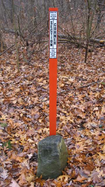
Photo: Nyttend, public domain · Wikimedia Commons
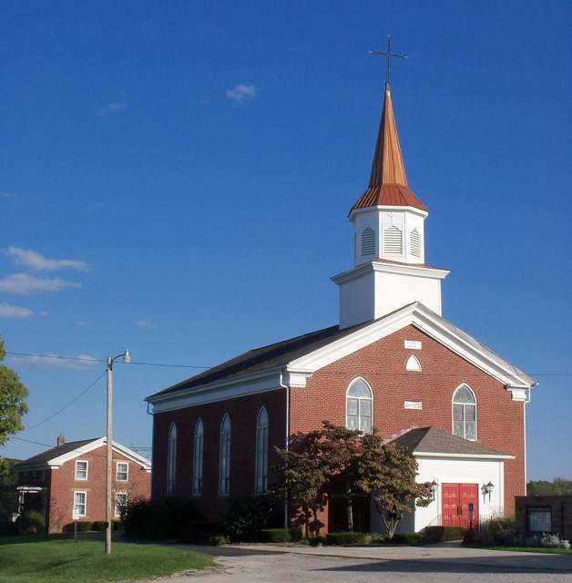
Photo: Roseohioresident, via Wikimedia Commons, CC0 · Wikimedia Commons
Local history sources: en.wikipedia.org · en.wikipedia.org · en.wikipedia.org · en.wikipedia.org · en.wikipedia.org · en.wikipedia.org · en.wikipedia.org · en.wikipedia.org · en.wikipedia.org
Historic places
1 place in Rose Township, Carroll County on the National Register of Historic Places. Press a pin or a name for its whole record.
-
St. Mary's Of MorgesBuilding · Waynesburg · listed 1977
- Address
- 8012 Bachelor Rd., NW.
- Where
- Waynesburg, Carroll County · ZIP 44688
- What it is
- Building
- Listed on the National Register
- 1977
- NRIS reference number
- 77001047
- Coordinates
- 40.63446, -81.24236
National Register file (NPS) ↗ Search Wikipedia ↗ Street map and directions ↗ On the Cracked Buckeye map
Source: National Park Service, National Register of Historic Places point file. The listing year is shown where NPS's certification date agrees with the listing's reference number. Listing recognizes significance; it does not restrict a private owner.
Water
Mostly private wells The water here
- Magnolia Village45% of residentsGroundwater wells (3 wells)
- Fohl Village MHP28% of residentsGroundwater wells (2 wells)
- Waynesburg Village23% of residentsGroundwater wells (2 wells)
- East Sparta Village2% of residentsGroundwater wells (4 wells)
- Bolivar Village2% of residentsGroundwater wells (2 wells)
Hospitals, fire stations and more
Inside Rose Township, Carroll County's boundary: 1 poor-rated bridge, 5 shale and injection wells and 2 spill cases. Press a pin or a name for its whole record and its source.
Bridges rated poor (1)
-
Rose Twp Rd 180 over Big Sandy Br Rrarch Bn35Poor · built 1910
- Condition
- Poor: a deck, superstructure, substructure or culvert rated 4 or below on the 0 to 9 scale
- What it is
- Culvert
- Built
- 1910
- Length
- 9 ft
- Owner
- County
- Vehicles a day
- 209
- Coordinates
- 40.63541, -81.30492
National Bridge Inventory (source) ↗ Street map and directions ↗
Source: FHWA National Bridge Inventory 2025. "Poor" means one major part rated 4 or below on the 0 to 9 scale; it calls for repair, not closing, unless the state posts or closes the bridge.
Shale and injection wells (5)
-
Lindentree(Swiw#7) 6 InjectionInjection well (Class II)
- What it is
- Injection well (Class II)
- Operator
- Ows Acquisition Co Llc
- County
- Carroll County
- API well number
- 34019203250000
- Coordinates
- 40.60354, -81.26600
ODNR oil and gas wells (source) ↗ Street map and directions ↗
-
Lindentree(Swiw#8) 7 InjectionInjection well (Class II)
- What it is
- Injection well (Class II)
- Operator
- Ows Acquisition Co Llc
- County
- Carroll County
- API well number
- 34019203260000
- Coordinates
- 40.60701, -81.26498
ODNR oil and gas wells (source) ↗ Street map and directions ↗
-
Ott 13-16-7 10HUtica shale well
- What it is
- Utica shale well
- Drilled sideways
- Yes
- Operator
- Eog Ohio, Llc
- County
- Carroll County
- API well number
- 34019220940000
- Coordinates
- 40.57105, -81.25244
ODNR oil and gas wells (source) ↗ Street map and directions ↗
The point is the surface well head (the pad); a horizontal well runs a mile or more underground from it.
-
Rose 0801 1HHorizontal shale well
- What it is
- Horizontal shale well
- Drilled sideways
- Yes
- Operator
- Eog Resources Inc.
- County
- Carroll County
- API well number
- 34019227880100
- Coordinates
- 40.59099, -81.23272
ODNR oil and gas wells (source) ↗ Street map and directions ↗
The point is the surface well head (the pad); a horizontal well runs a mile or more underground from it.
-
Rose 0816 2HHorizontal shale well
- What it is
- Horizontal shale well
- Drilled sideways
- Yes
- Operator
- Eog Resources Inc.
- County
- Carroll County
- API well number
- 34019228010000
- Coordinates
- 40.59051, -81.23275
ODNR oil and gas wells (source) ↗ Street map and directions ↗
The point is the surface well head (the pad); a horizontal well runs a mile or more underground from it.
Source: ODNR Division of Oil and Gas Resources well inventory (September 2026): drilled Utica, Marcellus and horizontal wells and Class II injection wells not plugged. Older vertical wells are on the full map.
Spills reported since 2021 (2)
-
Oil Crude2022-03-16 · Rose Twp
- Reported
- 2022-03-16
- What spilled
- Oil Crude
- Where
- Rose Twp, Carroll County
- Ohio EPA district office
- NEDO
- Ohio EPA case number
- 2203EPA0000343
Ohio EPA spill reports (source) ↗ Street map and directions ↗
-
Material Unknown2022-01-07 · Rose Twp
- Reported
- 2022-01-07
- What spilled
- Material Unknown
- Where
- Rose Twp, Carroll County
- Ohio EPA district office
- NEDO
- Ohio EPA case number
- 2201EPA0000023
Ohio EPA spill reports (source) ↗ Street map and directions ↗
Source: Ohio EPA emergency response spill reports, 2021 to September 2026, one point per case where Ohio EPA placed it. A report is what the caller or responder recorded; amounts are often blank or estimated.
Its ZIP codes
Each ZIP code that touches Rose Township, Carroll County, with the share of its residents who live here and the same headline figures as the ZIP page.
| ZIP | Share | Water | Radon | Home value | Schools | Flood |
|---|---|---|---|---|---|---|
| 44620 Rose Township and Dellroy | 32% | Mostly private wells | 11.5 pCi/L average radon | Median year built 1978 | Carrollton Exempted Village · 4 stars overall | 2.9% of residents in the 1% floodplain |
| 44643 Magnolia | 13% | Mostly private wells | 11.0 pCi/L average radon | Median year built 1961 | Sandy Valley Local · 3 stars overall | 4.1% of residents in the 1% floodplain |
| 44688 Sandy Township and Waynesburg | 7% | Mostly private wells | 8.1 pCi/L average radon | Median year built 1953 | Sandy Valley Local · 3 stars overall | 12% of residents in the 1% floodplain |
| 44656 Sandy Township and Mineral City | 4% | Mostly private wells | 6.5 pCi/L average radon | Median year built 1961 | Tuscarawas Valley Local · 4 stars overall | 7.8% of residents in the 1% floodplain |
The county
Stark County: 34 ZIP codes, 36 cities, villages and townships, 374,115 people.
Nearby places
Quick answers
What county is Rose Township, Ohio in?
Rose Township, Carroll County is a township in Stark County, Ohio, with 1,168 residents.
When was Rose Township, Ohio founded?
Rose Township, Carroll County was incorporated 1818. Founders on record: Carved from Sandy Township, Stark County, by county commissioners. Source
How did Rose Township, Ohio get its name?
Rose Township was named for the many wild roses growing in the area; it is the only Rose Township in Ohio. Source
What ZIP code is Rose Township, Ohio?
Rose Township, Carroll County is served by ZIP codes 44620, 44643, 44688 and 44656; 44620 holds the largest share of its residents.
Where does Rose Township, Ohio get its water?
The main water source for Rose Township, Carroll County (Magnolia Village): Mostly private wells.
Cite this page
Cite this page as:
Cracked Buckeye, "Rose Township, Carroll County", https://crackedbuckeye.com/place/rose-township-carroll-county/, built 2026-10-31, accessed [date].
How to cite · Report a correction · Built 2026-10-31
