Local events in Harrison Township, Carroll County
Nothing is posted for Harrison Township itself yet; here is what is on within 20 miles. All local events in Harrison Township, Carroll County
Know a calendar we should watch? Send the link
Checked October 20; the events page is refreshed daily.
How Harrison Township, Carroll County began
Harrison Township, in west-central Carroll County, was formed in 1817 out of Sandy Township while the area still belonged to Stark County, and lost part of its original territory later when Center Township was split off. Its one historic settlement, New Harrisburg, was platted in 1828 along the Steubenville-Canton stagecoach line and briefly competed to become the county seat before railroads bypassed it and it faded to little more than a crossroads. A stretch of the Underground Railroad reportedly ran through the township along Baxter Ridge. Today the township has no incorporated village of its own; its north edge holds part of the Lake Mohawk gated community shared with Brown Township, and most residents are served by Carrollton.
Incorporated 1817 (organized from Sandy Township, then part of Stark County).
Where the name comes from
One of nineteen Harrison Townships across Ohio; sources reviewed did not specify whether it honors William Henry Harrison specifically, but the naming fits the common Ohio pattern of townships named for the future president/War of 1812 general in the decades after his Ohio campaigns.
Before the town
No source reviewed records a Native American village, mound or documented encounter specific to Harrison Township. The township was carved from Stark County territory that, like the rest of Carroll County, was opened to settlement only after the Lenape (Delaware), Wyandot and allied nations ceded their claims under the Treaty of Greenville (1795) and later treaties; the Great Trail, the region's major indigenous travel corridor, passed through Carroll County generally though no source ties it to a specific point within this township.
Nations recorded here: Lenape (Delaware), Wyandot.
Timeline
- — Harrison Township is organized out of Sandy Township, at that time part of Stark County.
- — The township has 518 people, rising to 1,308 in 1840; the later census counts are 915 in 1890, 799 in 1900 and 750 in 1910.
- — Jacob Harsh plats the village of New Harrisburg on December 26 along the Steubenville-Canton stagecoach road established by Bezaleel Wells.
- — The Underground Railroad's route from Port Washington through Leesville to Salem crosses the township along Baxter's Ridge; Joseph S. Burr and Jacob Millesack are the conductors named, and Carrollton is avoided as unsafe.
- — A local merchant offers ten acres to relocate the Carroll County seat to New Harrisburg when a new courthouse is being planned; the effort fails and the county seat stays at Carrollton.
- — Township voters approve selling the school section lands (120 to 35) that had funded local schools since before 1882.
- — New Harrisburg has about 200 people, a postmaster (James Barr), dry-goods store, tannery, hotel and undertaker; Colonel Ayers offers the county ten acres for a county seat there.
- — The Wheeling & Lake Erie line serves the township only through way-stations at Hibbetts and, just over the line, Stemple; the old Conotton Valley Railroad had passed about three miles from New Harrisburg and left it off the line.
- — Lake Mohawk, a 507-acre reservoir and gated community built by American Realty Service Corporation, is created on Middle Run, with its northern edge in Harrison Township.
- — The population is 1,807, up from 711 in 1920; it peaks at 2,498 in 2000 and is 2,397 in 2020.
Stories
The stagecoach town the railroad passed by
Jacob Harsh platted New Harrisburg at the end of 1828 along the well-traveled Steubenville-to-Canton stage line, and for decades it functioned as a working stage stop with its own tavern, a distillery and pottery on the nearby Jacob Rock farm, and by the 1880s two churches and roughly 200 residents. Its fortunes turned on a matter of three miles: when the Connotton Valley Railroad was built through the township, its route missed New Harrisburg, and the town that had grown on wagon and coach traffic had no way to compete with rail towns nearby. By 1920 a county historian could write that the place held 'nothing to note a commercial interest ... it only remains a memory of the older citizens of the county.'
A bishop from a fading crossroads
The township's most notable native son was the Reverend Jonathan Weaver, born in Harrison Township on February 23, 1824, who served Otterbein College for eight years as its trustees' soliciting agent and in 1865 was chosen a bishop of the United Brethren Church. His career is a reminder that this farming township, and the small stagecoach town of New Harrisburg at its heart, produced people of regional and denominational importance well beyond Carroll County's borders.
The ridge road to freedom
Harrison Township lay on one of the Underground Railroad routes through Carroll County. The 1921 county history describes it: from Port Washington in Tuscarawas County the line ran through Leesville, then to Salem in Columbiana County by way of Baxter's Ridge in Harrison Township, and on by Judge George's place in Fox Township. The conductors named are Joseph S. Burr and Jacob Millesack. Carrollton was avoided if at all possible, because it was not considered a safe place to hide a fugitive. Wikipedia likewise notes that an Underground Railroad route passed through Harrison Township along Baxter Ridge. The history adds that Baxter's Ridge was counted the finest farm land in the township, and that on the same road, in the township's northeast, lay what was called the Swamp.
Photographs
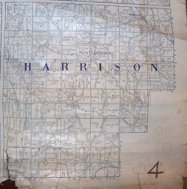
Photo: R.H. Lee / Lee's Farm Atlas of Carroll County, Ohio (C.H. Chadwick, Ann Arbor), public domain · Wikimedia Commons
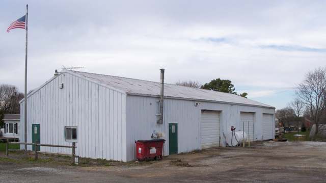
Photo: Roseohioresident, Wikimedia Commons, CC BY-SA 4.0 · Wikimedia Commons
Local history sources: en.wikipedia.org · ohiogenealogyexpress.com · en.wikipedia.org · en.wikipedia.org · en.wikipedia.org · archive.org · en.wikipedia.org
Water
Mostly private wells The water here
- Carrollton Village72% of residentsGroundwater wells (10 wells)
- Aqua Ohio - Mohawk10% of residentsGroundwater wells (8 wells)
- Fohl Village MHP9% of residentsGroundwater wells (2 wells)
- Malvern Village8% of residentsGroundwater wells (2 wells)
- Rockwood Park1% of residentsGroundwater wells (2 wells)
- Green Acres Mobile Estates1% of residentsGroundwater wells (2 wells)
Hospitals, fire stations and more
Inside Harrison Township, Carroll County's boundary: 24 shale and injection wells and 6 spill cases. Press a pin or a name for its whole record and its source.
Shale and injection wells (24)
-
Cairns 5HUtica shale well
- What it is
- Utica shale well
- Drilled sideways
- Yes
- Operator
- Eog Resources Inc.
- County
- Carroll County
- API well number
- 34019220930000
- Coordinates
- 40.61045, -81.18795
ODNR oil and gas wells (source) ↗ Street map and directions ↗
The point is the surface well head (the pad); a horizontal well runs a mile or more underground from it.
-
Folsam Cr Har 1HUtica shale well
- What it is
- Utica shale well
- Drilled sideways
- Yes
- Operator
- Eog Ohio, Llc
- County
- Carroll County
- API well number
- 34019228870000
- Coordinates
- 40.57371, -81.13956
ODNR oil and gas wells (source) ↗ Street map and directions ↗
The point is the surface well head (the pad); a horizontal well runs a mile or more underground from it.
-
Folsam Cr Har 205HUtica shale well
- What it is
- Utica shale well
- Drilled sideways
- Yes
- Operator
- Eog Ohio, Llc
- County
- Carroll County
- API well number
- 34019228900000
- Coordinates
- 40.57370, -81.13934
ODNR oil and gas wells (source) ↗ Street map and directions ↗
The point is the surface well head (the pad); a horizontal well runs a mile or more underground from it.
-
Folsam Cr Har 3HUtica shale well
- What it is
- Utica shale well
- Drilled sideways
- Yes
- Operator
- Eog Ohio, Llc
- County
- Carroll County
- API well number
- 34019228880000
- Coordinates
- 40.57371, -81.13949
ODNR oil and gas wells (source) ↗ Street map and directions ↗
The point is the surface well head (the pad); a horizontal well runs a mile or more underground from it.
-
Folsam Cr Har 5HUtica shale well
- What it is
- Utica shale well
- Drilled sideways
- Yes
- Operator
- Eog Ohio, Llc
- County
- Carroll County
- API well number
- 34019228890000
- Coordinates
- 40.57370, -81.13942
ODNR oil and gas wells (source) ↗ Street map and directions ↗
The point is the surface well head (the pad); a horizontal well runs a mile or more underground from it.
-
Goebeler 10HHorizontal shale well
- What it is
- Horizontal shale well
- Drilled sideways
- Yes
- Operator
- Inr Ohio Llc
- County
- Carroll County
- API well number
- 34019227990000
- Coordinates
- 40.64514, -81.09767
ODNR oil and gas wells (source) ↗ Street map and directions ↗
The point is the surface well head (the pad); a horizontal well runs a mile or more underground from it.
-
Goebeler 4HHorizontal shale well
- What it is
- Horizontal shale well
- Drilled sideways
- Yes
- Operator
- Inr Ohio Llc
- County
- Carroll County
- API well number
- 34019227980000
- Coordinates
- 40.64514, -81.09776
ODNR oil and gas wells (source) ↗ Street map and directions ↗
The point is the surface well head (the pad); a horizontal well runs a mile or more underground from it.
-
Goebeler Unit 11HUtica shale well
- What it is
- Utica shale well
- Drilled sideways
- Yes
- Operator
- Inr Ohio Llc
- County
- Carroll County
- API well number
- 34019227420000
- Coordinates
- 40.64536, -81.09759
ODNR oil and gas wells (source) ↗ Street map and directions ↗
The point is the surface well head (the pad); a horizontal well runs a mile or more underground from it.
-
Goebeler Unit 13HUtica shale well
- What it is
- Utica shale well
- Drilled sideways
- Yes
- Operator
- Inr Ohio Llc
- County
- Carroll County
- API well number
- 34019227410000
- Coordinates
- 40.64531, -81.09759
ODNR oil and gas wells (source) ↗ Street map and directions ↗
The point is the surface well head (the pad); a horizontal well runs a mile or more underground from it.
-
Goebeler Unit 1HUtica shale well
- What it is
- Utica shale well
- Drilled sideways
- Yes
- Operator
- Inr Ohio Llc
- County
- Carroll County
- API well number
- 34019226910000
- Coordinates
- 40.64392, -81.09802
ODNR oil and gas wells (source) ↗ Street map and directions ↗
The point is the surface well head (the pad); a horizontal well runs a mile or more underground from it.
-
Goebeler Unit 2HUtica shale well
- What it is
- Utica shale well
- Drilled sideways
- Yes
- Operator
- Inr Ohio Llc
- County
- Carroll County
- API well number
- 34019226180000
- Coordinates
- 40.64404, -81.09801
ODNR oil and gas wells (source) ↗ Street map and directions ↗
The point is the surface well head (the pad); a horizontal well runs a mile or more underground from it.
-
Goebeler Unit 3HUtica shale well
- What it is
- Utica shale well
- Drilled sideways
- Yes
- Operator
- Inr Ohio Llc
- County
- Carroll County
- API well number
- 34019226920000
- Coordinates
- 40.64396, -81.09802
ODNR oil and gas wells (source) ↗ Street map and directions ↗
The point is the surface well head (the pad); a horizontal well runs a mile or more underground from it.
-
Goebeler Unit 5HUtica shale well
- What it is
- Utica shale well
- Drilled sideways
- Yes
- Operator
- Inr Ohio Llc
- County
- Carroll County
- API well number
- 34019227400000
- Coordinates
- 40.64544, -81.09766
ODNR oil and gas wells (source) ↗ Street map and directions ↗
The point is the surface well head (the pad); a horizontal well runs a mile or more underground from it.
-
Goebeler Unit 6HUtica shale well
- What it is
- Utica shale well
- Drilled sideways
- Yes
- Operator
- Inr Ohio Llc
- County
- Carroll County
- API well number
- 34019227380000
- Coordinates
- 40.64547, -81.09759
ODNR oil and gas wells (source) ↗ Street map and directions ↗
The point is the surface well head (the pad); a horizontal well runs a mile or more underground from it.
-
Goebeler Unit 7HUtica shale well
- What it is
- Utica shale well
- Drilled sideways
- Yes
- Operator
- Inr Ohio Llc
- County
- Carroll County
- API well number
- 34019227390000
- Coordinates
- 40.64539, -81.09766
ODNR oil and gas wells (source) ↗ Street map and directions ↗
The point is the surface well head (the pad); a horizontal well runs a mile or more underground from it.
-
Goebeler Unit 8HUtica shale well
- What it is
- Utica shale well
- Drilled sideways
- Yes
- Operator
- Inr Ohio Llc
- County
- Carroll County
- API well number
- 34019227370000
- Coordinates
- 40.64541, -81.09759
ODNR oil and gas wells (source) ↗ Street map and directions ↗
The point is the surface well head (the pad); a horizontal well runs a mile or more underground from it.
-
Goebeler Unit 9HUtica shale well
- What it is
- Utica shale well
- Drilled sideways
- Yes
- Operator
- Inr Ohio Llc
- County
- Carroll County
- API well number
- 34019227430000
- Coordinates
- 40.64533, -81.09767
ODNR oil and gas wells (source) ↗ Street map and directions ↗
The point is the surface well head (the pad); a horizontal well runs a mile or more underground from it.
-
Morsheiser 26-15-6 10HUtica shale well
- What it is
- Utica shale well
- Drilled sideways
- Yes
- Operator
- Eog Ohio, Llc
- County
- Carroll County
- API well number
- 34019221780000
- Coordinates
- 40.57917, -81.17687
ODNR oil and gas wells (source) ↗ Street map and directions ↗
The point is the surface well head (the pad); a horizontal well runs a mile or more underground from it.
-
Morsheiser 26-15-6 5HUtica shale well
- What it is
- Utica shale well
- Drilled sideways
- Yes
- Operator
- Eog Ohio, Llc
- County
- Carroll County
- API well number
- 34019222240000
- Coordinates
- 40.57923, -81.17683
ODNR oil and gas wells (source) ↗ Street map and directions ↗
The point is the surface well head (the pad); a horizontal well runs a mile or more underground from it.
-
Perry 3HUtica shale well
- What it is
- Utica shale well
- Drilled sideways
- Yes
- Operator
- Inr Ohio Llc
- County
- Carroll County
- API well number
- 34019227820000
- Coordinates
- 40.63708, -81.11867
ODNR oil and gas wells (source) ↗ Street map and directions ↗
The point is the surface well head (the pad); a horizontal well runs a mile or more underground from it.
-
Perry 4HUtica shale well
- What it is
- Utica shale well
- Drilled sideways
- Yes
- Operator
- Inr Ohio Llc
- County
- Carroll County
- API well number
- 34019227830000
- Coordinates
- 40.63707, -81.11872
ODNR oil and gas wells (source) ↗ Street map and directions ↗
The point is the surface well head (the pad); a horizontal well runs a mile or more underground from it.
-
Perry 6HUtica shale well
- What it is
- Utica shale well
- Drilled sideways
- Yes
- Operator
- Inr Ohio Llc
- County
- Carroll County
- API well number
- 34019227840000
- Coordinates
- 40.63702, -81.11866
ODNR oil and gas wells (source) ↗ Street map and directions ↗
The point is the surface well head (the pad); a horizontal well runs a mile or more underground from it.
-
Perry Unit 1HUtica shale well
- What it is
- Utica shale well
- Drilled sideways
- Yes
- Operator
- Inr Ohio Llc
- County
- Carroll County
- API well number
- 34019226900000
- Coordinates
- 40.63699, -81.11890
ODNR oil and gas wells (source) ↗ Street map and directions ↗
The point is the surface well head (the pad); a horizontal well runs a mile or more underground from it.
-
Perry Unit 2HUtica shale well
- What it is
- Utica shale well
- Drilled sideways
- Yes
- Operator
- Inr Ohio Llc
- County
- Carroll County
- API well number
- 34019226890100
- Coordinates
- 40.63700, -81.11885
ODNR oil and gas wells (source) ↗ Street map and directions ↗
The point is the surface well head (the pad); a horizontal well runs a mile or more underground from it.
Source: ODNR Division of Oil and Gas Resources well inventory (September 2026): drilled Utica, Marcellus and horizontal wells and Class II injection wells not plugged. Older vertical wells are on the full map.
Spills reported since 2021 (6)
-
Contaminated Water2025-12-05 · Harrison Twp
- Reported
- 2025-12-05
- What spilled
- Contaminated Water
- Where
- Harrison Twp, Carroll County
- Ohio EPA district office
- NEDO
- Ohio EPA case number
- 2512EPA0001964
Ohio EPA spill reports (source) ↗ Street map and directions ↗
-
Oil Hydraulic Fluid(S)2025-07-10 · Harrison Twp
- Reported
- 2025-07-10
- What spilled
- Oil Hydraulic Fluid(S)
- Largest amount reported
- 6 gallons
- Where
- Harrison Twp, Carroll County
- Ohio EPA district office
- NEDO
- Ohio EPA case number
- 2507EPA0001146
Ohio EPA spill reports (source) ↗ Street map and directions ↗
-
Material Unknown2023-05-19 · Harrison Twp
- Reported
- 2023-05-19
- What spilled
- Material Unknown
- Where
- Harrison Twp, Carroll County
- Ohio EPA district office
- NEDO
- Ohio EPA case number
- 2305EPA0000819
Ohio EPA spill reports (source) ↗ Street map and directions ↗
-
Fuel Diesel / Diesel Fuel (Vehicle On Or Off Road)2022-06-27 · Harrison Twp
- Reported
- 2022-06-27
- What spilled
- Fuel Diesel / Diesel Fuel (Vehicle On Or Off Road)
- Where
- Harrison Twp, Carroll County
- Ohio EPA district office
- NEDO
- Ohio EPA case number
- 2206EPA0000971
Ohio EPA spill reports (source) ↗ Street map and directions ↗
-
Fish Kill Reached water2021-08-01 · Harrison Twp
- Reported
- 2021-08-01
- What spilled
- Fish Kill
- Reached a waterway
- 99 - Unnamed
- Where
- Harrison Twp, Carroll County
- Ohio EPA district office
- NEDO
- Ohio EPA case number
- 2108EPA0001168
Ohio EPA spill reports (source) ↗ Street map and directions ↗
-
Sewage Human Reached water2021-04-23 · Harrison Twp
- Reported
- 2021-04-23
- What spilled
- Sewage Human
- Largest amount reported
- 5 gallons
- Reached a waterway
- 99 - Unnamed
- Where
- Harrison Twp, Carroll County
- Ohio EPA district office
- NEDO
- Ohio EPA case number
- 2104EPA0000553
Ohio EPA spill reports (source) ↗ Street map and directions ↗
Source: Ohio EPA emergency response spill reports, 2021 to September 2026, one point per case where Ohio EPA placed it. A report is what the caller or responder recorded; amounts are often blank or estimated.
Its ZIP codes
Each ZIP code that touches Harrison Township, Carroll County, with the share of its residents who live here and the same headline figures as the ZIP page.
| ZIP | Share | Water | Radon | Home value | Schools | Flood |
|---|---|---|---|---|---|---|
| 44620 Rose Township and Dellroy | 27% | Mostly private wells | 11.5 pCi/L average radon | Median year built 1978 | Carrollton Exempted Village · 4 stars overall | 2.9% of residents in the 1% floodplain |
| 44615 Carrollton | 17% | Mostly private wells | 7.9 pCi/L average radon | Median year built 1969 | Carrollton Exempted Village · 4 stars overall | 1.3% of residents in the 1% floodplain |
| 44644 Brown Township and Malvern | 5% | Eight active wells and two treatment plants feeding one distribution system, plus water bought from Malvern; public records do not say which wells feed which plant. | 11.7 pCi/L average radon | Median year built 1975 | Brown Local · 3.5 stars overall | 17% of residents in the 1% floodplain |
Local government
The state auditor's record.
Auditor of State record
- No fiscal caution, watch or emergency on the Auditor of State's lists.
- Financial Audit, 2023 to 2024, released 2025-10-14
On the November 3, 2026 ballot
Statewide question: State Issue 3: Voter ID
Local questions for Harrison Township, Carroll County, Carroll County and its school district:
- Carroll County: Renews a 1.4-mill property tax levy to maintain & operate County Home of Carroll County for 5 years, beginning in 2027.
Races, candidates and every question for an address: your ballot. County offices and judges are on your county board's sample ballot.
The county
Carroll County: 7 ZIP codes, 15 cities, villages and townships with pages here, 26,475 people (Census Bureau estimate, July 2025).
Nearby places
Quick answers
What county is Harrison Township, Ohio in?
Harrison Township, Carroll County is a township in Carroll County, Ohio, with 2,397 residents.
When was Harrison Township, Ohio founded?
Harrison Township, Carroll County was incorporated 1817 (organized from Sandy Township, then part of Stark County). Source
How did Harrison Township, Ohio get its name?
One of nineteen Harrison Townships across Ohio; sources reviewed did not specify whether it honors William Henry Harrison specifically, but the naming fits the common Ohio pattern of townships named for the future president/War of 1812 general in the decades after his Ohio campaigns. Source
What ZIP code is Harrison Township, Ohio?
Harrison Township, Carroll County is served by ZIP codes 44620, 44615 and 44644; 44620 holds the largest share of its residents.
Where does Harrison Township, Ohio get its water?
The main water source for Harrison Township, Carroll County (Carrollton Village): Mostly private wells.
Cite this page
Cite this page as:
Cracked Buckeye, "Harrison Township, Carroll County", https://crackedbuckeye.com/place/harrison-township-carroll-county/, built 2026-11-02, accessed [date].
How to cite · Report a correction · Built 2026-11-02