Local events in Carrollton
Nothing is posted for Carrollton itself yet; here is what is on within 20 miles. All local events in Carrollton
Know a calendar we should watch? Send the link
Checked October 20; the events page is refreshed daily.
Lakes near Carrollton
The history under the water: the valley before, the dam, the stories. All Ohio lakes
History from Carrollton
People and inventions tied to this place, each with its sources. All people · All inventions
How Carrollton began
Carrollton, the seat of Carroll County, began in 1815 as Centreville, a crossroads village platted by Peter Bohart where the Canton-Steubenville and New Lisbon-New Philadelphia roads crossed. When Carroll County was carved out of five neighboring counties in 1832-33, Centreville was chosen as its seat and renamed Carrollton on February 24, 1834, for Charles Carroll of Carrollton, the last surviving signer of the Declaration of Independence. The village is inseparable from the Fighting McCooks, the large Union Army family whose patriarch Daniel McCook settled here in 1826 and whose 1837 brick house still stands on the public square as a Civil War museum. Carrollton today is a small county-seat town of about 3,000 people built around that same courthouse square.
Platted 1815, incorporated 1834 (renamed and made county seat February 24, 1834), by Peter Bohart.
Where the name comes from
First platted as Centreville in 1815; renamed Carrollton on February 24, 1834 when it became the seat of the newly formed Carroll County, itself named for Charles Carroll of Carrollton, Maryland, the last surviving signer of the Declaration of Independence.
Before the town
No source reviewed names a specific Native American village, camp or burial site within present-day Carrollton. The village sits near the Great Trail, the major indigenous overland route between the Forks of the Ohio and Lake Erie that crosses Carroll County, and the land was opened to Euro-American settlement only after the Lenape (Delaware), Wyandot and allied nations ceded their claims to the region under the Treaty of Greenville (1795) and subsequent treaties -- a generation before Bohart's 1815 plat. Nothing site-specific to Carrollton itself was found.
Nations recorded here: Lenape (Delaware), Wyandot.
Timeline
- — Peter Bohart plats the village of Centreville at the crossroads on October 4.
- — Pennsylvania attorney Daniel McCook, of Canonsburg, moves to eastern Ohio and settles in Carrollton.
- — Carroll County is formed by the Ohio legislature on December 25 from parts of Columbiana, Harrison, Jefferson, Stark and Tuscarawas counties.
- — Centreville is renamed Carrollton and made the county seat on February 24.
- — Daniel McCook builds a brick house on the Carrollton public square that later becomes the McCook House museum.
- — The present Carroll County Courthouse, at 119 S. Lisbon St. on the public square, is built.
- — The State of Ohio acquires the Daniel McCook House; it is dedicated as a Civil War memorial in 1947.
Stories
The Fighting McCooks of the public square
Daniel McCook, a Canonsburg, Pennsylvania, attorney, moved to Carrollton in 1826, several years before Carroll County was created. He and his wife Martha Latimer raised their family in the brick house he built on the public square in 1837, and when the Civil War came, Daniel, his brother John and thirteen of their sons served in the Union Army -- fifteen McCooks in all, their two clans known affectionately as the 'Tribe of Dan' and the 'Tribe of John.' Six reached the rank of brigadier general or higher. The house they grew up in still stands facing the courthouse and today operates as a museum run by the Carroll County Historical Society, telling the story of one of Ohio's most militarily prominent families.
A crossroads village becomes a county seat
Carrollton did not start as a planned town but at a crossroads, where the Canton-Steubenville road crossed the road from New Lisbon to New Philadelphia. Peter Bohart platted the village there as Centreville on October 4, 1815. When the Ohio legislature carved Carroll County out of five neighboring counties in 1832, Centreville's central location and existing crossroads made it the obvious choice for county seat, and it was renamed Carrollton in 1834 in honor of Charles Carroll of Carrollton, the last surviving signer of the Declaration of Independence, who had died only two years earlier.
Photographs
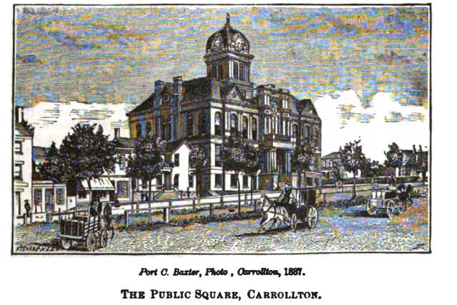
Photo: Henry Howe (1816-1893), public domain · Wikimedia Commons
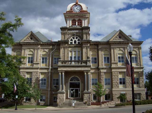
Photo: Nyttend, Wikimedia Commons, public domain · Wikimedia Commons
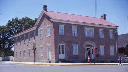
Photo: Bwsmith84, Wikimedia Commons, CC BY-SA 3.0 · Wikimedia Commons
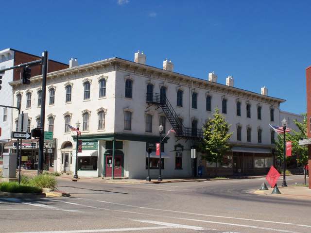
Photo: Roseohioresident, Wikimedia Commons, public domain · Wikimedia Commons
Local history sources: en.wikipedia.org · en.wikipedia.org · en.wikipedia.org · ohiohistory.org · en.wikipedia.org · en.wikipedia.org · en.wikipedia.org
Historic places
3 places in Carrollton on the National Register of Historic Places. Press a pin or a name for its whole record.
-
Carroll County CourthouseBuilding · Carrollton · listed 1974
- Address
- Courthouse Sq.
- Where
- Carrollton, Carroll County · ZIP 44615
- What it is
- Building
- Listed on the National Register
- 1974
- NRIS reference number
- 74001406
- Coordinates
- 40.57225, -81.08571
National Register file (NPS) ↗ Search Wikipedia ↗ Street map and directions ↗ On the Cracked Buckeye map
-
McCook, Daniel, HouseBuilding · Carrollton · listed 1970
- Address
- Public Sq.
- Where
- Carrollton, Carroll County · ZIP 44615
- What it is
- Building
- Listed on the National Register
- 1970
- NRIS reference number
- 70000486
- Coordinates
- 40.57207, -81.08713
National Register file (NPS) ↗ Search Wikipedia ↗ Street map and directions ↗ On the Cracked Buckeye map
-
Van Horn BuildingBuilding · Carrollton · listed 1987
- Address
- Public Sq., jct. of W. Main and N. Lisbon Sts.
- Where
- Carrollton, Carroll County · ZIP 44615
- What it is
- Building
- Listed on the National Register
- 1987
- NRIS reference number
- 87001375
- Coordinates
- 40.57306, -81.08630
National Register file (NPS) ↗ Search Wikipedia ↗ Street map and directions ↗ On the Cracked Buckeye map
Source: National Park Service, National Register of Historic Places point file. The listing year is shown where NPS's certification date agrees with the listing's reference number. Listing recognizes significance; it does not restrict a private owner.
Water
Mostly private wells The water here
- Carrollton Village99% of residentsGroundwater wells (10 wells)
- Rockwood Park1% of residentsGroundwater wells (2 wells)
Hospitals, fire stations and more
Inside Carrollton's boundary: 1 health center, 1 nursing home, 1 fire or EMS station, 3 public schools, 2 libraries, 1 museum, 2 police stations, 1 Toxics Release Inventory facility and 2 spill cases. Press a pin or a name for its whole record and its source.
Community health centers (1)
-
Southeast Healthcare - Carrollton Health Center SiteHealth center · Carrollton
- Run by
- a federally qualified health center
- Setting
- Clinic
- City
- Carrollton
- Coordinates
- 40.57766, -81.08409
Find a Health Center (HRSA) ↗ HRSA data (source) ↗ Street map and directions ↗
Source: HRSA health center service delivery sites, active, September 2026 (school-based sites left out). Health centers see patients whether or not they have insurance, with fees on a sliding scale.
Nursing homes (1)
-
Carroll Healthcare Center Inc5 of 5 stars · Carrollton
- Address
- 648 Longhorn Street, Carrollton, OH 44615
- Certified beds
- 52
- Residents on an average day
- 49
- Medicare overall rating
- 5 of 5 stars
- Health inspections
- 4 of 5 stars
- Staffing
- 5 of 5 stars
- Quality measures
- 4 of 5 stars
- Penalties since 2023
- none
- Ownership
- For profit - Corporation
- Takes
- Medicare and Medicaid
- Phone
- (330) 627-5501
- Medicare ID
- 365579
Medicare Care Compare ↗ CMS nursing home data (source) ↗ Street map and directions ↗
Source: CMS Care Compare nursing home provider and penalties files; Medicare star ratings run 1 to 5.
Fire and EMS stations (1)
-
Carrollton Fire DepartmentCarrollton
- Address
- 135 3rd Street Southwest, Carrollton, OH 44615
- Coordinates
- 40.57162, -81.08898
USGS National Map structures (source) ↗ Street map and directions ↗
Source: USGS National Map structures (most Ohio records last updated 2019 to 2022), checked against the Columbus and Cleveland station lists. The department that answers a call is set by jurisdiction and mutual aid, not by distance.
Public schools (3)
-
Carrollton Elementary School3 of 5 stars · Carrollton
- Address
- 252 3rd St NE, Carrollton, OH 44615
- School district
- Carrollton Ex Vill School District
- Kind (NCES)
- Regular School
- Students, 2023-24
- 796
- Teachers (full-time equivalent)
- 37
- Report card, 2025-26
- 3 of 5 stars
- Performance index
- 77.6%
- Ohio building IRN
- 008326
- NCES school ID
- 390452702155
NCES school record ↗ Ohio School Report Card ↗ Street map and directions ↗
-
Carrollton High School4 of 5 stars · Carrollton
- Address
- 205 Scio Rd SE, Carrollton, OH 44615
- School district
- Carrollton Ex Vill School District
- Kind (NCES)
- Regular School
- Students, 2023-24
- 970
- Teachers (full-time equivalent)
- 53
- Report card, 2025-26
- 4 of 5 stars
- Performance index
- 83.4%
- Four-year graduation rate
- 96.2%
- Ohio building IRN
- 005017
- NCES school ID
- 390452702154
NCES school record ↗ Ohio School Report Card ↗ Street map and directions ↗
-
Carrollton Middle School4.5 of 5 stars · Carrollton
- Address
- 205 Scio Road SW, Carrollton, OH 44615
- School district
- Carrollton Ex Vill School District
- Report card, 2025-26
- 4.5 of 5 stars
- Performance index
- 73%
- Ohio building IRN
- 021232
- NCES school ID
- 390452710894
NCES school record ↗ Ohio School Report Card ↗ Street map and directions ↗
Source: NCES EDGE public school locations 2024-25 and Common Core of Data 2023-24 (type, students, teachers); Ohio School Report Cards 2025-26 (Department of Education and Workforce), matched by name within the district.
Public libraries (2)
-
Carroll County District LibraryCentral library · Carrollton
- Address
- 70 Second St., Carrollton, OH 44615
- What it is
- Central library
- Library system
- Carroll County District Library
- Open
- 2,756 hours a year, 52 weeks
- Building
- 17,482 sq ft
- System's visits, FY2024
- 140,400
- System's loans, FY2024
- 190,961
- People the system serves
- 21,721
- Phone
- (330) 627-2613
IMLS Public Libraries Survey (source) ↗ Street map and directions ↗
-
Carroll County District Library (Carrollton)Bookmobile stop · Carrollton
- Address
- 70 N. Lisbon St., Carrollton, OH 44615
- What it is
- Bookmobile stop
- Library system
- Carroll County District Library
- Open
- 1,464 hours a year, 48 weeks
- System's visits, FY2024
- 140,400
- System's loans, FY2024
- 190,961
- People the system serves
- 21,721
- Phone
- (330) 627-2613
IMLS Public Libraries Survey (source) ↗ Street map and directions ↗
Source: IMLS Public Libraries Survey FY2024 (outlets and their systems). Any Ohio resident can get a free card at any Ohio public library.
Museums, historical societies, gardens and zoos (1)
-
Daniel Mccook HouseHistorical society · Carrollton
- What it is
- Historical society
- City
- Carrollton
- Coordinates
- 40.57223, -81.08673
Search Wikipedia ↗ IMLS Museum Data Files (source) ↗ Street map and directions ↗
The museum list is IMLS's 2018 file; a museum may have closed or moved since.
Source: IMLS Museum Data Files, 2018.
Police stations (2)
-
Carroll County Sheriff's OfficeCarrollton
- Address
- 43 2nd Street Southeast, Carrollton, OH 44615
- Coordinates
- 40.57193, -81.08595
USGS National Map structures (source) ↗ Street map and directions ↗
-
Carrollton Police DepartmentCarrollton
- Address
- 135 3rd Street Southwest, Carrollton, OH 44615
- Coordinates
- 40.57150, -81.08908
USGS National Map structures (source) ↗ Street map and directions ↗
Source: USGS National Map structures, police stations, corrected and completed by hand (September 2026). The department that answers a call is set by jurisdiction, not by distance.
Facilities reporting toxic releases (1)
-
Fusion Ceramics IncToxics Release Inventory · Carrollton
- Address
- 237 N High St, Carrollton, OH 44615
- County
- Carroll County
- Status
- Reports to the Toxics Release Inventory (active)
- EPA program ID
- 44615FSNCR237NH
- EPA registry ID
- 110002111982
EPA facility record ↗ EPA Facility Registry Service (source) ↗ Street map and directions ↗
Source: EPA Facility Registry Service, Toxics Release Inventory reporters. Reporting a release is required of large users of listed chemicals; it is not by itself a violation.
Spills reported since 2021 (2)
-
Fuel Oil/ Home Heating / Heating Oil2023-09-08 · Carrollton
- Reported
- 2023-09-08
- What spilled
- Fuel Oil/ Home Heating / Heating Oil
- Where
- Carrollton, Carroll County
- Ohio EPA district office
- NEDO
- Ohio EPA case number
- 2309EPA0001575
Ohio EPA spill reports (source) ↗ Street map and directions ↗
-
Fuel Diesel / Diesel Fuel (Vehicle On Or Off Road)2021-06-29 · Carrollton
- Reported
- 2021-06-29
- What spilled
- Fuel Diesel / Diesel Fuel (Vehicle On Or Off Road)
- Largest amount reported
- 25 gallons
- Where
- Carrollton, Carroll County
- Ohio EPA district office
- NEDO
- Ohio EPA case number
- 2106EPA0000948
Ohio EPA spill reports (source) ↗ Street map and directions ↗
Source: Ohio EPA emergency response spill reports, 2021 to September 2026, one point per case where Ohio EPA placed it. A report is what the caller or responder recorded; amounts are often blank or estimated.
Its ZIP codes
Each ZIP code that touches Carrollton, with the share of its residents who live here and the same headline figures as the ZIP page.
| ZIP | Share | Water | Radon | Home value | Schools | Flood |
|---|---|---|---|---|---|---|
| 44615 Carrollton | 28% | Mostly private wells | 7.9 pCi/L average radon | Median year built 1969 | Carrollton Exempted Village · 4 stars overall | 1.3% of residents in the 1% floodplain |
Local government
Who holds office in Carrollton, how its elections and ballot issues came out, and the state auditor's record.
Auditor of State record
- No fiscal caution, watch or emergency on the Auditor of State's lists.
- Financial Audit, 2022 to 2023, released 2025-01-07
The county
Carroll County: 7 ZIP codes, 15 cities, villages and townships, 19,207 people.
Nearby places
Rain and snow
How much has actually fallen on Carrollton, day by day, from 1892 to now. Daily totals, not averages.
- rain, last 30 days
- 1.53 in
- 2026-10-01 to 2026-10-30
- rain so far in 2026
- 44.5 in
- 8.8 in above normal for the date
- snow so far in 2026
- 29.1 in
- a normal year brings 26.6 in
- a normal year
- 41.9 in
- average of 30 years, 1991-2020
| Month | Rain (in) | Snow (in) | Days counted |
|---|---|---|---|
| October 2026 | 1.53 | — | 30 |
| September 2026 | 5.77 | — | 30 |
| August 2026 | 8.35 | — | 31 |
| July 2026 | 5.65 | — | 31 |
| June 2026 | 3.39 | — | 30 |
| May 2026 | 4.71 | — | 31 |
| April 2026 | 5.32 | — | 30 |
| March 2026 | 6.36 | 3.0 | 31 |
| February 2026 | 1.12 | 4.6 | 28 |
| January 2026 | 2.34 | 21.4 | 31 |
| December 2025 | 2.39 | 9.9 | 31 |
| November 2025 | 1.99 | 0.1 | 30 |
| Wettest year | 2004 — 57.6 in |
|---|---|
| Driest year | 1930 — 26.7 in |
| Snowiest year | 1894 — 67.8 in |
| Wettest day on record | 11 August 1948 — 3.21 in |
| Heaviest snowfall in a day | 20 April 1901 — 15.78 in |
| Deepest snow on the ground | 6 February 1977 — 22.47 in |
Mostly estimated. Only 1% of these days come from a gauge standing inside Carrollton - the rest are worked out from the nearest gauges around it, so read them as close estimates rather than readings.
48,856 days of records, 1892-09-01 to 2026-10-30. Source: NOAA NCEI GHCN-Daily, 3,240 gauges in and around Ohio. A day is "gauged" when a gauge standing inside the boundary reported it, and the value is the mean of those gauges. Otherwise it is interpolated by inverse distance from every gauge reporting within 50 miles. Nothing is carried forward, back-filled or smoothed. Against NOAA nClimDiv county monthly precipitation over 136,848 complete county-months (checked 2026-11-01): correlation 0.9515, median absolute difference 0.217 in a month. Built 2026-11-01 from the Cracked Buckeye precipitation archive. Snow is the softer number — snowfall is measured by hand with a ruler, no agency publishes a gridded county snowfall series, and blowing snow defeats every observer.
Environmental permits and filings
What Ohio EPA has on file for Carrollton: permits, inspections, violations, cleanups and the state loans behind sewer and water work. Every line links to the agency's own document.
- facilities and sites on file
- 18
- those placed on the map inside Carrollton
| Program | Facilities and sites |
|---|---|
| State water loans | 5 |
| Hazardous waste | 4 |
| Voluntary cleanup | 4 |
| Public drinking water | 2 |
| Wastewater and stormwater discharge | 2 |
| Air pollution | 1 |
Source: Ohio EPA eDocument portal (edocpub.epa.ohio.gov), indexed 2026-10-14. Facilities are placed on the map from Ohio EPA's own map layers, EPA's Facility Registry, coordinates written in the filings, or a geocoded street address. A permit filed under a private person's name (most are household septic systems) is counted but never named, placed or linked; licenses for individual workers and open-burning notices are left out entirely.
Quick answers
What county is Carrollton, Ohio in?
Carrollton is a village in Carroll County, Ohio, with 2,970 residents.
When was Carrollton, Ohio founded?
Carrollton was laid out 1815; incorporated 1834 (renamed and made county seat February 24, 1834). Founders on record: Peter Bohart. Source
How did Carrollton, Ohio get its name?
First platted as Centreville in 1815; renamed Carrollton on February 24, 1834 when it became the seat of the newly formed Carroll County, itself named for Charles Carroll of Carrollton, Maryland, the last surviving signer of the Declaration of Independence. Source
What ZIP code is Carrollton, Ohio?
Most of Carrollton is in ZIP code 44615.
Where does Carrollton, Ohio get its water?
The main water source for Carrollton (Carrollton Village): Mostly private wells.
Cite this page
Cite this page as:
Cracked Buckeye, "Carrollton, Carroll County", https://crackedbuckeye.com/place/carrollton/, built 2026-10-31, accessed [date].
How to cite · Report a correction · Built 2026-10-31