Local events in Warren Township, Tuscarawas County
Nothing is posted for Warren Township itself yet; here is what is on within 20 miles. All local events in Warren Township, Tuscarawas County
Know a calendar we should watch? Send the link
Checked October 20; the events page is refreshed daily.
Lakes near Warren Township, Tuscarawas County
The history under the water: the valley before, the dam, the stories. All Ohio lakes
How Warren Township, Tuscarawas County began
Warren Township was formed on March 31, 1819 from land that had earlier been part of One Leg Township, and lies in the northeastern part of Tuscarawas County, bordering Carroll County; when Carroll County was organized in 1832 it took two-thirds of Warren's original territory, and the county commissioners ceded new land from Fairfield and Goshen townships to keep the remainder viable. John McCrary, a Pennsylvanian who had traded on the Ohio and Mississippi as far as New Orleans, was the pioneer settler, arriving in 1804 with a sister and brother; Samuel Lappin followed in 1805 under an arrangement to split a section of land with two partners. The 1884 county history records that Native people used the One Leg Creek valley as a summer hunting ground and camped near New Cumberland over the winter of 1808-9, in generally peaceable relations with the settlers -- Mrs. Lappin made a standing practice of feeding visitors, and one man, John Henry, formed a lasting friendship with the Lappin family before leaving the region during the War of 1812. It covers 22.4 square miles and had 1,078 residents at the 2020 census; part of Atwood Lake lies within it. The township contains no incorporated municipality, and the well-documented Moravian and Separatist history of nearby Zoar belongs to Lawrence Township, not here.
Settled 1804 (John McCrary), incorporated 1819-03-31, by formed March 31, 1819 from Township 15, Range 7 and the west half of Township 14, Range 6, all previously part of One Leg Township; reduced by two-thirds when Carroll County organized in 1832, then given replacement territory from Fairfield and Goshen townships.
Where the name comes from
The reason the township was called Warren is not recorded. One Leg Creek, the township's main stream: it was named for a Native man who lived near its mouth and had lost a leg; some later writers wanted the name changed to the more euphonious 'Connotton' (Conotton), which Judge Israel S. Lappin opposed.
Before the town
The 1884 county history's Warren Township chapter records that Native people frequented the valley of One Leg Creek during the period of white settlement, using it chiefly as a summer hunting ground, though a large group camped near New Cumberland through the winter of 1808-9. Relations are described as amicable: visitors habitually left their guns outside a cabin as a token of friendship, and Mrs. Lappin made it a standing rule to feed any who visited her husband Samuel Lappin's cabin, in return for which the family received turkeys, venison and other game. One man, called John Henry in the source, formed a close attachment to the Lappin family and promised, with visible emotion, to warn them of any danger before the region's Native population left during the War of 1812; a few briefly returned afterward before departing permanently as farm settlement expanded. The nation or nations involved are not named. The township borders Fairfield and Sandy townships, through which the Tuscarawas River's historic Delaware (Lenape) towns and travel corridors ran.
Timeline
- — John McCrary, a Pennsylvanian who had worked as a boatman and trader on the Ohio and Mississippi as far as New Orleans, arrives with a sister, Margaret, and a brother, William McCrary, and builds the township's first cabin near the eastern line of Section 28, on the north bank of Indian Fork.
- — Samuel Lappin, a Fayette County, Pennsylvania farmer who had arranged to split a section of land with partners James and Finley McGrew and John Leatherman, arrives on June 18 with his family and settles on Section 35, along One Leg Creek; his son, Judge Israel S. Lappin, is still living in the township in 1884.
- — A large group of Native people camps near New Cumberland over the winter; they visit settler cabins, always leaving their guns outside as a sign of friendship, and Mrs. Lappin makes a standing practice of feeding visitors to her husband's cabin.
- — The Ohio legislature declares One Leg Creek navigable; the act is repealed in 1816, probably so that mill dams could be built across it.
- — During the War of 1812, the Native people who had frequented the valley leave the region; one man, John Henry, departs with visible reluctance after pledging to warn the Lappin family of any danger. A few return briefly afterward to old hunting grounds before leaving for good as settlement resumes.
- — The first schoolhouse, a rude log building in the southwest of Section 36, opens with William Vaughn, a traveling surveyor, as teacher for one three-month term at 50 cents per scholar.
- — Warren Township is formed on March 31 from land previously part of One Leg Township.
- — Philip Suter lays out New Cumberland in May on the northwest quarter of Section 29, 32 lots on Main and Cross streets, after persuading Samuel Lappin Jr. to open a store there.
- — The first church in the township, a Methodist meetinghouse, is built at New Cumberland about this year; the first Methodist class had met in cabins, including those of Abel Williams and Samuel Lappin.
- — A New Cumberland post office is established in 1831 or 1832 with David McConnell as postmaster.
- — The organization of Carroll County takes two-thirds of Warren Township's territory, leaving only eighteen square miles in Tuscarawas County; through the efforts of Judge Israel Lappin and others, the county commissioners cede four replacement sections from Fairfield and Goshen townships to keep the township viable.
- — New Cumberland incorporates as a village and elects Joseph Kerr mayor; the people soon tire of village government and it lapses by neglect after 1852.
- — New Cumberland reaches its peak of 203 people; it has 163 in 1880.
- — A larger Methodist church replaces the old one on Cross street in New Cumberland.
Stories
A friendship remembered: John Henry and the Lappins
The 1884 county history preserves one named, personal account among Warren Township's early Native visitors. Mrs. Lappin, wife of pioneer settler Samuel Lappin, made it her unbroken rule to feed any Native visitors who came to her husband's cabin; in return, and because Samuel Lappin had brought no gun of his own to his new home, they regularly supplied the family with turkeys, venison and other game in exchange for bread, potatoes and other favors. When the War of 1812 finally drove the region's Native population away, one man the source calls John Henry left with obvious reluctance -- the account says he departed "with tears in his eyes," having grown attached to the Lappin family, and promised that he or his son would warn them if danger ever threatened them during the war.
One Leg or Connotton
The creek that drains Warren Township was named One Leg for a Native man, living near its mouth, who had lost a leg. In 1808 the legislature declared it navigable, and the Corderys once boated down it to the Tuscarawas and as far as Coshocton and back with a load of corn, because in early times the stream carried more water. The act was repealed in 1816, probably to allow mill dams. By 1884 some people favored replacing the old name with the more euphonious Connotton; Judge Israel S. Lappin, who had lived by the creek since 1805, opposed the change and argued that One Leg was the proper name.
Photographs
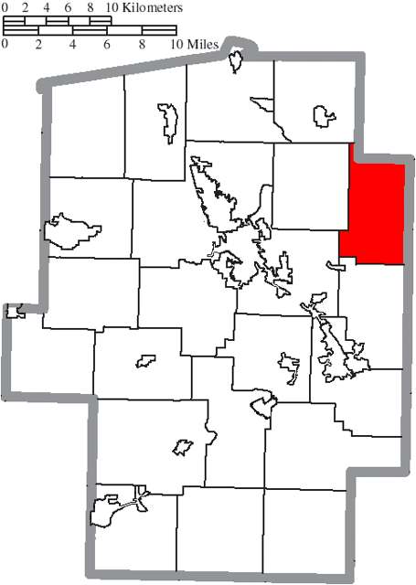
Photo: Ruhrfisch and Nyttend, Wikimedia Commons, CC BY-SA 3.0 · Wikimedia Commons
Local history sources: en.wikipedia.org · en.wikipedia.org · en.wikipedia.org · archive.org · commons.wikimedia.org · archive.org
Water
Mostly private wells The water here
- New Philadelphia City71% of residentsTuscarawas River valley sand-and-gravel aquifer (wells)
- Bolivar Village20% of residentsGroundwater wells (2 wells)
- Fohl Village MHP6% of residentsGroundwater wells (2 wells)
- Aqua Ohio - Midvale2% of residentsGroundwater wells (3 wells)
- Tcmsd-wainwright0% of residentsGroundwater wells (2 wells)
- Tuscarawas Village0% of residentsGroundwater wells (2 wells)
- Dover City0% of residentsSugar Creek Basin sand-and-gravel aquifer (Dover wellfield)
Hospitals, fire stations and more
Inside Warren Township, Tuscarawas County's boundary: 1 high-hazard dam, 1 public charging site, 9 shale and injection wells, 1 Superfund site and 3 spill cases. Press a pin or a name for its whole record and its source.
High-hazard dams (1)
-
Atwood DamIndian Fork of Conotton Creek · condition: not available
- Hazard class
- High: a failure would probably cost a life
- Condition
- Not Available
- River or stream
- Indian Fork of Conotton Creek
- Purpose
- Flood Risk Reduction;Fish and Wildlife Pond;Recreation
- Type
- Earth
- Height
- 65 ft
- Storage
- 49,700 acre-feet
- Completed
- 1936
- Owner type
- Federal
- County
- Tuscarawas County
- Nearest town (NID)
- New Cumberland
- Last inspection
- 05/20/2026
- Emergency action plan
- Yes
- NID ID
- OH00006
National Inventory of Dams record ↗ National Inventory of Dams (source) ↗ Street map and directions ↗
Source: U.S. Army Corps of Engineers National Inventory of Dams, August 2026. "High hazard" rates what a failure would cost downstream, not how likely one is; the condition is the state's assessment.
Public EV charging (1)
-
Atwood Lake Boats -Marina West - Tesla Destination1 Level 2 · Mineral City
- Address
- 9298 Atwood Lake Rd. NE, Mineral City, OH 44656
- Ports
- 1 Level 2
- Plugs
- Tesla (NACS)
- Network
- Tesla Destination
- Phone
- 877-798-3752
Station Locator (NREL) ↗ Alternative Fuels Data Center (source) ↗ Street map and directions ↗
Source: NREL Alternative Fuels Data Center station list (May 2026), public and open stations, the posts at one address counted as one site.
Shale and injection wells (9)
-
Gribi 1-9-1 3HUtica shale well
- What it is
- Utica shale well
- Drilled sideways
- Yes
- Operator
- Eog Ohio, Llc
- County
- Tuscarawas County
- API well number
- 34157254830100
- Coordinates
- 40.57341, -81.32817
ODNR oil and gas wells (source) ↗ Street map and directions ↗
The point is the surface well head (the pad); a horizontal well runs a mile or more underground from it.
-
R.D. & M.K. Grimm {Swiw#3} 1-D InjectionInjection well (Class II)
- What it is
- Injection well (Class II)
- Operator
- Brine X Llc
- County
- Tuscarawas County
- API well number
- 34157236900000
- Coordinates
- 40.48183, -81.27472
ODNR oil and gas wells (source) ↗ Street map and directions ↗
-
Shula Twr 1AUtica shale well · Well drilled
- What it is
- Utica shale well
- Drilled sideways
- Yes
- Status (ODNR)
- Well drilled
- Operator
- Eog Resources Inc.
- County
- Tuscarawas County
- API well number
- 34157255600000
- Coordinates
- 40.51011, -81.29818
ODNR oil and gas wells (source) ↗ Street map and directions ↗
The point is the surface well head (the pad); a horizontal well runs a mile or more underground from it.
-
Shula Twr 2BUtica shale well · Well drilled
- What it is
- Utica shale well
- Drilled sideways
- Yes
- Status (ODNR)
- Well drilled
- Operator
- Eog Resources Inc.
- County
- Tuscarawas County
- API well number
- 34157255570000
- Coordinates
- 40.51037, -81.29818
ODNR oil and gas wells (source) ↗ Street map and directions ↗
The point is the surface well head (the pad); a horizontal well runs a mile or more underground from it.
-
Shula Twr 3AUtica shale well · Drilling
- What it is
- Utica shale well
- Status (ODNR)
- Drilling
- Operator
- Eog Resources Inc.
- County
- Tuscarawas County
- API well number
- 34157255560000
- Coordinates
- 40.51015, -81.29818
ODNR oil and gas wells (source) ↗ Street map and directions ↗
-
Shula Twr 4BUtica shale well · Well drilled
- What it is
- Utica shale well
- Drilled sideways
- Yes
- Status (ODNR)
- Well drilled
- Operator
- Eog Resources Inc.
- County
- Tuscarawas County
- API well number
- 34157255580000
- Coordinates
- 40.51033, -81.29818
ODNR oil and gas wells (source) ↗ Street map and directions ↗
The point is the surface well head (the pad); a horizontal well runs a mile or more underground from it.
-
Shula Twr 5AUtica shale well · Well drilled
- What it is
- Utica shale well
- Drilled sideways
- Yes
- Status (ODNR)
- Well drilled
- Operator
- Eog Resources Inc.
- County
- Tuscarawas County
- API well number
- 34157255610000
- Coordinates
- 40.51020, -81.29818
ODNR oil and gas wells (source) ↗ Street map and directions ↗
The point is the surface well head (the pad); a horizontal well runs a mile or more underground from it.
-
Shula Twr 6BUtica shale well · Well drilled
- What it is
- Utica shale well
- Drilled sideways
- Yes
- Status (ODNR)
- Well drilled
- Operator
- Eog Resources Inc.
- County
- Tuscarawas County
- API well number
- 34157255590000
- Coordinates
- 40.51029, -81.29818
ODNR oil and gas wells (source) ↗ Street map and directions ↗
The point is the surface well head (the pad); a horizontal well runs a mile or more underground from it.
-
Shula Twr 7AUtica shale well · Well drilled
- What it is
- Utica shale well
- Drilled sideways
- Yes
- Status (ODNR)
- Well drilled
- Operator
- Eog Resources Inc.
- County
- Tuscarawas County
- API well number
- 34157255620000
- Coordinates
- 40.51024, -81.29818
ODNR oil and gas wells (source) ↗ Street map and directions ↗
The point is the surface well head (the pad); a horizontal well runs a mile or more underground from it.
Source: ODNR Division of Oil and Gas Resources well inventory (September 2026): drilled Utica, Marcellus and horizontal wells and Class II injection wells not plugged. Older vertical wells are on the full map.
Superfund sites (1)
-
Pine View PlatingSuperfund program · Mineral City
- Address
- 4529 New Cumberland Rd. Nw, Mineral City, OH 44656
- County
- Tuscarawas County
- Status
- Superfund program site, not on the National Priorities List
- EPA program ID
- OHN000509988
- EPA registry ID
- 110001630557
EPA facility record ↗ EPA Facility Registry Service (source) ↗ Street map and directions ↗
Source: EPA Facility Registry Service, Superfund (SEMS) and National Priorities List sites. Many program sites were assessed and needed no cleanup.
Spills reported since 2021 (3)
-
Fuel Diesel / Diesel Fuel (Vehicle On Or Off Road)2025-12-18 · Warren Twp
- Reported
- 2025-12-18
- What spilled
- Fuel Diesel / Diesel Fuel (Vehicle On Or Off Road)
- Largest amount reported
- 20 gallons
- Where
- Warren Twp, Tuscarawas County
- Ohio EPA district office
- SEDO
- Ohio EPA case number
- 2512EPA0002022
Ohio EPA spill reports (source) ↗ Street map and directions ↗
-
Bentonite / Drilling Mud2025-10-28 · Union Twp
- Reported
- 2025-10-28
- What spilled
- Bentonite / Drilling Mud
- Where
- Union Twp, Tuscarawas County
- Ohio EPA district office
- SEDO
- Ohio EPA case number
- 2510EPA0001760
Ohio EPA spill reports (source) ↗ Street map and directions ↗
-
Natural Gas2025-09-08 · Warren Twp
- Reported
- 2025-09-08
- What spilled
- Natural Gas
- Where
- Warren Twp, Tuscarawas County
- Ohio EPA district office
- SEDO
- Ohio EPA case number
- 2509EPA0001520
Ohio EPA spill reports (source) ↗ Street map and directions ↗
Source: Ohio EPA emergency response spill reports, 2021 to September 2026, one point per case where Ohio EPA placed it. A report is what the caller or responder recorded; amounts are often blank or estimated.
Its ZIP codes
Each ZIP code that touches Warren Township, Tuscarawas County, with the share of its residents who live here and the same headline figures as the ZIP page.
| ZIP | Share | Water | Radon | Home value | Schools | Flood |
|---|---|---|---|---|---|---|
| 44656 Sandy Township and Mineral City | 25% | Mostly private wells | 6.5 pCi/L average radon | Median year built 1961 | Tuscarawas Valley Local · 4 stars overall | 7.8% of residents in the 1% floodplain |
| 44675 Monroe Township and Sherrodsville | 13% | Mostly private wells | 10.7 pCi/L average radon | Median year built 1974 | Conotton Valley Union Local · 4.5 stars overall | 3.8% of residents in the 1% floodplain |
| 44663 New Philadelphia | 1% | Wells in the sand-and-gravel aquifer within the Tuscarawas River valley near New Philadelphia | 5.3 pCi/L average radon | Median year built 1956 | New Philadelphia City · 3 stars overall | 5.2% of residents in the 1% floodplain |
Local government
Who holds office in Warren Township, Tuscarawas County, how its elections and ballot issues came out, and the state auditor's record.
Ballot issues
| Date | Issue | For | Against | Result |
|---|---|---|---|---|
| 2022-11-08 | 19: 19 Warren Township Fire Warren Township | 389 | 73 | Passed (84.2% for) |
Elections for office
| Date | Office | Candidates and votes |
|---|---|---|
| 2019-11-05 | Township Trustee | William R. McDonnell 104, 100.0% |
| 2019-11-05 | Township Fiscal Officer | Mary Ellen Gooding 100, 100.0% |
Winners in bold. Results from the county board of elections' official canvass unless marked.
Auditor of State record
- No fiscal caution, watch or emergency on the Auditor of State's lists.
- Agreed Upon Procedures, 2023 to 2024, released 2025-07-15
The county
Tuscarawas County: 17 ZIP codes, 40 cities, villages and townships, 92,903 people.
Nearby places
Quick answers
What county is Warren Township, Ohio in?
Warren Township, Tuscarawas County is a township in Tuscarawas County, Ohio, with 1,078 residents.
When was Warren Township, Ohio founded?
Warren Township, Tuscarawas County was settled 1804 (John McCrary); incorporated 1819-03-31. Founders on record: formed March 31, 1819 from Township 15, Range 7 and the west half of Township 14, Range 6, all previously part of One Leg Township; reduced by two-thirds when Carroll County organized in 1832, then given replacement territory from Fairfield and Goshen townships. Source
How did Warren Township, Ohio get its name?
The reason the township was called Warren is not recorded. Source
What ZIP code is Warren Township, Ohio?
Warren Township, Tuscarawas County is served by ZIP codes 44656 and 44675; 44656 holds the largest share of its residents.
Where does Warren Township, Ohio get its water?
The main water source for Warren Township, Tuscarawas County (New Philadelphia City): Mostly private wells.
Cite this page
Cite this page as:
Cracked Buckeye, "Warren Township, Tuscarawas County", https://crackedbuckeye.com/place/warren-township-tuscarawas-county/, built 2026-10-31, accessed [date].
How to cite · Report a correction · Built 2026-10-31
