Local events in Liberty Township, Trumbull County
Liberty Township itself has 2 events posted in the next 90 days; the others here are within 10 miles. All local events in Liberty Township, Trumbull County
Checked October 20; the events page is refreshed daily.
How Liberty Township, Trumbull County began
Liberty Township was organized in 1806 when residents of range two, town three petitioned for a separate township -- the 1882 county history notes wryly that they thereby 'gained their Liberty' and the name stuck. Its earliest settlers date to 1798-1800: Henry Swager, James Matthews, John Stull and others arrived in those first years, with Swager -- by two elderly residents' independent recollection -- most likely the first. Coal, discovered on Alexander McCleery's farm in 1860, remade the township's economy over the following decades. Of its small internal villages, Church Hill took its name from a mapmaker's coincidence -- its post office, first registered as 'Liberty,' had to be renamed when Washington discovered the name already in use, and the church then under construction on the local high ground suggested 'Church Hill' -- while nearby Sodom got its name as an 1840s temperance lecturer's joke about a poorly attended meeting. Girard, the township's largest village, later incorporated separately as its own city.
Settled 1798 (Henry Swager, likely first settler, per two independent elderly residents' recollections), incorporated 1806, by petition of area residents, by Henry Swager, likely first settler; organized as a township by petition in 1806.
Where the name comes from
The 1882 county history explains the township's name with a small joke of its own: in 1806 the residents of range two, town three petitioned the proper authorities and 'gained their Liberty,' and the township took that name from the petition's success. Separately, the internal village of Church Hill took its name indirectly from the township's own original name: its post office was first registered as 'Liberty' in 1833 under postmaster Matthew Walker, but the federal post office department in Washington reported that name already taken, so, with a Presbyterian church then under construction on the local high ground, 'Church Hill' was suggested and accepted instead.
Before the town
No Native village, camp or treaty event specific to Liberty Township is recorded in the sources we reviewed. The township sits at the southern edge of the Mahoning valley the county's 1882 history describes as Delaware-occupied hunting ground used seasonally by Seneca and Mingo bands through the 1700s, and its proximity to the Mahoning River corridor -- the same corridor used by these nations further north and south -- makes seasonal travel through the area likely, but no source found names a specific site inside the township's present boundaries.
Nations recorded here: Lenape (Delaware), Seneca, Mingo (Seneca-Cayuga).
Timeline
- — James Matthews settles in the township's southwest, later keeping the first public house and operating the first distillery in the township; John Stull also settles this year near Girard.
- — Henry Swager settles west of the later Church Hill; by two elderly residents' independent recollection he is likely the township's first settler, arriving as early as 1798.
- — Valentine Stull arrives alone and purchases a half section of land, moving his family from Washington County, Pennsylvania the following year.
- — Area residents petition successfully for a separate township, 'gaining their Liberty' -- the origin, per the 1882 county history, of the township's name.
- — Rev. Henry Yambert preaches at the house of George Herring, the first meetings of the Evangelical Association church in the township.
- — Church Hill's post office is established under postmaster Matthew Walker, first registered as 'Liberty' but renamed 'Church Hill' after Washington reports the name already taken.
- — A temperance lecturer, Dr. Fisher, jokingly compares a poorly attended meeting at a schoolhouse to 'a perfect Sodom'; the name sticks to the small village that later grows up on the site.
- — Coal is discovered on Alexander McCleery's farm, leased by a Mr. Strain, launching the township's coal industry.
- — The Church Hill Coal Company forms and opens a mine at the village.
- — Sodom's settlement becomes more prominent when a coal bank opens there.
- — The Briar Hill company opens the Kline coal bank.
- — The Henry Barnhisel House, a Greek Revival farmhouse, is built at what is now 1011 State Street, within the township's borders near Girard; it will later be listed on the National Register of Historic Places.
- — The 2020 census counts 21,514 residents within Liberty Township's geographic area, including Girard, making it one of Trumbull County's more populous townships.
Stories
A joke that named a village
Church Hill and its small neighbor Sodom both got their names by accident. Church Hill's post office was first registered in 1833 as simply 'Liberty,' matching the township, but the post office department in Washington sent word back that another Ohio office already carried that name; with a Presbyterian church then rising on a local elevation, 'Church Hill' was proposed and stuck -- and proved so fitting that by 1882 the village held five churches (Old-School Presbyterian, Methodist Episcopal, Welsh Methodist, Welsh Baptist and Welsh Independent) against ten saloons, a ratio the county history notes with evident amusement, adding that despite it the community 'is, from all appearances, a quiet and pleasant neighborhood.' A few miles off, around 1840, a temperance lecturer named Dr. Fisher spoke to a disappointing turnout at a schoolhouse, then joked at his next stop in Church Hill that the place must be 'a perfect Sodom' -- and the name outlived the joke, attaching itself permanently to the small mining settlement that later grew up on the spot.
Coal under the farm
For its first half-century Liberty Township was unremarkable farm country south of Warren, its scattered villages -- Girard, Church Hill, Sodom, Seceders Corners -- little more than crossroads. That changed in 1860, when coal turned up on Alexander McCleery's farm; within a few years it had grown into a major local industry that ran for roughly forty years, tying the township's fortunes to the same Mahoning Valley coal-and-iron economy that was industrializing Girard, Niles and Youngstown just beyond its borders. The coal boom faded by 1900, roughly the same period when Girard itself grew large enough to break away from the township and incorporate as its own city -- so Liberty Township's nineteenth-century industrial moment and the loss of its most substantial village happened on almost the same timeline.
Photographs
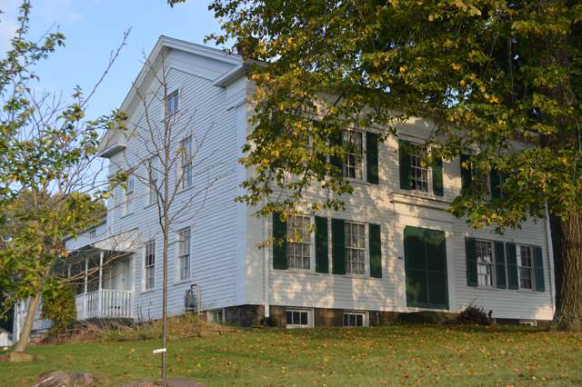
Photo: Nyttend, public domain · Wikimedia Commons
Local history sources: en.wikipedia.org · en.wikipedia.org · en.wikipedia.org · en.wikipedia.org · en.wikipedia.org · archive.org · commons.wikimedia.org
Water
Meander Creek Reservoir + Berlin Reservoir (Mahoning River basin) The water here
- Youngstown City57% of residentsMeander Creek Reservoir + Berlin Reservoir (Mahoning River basin)
- Girard City34% of residentsMeander Creek Reservoir (via Niles/MVSD, blended)
- Hubbard City7% of residentsShenango River / Shenango River Lake (Pymatuning area) surface intake
- Niles City2% of residentsMeander Creek Reservoir + Berlin Reservoir (Mahoning River basin)
- Stoneybrooke Village MHP0% of residentsGroundwater wells (2 wells)
- Aqua Ohio - Struthers0% of residentsEvans Lake (Yellow Creek impoundment)
- Valley Mobile Homes0% of residentsGroundwater wells (2 wells)
Hospitals, fire stations and more
Inside Liberty Township, Trumbull County's boundary: 2 hospitals, 3 health centers, 2 nursing homes, 2 fire and EMS stations, 4 public schools, 2 private schools, 1 library, 1 museum, 1 police station, 1 Superfund site, 2 Toxics Release Inventory facilities and 14 spill cases. Press a pin or a name for its whole record and its source.
Hospitals (2)
-
Belmont Pines HospitalPsychiatric hospital · Youngstown
- What it is
- Psychiatric hospital
- Address
- 615 Churchill-Hubbard Road, Youngstown, OH 44505
- County
- Trumbull County
- Beds
- 53
- Ownership
- Proprietary
- Phone
- (330) 759-2700
Where HIFLD got this record ↗ HIFLD hospitals (source) ↗ Street map and directions ↗
-
Generations Behavioral Health - Youngstown, LlcPsychiatric hospital · Youngstown
- What it is
- Psychiatric hospital
- Address
- 196 Colonial Drive, Youngstown, OH 44505
- County
- Trumbull County
- Beds
- 76
- Ownership
- Proprietary
- Medicare overall rating
- not rated
- Emergency department (Medicare)
- No
- Medicare reports it as
- Generations Behavioral Health-Youngstown Llc
- Phone
- (234) 232-7478
- Medicare ID
- 364060
Medicare Care Compare ↗ Hospital's website ↗ Where HIFLD got this record ↗ HIFLD hospitals (source) ↗ Street map and directions ↗
Source: HIFLD hospitals inventory via FEMA (closed hospitals it still lists left out, hospitals opened since added), with Medicare Care Compare ratings matched by name and address.
Community health centers (3)
-
3999 BelmontHealth center · Youngstown
- Run by
- a federally qualified health center
- Setting
- Clinic
- City
- Youngstown
- Coordinates
- 41.15311, -80.66491
Find a Health Center (HRSA) ↗ HRSA data (source) ↗ Street map and directions ↗
-
RISE RecoveryHealth center · Youngstown
- Run by
- a federally qualified health center
- Setting
- Clinic
- City
- Youngstown
- Coordinates
- 41.13936, -80.66554
Find a Health Center (HRSA) ↗ HRSA data (source) ↗ Street map and directions ↗
-
Valley Health Services - LibertyHealth center · Youngstown
- Run by
- a federally qualified health center
- Setting
- Clinic
- City
- Youngstown
- Coordinates
- 41.17006, -80.66586
Find a Health Center (HRSA) ↗ HRSA data (source) ↗ Street map and directions ↗
Source: HRSA health center service delivery sites, active, September 2026 (school-based sites left out). Health centers see patients whether or not they have insurance, with fees on a sliding scale.
Nursing homes (2)
-
Liberty Health Care Center Inc2 of 5 stars · Youngstown
- Address
- 1355 Churchill Hubbard Rd, Youngstown, OH 44505
- Certified beds
- 110
- Residents on an average day
- 100
- Medicare overall rating
- 2 of 5 stars
- Health inspections
- 2 of 5 stars
- Staffing
- 3 of 5 stars
- Quality measures
- 4 of 5 stars
- Penalties since 2023
- 2 fines totalling $83,401 (latest 2025-09-16)
- Ownership
- For profit - Corporation
- Chain
- WINDSOR HOUSE, INC.
- Takes
- Medicare and Medicaid
- Phone
- (330) 759-7858
- Medicare ID
- 366113
Medicare Care Compare ↗ CMS nursing home data (source) ↗ Street map and directions ↗
-
Shepherd of The Valley Liberty3 of 5 stars · Girard
- Address
- 1501 Tibbetts Wick Road, Girard, OH 44420
- Certified beds
- 79
- Residents on an average day
- 66
- Medicare overall rating
- 3 of 5 stars
- Health inspections
- 3 of 5 stars
- Staffing
- 4 of 5 stars
- Quality measures
- 3 of 5 stars
- Penalties since 2023
- none
- Ownership
- Non profit - Church related
- Continuing care retirement community
- Yes
- Takes
- Medicare and Medicaid
- Phone
- (330) 544-0771
- Medicare ID
- 365298
Medicare Care Compare ↗ CMS nursing home data (source) ↗ Street map and directions ↗
Source: CMS Care Compare nursing home provider and penalties files; Medicare star ratings run 1 to 5.
Fire and EMS stations (2)
-
Liberty Township Fire Department Station 34Youngstown
- Address
- 5920 Belmont Avenue, Youngstown, OH 44505
- Coordinates
- 41.18222, -80.66531
USGS National Map structures (source) ↗ Street map and directions ↗
-
Liberty Township Fire Department Station 35Youngstown
- Address
- 4001 Logan Way, Youngstown, OH 44505
- Coordinates
- 41.15465, -80.63160
USGS National Map structures (source) ↗ Street map and directions ↗
Source: USGS National Map structures (most Ohio records last updated 2019 to 2022), checked against the Columbus and Cleveland station lists. The department that answers a call is set by jurisdiction and mutual aid, not by distance.
Public schools (4)
-
E J Blott Elementary School3.5 of 5 stars · Youngstown
- Address
- 4115 Shady Rd, Youngstown, OH 44505
- School district
- Liberty Local School District
- Kind (NCES)
- Regular School
- Students, 2023-24
- 380
- Teachers (full-time equivalent)
- 28
- Report card, 2025-26
- 3.5 of 5 stars
- Performance index
- 75%
- Ohio building IRN
- 002980
- NCES school ID
- 390501903870
NCES school record ↗ Ohio School Report Card ↗ Street map and directions ↗
-
Liberty High School3 of 5 stars · Youngstown
- Address
- 1 Leopard Way, Youngstown, OH 44505
- School district
- Liberty Local School District
- Kind (NCES)
- Regular School
- Students, 2023-24
- 524
- Teachers (full-time equivalent)
- 24
- Report card, 2025-26
- 3 of 5 stars
- Performance index
- 65.8%
- Four-year graduation rate
- 94.9%
- Ohio building IRN
- 020388
- NCES school ID
- 390501903871
NCES school record ↗ Ohio School Report Card ↗ Street map and directions ↗
-
Liberty Leopard Cyber AcademyYoungstown
- Address
- 4115 Shady Rd, Youngstown, OH 44505
- Kind (NCES)
- Regular School
- Students, 2023-24
- 25
- NCES school ID
- 390501910887
-
William S Guy Middle School4 of 5 stars · Youngstown
- Address
- 4115 Shady Rd, Youngstown, OH 44505
- School district
- Liberty Local School District
- Kind (NCES)
- Regular School
- Students, 2023-24
- 230
- Teachers (full-time equivalent)
- 11
- Report card, 2025-26
- 4 of 5 stars
- Performance index
- 69.6%
- Ohio building IRN
- 014803
- NCES school ID
- 390501903872
NCES school record ↗ Ohio School Report Card ↗ Street map and directions ↗
Source: NCES EDGE public school locations 2024-25 and Common Core of Data 2023-24 (type, students, teachers); Ohio School Report Cards 2025-26 (Department of Education and Workforce), matched by name within the district.
Private schools (2)
-
Victory Christian SchoolPrivate, conservative Christian · Niles
- Address
- 2053 Pleasant Valley Rd, Niles, OH 44446
- Kind
- conservative Christian
- Students, 2023-24
- 143
- Teachers (full-time equivalent)
- 15.1
- Students per teacher
- 9.4702
- Phone
- (330) 539-9827
- NCES private school ID
- 01062893
-
Villa Maria TeresaPrivate, Catholic · Hubbard
- Address
- 50 Warner Rd, Hubbard, OH 44425
- Kind
- Catholic
- Students, 2023-24
- 12
- Teachers (full-time equivalent)
- 1.5
- Students per teacher
- 8
- Phone
- (330) 759-7383
- NCES private school ID
- K9304384
Source: NCES Private School Survey 2023-24.
Public libraries (1)
-
Liberty Branch LibraryBranch · Youngstown
- Address
- 415 Churchill- Hubbard Road, Youngstown, OH 44505
- What it is
- Branch
- Library system
- Warren-Trumbull County Public Library
- Open
- 3,120 hours a year, 52 weeks
- Building
- 10,200 sq ft
- System's visits, FY2024
- 434,200
- System's loans, FY2024
- 665,653
- People the system serves
- 142,591
- Phone
- (330) 759-2589
IMLS Public Libraries Survey (source) ↗ Street map and directions ↗
Source: IMLS Public Libraries Survey FY2024 (outlets and their systems). Any Ohio resident can get a free card at any Ohio public library.
Museums, historical societies, gardens and zoos (1)
-
Liberty Historical SocietyHistorical society · Girard
- What it is
- Historical society
- City
- Girard
- Coordinates
- 41.17146, -80.67566
Search Wikipedia ↗ IMLS Museum Data Files (source) ↗ Street map and directions ↗
The museum list is IMLS's 2018 file; a museum may have closed or moved since.
Source: IMLS Museum Data Files, 2018.
Police stations (1)
-
Liberty Township Police DepartmentYoungstown
- Address
- 1315 Churchill Hubbard Road, Youngstown, OH 44505
- Coordinates
- 41.16190, -80.64234
USGS National Map structures (source) ↗ Street map and directions ↗
Source: USGS National Map structures, police stations, corrected and completed by hand (September 2026). The department that answers a call is set by jurisdiction, not by distance.
Superfund sites (1)
-
Liberty Auto WreckingSuperfund program · Youngstown
- Address
- 2630 Hubbard Road, Youngstown, OH 44505
- County
- Mahoning County
- Status
- Superfund program site, not on the National Priorities List
- EPA program ID
- OHSFN0507827
- EPA registry ID
- 110009305135
EPA facility record ↗ EPA Facility Registry Service (source) ↗ Street map and directions ↗
Source: EPA Facility Registry Service, Superfund (SEMS) and National Priorities List sites. Many program sites were assessed and needed no cleanup.
Facilities reporting toxic releases (2)
-
Dart Metals Trading CoToxics Release Inventory · Youngstown
- Address
- 19 Colonial Dr, Youngstown, OH 44505
- County
- Mahoning County
- Status
- Reports to the Toxics Release Inventory
- EPA program ID
- TRI_OFFSITE_580
- EPA registry ID
- 110063650464
EPA facility record ↗ EPA Facility Registry Service (source) ↗ Street map and directions ↗
-
Youngstown Welding & Eng CoToxics Release Inventory · Youngstown
- Address
- 3700 Oakwood Avenue, Youngstown, OH 44509
- County
- Trumbull County
- Status
- Reports to the Toxics Release Inventory (active)
- EPA program ID
- 44509YNGST3700O
- EPA registry ID
- 110002111866
EPA facility record ↗ EPA Facility Registry Service (source) ↗ Street map and directions ↗
Source: EPA Facility Registry Service, Toxics Release Inventory reporters. Reporting a release is required of large users of listed chemicals; it is not by itself a violation.
Spills reported since 2021 (14)
-
Fuel Diesel / Diesel Fuel (Vehicle On Or Off Road)2025-04-10 · Liberty Twp
- Reported
- 2025-04-10
- What spilled
- Fuel Diesel / Diesel Fuel (Vehicle On Or Off Road)
- Largest amount reported
- 100 gallons
- Where
- Liberty Twp, Trumbull County
- Ohio EPA district office
- NEDO
- Ohio EPA case number
- 2504EPA0000540
Ohio EPA spill reports (source) ↗ Street map and directions ↗
-
Fuel Diesel / Diesel Fuel (Vehicle On Or Off Road)2024-09-29 · Liberty Twp
- Reported
- 2024-09-29
- What spilled
- Fuel Diesel / Diesel Fuel (Vehicle On Or Off Road)
- Where
- Liberty Twp, Trumbull County
- Ohio EPA district office
- NEDO
- Ohio EPA case number
- 2409EPA0001678
Ohio EPA spill reports (source) ↗ Street map and directions ↗
-
Oil Transformer Non Pcb2024-06-17 · Liberty Twp
- Reported
- 2024-06-17
- What spilled
- Oil Transformer Non Pcb
- Largest amount reported
- 5 gallons
- Where
- Liberty Twp, Trumbull County
- Ohio EPA district office
- NEDO
- Ohio EPA case number
- 2406EPA0001022
Ohio EPA spill reports (source) ↗ Street map and directions ↗
-
Material Unknown2023-06-08 · Liberty Twp
- Reported
- 2023-06-08
- What spilled
- Material Unknown
- Where
- Liberty Twp, Trumbull County
- Ohio EPA district office
- NEDO
- Ohio EPA case number
- 2306EPA0000948
Ohio EPA spill reports (source) ↗ Street map and directions ↗
-
Oil Motor / Lube Oil / Vehicle2023-04-21 · Liberty Twp
- Reported
- 2023-04-21
- What spilled
- Oil Motor / Lube Oil / Vehicle
- Where
- Liberty Twp, Trumbull County
- Ohio EPA district office
- NEDO
- Ohio EPA case number
- 2304EPA0000644
Ohio EPA spill reports (source) ↗ Street map and directions ↗
-
Natural Gas2023-04-12 · Liberty Twp
- Reported
- 2023-04-12
- What spilled
- Natural Gas
- Where
- Liberty Twp, Trumbull County
- Ohio EPA district office
- NEDO
- Ohio EPA case number
- 2304EPA0000578
Ohio EPA spill reports (source) ↗ Street map and directions ↗
-
Fuel Diesel / Diesel Fuel (Vehicle On Or Off Road)2023-01-29 · Liberty Twp
- Reported
- 2023-01-29
- What spilled
- Fuel Diesel / Diesel Fuel (Vehicle On Or Off Road)
- Largest amount reported
- 30 gallons
- Where
- Liberty Twp, Trumbull County
- Ohio EPA district office
- NEDO
- Ohio EPA case number
- 2301EPA0000141
Ohio EPA spill reports (source) ↗ Street map and directions ↗
-
Fuel Diesel / Diesel Fuel (Vehicle On Or Off Road)2023-01-27 · Liberty Twp
- Reported
- 2023-01-27
- What spilled
- Fuel Diesel / Diesel Fuel (Vehicle On Or Off Road)
- Largest amount reported
- 50 gallons
- Where
- Liberty Twp, Trumbull County
- Ohio EPA district office
- NEDO
- Ohio EPA case number
- 2301EPA0000132
Ohio EPA spill reports (source) ↗ Street map and directions ↗
-
Fuel Diesel / Diesel Fuel (Vehicle On Or Off Road) Reached water2022-07-18 · Liberty Twp
- Reported
- 2022-07-18
- What spilled
- Fuel Diesel / Diesel Fuel (Vehicle On Or Off Road)
- Reached a waterway
- 99 - Unnamed
- Where
- Liberty Twp, Trumbull County
- Ohio EPA district office
- NEDO
- Ohio EPA case number
- 2207EPA0001097
Ohio EPA spill reports (source) ↗ Street map and directions ↗
-
Oil Transformer Non Pcb2021-12-09 · Liberty Twp
- Reported
- 2021-12-09
- What spilled
- Oil Transformer Non Pcb
- Largest amount reported
- 8 gallons
- Where
- Liberty Twp, Trumbull County
- Ohio EPA district office
- NEDO
- Ohio EPA case number
- 2112EPA0001837
Ohio EPA spill reports (source) ↗ Street map and directions ↗
-
Fuel Diesel / Diesel Fuel (Vehicle On Or Off Road)2021-10-07 · Liberty Twp
- Reported
- 2021-10-07
- What spilled
- Fuel Diesel / Diesel Fuel (Vehicle On Or Off Road)
- Largest amount reported
- 5 gallons
- Where
- Liberty Twp, Trumbull County
- Ohio EPA district office
- NEDO
- Ohio EPA case number
- 2110EPA0001589
Ohio EPA spill reports (source) ↗ Street map and directions ↗
-
Fuel Diesel / Diesel Fuel (Vehicle On Or Off Road)2021-08-18 · Liberty Twp
- Reported
- 2021-08-18
- What spilled
- Fuel Diesel / Diesel Fuel (Vehicle On Or Off Road)
- Where
- Liberty Twp, Trumbull County
- Ohio EPA district office
- NEDO
- Ohio EPA case number
- 2108EPA0001285
Ohio EPA spill reports (source) ↗ Street map and directions ↗
-
Fuel Gasoline ( 25% Ethanol Not E85)2021-03-30 · Liberty Twp
- Reported
- 2021-03-30
- What spilled
- Fuel Gasoline ( 25% Ethanol Not E85)
- Largest amount reported
- 50 gallons
- Where
- Liberty Twp, Trumbull County
- Ohio EPA district office
- NEDO
- Ohio EPA case number
- 2103EPA0000427
Ohio EPA spill reports (source) ↗ Street map and directions ↗
-
Other / All Other / Trade Name / Mixture / Solution Etc2026-08-13 · Liberty Twp
- Reported
- 2026-08-13
- What spilled
- Other / All Other / Trade Name / Mixture / Solution Etc
- Where
- Liberty Twp, Trumbull County
- Ohio EPA district office
- NEDO
- Ohio EPA case number
- 2608EPA0001495
Ohio EPA spill reports (source) ↗ Street map and directions ↗
Source: Ohio EPA emergency response spill reports, 2021 to September 2026, one point per case where Ohio EPA placed it. A report is what the caller or responder recorded; amounts are often blank or estimated.
Its ZIP codes
Each ZIP code that touches Liberty Township, Trumbull County, with the share of its residents who live here and the same headline figures as the ZIP page.
On the November 3, 2026 ballot
Statewide question: State Issue 3: Voter ID
Races, candidates and every question for an address: your ballot. County offices and judges are on your county board's sample ballot.
The county
Mahoning County: 28 ZIP codes, 23 cities, villages and townships with pages here, 224,706 people (Census Bureau estimate, July 2025).
Nearby places
Quick answers
What county is Liberty Township, Ohio in?
Liberty Township, Trumbull County is a township in Mahoning County, Ohio, with 12,040 residents.
When was Liberty Township, Ohio founded?
Liberty Township, Trumbull County was settled 1798 (Henry Swager, likely first settler, per two independent elderly residents' recollections); incorporated 1806, by petition of area residents. Founders on record: Henry Swager, likely first settler; organized as a township by petition in 1806. Source
How did Liberty Township, Ohio get its name?
The 1882 county history explains the township's name with a small joke of its own: in 1806 the residents of range two, town three petitioned the proper authorities and 'gained their Liberty,' and the township took that name from the petition's success. Source
What ZIP code is Liberty Township, Ohio?
Liberty Township, Trumbull County is served by ZIP codes 44505, 44420, 44425 and 44504; 44505 holds the largest share of its residents.
Where does Liberty Township, Ohio get its water?
The main water source for Liberty Township, Trumbull County (Youngstown City): Meander Creek Reservoir + Berlin Reservoir (Mahoning River basin).
Cite this page
Cite this page as:
Cracked Buckeye, "Liberty Township, Trumbull County", https://crackedbuckeye.com/place/liberty-township-trumbull-county/, built 2026-10-31, accessed [date].
How to cite · Report a correction · Built 2026-10-31