How Hebron began
Hebron was laid out in 1827 by John Smith, the sixth town platted in Licking County, at the point in Union Township where the Ohio and Erie Canal's summit level crossed the National Road — a crossroads that made it, for a time, the largest grain and pork market in the Licking Valley. Union Township's own first canal boat, built at Hebron in 1827-28, was so poorly constructed it never got past its own lock and ended its days as an abandoned drinking den. Railroads later drew the county's commerce elsewhere, a fire around 1900 destroyed much of the business district, and the Ohio Electric interurban briefly revived the village before its own decline; Hebron has since settled into a smaller, steadier life, building its own municipal water system beginning in 1935.
Platted 1827, by John Smith (the sixth town laid out in Licking County), by John Smith.
Where the name comes from
No source consulted explains why the town was named for the biblical city of Hebron, a common naming choice among Ohio towns platted in this period. A GNIS historical place name, Moscow, once identified a separate small settlement within what is now Hebron's ZIP code, though no source consulted describes it further.
Before the town
Hebron was the principal town of the former Union Township, an area the 1881 county history's own resident correspondent, Samuel Park, esq., surveyed in detail for Mound Builder remains: forts and mounds along the ridge between Union and Granville townships, an artificial pool on a narrow ridge near Licking church, and a cluster of at least fifty mound-like knobs on a three-hundred-acre tract, several confirmed by a fallen tree's exposed root as artificial rather than natural. On his own farm, later the Licking County Infirmary farm, Park recorded an 'Indian arrow shop,' a scatter of several bushels of flint chips and unfinished arrow points where no natural flint occurred, the material apparently hauled from Flint Ridge ten or twelve miles away; local hunters resorted there for gun-flints. No village or treaty line is recorded as standing at Hebron itself, but Park's own grandmother, Nancy (Edwards) McKeever, carried a documented personal history with the historic-era Wyandot: captured in a Wyandot raid on Greenbrier County, Virginia in July 1779, she was held for nearly four years near Upper Sandusky before escaping in 1783 with a trader's help, and she eventually settled with her son on Auter Creek in Union Township, where she died on September 14, 1829 — within a hundred miles of the tribe that had once held her, and within two hundred of the two daughters taken from her as children, who by then had died as the wives of Wyandot chiefs near Detroit.
Nations recorded here: Wyandot.
- Indian arrow shop (camp) — Samuel Park's farm, later the Licking County Infirmary farm, Union Township near Hebron, prehistoric, worked flint likely from Flint Ridge (archive.org)
- Mounds and forts along the Union-Granville township line (earthwork) — ridge between Union and Granville townships, and hills overlooking the Pataskala valley above Hebron, prehistoric (Mound Builder era, culture unspecified) (archive.org)
Timeline
- — A Wyandot raiding party from the Sandusky River kills or captures white settlers in Greenbrier County, Virginia, including Nancy McKeever, later a Union Township resident; her husband is killed defending their home.
- — Nancy McKeever escapes her captivity near Upper Sandusky with the aid of trader Isaac Zane, traveling three nights on foot before reaching safety.
- — The Ohio Canal is ceremonially begun on July 4 at Licking Summit, in Union Township near Hebron, with Governor DeWitt Clinton turning the first spadeful of earth before a crowd of thousands.
- — Hebron is laid out by John Smith, the sixth town platted in Licking County, at the crossing of the National Road and the Ohio Canal.
- — A joint-stock company builds the county's first canal boat, the 'Licking Summit,' at Hebron; too large to pass the locks, it makes only one trip, through the Deep Cut on July 4, 1828, before being laid up permanently in the Hebron basin.
- — The Ohio Canal is completed through Licking County over the summer.
- — Nancy McKeever dies in Union Township on September 14, at age seventy-five, fifty years after her capture.
- — The National Road (Cumberland Road) is completed through the township, giving Hebron its second major transportation route.
- — A fire destroys much of Hebron's business district.
- — Ohio Electric interurban cars begin serving Hebron, bringing about thirty years of renewed prosperity.
- — The village negotiates for a municipal water system; pumping to the first 84 customers begins in 1937.
- — Canal Park is developed in the village.
Stories
The Boat That Never Left Home
In 1827 or 1828, a joint-stock company of Hebron investors built Licking County's first canal boat under the supervision of Joshua Smith, naming it the 'Licking Summit' for the high point of the canal it was meant to serve. It made its debut trip through the newly cut 'Deep Cut' on July 4, 1828, but the builders had made it too large to pass through the canal's locks, and it was so poorly constructed and rode so low in the water that no one thought it worth the expense of rebuilding. Rather than sail anywhere, the Licking Summit was tied up permanently in the basin at Hebron, where it served for a time as a drinking saloon, then as what the 1909 county history delicately calls 'a resort for the lewd,' until it was finally destroyed as a public nuisance or simply rotted where it sat.
A Captive Among the Wyandot
Samuel Park, the Union Township resident who mapped so many of the area's ancient mounds for the 1881 county history, also preserved his own family's most dramatic story. His grandmother, Nancy McKeever, was captured by a Wyandot raiding party in Greenbrier County, Virginia in July 1779, after they shot her husband down in his own dooryard; she and her three small children were marched toward the Sandusky River, and her infant died along the way. Held as a slave for nearly four years, she escaped in 1783 with the secret help of a trader, Isaac Zane, walking three nights alone through the wilderness to reach him. She eventually settled near her son on Auter Creek in Union Township, where she died in September 1829, having spent her last fourteen years teaching her grandson Samuel the Wyandot language she had learned as a captive, and speaking of a 'big Indian son' among her captors who had shown her kindness during the years she could not go home.
Crossroads of the Canal and the National Road
Hebron's location, at the exact point where the Ohio Canal crossed the National Road, made it briefly the busiest market town in the Licking Valley, its warehouses handling more grain and pork than any other point in the county. The men who built that trade eventually passed away, and when the railroads reached other parts of the county in the 1850s, Hebron's commercial importance slid into a long decline; a fire around the turn of the twentieth century then destroyed much of what remained of its business district. The arrival of the Ohio Electric interurban not long after gave the village roughly thirty years of renewed prosperity, before the interurban itself faded and Hebron settled into the smaller village it remains today.
Photographs
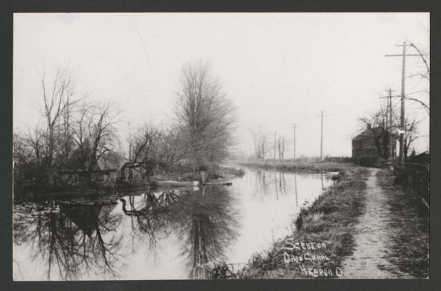
Photo: Chance Brockway historical photograph collection, Columbus Metropolitan Library, via DPLA, no known copyright restrictions · Wikimedia Commons
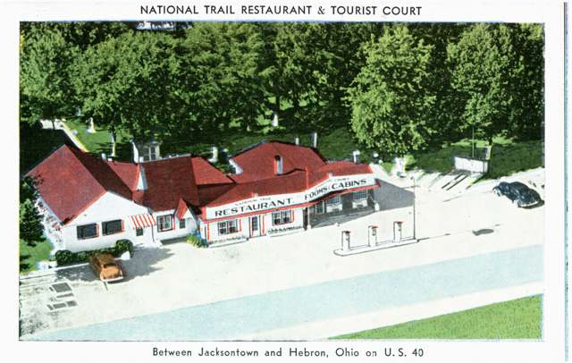
Photo: Columbus Metropolitan Library, via DPLA, no known copyright restrictions · Wikimedia Commons
Local history sources: hebronvillage.org · archive.org · archive.org · en.wikipedia.org · commons.wikimedia.org · commons.wikimedia.org
Water
Groundwater wells (4 wells) The water here
- Hebron Village82% of residentsGroundwater wells (4 wells)
- Licking County Harbor Hills14% of residentsGroundwater wells (4 wells)
- Buckeye Lake, Village Of3% of residentsGroundwater wells (4 wells)
- Roberts Trailer Park1% of residentsGroundwater wells (1 wells)
Its ZIP codes
Each ZIP code that touches Hebron, with the share of its residents who live here and the same headline figures as the ZIP page.
| ZIP | Share | Water | Radon | Home value | Schools | Flood |
|---|---|---|---|---|---|---|
| 43025 Hebron | 42% | Groundwater wells (4 wells) | 9.2 pCi/L average radon | Median year built 1980 | Lakewood Local · 3.5 stars overall | 14% of residents in the 1% floodplain |
The county
Licking County: 17 ZIP codes, 38 cities, villages and townships, 160,939 people.
Nearby places
Cite this page
Cite this page as:
Cracked Buckeye (Open Shower Co), "Hebron, Licking County", https://crackedbuckeye.com/place/hebron/, built 2026-09-16, accessed [date].
Machine-readable: /api/place/hebron.json (open JSON, CC BY 4.0 for the compilation; the underlying records keep their own terms) · How to cite · Report a correction · Built 2026-09-16