Local events in Hamilton Township, Warren County
3 events in the next 90 days from 1 public calendar. All local events in Hamilton Township, Warren County
Checked October 20; the events page is refreshed daily.
How Hamilton Township, Warren County began
Hamilton Township was organized on May 10, 1803, as one of Warren County's four original townships, and like many Ohio townships of the era it was named for Alexander Hamilton. It sits in the south-central part of the county along the Little Miami River, and its history runs through the river valley: Butterworth Station, built in 1820, served as both an Underground Railroad stop and a later Little Miami Railroad depot, and by the late 1800s the Peters Cartridge Company had built one of the nation's leading ammunition plants on the riverbank, supplying both World Wars before closing. The old rail corridor is now the Little Miami Scenic Trail, and the village of Maineville sits near the township's center alongside smaller communities such as Zoar, Cozaddale, and Fosters.
Settled October 1795 (Mounts' Station, probably the first settlement in the county south of the Little Miami), incorporated May 10, 1803 (one of the four original townships), by William Mounts and five other families at Mounts' Station.
Where the name comes from
The township was named for Alexander Hamilton, the same namesake used by several other Ohio townships (in Franklin, Jackson, and Lawrence counties, among others); no source gives a more specific local reason for the choice.
Before the town
Hamilton Township holds two of Warren County's most significant prehistoric sites, both near Morrow. Stubbs Earthworks is an Ohio Hopewell ceremonial center built beginning around 100 BCE and abandoned by about 500 CE: an earthen enclosure of circular and rectangular elements, a separate smaller circle, and a large timber circle 240 feet across built of 172 posts, radiocarbon-dated to AD 200-300, that was uncovered in a 2005 excavation by archaeologist Frank Cowan. Charles Whittlesey mapped the site in 1851; much of it was destroyed when Little Miami High School was built over part of it in 2000, though sections survive on the school grounds and it has been listed on the National Register of Historic Places since 1978. A few miles away, the Moar Mound and Village site (NRHP-listed 1976) pairs a well-preserved burial mound with an adjacent Late Woodland village; excavations there recovered multiple human burials and a range of grave goods, and the two contributing properties are considered directly associated with a single settlement. Beyond these prehistoric sites, no source found documents a historic-era (1700s) Native village, trail, or treaty line specific to Hamilton Township by name; the township lies within land ceded at the Treaty of Greenville (1795) that had been Shawnee and Miami territory before Ohio statehood.
Nations recorded here: Hopewell culture, Shawnee, Miami.
- Stubbs Earthworks (earthwork) — Morrow, Hamilton Township, on and near the campus of Little Miami High School, Ohio Hopewell, c. 100 BCE - AD 500 (timber circle radiocarbon-dated AD 200-300) (en.wikipedia.org)
- Moar Mound and Village (mound) — west of Morrow, Hamilton Township, Late Woodland (en.wikipedia.org)
Timeline
- — Ohio Hopewell people build the Stubbs Earthworks near Morrow, an enclosure complex that comes to include a 240-foot timber circle of 172 posts, radiocarbon-dated to AD 200-300.
- — Lieut. William McGuire enters Virginia Military warrant No. 520, 1,000 acres in the northeast of the township, on August 21; it is surveyed by Nathaniel Massie in January 1793, and the whole township lies in the Virginia Military lands.
- — William Mounts and five other families, including Thomas Forsha and Thomas Leonard, settle in October on land bought from Robert Todd and build cabins in a circle around a spring at Mounts' Station, probably the first settlement south of the Little Miami.
- — Theophilus Simonton, from North Carolina, settles in the fall near the Clermont County line, the first settler in the south; Joseph Hill follows in 1797, Samuel Hill in 1799 and Philip and Benjamin Hill in 1800.
- — The Peters Cartridge Company builds an ammunition factory in the township on the Little Miami River; it becomes one of the nation's leading cartridge manufacturers and supplies U.S. forces through both World Wars.
- — Hamilton Township is organized on May 10 as one of the four original townships of newly created Warren County.
- — Peter Wilson, backed by Gen. Lytle, sinks wells at salty springs half a mile south of Maineville about 1803 or 1804 and builds a furnace and kettles to make salt, the settlers' alternative to long trips for the barrel of salt.
- — On June 24 the eastern part of Hamilton Township is cut off to form Salem Township; the boundary is adjusted again on June 8, 1818, leaving a rectangle of about 36 square miles.
- — Settlers from Maine begin to arrive at the future Maineville, where Carr, a blacksmith famous for his axes, builds the first log house; Moses Dudley builds the first frame house and Dr. John Cottle builds the first brick house in 1821.
- — Butterworth Station is built along the Little Miami River, later serving as a stop on both the Underground Railroad and the Little Miami Railroad.
- — The first post office in the township opens at Hopkinsville; others follow at Dallasburg in 1848, Maineville in 1854, Foster's Crossing in 1859, Murdoch in 1866 and Cozaddale in 1871.
- — Maineville, the only incorporated village in the township, is incorporated; the first village election is held April 25, 1850, with Silas Dudley as first mayor.
- — Hoppe's Island and Loveland Park become popular riverside resort destinations reached by train along the Little Miami.
Stories
An ammunition town on the Little Miami
By the closing years of the nineteenth century the Peters Cartridge Company had built a sprawling factory complex on the Little Miami River in Hamilton Township, at what is now the Kings Mills/South Lebanon area of the river valley. The plant became one of the country's leading ammunition manufacturers, and through both World War I and World War II it supplied cartridges to American forces, employing large numbers of local residents including many women during wartime labor shortages. After the company's closure the riverside factory buildings stood for decades before being redeveloped for residential and commercial use, and the rail line that once served the plant became the Little Miami Scenic Trail, a bicycle and pedestrian corridor that now carries recreational traffic where freight once ran.
Mounts' Station
In October 1795, just two months after the Treaty of Greenville ended the Indian war, William Mounts, his wife and six children, and five other families, including Thomas Forsha and Thomas Leonard, built their cabins in a circle around a spring on land bought from Robert Todd and called their settlement Mounts' Station. Tradition holds it the very first settlement in the county south of the Little Miami. For another year they were alone: Theophilus Simonton, who came from North Carolina in the fall of 1796 to the southern end of the township, had no neighbors within the present limits except those at the Station. Many Virginians holding land warrants for the township had earlier come down the Ohio but found the Indians too hostile to settle, and had waited at Columbia and White's Station near Cincinnati.
Photographs
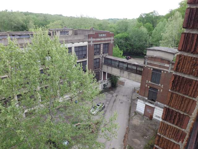
Photo: Ohio Historic Preservation Tax Credit program, via Wikimedia Commons, CC BY 2.0 · Wikimedia Commons
Local history sources: en.wikipedia.org · housetrends.com · en.wikipedia.org · en.wikipedia.org · commons.wikimedia.org · commons.wikimedia.org · en.wikipedia.org · en.wikipedia.org · archive.org
Water
17 groundwater wells drawing from the Little Miami River buried valley (sand-and-gravel) aquifer along the river near Maineville, in southern Warren County The water here
- Warren County76% of residentsWells in the Little Miami and Great Miami river valley aquifers
- Western Water Company12% of residentsLittle Miami River valley wells (51%) plus Cincinnati Ohio River water (49%)
- Clermont Public Water System4% of residentsWilliam H. Harsha Lake plus wells in the Little Miami River and Ohio River aquifers
- Morrow Village3% of residentsGroundwater wells (3 wells)
- Loveland City2% of residentsLocal wells (Betty Ray well field, sand & gravel aquifer)
- South Lebanon City1% of residentsOhio River (Miller Plant, ~88%) plus Great Miami Buried Valley Aquifer wells (~12%)
- Cincinnati Public Water System1% of residentsOhio River (Miller Plant, ~88%) plus Great Miami Buried Valley Aquifer wells (~12%)
- Warren Co. Socialville1% of residentsOhio River (Miller Plant, ~88%) plus Great Miami Buried Valley Aquifer wells (~12%)
Hospitals, fire stations and more
Inside Hamilton Township, Warren County's boundary: 1 nursing home, 2 fire and EMS stations, 2 high-hazard dams, 3 public schools, 1 private school, 5 poor-rated bridges, 1 public charging site, 2 Superfund sites, 1 Toxics Release Inventory facility and 7 spill cases. Press a pin or a name for its whole record and its source.
Nursing homes (1)
-
Otterbein at Maineville3 of 5 stars · Maineville
- Address
- 201 Marge Schott Way, Maineville, OH 45039
- Certified beds
- 60
- Residents on an average day
- 53
- Medicare overall rating
- 3 of 5 stars
- Health inspections
- 3 of 5 stars
- Staffing
- 4 of 5 stars
- Quality measures
- 4 of 5 stars
- Penalties since 2023
- 3 fines totalling $43,514 (latest 2025-04-03)
- Ownership
- Non profit - Corporation
- Chain
- OTTERBEIN SENIORLIFE
- Takes
- Medicare and Medicaid
- Phone
- (513) 309-5650
- Medicare ID
- 366393
- Map point
- the ZIP's center (the address did not geocode)
Medicare Care Compare ↗ CMS nursing home data (source) ↗ Street map and directions ↗
Source: CMS Care Compare nursing home provider and penalties files; Medicare star ratings run 1 to 5.
Fire and EMS stations (2)
-
Hamilton Township Fire and Rescue Station 76Maineville
- Address
- 7684 South State Highway 48, Maineville, OH 45039
- Coordinates
- 39.32312, -84.21988
USGS National Map structures (source) ↗ Street map and directions ↗
-
Hamilton Township Fire and Rescue Station 77Morrow
- Address
- 2000 East US Highway 22, Morrow, OH 45152
- Coordinates
- 39.35621, -84.17691
USGS National Map structures (source) ↗ Street map and directions ↗
Source: USGS National Map structures (most Ohio records last updated 2019 to 2022), checked against the Columbus and Cleveland station lists. The department that answers a call is set by jurisdiction and mutual aid, not by distance.
High-hazard dams (2)
-
Classicway Farm Lake Dam PoorTributary To Little Miami River · condition: poor
- Hazard class
- High: a failure would probably cost a life
- Condition
- Poor (assessed 04/18/2019)
- River or stream
- Tributary To Little Miami River
- Purpose
- Recreation
- Type
- Earth
- Height
- 24 ft
- Storage
- 73 acre-feet
- Completed
- 1965
- Owner type
- Private
- County
- Warren County
- Nearest town (NID)
- South Lebanon
- Last inspection
- 05/01/2024
- Emergency action plan
- No
- NID ID
- OH00532
National Inventory of Dams record ↗ National Inventory of Dams (source) ↗ Street map and directions ↗
-
Sunrise Lake DamTributary To Bear Run · condition: satisfactory
- Hazard class
- High: a failure would probably cost a life
- Condition
- Satisfactory (assessed 02/17/2025)
- River or stream
- Tributary To Bear Run
- Purpose
- Recreation
- Type
- Earth
- Height
- 54 ft
- Storage
- 257 acre-feet
- Completed
- 1931
- Owner type
- Private
- County
- Warren County
- Nearest town (NID)
- Foster
- Last inspection
- 05/01/2024
- Emergency action plan
- Yes
- NID ID
- OH00533
National Inventory of Dams record ↗ National Inventory of Dams (source) ↗ Street map and directions ↗
Source: U.S. Army Corps of Engineers National Inventory of Dams, August 2026. "High hazard" rates what a failure would cost downstream, not how likely one is; the condition is the state's assessment.
Public schools (3)
-
Little Miami High School4.5 of 5 stars · Morrow
- Address
- 3001 E US 22-3, Morrow, OH 45152
- School district
- Little Miami Local School District
- Kind (NCES)
- Regular School
- Students, 2023-24
- 1,519
- Teachers (full-time equivalent)
- 76.26
- Report card, 2025-26
- 4.5 of 5 stars
- Performance index
- 85.6%
- Four-year graduation rate
- 97.5%
- Ohio building IRN
- 021113
- NCES school ID
- 390504403948
NCES school record ↗ Ohio School Report Card ↗ Street map and directions ↗
-
Little Miami Middle School4.5 of 5 stars · Morrow
- Address
- 5290 Morrow Cozaddale Rd, Morrow, OH 45152
- School district
- Little Miami Local School District
- Kind (NCES)
- Regular School
- Students, 2023-24
- 1,312
- Teachers (full-time equivalent)
- 58.54
- Report card, 2025-26
- 4.5 of 5 stars
- Performance index
- 81.9%
- Ohio building IRN
- 021121
- NCES school ID
- 390504404302
NCES school record ↗ Ohio School Report Card ↗ Street map and directions ↗
-
Little Miami Primary School4 of 5 stars · Maineville
- Address
- 7247 Zoar Rd, Maineville, OH 45039
- School district
- Little Miami Local School District
- Kind (NCES)
- Regular School
- Students, 2023-24
- 886
- Teachers (full-time equivalent)
- 39.2
- Report card, 2025-26
- 4 of 5 stars
- Performance index
- 84%
- Ohio building IRN
- 009927
- NCES school ID
- 390504405492
NCES school record ↗ Ohio School Report Card ↗ Street map and directions ↗
Source: NCES EDGE public school locations 2024-25 and Common Core of Data 2023-24 (type, students, teachers); Ohio School Report Cards 2025-26 (Department of Education and Workforce), matched by name within the district.
Private schools (1)
-
Kings Point Christian AcademyPrivate, conservative Christian · Maineville
- Address
- 5600 S State Route 48, Maineville, OH 45039
- Kind
- conservative Christian
- Students, 2023-24
- 9
- Teachers (full-time equivalent)
- 2
- Students per teacher
- 4.5
- Phone
- (513) 494-1896
- NCES private school ID
- A2390417
Source: NCES Private School Survey 2023-24.
Bridges rated poor (5)
-
Grog Run Road over Grog RunPoor · built 1978
- Condition
- Poor: a deck, superstructure, substructure or culvert rated 4 or below on the 0 to 9 scale
- What it is
- Bridge
- Built
- 1978
- Length
- 12 ft
- Owner
- County
- Vehicles a day
- 351
- Coordinates
- 39.27349, -84.21350
National Bridge Inventory (source) ↗ Street map and directions ↗
-
Morrow-Cozaddale over Big Foot RunPoor · built 1977
- Condition
- Poor: a deck, superstructure, substructure or culvert rated 4 or below on the 0 to 9 scale
- What it is
- Bridge
- Built
- 1977
- Length
- 17 ft
- Owner
- County
- Vehicles a day
- 2,437
- Coordinates
- 39.35341, -84.16311
National Bridge Inventory (source) ↗ Street map and directions ↗
-
Morrow-Cozaddale over Branch of Big Foot RunPoor · built 1932
- Condition
- Poor: a deck, superstructure, substructure or culvert rated 4 or below on the 0 to 9 scale
- What it is
- Bridge
- Built
- 1932
- Length
- 8 ft
- Owner
- County
- Vehicles a day
- 2,215
- Coordinates
- 39.34852, -84.16017
National Bridge Inventory (source) ↗ Street map and directions ↗
-
Stephens Road over Br. of Bear RunPoor · built 1993
- Condition
- Poor: a deck, superstructure, substructure or culvert rated 4 or below on the 0 to 9 scale
- What it is
- Bridge
- Built
- 1993
- Length
- 15 ft
- Owner
- County
- Vehicles a day
- 2,227
- Coordinates
- 39.32660, -84.20340
National Bridge Inventory (source) ↗ Street map and directions ↗
-
US 22 over Bear RunPoor · built 1938
- Condition
- Poor: a deck, superstructure, substructure or culvert rated 4 or below on the 0 to 9 scale
- What it is
- Bridge
- Built
- 1938
- Length
- 20 ft
- Owner
- State
- Vehicles a day
- 16,452
- Coordinates
- 39.32425, -84.24619
National Bridge Inventory (source) ↗ Street map and directions ↗
Source: FHWA National Bridge Inventory 2025. "Poor" means one major part rated 4 or below on the 0 to 9 scale; it calls for repair, not closing, unless the state posts or closes the bridge.
Public EV charging (1)
-
Alexander Pointe - Building 22 Level 2 · Maineville
- Address
- 535 Willow Pond Blvd, Maineville, OH 45039
- Ports
- 2 Level 2
- Plugs
- J1772
- Network
- FLO
- Hours
- 24 hours daily
- Phone
- 888-356-8911
Station Locator (NREL) ↗ Alternative Fuels Data Center (source) ↗ Street map and directions ↗
Source: NREL Alternative Fuels Data Center station list (May 2026), public and open stations, the posts at one address counted as one site.
Superfund sites (2)
-
Kings Mills Military ReservationSuperfund program · Hamilton Township
- Address
- 6195 Striker Road, Hamilton Township, OH 45034
- County
- Warren County
- Status
- Superfund program site, not on the National Priorities List
- Federal facility
- Yes
- EPA program ID
- OH0001117878
- EPA registry ID
- 110009304092
EPA facility record ↗ EPA Facility Registry Service (source) ↗ Street map and directions ↗
-
Striker Road Drum SiteSuperfund program · Maineville
- Address
- 6451 Striker Rd, Maineville, OH 45039
- County
- Warren County
- Status
- Superfund program site, not on the National Priorities List
- EPA program ID
- OHN000510083
- EPA registry ID
- 110000617333
EPA facility record ↗ EPA Facility Registry Service (source) ↗ Street map and directions ↗
Source: EPA Facility Registry Service, Superfund (SEMS) and National Priorities List sites. Many program sites were assessed and needed no cleanup.
Facilities reporting toxic releases (1)
-
Sumco Phoenix CorpToxics Release Inventory · Maineville
- Address
- 537 Grandin Rd, Maineville, OH 45039
- County
- Warren County
- Status
- Reports to the Toxics Release Inventory (active)
- EPA program ID
- 45039CNCNN537GR
- EPA registry ID
- 110000392423
EPA facility record ↗ EPA Facility Registry Service (source) ↗ Street map and directions ↗
Source: EPA Facility Registry Service, Toxics Release Inventory reporters. Reporting a release is required of large users of listed chemicals; it is not by itself a violation.
Spills reported since 2021 (7)
-
Fuel Diesel / Diesel Fuel (Vehicle On Or Off Road)2025-08-23 · Miami Twp
- Reported
- 2025-08-23
- What spilled
- Fuel Diesel / Diesel Fuel (Vehicle On Or Off Road)
- Largest amount reported
- 9 gallons
- Where
- Miami Twp, Miami County
- Ohio EPA district office
- SWDO
- Ohio EPA case number
- 2508EPA0001437
Ohio EPA spill reports (source) ↗ Street map and directions ↗
-
Fuel Diesel / Diesel Fuel (Vehicle On Or Off Road)2025-03-17 · Hamilton Twp
- Reported
- 2025-03-17
- What spilled
- Fuel Diesel / Diesel Fuel (Vehicle On Or Off Road)
- Largest amount reported
- 25 gallons
- Where
- Hamilton Twp, Warren County
- Ohio EPA district office
- SWDO
- Ohio EPA case number
- 2503EPA0000382
Ohio EPA spill reports (source) ↗ Street map and directions ↗
-
Paint Nos / Lacquer (Not Specified)2024-12-20 · Hamilton Twp
- Reported
- 2024-12-20
- What spilled
- Paint Nos / Lacquer (Not Specified)
- Largest amount reported
- 5 gallons
- Where
- Hamilton Twp, Warren County
- Ohio EPA district office
- SWDO
- Ohio EPA case number
- 2412EPA0002047
Ohio EPA spill reports (source) ↗ Street map and directions ↗
-
Fuel Diesel / Diesel Fuel (Vehicle On Or Off Road) Reached water2024-03-08 · Hamilton Twp
- Reported
- 2024-03-08
- What spilled
- Fuel Diesel / Diesel Fuel (Vehicle On Or Off Road)
- Reached a waterway
- 99 - Unnamed
- Where
- Hamilton Twp, Warren County
- Ohio EPA district office
- SWDO
- Ohio EPA case number
- 2403EPA0000373
Ohio EPA spill reports (source) ↗ Street map and directions ↗
-
Oil Hydraulic Fluid(S) Reached water2023-04-20 · Hamilton Twp
- Reported
- 2023-04-20
- What spilled
- Oil Hydraulic Fluid(S)
- Reached a waterway
- Unnamed
- Where
- Hamilton Twp, Warren County
- Ohio EPA district office
- SWDO
- Ohio EPA case number
- 2304EPA0000635
Ohio EPA spill reports (source) ↗ Street map and directions ↗
-
Fuel Diesel / Diesel Fuel (Vehicle On Or Off Road)2023-02-22 · Hamilton Twp
- Reported
- 2023-02-22
- What spilled
- Fuel Diesel / Diesel Fuel (Vehicle On Or Off Road)
- Largest amount reported
- 15 gallons
- Where
- Hamilton Twp, Warren County
- Ohio EPA district office
- SWDO
- Ohio EPA case number
- 2302EPA0000274
Ohio EPA spill reports (source) ↗ Street map and directions ↗
-
Fuel Diesel / Diesel Fuel (Vehicle On Or Off Road)2022-08-18 · Hamilton Twp
- Reported
- 2022-08-18
- What spilled
- Fuel Diesel / Diesel Fuel (Vehicle On Or Off Road)
- Largest amount reported
- 75 gallons
- Where
- Hamilton Twp, Warren County
- Ohio EPA district office
- SWDO
- Ohio EPA case number
- 2208EPA0001257
Ohio EPA spill reports (source) ↗ Street map and directions ↗
Source: Ohio EPA emergency response spill reports, 2021 to September 2026, one point per case where Ohio EPA placed it. A report is what the caller or responder recorded; amounts are often blank or estimated.
Its ZIP codes
Each ZIP code that touches Hamilton Township, Warren County, with the share of its residents who live here and the same headline figures as the ZIP page.
Local government
Who holds office in Hamilton Township, Warren County, how its elections and ballot issues came out, and the state auditor's record.
Money issues on the ballot since 2018: 2 of 2 passed.
Ballot issues
| Date | Issue | For | Against | Result |
|---|---|---|---|---|
| 2018-11-06 | Issue 8: 8 Hamilton Twp Tax Levy Police | 8,694 | 3,013 | Passed (74.26% for) |
| 2018-11-06 | Issue 9: 9 Hamilton Twp Tax Levy Streets | 6,864 | 4,827 | Passed (58.71% for) |
| 2015-11-03 | Issue 5: 5 Hamilton Twp Police Renewal 1 mill | 5,606 | 2,131 | Passed (72.46% for) |
Elections for office
| Date | Office | Candidates and votes |
|---|---|---|
| 2017-11-07 | Township Trustees | Joe Rozzi 2,975, 28.23%; Darryl Cordrey 2,110, 20.02%; David Wallace 1,775, 16.84%; Nathan Myers 1,485, 14.09%; Kim Lukens 1,280, 12.15%; Cadi Kelly 595, 5.65%; Roxan Tarnowski 319, 3.03% |
| 2015-11-03 | Township Trustee | Joe Walker 3,220, 47.35%; Gene Duvelius 2,511, 36.93%; Joshua Bibee 1,069, 15.72% |
| 2015-11-03 | Fiscal Officer | James D. Hunter 3,711, 58.82%; Russell Holman 2,598, 41.18% |
Winners in bold. Results from the county board of elections' official canvass unless marked.
Auditor of State record
- Fiscal emergency: declared 2014-04-09, released 2015-10-01. source
- Financial Audit, 2024, released 2025-10-21
- Financial Audit, 2023, released 2025-01-30
The county
Warren County: 12 ZIP codes, 24 cities, villages and townships, 222,825 people.
Nearby places
Quick answers
What county is Hamilton Township, Ohio in?
Hamilton Township, Warren County is a township in Warren County, Ohio, with 26,276 residents.
When was Hamilton Township, Ohio founded?
Hamilton Township, Warren County was settled October 1795 (Mounts' Station, probably the first settlement in the county south of the Little Miami); incorporated May 10, 1803 (one of the four original townships). Founders on record: William Mounts and five other families at Mounts' Station. Source
How did Hamilton Township, Ohio get its name?
The township was named for Alexander Hamilton, the same namesake used by several other Ohio townships (in Franklin, Jackson, and Lawrence counties, among others); no source gives a more specific local reason for the choice. Source
What ZIP code is Hamilton Township, Ohio?
Hamilton Township, Warren County is served by ZIP codes 45039, 45152, 45140 and 45122; 45039 holds the largest share of its residents.
Where does Hamilton Township, Ohio get its water?
The main water source for Hamilton Township, Warren County (Warren County): 17 groundwater wells drawing from the Little Miami River buried valley (sand-and-gravel) aquifer along the river near Maineville, in southern Warren County.
Cite this page
Cite this page as:
Cracked Buckeye, "Hamilton Township, Warren County", https://crackedbuckeye.com/place/hamilton-township-warren-county/, built 2026-10-31, accessed [date].
How to cite · Report a correction · Built 2026-10-31
