Local events in Morrow
12 events in the next 90 days from 1 public calendar. All local events in Morrow
Checked October 20; the events page is refreshed daily.
How Morrow began
Morrow was platted in 1844-45 in Salem Township, Warren County, where the Little Miami Railroad reached a grist mill on James Miranda's farm at the confluence of Todd's Fork and the Little Miami River, and it was named for Jeremiah Morrow, Ohio's ninth governor and the railroad's first (unpaid) president. The railroad, chartered in 1836 and running scheduled service from Cincinnati by August 1845, made Morrow a regional rail and stagecoach hub, and from 1853, under an agreement with the Columbus and Xenia Railroad, the two roads were operated as a single line from Cincinnati to the state capital. The village stayed a modest river and rail town through the twentieth century, growing from 459 residents in 1850 to a mid-century peak, and has grown sharply again in recent years (2,049 residents in 2020, up 72.5% from 2010). Its present water utility, the customer-owned Western Water Company founded in 1976, drew national attention in 2023-24 when a $7.5 million USDA loan to expand Morrow's treatment plant for PFAS removal was announced in the village.
Platted 1844-1845, by Little Miami Railroad Company, building to a grist mill on James Miranda's farm.
Where the name comes from
Named for Jeremiah Morrow (1771-1852), Ohio's ninth governor, who served without pay as the first president of the Little Miami Railroad Company from its 1836 incorporation until 1845, the year the line reached and the village that took his name was platted.
Before the town
No source found a Native American village, trail, mound, or documented encounter specifically inside present Morrow. As at Waynesville, the wider context is documented: Morrow sits on the Little Miami River at its confluence with Todd's Fork, a valley the Shawnee and Miami used for hunting and travel before the 1795 Treaty of Greenville ceded the area to the United States, and the same valley (Warren County) holds Fort Ancient, the large Hopewell-era hilltop earthwork near Lebanon - a regional landmark, not a Morrow-specific site.
Nations recorded here: Shawnee, Miami, Hopewell culture.
Timeline
- — The Treaty of Greenville cedes the Little Miami valley, including the future site of Morrow, to the United States.
- — The Little Miami Railroad is incorporated, with Jeremiah Morrow, former Ohio governor, serving as its first, unpaid president.
- — Little Miami Railroad track reaches a grist mill on James Miranda's farm at the confluence of the Little Miami River and Todd's Fork, the site that becomes Morrow.
- — The village is platted and named for Jeremiah Morrow; a post office opens the same year.
- — The Little Miami Railroad begins scheduled service between Cincinnati and Xenia, passing through Morrow.
- — On November 30, the Little Miami Railroad and the Columbus and Xenia Railroad agree to operate their roads as a single line between Cincinnati and Columbus through Morrow; the arrangement was dissolved in 1868 when the Little Miami leased the Columbus and Xenia for 99 years.
- — Morrow's population is recorded at 459.
- — Morrow's population peaks at 1,477 before a decades-long decline.
- — Western Water Company is founded as a non-profit, customer-owned rural water system serving parts of Brown, Clermont, Clinton and Warren counties, including Morrow, financed by USDA Rural Development.
- — The census records 2,049 Morrow residents, a 72.5% increase over 2010, reversing decades of decline.
- — USDA Rural Development obligates a $7.5 million Water and Waste Disposal loan to expand the Morrow treatment plant for PFAS removal.
- — USDA Rural Development's Ohio state director and Western Water Company officials mark the loan in Morrow; the plant expansion, serving about 50,000 rural residents in southwest Ohio, is scheduled to run 2025-2026.
Stories
A governor's railroad names its own town
Jeremiah Morrow never lived in the village that bears his name. He had already served two terms as Ohio's governor (1822-1826) and represented the state in Congress and the U.S. Senate before, in his mid-sixties, he took the unpaid presidency of the newly chartered Little Miami Railroad Company in 1836 - Ohio's first railroad out of Cincinnati. Construction crept north along the Little Miami valley through the early 1840s, reaching a grist mill on James Miranda's farm at the mouth of Todd's Fork by 1844. When the village that grew up around that rail stop was platted in 1845, it took the name of the railroad's elderly first president rather than its founder's or a settler's, one of several Ohio towns along the line named for men who built it rather than men who lived in it.
From Cincinnati's first railroad to a rail-trail crossing
The Little Miami Railroad reached Morrow in 1844 and was running scheduled trains between Cincinnati and Xenia by August 1845; from 1853 it was operated as a single line with the Columbus and Xenia Railroad between Ohio's largest city and its capital, with Morrow as a stop along the way. The railroad's grade through the village has since become the Little Miami Scenic Trail, a rail-trail that crosses Todd's Fork on the old railroad bridge just south of downtown - a bridge that once carried freight and passengers between Cincinnati and Columbus and now carries hikers and cyclists over the same stream that once powered the Miranda grist mill that put Morrow on the map.
A rural water company and a PFAS fix
Western Water Company, the customer-owned rural system founded in 1976 to serve parts of Brown, Clermont, Clinton and Warren counties, tested its supply under Ohio EPA's PFAS Sampling Initiative in 2021 and found the "forever chemicals" present, though below the state's action level. Rather than wait, the company sought federal help, and in 2023 USDA Rural Development obligated a $7.5 million Water and Waste Disposal loan to expand the treatment plant serving Morrow specifically to remove PFAS. On April 25, 2024, USDA's Ohio state director and Western Water officials gathered in Morrow to mark the award, with the expansion - serving an estimated 50,000 rural southwest Ohio customers - scheduled to run from 2025 into 2026.
Photographs
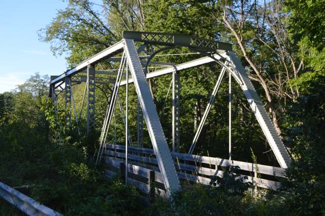
Photo: Nyttend, public domain · Wikimedia Commons
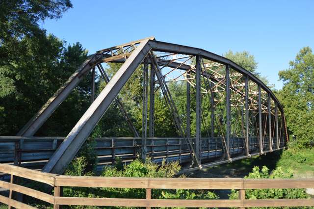
Photo: Nyttend, public domain · Wikimedia Commons
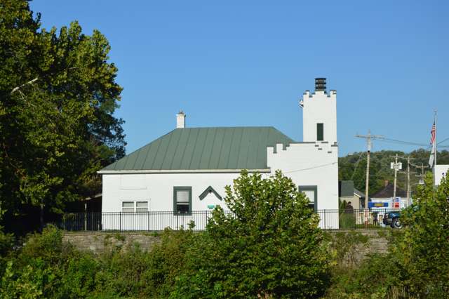
Photo: Nyttend, public domain · Wikimedia Commons
Photo: Mark McCann, USDA Media, public domain · Wikimedia Commons
Local history sources: en.wikipedia.org · morrowoh.com · buckeyetrail.org · warren.ohgenweb.org · en.wikipedia.org · britannica.com · commons.wikimedia.org · commons.wikimedia.org · commons.wikimedia.org · commons.wikimedia.org · commons.wikimedia.org · villageofwaynesville.org · web.archive.org
Water
Ohio River intake at the plant's riverfront on Kellogg Ave in the California neighborhood, east Cincinnati The water here
- Western Water Company56% of residentsLittle Miami River valley wells (51%) plus Cincinnati Ohio River water (49%)
- Warren County22% of residentsWells in the Little Miami and Great Miami river valley aquifers
- Morrow Village17% of residentsGroundwater wells (3 wells)
- South Lebanon City4% of residentsOhio River (Miller Plant, ~88%) plus Great Miami Buried Valley Aquifer wells (~12%)
Hospitals, fire stations and more
Inside Morrow's boundary: 1 nursing home, 1 fire or EMS station, 2 public schools, 1 library, 1 police station and 2 spill cases. Press a pin or a name for its whole record and its source.
Nursing homes (1)
-
Pine Ridge Skilled Nursing and Rehab3 of 5 stars · Morrow
- Address
- 463 East Pike Street, Morrow, OH 45152
- Certified beds
- 50
- Residents on an average day
- 48
- Medicare overall rating
- 3 of 5 stars
- Health inspections
- 2 of 5 stars
- Staffing
- 2 of 5 stars
- Quality measures
- 5 of 5 stars
- Penalties since 2023
- none
- Ownership
- For profit - Limited Liability company
- Chain
- HILLSTONE HEALTHCARE
- Takes
- Medicare and Medicaid
- Phone
- (513) 899-2801
- Medicare ID
- 365878
Medicare Care Compare ↗ CMS nursing home data (source) ↗ Street map and directions ↗
Source: CMS Care Compare nursing home provider and penalties files; Medicare star ratings run 1 to 5.
Fire and EMS stations (1)
-
Salem / Morrow Fire Department Station 71Morrow
- Address
- 5270 East US Highway 22, Morrow, OH 45152
- Coordinates
- 39.35723, -84.11294
USGS National Map structures (source) ↗ Street map and directions ↗
Source: USGS National Map structures (most Ohio records last updated 2019 to 2022), checked against the Columbus and Cleveland station lists. The department that answers a call is set by jurisdiction and mutual aid, not by distance.
Public schools (2)
-
Little Miami Early Childhood Center4 of 5 stars · Morrow
- Address
- 609 Welch Rd, Morrow, OH 45152
- School district
- Little Miami Local School District
- Kind (NCES)
- Regular School
- Students, 2023-24
- 945
- Teachers (full-time equivalent)
- 39.4
- Report card, 2025-26
- 4 of 5 stars
- Ohio building IRN
- 019447
- NCES school ID
- 390504406170
NCES school record ↗ Ohio School Report Card ↗ Street map and directions ↗
-
Little Miami Elementary School3.5 of 5 stars · Morrow
- Address
- 605 Welch Rd, Morrow, OH 45152
- School district
- Little Miami Local School District
- Kind (NCES)
- Regular School
- Students, 2023-24
- 855
- Teachers (full-time equivalent)
- 42
- Report card, 2025-26
- 3.5 of 5 stars
- Performance index
- 83.6%
- Ohio building IRN
- 138859
- NCES school ID
- 390504403548
NCES school record ↗ Ohio School Report Card ↗ Street map and directions ↗
Source: NCES EDGE public school locations 2024-25 and Common Core of Data 2023-24 (type, students, teachers); Ohio School Report Cards 2025-26 (Department of Education and Workforce), matched by name within the district.
Public libraries (1)
-
Salem Township Public LibraryCentral library · Morrow
- Address
- 535 W. Pike St., Morrow, OH 45152
- What it is
- Central library
- Library system
- Salem Township Public Library
- Open
- 2,236 hours a year, 52 weeks
- Building
- 10,000 sq ft
- System's visits, FY2024
- 35,984
- People the system serves
- 42,715
- Phone
- (513) 899-2588
IMLS Public Libraries Survey (source) ↗ Street map and directions ↗
Source: IMLS Public Libraries Survey FY2024 (outlets and their systems). Any Ohio resident can get a free card at any Ohio public library.
Police stations (1)
-
Morrow Police DepartmentMorrow
- Address
- 150 East Pike Street, Morrow, OH 45152
- Coordinates
- 39.35454, -84.12951
USGS National Map structures (source) ↗ Street map and directions ↗
Source: USGS National Map structures, police stations, corrected and completed by hand (September 2026). The department that answers a call is set by jurisdiction, not by distance.
Spills reported since 2021 (2)
-
Sheen Rainbow / Hydrocarbon Reached water2022-03-21 · Morrow
- Reported
- 2022-03-21
- What spilled
- Sheen Rainbow / Hydrocarbon
- Reached a waterway
- 99 - Unnamed
- Where
- Morrow, Warren County
- Ohio EPA district office
- SWDO
- Ohio EPA case number
- 2203EPA0000378
Ohio EPA spill reports (source) ↗ Street map and directions ↗
-
Sheen Rainbow / Hydrocarbon Reached water2022-03-07 · Morrow
- Reported
- 2022-03-07
- What spilled
- Sheen Rainbow / Hydrocarbon
- Reached a waterway
- 83 - Little Miami River
- Where
- Morrow, Warren County
- Ohio EPA district office
- SWDO
- Ohio EPA case number
- 2203EPA0000291
Ohio EPA spill reports (source) ↗ Street map and directions ↗
Source: Ohio EPA emergency response spill reports, 2021 to September 2026, one point per case where Ohio EPA placed it. A report is what the caller or responder recorded; amounts are often blank or estimated.
Its ZIP codes
Each ZIP code that touches Morrow, with the share of its residents who live here and the same headline figures as the ZIP page.
| ZIP | Share | Water | Radon | Home value | Schools | Flood |
|---|---|---|---|---|---|---|
| 45152 Hamilton Township and Morrow | 15% | Ohio River intake at the plant's riverfront on Kellogg Ave in the California neighborhood, east Cincinnati | 5.9 pCi/L average radon | Appraisal records without year built | Little Miami Local · 4.5 stars overall | 7.4% of residents in the 1% floodplain |
Local government
Who holds office in Morrow, how its elections and ballot issues came out, and the state auditor's record.
Elections for office
| Date | Office | Candidates and votes |
|---|---|---|
| 2017-11-07 | Member of Council | Rebecca Isaacs-Niemesh 171, 31.2%; Michael McKeehan 153, 27.92%; Clarissa Walls-Parker 117, 21.35%; Paul Zorn 43, 7.85%; Johnny Salyers 32, 5.84%; Kathryne Issaacs 17, 3.1% |
| 2015-11-03 | Member of Council | Kiley Dane 208, 27.01%; Bill Thompson 208, 27.01%; Luanne Cain 131, 17.01%; Randy Osborn 124, 16.1%; David A. Ducker 99, 12.86% |
| 2015-11-03 | Mayor | York Bryant 243, 52.71%; Judy Neal 218, 47.29% |
Winners in bold. Results from the county board of elections' official canvass unless marked.
Auditor of State record
- Fiscal watch: declared 2007-11-08, released 2009-09-03. source
The county
Warren County: 12 ZIP codes, 24 cities, villages and townships, 222,825 people.
Nearby places
Rain and snow
How much has actually fallen on Morrow, day by day, from 1893 to now. Daily totals, not averages.
- rain, last 30 days
- 0.94 in
- 2026-09-30 to 2026-10-29
- rain so far in 2026
- 45.1 in
- 6.0 in above normal for the date
- snow so far in 2026
- 17.7 in
- a normal year brings 17.4 in
- a normal year
- 45.9 in
- average of 30 years, 1991-2020
| Month | Rain (in) | Snow (in) | Days counted |
|---|---|---|---|
| October 2026 | 0.94 | — | 29 |
| September 2026 | 7.08 | — | 30 |
| August 2026 | 6.91 | — | 31 |
| July 2026 | 3.79 | — | 31 |
| June 2026 | 4.86 | — | 30 |
| May 2026 | 6.44 | — | 31 |
| April 2026 | 4.11 | — | 30 |
| March 2026 | 7.85 | 0.5 | 31 |
| February 2026 | 1.37 | 5.2 | 28 |
| January 2026 | 1.72 | 12.0 | 31 |
| December 2025 | 2.72 | 11.4 | 31 |
| November 2025 | 3.82 | 3.2 | 30 |
| Wettest year | 2011 — 64.5 in |
|---|---|
| Driest year | 1934 — 21.6 in |
| Snowiest year | 1977 — 50.5 in |
| Wettest day on record | 6 October 1910 — 5.46 in |
| Heaviest snowfall in a day | 23 December 2004 — 12.52 in |
| Deepest snow on the ground | 25 January 1894 — 20.00 in |
Estimated, not measured. No rain gauge has ever stood inside Morrow, so every figure here is worked out from the gauges around it - the nearest ones weighted most. Treat them as close estimates rather than readings.
48,635 days of records, 1893-01-01 to 2026-10-29. Source: NOAA NCEI GHCN-Daily, 3,240 gauges in and around Ohio. A day is "gauged" when a gauge standing inside the boundary reported it, and the value is the mean of those gauges. Otherwise it is interpolated by inverse distance from every gauge reporting within 50 miles. Nothing is carried forward, back-filled or smoothed. Against NOAA nClimDiv county monthly precipitation over 136,848 complete county-months (checked 2026-10-31): correlation 0.9515, median absolute difference 0.217 in a month. Built 2026-10-31 from the Cracked Buckeye precipitation archive. Snow is the softer number — snowfall is measured by hand with a ruler, no agency publishes a gridded county snowfall series, and blowing snow defeats every observer.
Environmental permits and filings
What Ohio EPA has on file for Morrow: permits, inspections, violations, cleanups and the state loans behind sewer and water work. Every line links to the agency's own document.
- facilities and sites on file
- 2
- those placed on the map inside Morrow
| Program | Facilities and sites |
|---|---|
| Public drinking water | 1 |
| Source-water protection | 1 |
| Date | Facility or site | What |
|---|---|---|
| MORROW VILLAGE PWS | Public drinking water compliance letter | |
| MORROW VILLAGE PWS | Public drinking water inspection | |
| MORROW VILLAGE PWS | Public drinking water notice of violation | |
| MORROW VILLAGE PWS | Public drinking water report | |
| MORROW VILLAGE PWS | Public drinking water notice of violation | |
| MORROW VILLAGE PWS | Public drinking water inspection | |
| MORROW VILLAGE PWS | Public drinking water inspection | |
| MORROW VILLAGE PWS | Public drinking water compliance letter | |
| MORROW VILLAGE PWS | Public drinking water notice of violation | |
| MORROW VILLAGE PWS | Public drinking water compliance letter | |
| MORROW VILLAGE PWS | Public drinking water notice of violation | |
| MORROW VILLAGE PWS | Public drinking water notice of violation | |
| MORROW VILLAGE PWS | Public drinking water notice of violation | |
| MORROW VILLAGE PWS | Public drinking water plan | |
| MORROW VILLAGE PWS | Public drinking water plan | |
| MORROW VILLAGE PWS | Public drinking water report | |
| MORROW VILLAGE PWS | Public drinking water plan | |
| MORROW VILLAGE PWS | Public drinking water plan | |
| MORROW VILLAGE PWS | Public drinking water warning letter | |
| MORROW VILLAGE PWS | Public drinking water plan | |
| MORROW VILLAGE PWS | Public drinking water notice of violation | |
| MORROW VILLAGE PWS | Public drinking water compliance letter | |
| MORROW VILLAGE PWS | Public drinking water compliance letter | |
| MORROW VILLAGE PWS | Public drinking water compliance letter | |
| MORROW VILLAGE PWS | Public drinking water report |
Source: Ohio EPA eDocument portal (edocpub.epa.ohio.gov), indexed 2026-10-14. Facilities are placed on the map from Ohio EPA's own map layers, EPA's Facility Registry, coordinates written in the filings, or a geocoded street address. A permit filed under a private person's name (most are household septic systems) is counted but never named, placed or linked; licenses for individual workers and open-burning notices are left out entirely.
Quick answers
What county is Morrow, Ohio in?
Morrow is a village in Warren County, Ohio, with 2,049 residents.
When was Morrow, Ohio founded?
Morrow was laid out 1844-1845. Founders on record: Little Miami Railroad Company, building to a grist mill on James Miranda's farm. Source
How did Morrow, Ohio get its name?
Named for Jeremiah Morrow (1771-1852), Ohio's ninth governor, who served without pay as the first president of the Little Miami Railroad Company from its 1836 incorporation until 1845, the year the line reached and the village that took his name was platted. Source
What ZIP code is Morrow, Ohio?
Most of Morrow is in ZIP code 45152.
Where does Morrow, Ohio get its water?
The main water source for Morrow (Western Water Company): Ohio River intake at the plant's riverfront on Kellogg Ave in the California neighborhood, east Cincinnati.
Cite this page
Cite this page as:
Cracked Buckeye, "Morrow, Warren County", https://crackedbuckeye.com/place/morrow/, built 2026-10-31, accessed [date].
How to cite · Report a correction · Built 2026-10-31
