Local events in Augusta Township, Carroll County
Nothing is posted for Augusta Township itself yet; here is what is on within 20 miles. All local events in Augusta Township, Carroll County
Know a calendar we should watch? Send the link
Checked October 20; the events page is refreshed daily.
How Augusta Township, Carroll County began
Augusta Township, in the northern part of Carroll County, was part of Columbiana County until Carroll County was created in 1832-33, and is the only township named Augusta anywhere in Ohio. Jacob Brown entered 320 acres here in 1809 and platted the village of Augusta in 1811, building a log cabin near what is now a maple grove and selling the settlement's first lot the same year; by the 1890s the village held about seventy buildings. The township has no incorporated municipality today, but it holds two of Carroll County's National Register listings -- the stone Herrington Bethel Church and the brick Henry and Mary Pottorf House and Farmstead -- both survivors of the township's early-19th-century settlement period.
Settled 1809 (Jacob Brown enters 320 acres), platted 1811 (Augusta village), incorporated 1832-33 (transferred from Columbiana County into newly formed Carroll County), by Jacob Brown.
Where the name comes from
Named for the village of Augusta platted within it in 1811; Augusta Township is the only township of that name in Ohio.
Before the town
No source reviewed records a specific Native American village, mound or documented encounter within Augusta Township. The 1921 county history describes the pre-settlement landscape only in general terms ('all was wild and uncultivated ... giant trees'), with no named Native site. Like the rest of Carroll County, the land was ceded by the Lenape (Delaware), Wyandot and allied nations under the Treaty of Greenville (1795) and subsequent treaties before Jacob Brown's 1809 land entry.
Nations recorded here: Lenape (Delaware), Wyandot.
Timeline
- — Jacob Brown enters 320 acres of land in what becomes Augusta Township and builds a log cabin near the site of a later maple grove.
- — Brown plats the village of Augusta and sells its first lot to a Mr. Rigglesworth.
- — The Pottorf Hotel, one of the village's first structures, is built.
- — Carroll County is organized, transferring Augusta Township out of Columbiana County.
- — The township's first schoolhouse is built; it is rebuilt in 1853 and again in 1888.
- — The township's first church, for the Bible Christian congregation, is organized; it is rebuilt in 1881.
- — The John Herrington House and Herrington Bethel Church, at 4070 Arbor Rd. NE, are listed on the National Register of Historic Places on January 19.
- — The Henry and Mary Pottorf House and Farmstead, at 4071 Meter Rd., are listed on the National Register of Historic Places on March 9.
Stories
A village that peaked before the railroad came
Augusta grew steadily in its first decades: after Jacob Brown platted it in 1811 and sold off his remaining land to George P. S. Manful the following year, storekeepers, a blacksmith, a doctor, a shoemaker and a tailor set up along its streets, and by 1892 the village counted about seventy buildings. Its decline was not gradual decay but a single missed connection -- when railroads were built through Carroll County in the later 19th century, they bypassed Augusta for nearby stations, and Augusta Township's population fell from 1,021 in 1890 to 866 by 1910 as trade drained toward the rail towns.
The stone church on Arbor Road
The Herrington Bethel Church, a stone church on Arbor Road NE built by the Herrington family in the township's settlement era, was listed on the National Register of Historic Places in January 1983 alongside the John Herrington House. It stands today as one of two surviving National Register properties in Augusta Township, both dating to the same first generation of settlement that produced Jacob Brown's village a few miles away.
Photographs
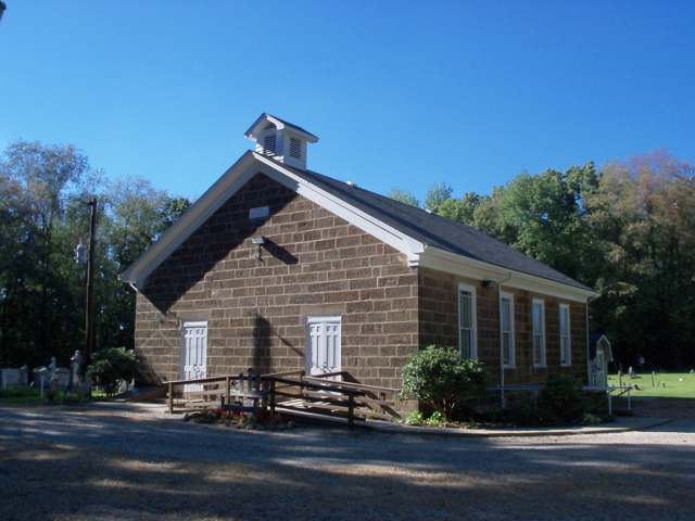
Photo: Roseohioresident, Wikimedia Commons, public domain · Wikimedia Commons
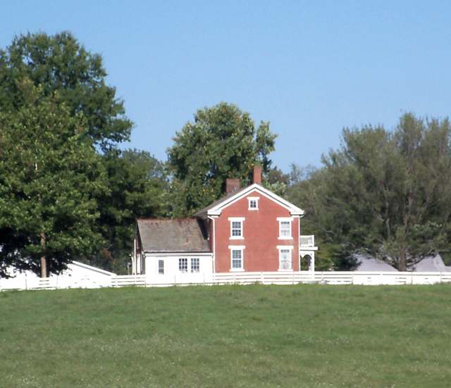
Photo: Roseohioresident, Wikimedia Commons, public domain · Wikimedia Commons
Local history sources: ohiogenealogyexpress.com · en.wikipedia.org · en.wikipedia.org · en.wikipedia.org
Historic places
2 places in Augusta Township, Carroll County on the National Register of Historic Places. Press a pin or a name for its whole record.
-
Herrington, John, House and Herrington Bethel ChurchBuilding · Mechanicstown · listed 1983
- Address
- 4070 Arbor Rd. NE
- Where
- Mechanicstown, Carroll County · ZIP 44651
- What it is
- Building
- Listed on the National Register
- 1983
- NRIS reference number
- 83001949
- Coordinates
- 40.64922, -81.01259
National Register file (NPS) ↗ Search Wikipedia ↗ Street map and directions ↗ On the Cracked Buckeye map
-
Pottorf, Henry and Mary, House and FarmsteadBuilding · Mechanicstown · listed 1995
- Address
- 4071 Meter Rd.
- Where
- Mechanicstown, Carroll County · ZIP 44651
- What it is
- Building
- Listed on the National Register
- 1995
- NRIS reference number
- 95000171
- Coordinates
- 40.66291, -81.00786
National Register file (NPS) ↗ Search Wikipedia ↗ Street map and directions ↗ On the Cracked Buckeye map
Source: National Park Service, National Register of Historic Places point file. The listing year is shown where NPS's certification date agrees with the listing's reference number. Listing recognizes significance; it does not restrict a private owner.
Water
Mostly private wells The water here
- Minerva Village53% of residentsGroundwater wells (3 wells)
- Carrollton Village44% of residentsGroundwater wells (10 wells)
- Premier Park Estates Llc2% of residentsGroundwater wells (1 wells)
- Rockwood Park1% of residentsGroundwater wells (2 wells)
- Skyland Hills MHP0% of residentsGroundwater wells (2 wells)
- Columbiana County-county Home Rd0% of residentsEast Cold Run Reservoir & Spring Valley Reservoir (Cold Run Creek)
Hospitals, fire stations and more
Inside Augusta Township, Carroll County's boundary: 1 poor-rated bridge, 29 shale and injection wells and 15 spill cases. Press a pin or a name for its whole record and its source.
Bridges rated poor (1)
-
CO Rd 14 over Still Fork Cr. Bn18Poor · built 1950
- Condition
- Poor: a deck, superstructure, substructure or culvert rated 4 or below on the 0 to 9 scale
- What it is
- Bridge
- Built
- 1950
- Length
- 21 ft
- Owner
- County
- Vehicles a day
- 88
- Coordinates
- 40.69873, -81.06915
National Bridge Inventory (source) ↗ Street map and directions ↗
Source: FHWA National Bridge Inventory 2025. "Poor" means one major part rated 4 or below on the 0 to 9 scale; it calls for repair, not closing, unless the state posts or closes the bridge.
Shale and injection wells (29)
-
Hawk 2-15-5 1HUtica shale well
- What it is
- Utica shale well
- Drilled sideways
- Yes
- Operator
- Eog Ohio, Llc
- County
- Carroll County
- API well number
- 34019222470000
- Coordinates
- 40.71360, -81.00470
ODNR oil and gas wells (source) ↗ Street map and directions ↗
The point is the surface well head (the pad); a horizontal well runs a mile or more underground from it.
-
Hawk 2-15-5 8HUtica shale well
- What it is
- Utica shale well
- Drilled sideways
- Yes
- Operator
- Eog Ohio, Llc
- County
- Carroll County
- API well number
- 34019222200000
- Coordinates
- 40.71352, -81.00461
ODNR oil and gas wells (source) ↗ Street map and directions ↗
The point is the surface well head (the pad); a horizontal well runs a mile or more underground from it.
-
Hutchison 33-15-5 1HUtica shale well
- What it is
- Utica shale well
- Drilled sideways
- Yes
- Operator
- Eog Ohio, Llc
- County
- Carroll County
- API well number
- 34019224760000
- Coordinates
- 40.65056, -81.03771
ODNR oil and gas wells (source) ↗ Street map and directions ↗
The point is the surface well head (the pad); a horizontal well runs a mile or more underground from it.
-
Hutchison 33-15-5 3HUtica shale well
- What it is
- Utica shale well
- Drilled sideways
- Yes
- Operator
- Eog Ohio, Llc
- County
- Carroll County
- API well number
- 34019224800000
- Coordinates
- 40.65056, -81.03764
ODNR oil and gas wells (source) ↗ Street map and directions ↗
The point is the surface well head (the pad); a horizontal well runs a mile or more underground from it.
-
Hutchison 33-15-5 5HUtica shale well
- What it is
- Utica shale well
- Drilled sideways
- Yes
- Operator
- Eog Ohio, Llc
- County
- Carroll County
- API well number
- 34019224820000
- Coordinates
- 40.65055, -81.03756
ODNR oil and gas wells (source) ↗ Street map and directions ↗
The point is the surface well head (the pad); a horizontal well runs a mile or more underground from it.
-
Jd Cr Aug 1HUtica shale well
- What it is
- Utica shale well
- Drilled sideways
- Yes
- Operator
- Eog Ohio, Llc
- County
- Carroll County
- API well number
- 34019227630000
- Coordinates
- 40.70574, -81.01290
ODNR oil and gas wells (source) ↗ Street map and directions ↗
The point is the surface well head (the pad); a horizontal well runs a mile or more underground from it.
-
Jd Cr Aug 205HUtica shale well
- What it is
- Utica shale well
- Drilled sideways
- Yes
- Operator
- Eog Ohio, Llc
- County
- Carroll County
- API well number
- 34019227660000
- Coordinates
- 40.70591, -81.01291
ODNR oil and gas wells (source) ↗ Street map and directions ↗
The point is the surface well head (the pad); a horizontal well runs a mile or more underground from it.
-
Jd Cr Aug 3HUtica shale well
- What it is
- Utica shale well
- Drilled sideways
- Yes
- Operator
- Eog Ohio, Llc
- County
- Carroll County
- API well number
- 34019227640000
- Coordinates
- 40.70580, -81.01290
ODNR oil and gas wells (source) ↗ Street map and directions ↗
The point is the surface well head (the pad); a horizontal well runs a mile or more underground from it.
-
Jd Cr Aug 5HUtica shale well
- What it is
- Utica shale well
- Drilled sideways
- Yes
- Operator
- Eog Ohio, Llc
- County
- Carroll County
- API well number
- 34019227650000
- Coordinates
- 40.70585, -81.01291
ODNR oil and gas wells (source) ↗ Street map and directions ↗
The point is the surface well head (the pad); a horizontal well runs a mile or more underground from it.
-
Jeffery 2-15-5 10HUtica shale well
- What it is
- Utica shale well
- Drilled sideways
- Yes
- Operator
- Eog Ohio, Llc
- County
- Carroll County
- API well number
- 34019223310000
- Coordinates
- 40.71909, -80.99525
ODNR oil and gas wells (source) ↗ Street map and directions ↗
The point is the surface well head (the pad); a horizontal well runs a mile or more underground from it.
-
Jeffery 2-15-5 5HUtica shale well
- What it is
- Utica shale well
- Drilled sideways
- Yes
- Operator
- Eog Ohio, Llc
- County
- Carroll County
- API well number
- 34019222770000
- Coordinates
- 40.71916, -80.99528
ODNR oil and gas wells (source) ↗ Street map and directions ↗
The point is the surface well head (the pad); a horizontal well runs a mile or more underground from it.
-
Kinsey 21-15-5 5HUtica shale well
- What it is
- Utica shale well
- Drilled sideways
- Yes
- Operator
- Eog Ohio, Llc
- County
- Carroll County
- API well number
- 34019225370000
- Coordinates
- 40.66989, -81.03755
ODNR oil and gas wells (source) ↗ Street map and directions ↗
The point is the surface well head (the pad); a horizontal well runs a mile or more underground from it.
-
Lozier 14-15-5 1HUtica shale well
- What it is
- Utica shale well
- Drilled sideways
- Yes
- Operator
- Eog Ohio, Llc
- County
- Carroll County
- API well number
- 34019221260000
- Coordinates
- 40.68606, -81.00450
ODNR oil and gas wells (source) ↗ Street map and directions ↗
The point is the surface well head (the pad); a horizontal well runs a mile or more underground from it.
-
Lozier 14-15-5 205HUtica shale well
- What it is
- Utica shale well
- Drilled sideways
- Yes
- Operator
- Eog Ohio, Llc
- County
- Carroll County
- API well number
- 34019225850000
- Coordinates
- 40.68606, -81.00428
ODNR oil and gas wells (source) ↗ Street map and directions ↗
The point is the surface well head (the pad); a horizontal well runs a mile or more underground from it.
-
Lozier 14-15-5 3HUtica shale well
- What it is
- Utica shale well
- Drilled sideways
- Yes
- Operator
- Eog Ohio, Llc
- County
- Carroll County
- API well number
- 34019221270000
- Coordinates
- 40.68606, -81.00442
ODNR oil and gas wells (source) ↗ Street map and directions ↗
The point is the surface well head (the pad); a horizontal well runs a mile or more underground from it.
-
Lozier 14-15-5 5HUtica shale well
- What it is
- Utica shale well
- Drilled sideways
- Yes
- Operator
- Eog Ohio, Llc
- County
- Carroll County
- API well number
- 34019221280000
- Coordinates
- 40.68606, -81.00435
ODNR oil and gas wells (source) ↗ Street map and directions ↗
The point is the surface well head (the pad); a horizontal well runs a mile or more underground from it.
-
Lozier 14-15-5 6HUtica shale well
- What it is
- Utica shale well
- Drilled sideways
- Yes
- Operator
- Eog Ohio, Llc
- County
- Carroll County
- API well number
- 34019225860000
- Coordinates
- 40.68600, -81.00453
ODNR oil and gas wells (source) ↗ Street map and directions ↗
The point is the surface well head (the pad); a horizontal well runs a mile or more underground from it.
-
Lozier 14-15-5 8HUtica shale well
- What it is
- Utica shale well
- Drilled sideways
- Yes
- Operator
- Eog Ohio, Llc
- County
- Carroll County
- API well number
- 34019221710000
- Coordinates
- 40.68600, -81.00446
ODNR oil and gas wells (source) ↗ Street map and directions ↗
The point is the surface well head (the pad); a horizontal well runs a mile or more underground from it.
-
Mangun 22-15-5 3HUtica shale well
- What it is
- Utica shale well
- Drilled sideways
- Yes
- Operator
- Eog Ohio, Llc
- County
- Carroll County
- API well number
- 34019221110000
- Coordinates
- 40.67287, -81.02513
ODNR oil and gas wells (source) ↗ Street map and directions ↗
The point is the surface well head (the pad); a horizontal well runs a mile or more underground from it.
-
Mangun 22-15-5 6HUtica shale well
- What it is
- Utica shale well
- Drilled sideways
- Yes
- Operator
- Eog Ohio, Llc
- County
- Carroll County
- API well number
- 34019221400000
- Coordinates
- 40.67283, -81.02501
ODNR oil and gas wells (source) ↗ Street map and directions ↗
The point is the surface well head (the pad); a horizontal well runs a mile or more underground from it.
-
Mangun 22-15-5 8HUtica shale well
- What it is
- Utica shale well
- Drilled sideways
- Yes
- Operator
- Eog Ohio, Llc
- County
- Carroll County
- API well number
- 34019220730100
- Coordinates
- 40.67284, -81.02494
ODNR oil and gas wells (source) ↗ Street map and directions ↗
The point is the surface well head (the pad); a horizontal well runs a mile or more underground from it.
-
Pidgeon A 22-15-5 5HUtica shale well
- What it is
- Utica shale well
- Drilled sideways
- Yes
- Operator
- Eog Ohio, Llc
- County
- Carroll County
- API well number
- 34019225970000
- Coordinates
- 40.67972, -81.01426
ODNR oil and gas wells (source) ↗ Street map and directions ↗
The point is the surface well head (the pad); a horizontal well runs a mile or more underground from it.
-
Pidgeon A 22-15-5 6HUtica shale well
- What it is
- Utica shale well
- Drilled sideways
- Yes
- Operator
- Eog Ohio, Llc
- County
- Carroll County
- API well number
- 34019225960000
- Coordinates
- 40.67979, -81.01444
ODNR oil and gas wells (source) ↗ Street map and directions ↗
The point is the surface well head (the pad); a horizontal well runs a mile or more underground from it.
-
Vanfossen Cr Aug 1HUtica shale well
- What it is
- Utica shale well
- Drilled sideways
- Yes
- Operator
- Eog Ohio, Llc
- County
- Carroll County
- API well number
- 34019229000000
- Coordinates
- 40.65256, -81.05595
ODNR oil and gas wells (source) ↗ Street map and directions ↗
The point is the surface well head (the pad); a horizontal well runs a mile or more underground from it.
-
Vanfossen Cr Aug 205HUtica shale well
- What it is
- Utica shale well
- Drilled sideways
- Yes
- Operator
- Eog Ohio, Llc
- County
- Carroll County
- API well number
- 34019229030000
- Coordinates
- 40.65273, -81.05595
ODNR oil and gas wells (source) ↗ Street map and directions ↗
The point is the surface well head (the pad); a horizontal well runs a mile or more underground from it.
-
Vanfossen Cr Aug 3HUtica shale well
- What it is
- Utica shale well
- Drilled sideways
- Yes
- Operator
- Eog Ohio, Llc
- County
- Carroll County
- API well number
- 34019229010000
- Coordinates
- 40.65262, -81.05595
ODNR oil and gas wells (source) ↗ Street map and directions ↗
The point is the surface well head (the pad); a horizontal well runs a mile or more underground from it.
-
Vanfossen Cr Aug 5HUtica shale well
- What it is
- Utica shale well
- Drilled sideways
- Yes
- Operator
- Eog Ohio, Llc
- County
- Carroll County
- API well number
- 34019229020000
- Coordinates
- 40.65267, -81.05595
ODNR oil and gas wells (source) ↗ Street map and directions ↗
The point is the surface well head (the pad); a horizontal well runs a mile or more underground from it.
-
West 4-15-5 206HUtica shale well
- What it is
- Utica shale well
- Drilled sideways
- Yes
- Operator
- Eog Ohio, Llc
- County
- Carroll County
- API well number
- 34019226170000
- Coordinates
- 40.71971, -81.03491
ODNR oil and gas wells (source) ↗ Street map and directions ↗
The point is the surface well head (the pad); a horizontal well runs a mile or more underground from it.
-
West 4-15-5 3HUtica shale well
- What it is
- Utica shale well
- Drilled sideways
- Yes
- Operator
- Eog Ohio, Llc
- County
- Carroll County
- API well number
- 34019220820100
- Coordinates
- 40.71988, -81.03491
ODNR oil and gas wells (source) ↗ Street map and directions ↗
The point is the surface well head (the pad); a horizontal well runs a mile or more underground from it.
Source: ODNR Division of Oil and Gas Resources well inventory (September 2026): drilled Utica, Marcellus and horizontal wells and Class II injection wells not plugged. Older vertical wells are on the full map.
Spills reported since 2021 (15)
-
Fuel Diesel / Diesel Fuel (Vehicle On Or Off Road)2025-08-02 · Augusta Twp
- Reported
- 2025-08-02
- What spilled
- Fuel Diesel / Diesel Fuel (Vehicle On Or Off Road)
- Where
- Augusta Twp, Carroll County
- Ohio EPA district office
- NEDO
- Ohio EPA case number
- 2508EPA0001305
Ohio EPA spill reports (source) ↗ Street map and directions ↗
-
Sediment / Sedimentation2025-06-06 · Augusta Twp
- Reported
- 2025-06-06
- What spilled
- Sediment / Sedimentation
- Where
- Augusta Twp, Carroll County
- Ohio EPA district office
- NEDO
- Ohio EPA case number
- 2506EPA0000925
Ohio EPA spill reports (source) ↗ Street map and directions ↗
-
Contaminated Water2025-01-27 · West Twp
- Reported
- 2025-01-27
- What spilled
- Contaminated Water
- Largest amount reported
- 1,000 gallons
- Where
- West Twp, Columbiana County
- Ohio EPA district office
- NEDO
- Ohio EPA case number
- 2501EPA0000104
Ohio EPA spill reports (source) ↗ Street map and directions ↗
-
Herbicide(S) Nos (Not Specified)2024-04-03 · Augusta Twp
- Reported
- 2024-04-03
- What spilled
- Herbicide(S) Nos (Not Specified)
- Largest amount reported
- 250 gallons
- Where
- Augusta Twp, Carroll County
- Ohio EPA district office
- NEDO
- Ohio EPA case number
- 2404EPA0000525
Ohio EPA spill reports (source) ↗ Street map and directions ↗
-
Sewage Human2024-03-11 · Augusta Twp
- Reported
- 2024-03-11
- What spilled
- Sewage Human
- Where
- Augusta Twp, Carroll County
- Ohio EPA district office
- NEDO
- Ohio EPA case number
- 2403EPA0000386
Ohio EPA spill reports (source) ↗ Street map and directions ↗
-
Bentonite / Drilling Mud2023-07-12 · Augusta Twp
- Reported
- 2023-07-12
- What spilled
- Bentonite / Drilling Mud
- Largest amount reported
- 1,000 gallons
- Where
- Augusta Twp, Carroll County
- Ohio EPA district office
- NEDO
- Ohio EPA case number
- 2307EPA0001153
Ohio EPA spill reports (source) ↗ Street map and directions ↗
-
Bentonite / Drilling Mud2023-07-08 · Null
- Reported
- 2023-07-08
- What spilled
- Bentonite / Drilling Mud
- Where
- Null, Carroll County
- Ohio EPA district office
- NEDO
- Ohio EPA case number
- 2307EPA0001131
Ohio EPA spill reports (source) ↗ Street map and directions ↗
-
Bentonite / Drilling Mud2023-07-06 · Null
- Reported
- 2023-07-06
- What spilled
- Bentonite / Drilling Mud
- Where
- Null, Carroll County
- Ohio EPA district office
- NEDO
- Ohio EPA case number
- 2307EPA0001109
Ohio EPA spill reports (source) ↗ Street map and directions ↗
-
Bentonite / Drilling Mud2023-06-30 · Augusta Twp
- Reported
- 2023-06-30
- What spilled
- Bentonite / Drilling Mud
- Largest amount reported
- 85 gallons
- Where
- Augusta Twp, Carroll County
- Ohio EPA district office
- NEDO
- Ohio EPA case number
- 2306EPA0001075
Ohio EPA spill reports (source) ↗ Street map and directions ↗
-
Bentonite / Drilling Mud2023-05-24 · Augusta Twp
- Reported
- 2023-05-24
- What spilled
- Bentonite / Drilling Mud
- Largest amount reported
- 200 gallons
- Where
- Augusta Twp, Carroll County
- Ohio EPA district office
- NEDO
- Ohio EPA case number
- 2305EPA0000852
Ohio EPA spill reports (source) ↗ Street map and directions ↗
-
Bentonite / Drilling Mud Reached water2023-05-02 · Null
- Reported
- 2023-05-02
- What spilled
- Bentonite / Drilling Mud
- Largest amount reported
- 50 gallons
- Reached a waterway
- 99 - Unnamed
- Where
- Null, Carroll County
- Ohio EPA district office
- NEDO
- Ohio EPA case number
- 2305EPA0000712
Ohio EPA spill reports (source) ↗ Street map and directions ↗
-
Bentonite / Drilling Mud2023-04-29 · Augusta Twp
- Reported
- 2023-04-29
- What spilled
- Bentonite / Drilling Mud
- Largest amount reported
- 200 gallons
- Where
- Augusta Twp, Carroll County
- Ohio EPA district office
- NEDO
- Ohio EPA case number
- 2304EPA0000699
Ohio EPA spill reports (source) ↗ Street map and directions ↗
-
Oil Hydraulic Fluid(S)2022-09-09 · Augusta Twp
- Reported
- 2022-09-09
- What spilled
- Oil Hydraulic Fluid(S)
- Where
- Augusta Twp, Carroll County
- Ohio EPA district office
- NEDO
- Ohio EPA case number
- 2209EPA0001377
Ohio EPA spill reports (source) ↗ Street map and directions ↗
-
Manure Dairy Reached water2021-07-07 · Augusta Twp
- Reported
- 2021-07-07
- What spilled
- Manure Dairy
- Reached a waterway
- 10 - Muddy Fork
- Where
- Augusta Twp, Carroll County
- Ohio EPA district office
- NEDO
- Ohio EPA case number
- 2107EPA0001004
Ohio EPA spill reports (source) ↗ Street map and directions ↗
-
Oil Motor / Lube Oil / Vehicle2021-03-05 · Augusta Twp
- Reported
- 2021-03-05
- What spilled
- Oil Motor / Lube Oil / Vehicle
- Where
- Augusta Twp, Carroll County
- Ohio EPA district office
- NEDO
- Ohio EPA case number
- 2103EPA0000291
Ohio EPA spill reports (source) ↗ Street map and directions ↗
Source: Ohio EPA emergency response spill reports, 2021 to September 2026, one point per case where Ohio EPA placed it. A report is what the caller or responder recorded; amounts are often blank or estimated.
Its ZIP codes
Each ZIP code that touches Augusta Township, Carroll County, with the share of its residents who live here and the same headline figures as the ZIP page.
Local government
Who holds office in Augusta Township, Carroll County, how its elections and ballot issues came out, and the state auditor's record.
Auditor of State record
- No fiscal caution, watch or emergency on the Auditor of State's lists.
- Agreed Upon Procedures, 2024 to 2025, released 2026-09-08
The county
Carroll County: 7 ZIP codes, 15 cities, villages and townships, 19,207 people.
Nearby places
Quick answers
What county is Augusta Township, Ohio in?
Augusta Township, Carroll County is a township in Carroll County, Ohio, with 1,531 residents.
When was Augusta Township, Ohio founded?
Augusta Township, Carroll County was settled 1809 (Jacob Brown enters 320 acres); laid out 1811 (Augusta village); incorporated 1832-33 (transferred from Columbiana County into newly formed Carroll County). Founders on record: Jacob Brown. Source
How did Augusta Township, Ohio get its name?
Named for the village of Augusta platted within it in 1811; Augusta Township is the only township of that name in Ohio. Source
What ZIP code is Augusta Township, Ohio?
Augusta Township, Carroll County is served by ZIP codes 44607, 44651, 44625, 44657, 44615 and 44427; 44607 holds the largest share of its residents.
Where does Augusta Township, Ohio get its water?
The main water source for Augusta Township, Carroll County (Minerva Village): Mostly private wells.
Cite this page
Cite this page as:
Cracked Buckeye, "Augusta Township, Carroll County", https://crackedbuckeye.com/place/augusta-township-carroll-county/, built 2026-10-31, accessed [date].
How to cite · Report a correction · Built 2026-10-31
