Local events in Loudon Township, Carroll County
Nothing is posted for Loudon Township itself yet; here is what is on within 20 miles. All local events in Loudon Township, Carroll County
Know a calendar we should watch? Send the link
Checked October 20; the events page is refreshed daily.
How Loudon Township, Carroll County began
Loudon Township sits in the southeastern corner of Carroll County, on land first taken up by settlers around 1802 and organized as a township by the county commissioners in March 1836 out of parts of Rock and Jefferson townships. It was named for Loudoun County, Virginia, the home county of most of its early pioneers. The only village of any size, Kilgore, grew up in the 1830s around a store and post office honoring a sitting congressman. The township remains rural, its population barely changed in 180 years (966 in 1840, 925 in 2020).
Settled c. 1802, incorporated March 1836, by Carroll County commissioners, organizing land out of the former Rock and Jefferson townships.
Where the name comes from
The township was named Loudon (an anglicized spelling of Loudoun) because most of its first settlers had emigrated from Loudoun County, Virginia, and wished to carry the name west with them.
Before the town
No mound, earthwork, or named Native village has been documented specifically within Loudon Township's boundaries; see the Carroll County file for the county-wide picture. What the 1921 county history records is military: it says General Anthony Wayne was sent out with soldiers in 1794, crossed the southern part of the county and camped on Section 4, Township 12, Range 5 - ground that became Loudon Township, about two miles south of present-day Kilgore. The land itself lies within the Seven Ranges, the first tract of the Ohio country surveyed under the 1785 Land Ordinance following the Treaty of Fort McIntosh (January 21, 1785), in which the Wyandot, Lenape (Delaware), Ojibwe, and Ottawa were pressured into ceding claims to roughly two-thirds of present Ohio; that cession, not any later treaty, is the one that legally opened this particular ground to survey and settlement.
Nations recorded here: Wyandot, Lenape (Delaware), Ottawa.
Timeline
- — The Treaty of Fort McIntosh cedes the land that will become the Seven Ranges, including the future Loudon Township, clearing the way for federal survey.
- — According to the 1921 county history, soldiers under General Anthony Wayne camp on Section 4, Township 12, Range 5, in what is now Loudon Township, about two miles south of present-day Kilgore.
- — Jacob Gotshall, from Berks County by way of Virginia, becomes the first documented settler in what will be Loudon Township.
- — Peter Albaugh settles in the township; Daniel Shawver follows in 1807, the Stines in 1808 and Adam Simmons in 1809.
- — William Winkler settles in the township; George Iden follows in 1815 and Samuel G. Queen in 1820.
- — John Able founds the village of Kilgore, named for a sitting Ohio congressman, Daniel Kilgore.
- — Carroll County commissioners formally erect Loudon Township from the remainder of Rock Township and Jefferson Township.
- — The township has 966 people; the count is 965 in 1880, 929 in 1890, 909 in 1900 and 925 in 1910.
- — A business directory lists at Kilgore stone-masons, an organ dealer, a saw mill, a blacksmith, a furniture dealer, a hotel and a general store.
- — The township's population peaks at 1,156; it is 925 in 2020.
- — The Kilgore Union Presbyterian Church, on Germano Road southeast of Kilgore, is listed on the National Register of Historic Places.
Stories
A congressman's namesake village
In 1834 John Able laid out a small cluster of lots around a crossroads store in the township's north end and named it for Daniel Kilgore, the Harrison County lawyer then serving Ohio in Congress. By the 1880s the village he founded had grown to roughly 200 people and supported three congregations - Methodist Episcopal, Lutheran, and Reformed - plus the trades typical of a farm-service town: a blacksmith, a furniture dealer, and makers of agricultural implements. Kilgore never grew larger than a village should, and it never incorporated, but its name and its 1995-listed Union Presbyterian church are the most visible traces of Loudon Township's settlement history today.
Settlers from Loudoun County
The 1921 county history says most of Loudon Township's pioneers had come from Loudoun County, Virginia, and that the commissioners who organized the township therefore gave it the name. Jacob Gotshall, who came from Berks County by way of Virginia, settled about 1802, and he was soon surrounded by Peter Albaugh, Daniel Shawver, Solomon Stine, Thomas Lucas and Adam Simmons. The township contains no railroad, and the history says the soil, a rich sandy loam, and the nearness of the railways made farming easy and profitable. Its village, Kilgore, was surveyed for John Able on December 17 and 18, 1834 and named for Daniel Kilgore of Cadiz, then a member of Congress; in the 1880s it had about 200 people and Methodist, Lutheran and Reformed churches,. The history also records that General Wayne's troops are said to have camped on Section 4, two miles south of Kilgore, in 1794.
Photographs
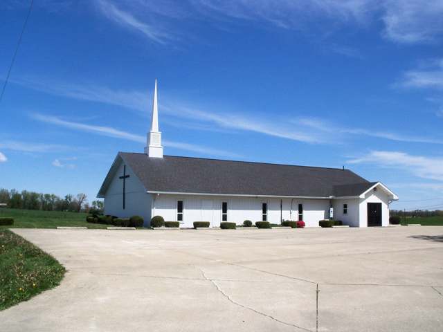
Photo: Roseohioresident, Wikimedia Commons, CC BY-SA 4.0 · Wikimedia Commons
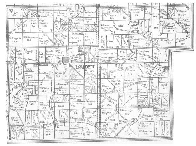
Photo: Linn Boyd Atkinson (1894 map); photographed by Roseohioresident, public domain · Wikimedia Commons
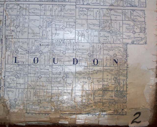
Photo: R.H. Lee, County Engineer (1915 atlas); photographed by Roseohioresident, public domain · Wikimedia Commons
Local history sources: ohiogenealogyexpress.com · en.wikipedia.org · en.wikipedia.org · en.wikipedia.org · en.wikipedia.org · commons.wikimedia.org · commons.wikimedia.org · commons.wikimedia.org · archive.org
Historic places
1 place in Loudon Township, Carroll County on the National Register of Historic Places. Press a pin or a name for its whole record.
-
Kilgore Union Presbyterian ChurchBuilding · Carrollton · listed 1995
- Address
- 7219 Germano Rd. SE
- Where
- Carrollton, Carroll County · ZIP 43903
- What it is
- Building
- Listed on the National Register
- 1995
- NRIS reference number
- 95000166
- Coordinates
- 40.46039, -80.99970
National Register file (NPS) ↗ Search Wikipedia ↗ Street map and directions ↗ On the Cracked Buckeye map
Source: National Park Service, National Register of Historic Places point file. The listing year is shown where NPS's certification date agrees with the listing's reference number. Listing recognizes significance; it does not restrict a private owner.
Water
Mostly private wells The water here
- HCWSD - Germano Water and Sewer38% of residentsGroundwater wells (1 wells)
- Carrollton Village38% of residentsGroundwater wells (10 wells)
- Scio18% of residentsGroundwater wells (2 wells)
- Jewett Village6% of residentsGroundwater wells (2 wells)
- Rockwood Park0% of residentsGroundwater wells (2 wells)
- Hopedale Village0% of residentsBlend: Ohio River (via Jefferson Co. WSD/Toronto) and Tappan Lake (via HCWSD East Cadiz)
Hospitals, fire stations and more
Inside Loudon Township, Carroll County's boundary: 2 fire and EMS stations, 85 shale and injection wells and 1 spill case. Press a pin or a name for its whole record and its source.
Fire and EMS stations (2)
-
Amsterdam Volunteer Fire CompanyAmsterdam
- Address
- 6223 Steubenville Road Southeast, Amsterdam, OH 43903
- Coordinates
- 40.47422, -80.92517
USGS National Map structures (source) ↗ Street map and directions ↗
-
Loudon Township Volunteer Fire DepartmentCarrollton
- Address
- 7177 Germano Road Southeast, Carrollton, OH 44615
- Coordinates
- 40.46136, -81.00124
USGS National Map structures (source) ↗ Street map and directions ↗
Source: USGS National Map structures (most Ohio records last updated 2019 to 2022), checked against the Columbus and Cleveland station lists. The department that answers a call is set by jurisdiction and mutual aid, not by distance.
Shale and injection wells (85)
-
Anderson 31-12-4 10HUtica shale well
- What it is
- Utica shale well
- Drilled sideways
- Yes
- Operator
- Eog Ohio, Llc
- County
- Carroll County
- API well number
- 34019222720000
- Coordinates
- 40.47349, -80.96949
ODNR oil and gas wells (source) ↗ Street map and directions ↗
The point is the surface well head (the pad); a horizontal well runs a mile or more underground from it.
-
Anderson 31-12-4 1HUtica shale well
- What it is
- Utica shale well
- Drilled sideways
- Yes
- Operator
- Eog Ohio, Llc
- County
- Carroll County
- API well number
- 34019222760000
- Coordinates
- 40.47346, -80.96958
ODNR oil and gas wells (source) ↗ Street map and directions ↗
The point is the surface well head (the pad); a horizontal well runs a mile or more underground from it.
-
Anderson 31-12-4 3HUtica shale well
- What it is
- Utica shale well
- Drilled sideways
- Yes
- Operator
- Eog Ohio, Llc
- County
- Carroll County
- API well number
- 34019222750000
- Coordinates
- 40.47352, -80.96958
ODNR oil and gas wells (source) ↗ Street map and directions ↗
The point is the surface well head (the pad); a horizontal well runs a mile or more underground from it.
-
Anderson 31-12-4 5HUtica shale well
- What it is
- Utica shale well
- Drilled sideways
- Yes
- Operator
- Eog Ohio, Llc
- County
- Carroll County
- API well number
- 34019222740000
- Coordinates
- 40.47355, -80.96949
ODNR oil and gas wells (source) ↗ Street map and directions ↗
The point is the surface well head (the pad); a horizontal well runs a mile or more underground from it.
-
Anderson 31-12-4 6HUtica shale well
- What it is
- Utica shale well
- Drilled sideways
- Yes
- Operator
- Eog Ohio, Llc
- County
- Carroll County
- API well number
- 34019222730000
- Coordinates
- 40.47341, -80.96958
ODNR oil and gas wells (source) ↗ Street map and directions ↗
The point is the surface well head (the pad); a horizontal well runs a mile or more underground from it.
-
Anderson 31-12-4 8HUtica shale well
- What it is
- Utica shale well
- Drilled sideways
- Yes
- Operator
- Eog Ohio, Llc
- County
- Carroll County
- API well number
- 34019222780000
- Coordinates
- 40.47344, -80.96949
ODNR oil and gas wells (source) ↗ Street map and directions ↗
The point is the surface well head (the pad); a horizontal well runs a mile or more underground from it.
-
Appalachian 16-12-5 10HUtica shale well
- What it is
- Utica shale well
- Drilled sideways
- Yes
- Operator
- Eog Ohio, Llc
- County
- Carroll County
- API well number
- 34019222640000
- Coordinates
- 40.44083, -81.02265
ODNR oil and gas wells (source) ↗ Street map and directions ↗
The point is the surface well head (the pad); a horizontal well runs a mile or more underground from it.
-
Appalachian 16-12-5 1HUtica shale well
- What it is
- Utica shale well
- Drilled sideways
- Yes
- Operator
- Eog Ohio, Llc
- County
- Carroll County
- API well number
- 34019222360000
- Coordinates
- 40.44090, -81.02282
ODNR oil and gas wells (source) ↗ Street map and directions ↗
The point is the surface well head (the pad); a horizontal well runs a mile or more underground from it.
-
Appalachian 16-12-5 3HUtica shale well
- What it is
- Utica shale well
- Drilled sideways
- Yes
- Operator
- Eog Ohio, Llc
- County
- Carroll County
- API well number
- 34019222410000
- Coordinates
- 40.44090, -81.02275
ODNR oil and gas wells (source) ↗ Street map and directions ↗
The point is the surface well head (the pad); a horizontal well runs a mile or more underground from it.
-
Appalachian 16-12-5 5HUtica shale well
- What it is
- Utica shale well
- Drilled sideways
- Yes
- Operator
- Eog Ohio, Llc
- County
- Carroll County
- API well number
- 34019222400000
- Coordinates
- 40.44090, -81.02268
ODNR oil and gas wells (source) ↗ Street map and directions ↗
The point is the surface well head (the pad); a horizontal well runs a mile or more underground from it.
-
Appalachian 16-12-5 6HUtica shale well
- What it is
- Utica shale well
- Drilled sideways
- Yes
- Operator
- Eog Ohio, Llc
- County
- Carroll County
- API well number
- 34019222660000
- Coordinates
- 40.44083, -81.02279
ODNR oil and gas wells (source) ↗ Street map and directions ↗
The point is the surface well head (the pad); a horizontal well runs a mile or more underground from it.
-
Appalachian 16-12-5 8HUtica shale well
- What it is
- Utica shale well
- Drilled sideways
- Yes
- Operator
- Eog Ohio, Llc
- County
- Carroll County
- API well number
- 34019222650000
- Coordinates
- 40.44083, -81.02272
ODNR oil and gas wells (source) ↗ Street map and directions ↗
The point is the surface well head (the pad); a horizontal well runs a mile or more underground from it.
-
Barbara 5-12-5 10HUtica shale well
- What it is
- Utica shale well
- Drilled sideways
- Yes
- Operator
- Eog Ohio, Llc
- County
- Carroll County
- API well number
- 34019223290000
- Coordinates
- 40.44182, -80.99396
ODNR oil and gas wells (source) ↗ Street map and directions ↗
The point is the surface well head (the pad); a horizontal well runs a mile or more underground from it.
-
Barbara 5-12-5 6HUtica shale well
- What it is
- Utica shale well
- Drilled sideways
- Yes
- Operator
- Eog Ohio, Llc
- County
- Carroll County
- API well number
- 34019223300000
- Coordinates
- 40.44177, -80.99393
ODNR oil and gas wells (source) ↗ Street map and directions ↗
The point is the surface well head (the pad); a horizontal well runs a mile or more underground from it.
-
Barbara 5-12-5 8HUtica shale well
- What it is
- Utica shale well
- Drilled sideways
- Yes
- Operator
- Eog Ohio, Llc
- County
- Carroll County
- API well number
- 34019223280000
- Coordinates
- 40.44182, -80.99396
ODNR oil and gas wells (source) ↗ Street map and directions ↗
The point is the surface well head (the pad); a horizontal well runs a mile or more underground from it.
-
Colescott 11-12-5 10HUtica shale well
- What it is
- Utica shale well
- Drilled sideways
- Yes
- Operator
- Eog Ohio, Llc
- County
- Carroll County
- API well number
- 34019221600000
- Coordinates
- 40.45032, -81.01536
ODNR oil and gas wells (source) ↗ Street map and directions ↗
The point is the surface well head (the pad); a horizontal well runs a mile or more underground from it.
-
Colescott 11-12-5 1HUtica shale well
- What it is
- Utica shale well
- Drilled sideways
- Yes
- Operator
- Eog Ohio, Llc
- County
- Carroll County
- API well number
- 34019222060000
- Coordinates
- 40.45032, -81.01544
ODNR oil and gas wells (source) ↗ Street map and directions ↗
The point is the surface well head (the pad); a horizontal well runs a mile or more underground from it.
-
Colescott 11-12-5 3HUtica shale well
- What it is
- Utica shale well
- Drilled sideways
- Yes
- Operator
- Eog Ohio, Llc
- County
- Carroll County
- API well number
- 34019221790000
- Coordinates
- 40.45037, -81.01541
ODNR oil and gas wells (source) ↗ Street map and directions ↗
The point is the surface well head (the pad); a horizontal well runs a mile or more underground from it.
-
Colescott 11-12-5 5HUtica shale well
- What it is
- Utica shale well
- Drilled sideways
- Yes
- Operator
- Eog Ohio, Llc
- County
- Carroll County
- API well number
- 34019221880000
- Coordinates
- 40.45037, -81.01533
ODNR oil and gas wells (source) ↗ Street map and directions ↗
The point is the surface well head (the pad); a horizontal well runs a mile or more underground from it.
-
Colescott 11-12-5 6HUtica shale well
- What it is
- Utica shale well
- Drilled sideways
- Yes
- Operator
- Eog Ohio, Llc
- County
- Carroll County
- API well number
- 34019222390000
- Coordinates
- 40.45027, -81.01547
ODNR oil and gas wells (source) ↗ Street map and directions ↗
The point is the surface well head (the pad); a horizontal well runs a mile or more underground from it.
-
Colescott 11-12-5 8HUtica shale well
- What it is
- Utica shale well
- Drilled sideways
- Yes
- Operator
- Eog Ohio, Llc
- County
- Carroll County
- API well number
- 34019222420000
- Coordinates
- 40.45027, -81.01539
ODNR oil and gas wells (source) ↗ Street map and directions ↗
The point is the surface well head (the pad); a horizontal well runs a mile or more underground from it.
-
Elwood 32-12-4 1HUtica shale well
- What it is
- Utica shale well
- Drilled sideways
- Yes
- Operator
- Eog Ohio, Llc
- County
- Carroll County
- API well number
- 34019221990000
- Coordinates
- 40.48525, -80.96331
ODNR oil and gas wells (source) ↗ Street map and directions ↗
The point is the surface well head (the pad); a horizontal well runs a mile or more underground from it.
-
Elwood 32-12-4 3HUtica shale well
- What it is
- Utica shale well
- Drilled sideways
- Yes
- Operator
- Eog Ohio, Llc
- County
- Carroll County
- API well number
- 34019221500000
- Coordinates
- 40.48531, -80.96330
ODNR oil and gas wells (source) ↗ Street map and directions ↗
The point is the surface well head (the pad); a horizontal well runs a mile or more underground from it.
-
Elwood 32-12-4 5HUtica shale well
- What it is
- Utica shale well
- Drilled sideways
- Yes
- Operator
- Eog Ohio, Llc
- County
- Carroll County
- API well number
- 34019222040000
- Coordinates
- 40.48528, -80.96323
ODNR oil and gas wells (source) ↗ Street map and directions ↗
The point is the surface well head (the pad); a horizontal well runs a mile or more underground from it.
-
Elwood South 32-12-4 10HUtica shale well
- What it is
- Utica shale well
- Drilled sideways
- Yes
- Operator
- Eog Ohio, Llc
- County
- Carroll County
- API well number
- 34019221820000
- Coordinates
- 40.48522, -80.96323
ODNR oil and gas wells (source) ↗ Street map and directions ↗
The point is the surface well head (the pad); a horizontal well runs a mile or more underground from it.
-
Elwood South 32-12-4 6HUtica shale well
- What it is
- Utica shale well
- Drilled sideways
- Yes
- Operator
- Eog Ohio, Llc
- County
- Carroll County
- API well number
- 34019222050000
- Coordinates
- 40.48520, -80.96330
ODNR oil and gas wells (source) ↗ Street map and directions ↗
The point is the surface well head (the pad); a horizontal well runs a mile or more underground from it.
-
Elwood South 32-12-4 8HUtica shale well
- What it is
- Utica shale well
- Drilled sideways
- Yes
- Operator
- Eog Ohio, Llc
- County
- Carroll County
- API well number
- 34019221810000
- Coordinates
- 40.48517, -80.96323
ODNR oil and gas wells (source) ↗ Street map and directions ↗
The point is the surface well head (the pad); a horizontal well runs a mile or more underground from it.
-
Henderson Family 34-11-4 10HUtica shale well
- What it is
- Utica shale well
- Drilled sideways
- Yes
- Operator
- Eog Ohio, Llc
- County
- Carroll County
- API well number
- 34019222160000
- Coordinates
- 40.43899, -80.97933
ODNR oil and gas wells (source) ↗ Street map and directions ↗
The point is the surface well head (the pad); a horizontal well runs a mile or more underground from it.
-
Henderson Family 34-11-4 1HUtica shale well
- What it is
- Utica shale well
- Drilled sideways
- Yes
- Operator
- Eog Ohio, Llc
- County
- Carroll County
- API well number
- 34019222100000
- Coordinates
- 40.43899, -80.97953
ODNR oil and gas wells (source) ↗ Street map and directions ↗
The point is the surface well head (the pad); a horizontal well runs a mile or more underground from it.
-
Henderson Family 34-11-4 3HUtica shale well
- What it is
- Utica shale well
- Drilled sideways
- Yes
- Operator
- Eog Ohio, Llc
- County
- Carroll County
- API well number
- 34019222090000
- Coordinates
- 40.43902, -80.97947
ODNR oil and gas wells (source) ↗ Street map and directions ↗
The point is the surface well head (the pad); a horizontal well runs a mile or more underground from it.
-
Henderson Family 34-11-4 5HUtica shale well
- What it is
- Utica shale well
- Drilled sideways
- Yes
- Operator
- Eog Ohio, Llc
- County
- Carroll County
- API well number
- 34019221890000
- Coordinates
- 40.43904, -80.97940
ODNR oil and gas wells (source) ↗ Street map and directions ↗
The point is the surface well head (the pad); a horizontal well runs a mile or more underground from it.
-
Henderson Family 34-11-4 6HUtica shale well
- What it is
- Utica shale well
- Drilled sideways
- Yes
- Operator
- Eog Ohio, Llc
- County
- Carroll County
- API well number
- 34019221870000
- Coordinates
- 40.43895, -80.97946
ODNR oil and gas wells (source) ↗ Street map and directions ↗
The point is the surface well head (the pad); a horizontal well runs a mile or more underground from it.
-
Henderson Family 34-11-4 8HUtica shale well
- What it is
- Utica shale well
- Drilled sideways
- Yes
- Operator
- Eog Ohio, Llc
- County
- Carroll County
- API well number
- 34019222080000
- Coordinates
- 40.43897, -80.97940
ODNR oil and gas wells (source) ↗ Street map and directions ↗
The point is the surface well head (the pad); a horizontal well runs a mile or more underground from it.
-
Jc Acres 12-12-5 10HUtica shale well
- What it is
- Utica shale well
- Drilled sideways
- Yes
- Operator
- Eog Ohio, Llc
- County
- Carroll County
- API well number
- 34019222550000
- Coordinates
- 40.46956, -81.00517
ODNR oil and gas wells (source) ↗ Street map and directions ↗
The point is the surface well head (the pad); a horizontal well runs a mile or more underground from it.
-
Jc Acres 12-12-5 1HUtica shale well
- What it is
- Utica shale well
- Drilled sideways
- Yes
- Operator
- Eog Ohio, Llc
- County
- Carroll County
- API well number
- 34019224280000
- Coordinates
- 40.46951, -81.00536
ODNR oil and gas wells (source) ↗ Street map and directions ↗
The point is the surface well head (the pad); a horizontal well runs a mile or more underground from it.
-
Jc Acres 12-12-5 3HUtica shale well
- What it is
- Utica shale well
- Drilled sideways
- Yes
- Operator
- Eog Ohio, Llc
- County
- Carroll County
- API well number
- 34019222570000
- Coordinates
- 40.46955, -81.00531
ODNR oil and gas wells (source) ↗ Street map and directions ↗
The point is the surface well head (the pad); a horizontal well runs a mile or more underground from it.
-
Jc Acres 12-12-5 5HUtica shale well
- What it is
- Utica shale well
- Drilled sideways
- Yes
- Operator
- Eog Ohio, Llc
- County
- Carroll County
- API well number
- 34019222560000
- Coordinates
- 40.46959, -81.00525
ODNR oil and gas wells (source) ↗ Street map and directions ↗
The point is the surface well head (the pad); a horizontal well runs a mile or more underground from it.
-
Jc Acres 12-12-5 6HUtica shale well
- What it is
- Utica shale well
- Drilled sideways
- Yes
- Operator
- Eog Ohio, Llc
- County
- Carroll County
- API well number
- 34019224450000
- Coordinates
- 40.46948, -81.00527
ODNR oil and gas wells (source) ↗ Street map and directions ↗
The point is the surface well head (the pad); a horizontal well runs a mile or more underground from it.
-
Jc Acres 12-12-5 8HUtica shale well
- What it is
- Utica shale well
- Drilled sideways
- Yes
- Operator
- Eog Ohio, Llc
- County
- Carroll County
- API well number
- 34019224460000
- Coordinates
- 40.46952, -81.00522
ODNR oil and gas wells (source) ↗ Street map and directions ↗
The point is the surface well head (the pad); a horizontal well runs a mile or more underground from it.
-
Kohler 1-13-5 10HUtica shale well
- What it is
- Utica shale well
- Drilled sideways
- Yes
- Operator
- Eog Ohio, Llc
- County
- Carroll County
- API well number
- 34019222220000
- Coordinates
- 40.47188, -80.99259
ODNR oil and gas wells (source) ↗ Street map and directions ↗
The point is the surface well head (the pad); a horizontal well runs a mile or more underground from it.
-
Kohler 1-13-5 1HUtica shale well
- What it is
- Utica shale well
- Drilled sideways
- Yes
- Operator
- Eog Ohio, Llc
- County
- Carroll County
- API well number
- 34019222180000
- Coordinates
- 40.47196, -80.99265
ODNR oil and gas wells (source) ↗ Street map and directions ↗
The point is the surface well head (the pad); a horizontal well runs a mile or more underground from it.
-
Kohler 1-13-5 5HUtica shale well
- What it is
- Utica shale well
- Drilled sideways
- Yes
- Operator
- Eog Ohio, Llc
- County
- Carroll County
- API well number
- 34019222170000
- Coordinates
- 40.47193, -80.99258
ODNR oil and gas wells (source) ↗ Street map and directions ↗
The point is the surface well head (the pad); a horizontal well runs a mile or more underground from it.
-
Kohler 1-13-5 6HUtica shale well
- What it is
- Utica shale well
- Drilled sideways
- Yes
- Operator
- Eog Ohio, Llc
- County
- Carroll County
- API well number
- 34019222190000
- Coordinates
- 40.47190, -80.99266
ODNR oil and gas wells (source) ↗ Street map and directions ↗
The point is the surface well head (the pad); a horizontal well runs a mile or more underground from it.
-
Kohler 1-13-5 8HUtica shale well
- What it is
- Utica shale well
- Drilled sideways
- Yes
- Operator
- Eog Ohio, Llc
- County
- Carroll County
- API well number
- 34019221730000
- Coordinates
- 40.47185, -80.99266
ODNR oil and gas wells (source) ↗ Street map and directions ↗
The point is the surface well head (the pad); a horizontal well runs a mile or more underground from it.
-
Lucas 35-11-4 10HUtica shale well
- What it is
- Utica shale well
- Drilled sideways
- Yes
- Operator
- Eog Ohio, Llc
- County
- Carroll County
- API well number
- 34019225490000
- Coordinates
- 40.44956, -80.96109
ODNR oil and gas wells (source) ↗ Street map and directions ↗
The point is the surface well head (the pad); a horizontal well runs a mile or more underground from it.
-
Lucas 35-11-4 1HUtica shale well
- What it is
- Utica shale well
- Drilled sideways
- Yes
- Operator
- Eog Ohio, Llc
- County
- Carroll County
- API well number
- 34019225420000
- Coordinates
- 40.44965, -80.96117
ODNR oil and gas wells (source) ↗ Street map and directions ↗
The point is the surface well head (the pad); a horizontal well runs a mile or more underground from it.
-
Lucas 35-11-4 3HUtica shale well
- What it is
- Utica shale well
- Drilled sideways
- Yes
- Operator
- Eog Ohio, Llc
- County
- Carroll County
- API well number
- 34019222230000
- Coordinates
- 40.44967, -80.96108
ODNR oil and gas wells (source) ↗ Street map and directions ↗
The point is the surface well head (the pad); a horizontal well runs a mile or more underground from it.
-
Lucas 35-11-4 5HUtica shale well
- What it is
- Utica shale well
- Drilled sideways
- Yes
- Operator
- Eog Ohio, Llc
- County
- Carroll County
- API well number
- 34019225410000
- Coordinates
- 40.44962, -80.96108
ODNR oil and gas wells (source) ↗ Street map and directions ↗
The point is the surface well head (the pad); a horizontal well runs a mile or more underground from it.
-
Lucas 35-11-4 6HUtica shale well
- What it is
- Utica shale well
- Drilled sideways
- Yes
- Operator
- Eog Ohio, Llc
- County
- Carroll County
- API well number
- 34019221620000
- Coordinates
- 40.44960, -80.96117
ODNR oil and gas wells (source) ↗ Street map and directions ↗
The point is the surface well head (the pad); a horizontal well runs a mile or more underground from it.
-
Lucas 35-11-4 8HUtica shale well
- What it is
- Utica shale well
- Drilled sideways
- Yes
- Operator
- Eog Ohio, Llc
- County
- Carroll County
- API well number
- 34019221800000
- Coordinates
- 40.44954, -80.96118
ODNR oil and gas wells (source) ↗ Street map and directions ↗
The point is the surface well head (the pad); a horizontal well runs a mile or more underground from it.
-
Palmer 1-13-5 10HUtica shale well
- What it is
- Utica shale well
- Drilled sideways
- Yes
- Operator
- Eog Ohio, Llc
- County
- Carroll County
- API well number
- 34019222500000
- Coordinates
- 40.47696, -80.98398
ODNR oil and gas wells (source) ↗ Street map and directions ↗
The point is the surface well head (the pad); a horizontal well runs a mile or more underground from it.
-
Palmer 1-13-5 1HUtica shale well
- What it is
- Utica shale well
- Drilled sideways
- Yes
- Operator
- Eog Ohio, Llc
- County
- Carroll County
- API well number
- 34019222680000
- Coordinates
- 40.47693, -80.98407
ODNR oil and gas wells (source) ↗ Street map and directions ↗
The point is the surface well head (the pad); a horizontal well runs a mile or more underground from it.
-
Palmer 1-13-5 3HUtica shale well
- What it is
- Utica shale well
- Drilled sideways
- Yes
- Operator
- Eog Ohio, Llc
- County
- Carroll County
- API well number
- 34019222700000
- Coordinates
- 40.47696, -80.98412
ODNR oil and gas wells (source) ↗ Street map and directions ↗
The point is the surface well head (the pad); a horizontal well runs a mile or more underground from it.
-
Palmer 1-13-5 5HUtica shale well
- What it is
- Utica shale well
- Drilled sideways
- Yes
- Operator
- Eog Ohio, Llc
- County
- Carroll County
- API well number
- 34019222690000
- Coordinates
- 40.47700, -80.98404
ODNR oil and gas wells (source) ↗ Street map and directions ↗
The point is the surface well head (the pad); a horizontal well runs a mile or more underground from it.
-
Palmer 1-13-5 6HUtica shale well
- What it is
- Utica shale well
- Drilled sideways
- Yes
- Operator
- Eog Ohio, Llc
- County
- Carroll County
- API well number
- 34019222670000
- Coordinates
- 40.47706, -80.98401
ODNR oil and gas wells (source) ↗ Street map and directions ↗
The point is the surface well head (the pad); a horizontal well runs a mile or more underground from it.
-
Palmer 1-13-5 8HUtica shale well
- What it is
- Utica shale well
- Drilled sideways
- Yes
- Operator
- Eog Ohio, Llc
- County
- Carroll County
- API well number
- 34019222370000
- Coordinates
- 40.47692, -80.98393
ODNR oil and gas wells (source) ↗ Street map and directions ↗
The point is the surface well head (the pad); a horizontal well runs a mile or more underground from it.
-
Slates 16-12-5 10HUtica shale well
- What it is
- Utica shale well
- Drilled sideways
- Yes
- Operator
- Eog Ohio, Llc
- County
- Carroll County
- API well number
- 34019221830000
- Coordinates
- 40.44074, -81.03727
ODNR oil and gas wells (source) ↗ Street map and directions ↗
The point is the surface well head (the pad); a horizontal well runs a mile or more underground from it.
-
Slates 16-12-5 1HUtica shale well
- What it is
- Utica shale well
- Drilled sideways
- Yes
- Operator
- Eog Ohio, Llc
- County
- Carroll County
- API well number
- 34019221850000
- Coordinates
- 40.44079, -81.03745
ODNR oil and gas wells (source) ↗ Street map and directions ↗
The point is the surface well head (the pad); a horizontal well runs a mile or more underground from it.
-
Slates 16-12-5 3HUtica shale well
- What it is
- Utica shale well
- Drilled sideways
- Yes
- Operator
- Eog Ohio, Llc
- County
- Carroll County
- API well number
- 34019221420000
- Coordinates
- 40.44079, -81.03738
ODNR oil and gas wells (source) ↗ Street map and directions ↗
The point is the surface well head (the pad); a horizontal well runs a mile or more underground from it.
-
Slates 16-12-5 5HUtica shale well
- What it is
- Utica shale well
- Drilled sideways
- Yes
- Operator
- Eog Ohio, Llc
- County
- Carroll County
- API well number
- 34019222150000
- Coordinates
- 40.44079, -81.03731
ODNR oil and gas wells (source) ↗ Street map and directions ↗
The point is the surface well head (the pad); a horizontal well runs a mile or more underground from it.
-
Slates 16-12-5 6HUtica shale well
- What it is
- Utica shale well
- Drilled sideways
- Yes
- Operator
- Eog Ohio, Llc
- County
- Carroll County
- API well number
- 34019221840000
- Coordinates
- 40.44074, -81.03741
ODNR oil and gas wells (source) ↗ Street map and directions ↗
The point is the surface well head (the pad); a horizontal well runs a mile or more underground from it.
-
Slates 16-12-5 8HUtica shale well
- What it is
- Utica shale well
- Drilled sideways
- Yes
- Operator
- Eog Ohio, Llc
- County
- Carroll County
- API well number
- 34019221750000
- Coordinates
- 40.44074, -81.03734
ODNR oil and gas wells (source) ↗ Street map and directions ↗
The point is the surface well head (the pad); a horizontal well runs a mile or more underground from it.
-
Stropki 20-12-4 1HUtica shale well
- What it is
- Utica shale well
- Drilled sideways
- Yes
- Operator
- Eog Ohio, Llc
- County
- Carroll County
- API well number
- 34019223890000
- Coordinates
- 40.48828, -80.94020
ODNR oil and gas wells (source) ↗ Street map and directions ↗
The point is the surface well head (the pad); a horizontal well runs a mile or more underground from it.
-
Sunnybrook 25-12-4 6HUtica shale well
- What it is
- Utica shale well
- Drilled sideways
- Yes
- Operator
- Eog Ohio, Llc
- County
- Carroll County
- API well number
- 34019223210000
- Coordinates
- 40.47070, -80.94996
ODNR oil and gas wells (source) ↗ Street map and directions ↗
The point is the surface well head (the pad); a horizontal well runs a mile or more underground from it.
-
Tuckosh 35-11-4 10HUtica shale well
- What it is
- Utica shale well
- Drilled sideways
- Yes
- Operator
- Eog Ohio, Llc
- County
- Carroll County
- API well number
- 34019221480000
- Coordinates
- 40.44147, -80.96942
ODNR oil and gas wells (source) ↗ Street map and directions ↗
The point is the surface well head (the pad); a horizontal well runs a mile or more underground from it.
-
Tuckosh 35-11-4 1HUtica shale well
- What it is
- Utica shale well
- Drilled sideways
- Yes
- Operator
- Eog Ohio, Llc
- County
- Carroll County
- API well number
- 34019221380100
- Coordinates
- 40.44145, -80.96955
ODNR oil and gas wells (source) ↗ Street map and directions ↗
The point is the surface well head (the pad); a horizontal well runs a mile or more underground from it.
-
Tuckosh 35-11-4 3HUtica shale well
- What it is
- Utica shale well
- Drilled sideways
- Yes
- Operator
- Eog Ohio, Llc
- County
- Carroll County
- API well number
- 34019221340000
- Coordinates
- 40.44149, -80.96951
ODNR oil and gas wells (source) ↗ Street map and directions ↗
The point is the surface well head (the pad); a horizontal well runs a mile or more underground from it.
-
Tuckosh 35-11-4 5HUtica shale well
- What it is
- Utica shale well
- Drilled sideways
- Yes
- Operator
- Eog Ohio, Llc
- County
- Carroll County
- API well number
- 34019225550000
- Coordinates
- 40.44153, -80.96946
ODNR oil and gas wells (source) ↗ Street map and directions ↗
The point is the surface well head (the pad); a horizontal well runs a mile or more underground from it.
-
Tuckosh 35-11-4 6HUtica shale well
- What it is
- Utica shale well
- Drilled sideways
- Yes
- Operator
- Eog Ohio, Llc
- County
- Carroll County
- API well number
- 34019225560000
- Coordinates
- 40.44139, -80.96952
ODNR oil and gas wells (source) ↗ Street map and directions ↗
The point is the surface well head (the pad); a horizontal well runs a mile or more underground from it.
-
Tuckosh 35-11-4 8HUtica shale well
- What it is
- Utica shale well
- Drilled sideways
- Yes
- Operator
- Eog Ohio, Llc
- County
- Carroll County
- API well number
- 34019225570000
- Coordinates
- 40.44143, -80.96948
ODNR oil and gas wells (source) ↗ Street map and directions ↗
The point is the surface well head (the pad); a horizontal well runs a mile or more underground from it.
-
Walker 12-12-5 10HUtica shale well
- What it is
- Utica shale well
- Drilled sideways
- Yes
- Operator
- Eog Ohio, Llc
- County
- Carroll County
- API well number
- 34019221590000
- Coordinates
- 40.45949, -81.00882
ODNR oil and gas wells (source) ↗ Street map and directions ↗
The point is the surface well head (the pad); a horizontal well runs a mile or more underground from it.
-
Walker 12-12-5 1HUtica shale well
- What it is
- Utica shale well
- Drilled sideways
- Yes
- Operator
- Eog Ohio, Llc
- County
- Carroll County
- API well number
- 34019222610000
- Coordinates
- 40.45949, -81.00896
ODNR oil and gas wells (source) ↗ Street map and directions ↗
The point is the surface well head (the pad); a horizontal well runs a mile or more underground from it.
-
Walker 12-12-5 3HUtica shale well
- What it is
- Utica shale well
- Drilled sideways
- Yes
- Operator
- Eog Ohio, Llc
- County
- Carroll County
- API well number
- 34019222620000
- Coordinates
- 40.45956, -81.00892
ODNR oil and gas wells (source) ↗ Street map and directions ↗
The point is the surface well head (the pad); a horizontal well runs a mile or more underground from it.
-
Walker 12-12-5 5HUtica shale well
- What it is
- Utica shale well
- Drilled sideways
- Yes
- Operator
- Eog Ohio, Llc
- County
- Carroll County
- API well number
- 34019222630000
- Coordinates
- 40.45952, -81.00887
ODNR oil and gas wells (source) ↗ Street map and directions ↗
The point is the surface well head (the pad); a horizontal well runs a mile or more underground from it.
-
Walker 12-12-5 6HUtica shale well
- What it is
- Utica shale well
- Drilled sideways
- Yes
- Operator
- Eog Ohio, Llc
- County
- Carroll County
- API well number
- 34019221570000
- Coordinates
- 40.45946, -81.00891
ODNR oil and gas wells (source) ↗ Street map and directions ↗
The point is the surface well head (the pad); a horizontal well runs a mile or more underground from it.
-
Walker 12-12-5 8HUtica shale well
- What it is
- Utica shale well
- Drilled sideways
- Yes
- Operator
- Eog Ohio, Llc
- County
- Carroll County
- API well number
- 34019221580000
- Coordinates
- 40.45942, -81.00886
ODNR oil and gas wells (source) ↗ Street map and directions ↗
The point is the surface well head (the pad); a horizontal well runs a mile or more underground from it.
-
Woodland 26-12-4 10HUtica shale well
- What it is
- Utica shale well
- Drilled sideways
- Yes
- Operator
- Eog Ohio, Llc
- County
- Carroll County
- API well number
- 34019226110000
- Coordinates
- 40.48810, -80.95082
ODNR oil and gas wells (source) ↗ Street map and directions ↗
The point is the surface well head (the pad); a horizontal well runs a mile or more underground from it.
-
Woodland 26-12-4 1HUtica shale well
- What it is
- Utica shale well
- Drilled sideways
- Yes
- Operator
- Eog Ohio, Llc
- County
- Carroll County
- API well number
- 34019226140000
- Coordinates
- 40.48795, -80.95075
ODNR oil and gas wells (source) ↗ Street map and directions ↗
The point is the surface well head (the pad); a horizontal well runs a mile or more underground from it.
-
Woodland 26-12-4 2HUtica shale well
- What it is
- Utica shale well
- Drilled sideways
- Yes
- Operator
- Eog Ohio, Llc
- County
- Carroll County
- API well number
- 34019226130000
- Coordinates
- 40.48801, -80.95074
ODNR oil and gas wells (source) ↗ Street map and directions ↗
The point is the surface well head (the pad); a horizontal well runs a mile or more underground from it.
-
Woodland 26-12-4 3HUtica shale well
- What it is
- Utica shale well
- Drilled sideways
- Yes
- Operator
- Eog Ohio, Llc
- County
- Carroll County
- API well number
- 34019224470000
- Coordinates
- 40.48804, -80.95082
ODNR oil and gas wells (source) ↗ Street map and directions ↗
The point is the surface well head (the pad); a horizontal well runs a mile or more underground from it.
-
Woodland 26-12-4 4HUtica shale well
- What it is
- Utica shale well
- Drilled sideways
- Yes
- Operator
- Eog Ohio, Llc
- County
- Carroll County
- API well number
- 34019226150000
- Coordinates
- 40.48806, -80.95073
ODNR oil and gas wells (source) ↗ Street map and directions ↗
The point is the surface well head (the pad); a horizontal well runs a mile or more underground from it.
-
Woodland 26-12-4 5HUtica shale well
- What it is
- Utica shale well
- Drilled sideways
- Yes
- Operator
- Eog Ohio, Llc
- County
- Carroll County
- API well number
- 34019226120000
- Coordinates
- 40.48812, -80.95072
ODNR oil and gas wells (source) ↗ Street map and directions ↗
The point is the surface well head (the pad); a horizontal well runs a mile or more underground from it.
-
Woodland 26-12-4 6HUtica shale well
- What it is
- Utica shale well
- Drilled sideways
- Yes
- Operator
- Eog Ohio, Llc
- County
- Carroll County
- API well number
- 34019224180000
- Coordinates
- 40.48815, -80.95081
ODNR oil and gas wells (source) ↗ Street map and directions ↗
The point is the surface well head (the pad); a horizontal well runs a mile or more underground from it.
-
Woodland 26-12-4 7HUtica shale well
- What it is
- Utica shale well
- Drilled sideways
- Yes
- Operator
- Eog Ohio, Llc
- County
- Carroll County
- API well number
- 34019226090000
- Coordinates
- 40.48793, -80.95084
ODNR oil and gas wells (source) ↗ Street map and directions ↗
The point is the surface well head (the pad); a horizontal well runs a mile or more underground from it.
-
Woodland 26-12-4 8HUtica shale well
- What it is
- Utica shale well
- Drilled sideways
- Yes
- Operator
- Eog Ohio, Llc
- County
- Carroll County
- API well number
- 34019226100000
- Coordinates
- 40.48799, -80.95083
ODNR oil and gas wells (source) ↗ Street map and directions ↗
The point is the surface well head (the pad); a horizontal well runs a mile or more underground from it.
Source: ODNR Division of Oil and Gas Resources well inventory (September 2026): drilled Utica, Marcellus and horizontal wells and Class II injection wells not plugged. Older vertical wells are on the full map.
Spills reported since 2021 (1)
-
Oil Crude2022-11-20 · Brown Twp
- Reported
- 2022-11-20
- What spilled
- Oil Crude
- Where
- Brown Twp, Carroll County
- Ohio EPA district office
- NEDO
- Ohio EPA case number
- 2211EPA0001726
Ohio EPA spill reports (source) ↗ Street map and directions ↗
Source: Ohio EPA emergency response spill reports, 2021 to September 2026, one point per case where Ohio EPA placed it. A report is what the caller or responder recorded; amounts are often blank or estimated.
Its ZIP codes
Each ZIP code that touches Loudon Township, Carroll County, with the share of its residents who live here and the same headline figures as the ZIP page.
| ZIP | Share | Water | Radon | Home value | Schools | Flood |
|---|---|---|---|---|---|---|
| 43903 Loudon Township and Amsterdam | 33% | Mostly private wells | 9.9 pCi/L average radon | Median year built 1956 | Edison Local · 4 stars overall | 5.8% of residents in the 1% floodplain |
| 43988 North Township and Scio | 4% | Mostly private wells | 8.4 pCi/L average radon | Median year built 1963 | Harrison Hills City · 3 stars overall | 4.3% of residents in the 1% floodplain |
| 43986 Rumley Township and Jewett | 2% | Mostly private wells | 14.2 pCi/L average radon | Median year built 1962 | Harrison Hills City · 3 stars overall | 11% of residents in the 1% floodplain |
| 44615 Carrollton | 2% | Mostly private wells | 7.9 pCi/L average radon | Median year built 1969 | Carrollton Exempted Village · 4 stars overall | 1.3% of residents in the 1% floodplain |
On the November 3, 2026 ballot
Statewide question: State Issue 3: Voter ID
Local questions for Loudon Township, Carroll County, Jefferson County and its school district:
- Edison Local School District: Renews a 1.85-mill property tax levy for the current expenses of Edison Local School District for 5 years, beginning in 2027.
- Jefferson County: Renews a 1.5-mill property tax levy for the provide funds for operation of county 9-1-1 system of Jefferson County for 5 years, beginning in 2027.
Races, candidates and every question for an address: your ballot. County offices and judges are on your county board's sample ballot.
The county
Jefferson County: 21 ZIP codes, 33 cities, villages and townships with pages here, 63,597 people (Census Bureau estimate, July 2025).
Nearby places
Quick answers
What county is Loudon Township, Ohio in?
Loudon Township, Carroll County is a township in Jefferson County, Ohio, with 925 residents.
When was Loudon Township, Ohio founded?
Loudon Township, Carroll County was settled c. 1802; incorporated March 1836. Founders on record: Carroll County commissioners, organizing land out of the former Rock and Jefferson townships. Source
How did Loudon Township, Ohio get its name?
The township was named Loudon (an anglicized spelling of Loudoun) because most of its first settlers had emigrated from Loudoun County, Virginia, and wished to carry the name west with them. Source
What ZIP code is Loudon Township, Ohio?
Loudon Township, Carroll County is served by ZIP codes 43903 and 43988; 43903 holds the largest share of its residents.
Where does Loudon Township, Ohio get its water?
The main water source for Loudon Township, Carroll County (HCWSD - Germano Water and Sewer): Mostly private wells.
Cite this page
Cite this page as:
Cracked Buckeye, "Loudon Township, Carroll County", https://crackedbuckeye.com/place/loudon-township-carroll-county/, built 2026-11-02, accessed [date].
How to cite · Report a correction · Built 2026-11-02