How Bloom Township, Fairfield County began
Bloom Township was laid off in 1805 in the western tier of Fairfield County, taking in the sandstone-quarry town of Lithopolis, the small hamlets of Greencastle and Jefferson, and, at its extreme northern tip, a share of the canal-era hamlet of Lockville. Pennsylvania and German settlers named Courtright, Hoshor, Alspaugh and Hoy cleared farms along the infant Hocking River, which rises near the township's center, and around 1799 built Rock Mill into the rock ledges above the stream, a building still standing more than two centuries later beside a 1901 covered bridge. The township holds more documented mound-builder sites than most of its neighbors: two National Register Adena mounds, the Old Maid's Orchard Mound and the Coon Hunters Mound, plus a third mound near Greencastle opened by a Cincinnati scientist in 1880. Bloom remains one of Fairfield County's more rural townships even as Columbus-area growth reaches its northern edge near Canal Winchester.
Settled by 1801 (Abraham Van Courtright, a Pennsylvanian, among the first arrivals), incorporated 1805 (organized as a township).
Where the name comes from
No source consulted gives a specific reason for the name Bloom. The township's own chapter in the 1883 and 1912 county histories opens directly with its 1805 organization and list of early settlers, unlike the neighboring Violet Township chapter, which explains that name from local wildflowers. Ohio has Bloom Townships in several other counties (Ashland, Morrow, Richland, Seneca, Wood), which suggests a generic, aspirational choice of name rather than a locally specific story, but that is inference rather than a sourced fact.
Before the town
Bloom Township holds more documented mound-builder sites than most Fairfield County townships. In its northern end, inside what is now Chestnut Ridge Metro Park near Lithopolis, stands the Old Maid's Orchard Mound, an eight-foot-high, one-acre Adena burial mound listed on the National Register of Historic Places on July 15, 1974. Near Carroll, on the grounds of the Central Ohio Coonhunters Association, is the Coon Hunters Mound, a similar Adena mound five and a half feet high and sixty-five feet across at its base, listed on the National Register on May 2, 1974; like its neighbor, it has never been excavated. A third mound, near Greencastle, was opened a few years before the death of Cincinnati geologist Professor E. B. Andrews in 1880; he found a large quantity of human bone, chiefly skull and jaw fragments, concentrated at the mound's base and center, which the county historian took as evidence the remains belonged to the mound builders themselves rather than to a later Native burial, reasoning that Native custom buried the dead near the surface rather than at a mound's core. No source consulted names a specific Wyandot or Delaware village or camp within Bloom Township itself, though the entire area was ceded at the 1795 Treaty of Greenville and lay within the hunting range of the Wyandot town of Tarhetown at Lancaster, whose hunting parties are recorded visiting the Rock Mill settlement in the township's southeast into the early 1800s, drawn in part by the whiskey made there.
Nations recorded here: Adena culture, Wyandot.
- Old Maid's Orchard Mound (mound) — Chestnut Ridge Metro Park, northern Bloom Township, near Lithopolis, Adena culture, listed NRHP 1974 (en.wikipedia.org)
- Coon Hunters Mound (mound) — 6995 Coonpath Rd., grounds of the Central Ohio Coonhunters Association, near Carroll, Bloom Township, Adena culture, c. 500 BC - AD 400, listed NRHP 1974 (en.wikipedia.org)
- Greencastle mound (mound) — near Greencastle, Bloom Township, pre-contact, culture undetermined; excavated c. 1880 (archive.org)
Timeline
- — The Treaty of Greenville cedes most of Ohio, including the future Bloom Township, to the United States.
- — Abraham Van Courtright, a Pennsylvanian, settles near the later Betzer Church two miles south of Lockville, among the township's first settlers.
- — Rock Mill is built into the rock ledges above the Hocking River, the first mill of its kind in the township; grists were taken in at a gable window and let down to the hopper by rope.
- — Bloom Township is laid off and organized, in the western tier of Fairfield County.
- — Jesse D. Courtright lays out the village of Greencastle, surveyed by John Hamilton.
- — George Hoshor lays out the village of Jefferson, on the military road from Wheeling, Virginia, to the lakes.
- — The canal hamlet of Lockville is platted at the opening of the Ohio and Erie Canal, lying partly in Bloom and partly in Violet Township.
- — Professor E. B. Andrews of Lancaster excavates a mound near Greencastle, finding a large quantity of human bone at its base and center.
- — Jacob R. Brandt builds the Rock Mill Covered Bridge, a Queen Post truss span over the Hocking River gorge at Rock Mill.
- — The Coon Hunters Mound (May 2) and the Old Maid's Orchard Mound (July 15) are listed on the National Register of Historic Places.
- — Rock Mill itself is listed on the National Register of Historic Places.
- — The census records Bloom Township's population at 10,159.
Stories
Cut Into the Rock
When the first settlers along the young Hocking River needed to grind their corn, they did not build a mill so much as wedge one into the landscape. Rock Mill, raised about 1799, sat low down among the sandstone ledges above the river, so low that there was no room for a proper loading door: grists went in through a gable window and were let down to the hopper on ropes. It was the first mill of its kind in Bloom Township, and it outlasted the pioneers who built it by two centuries. In 1901 the carpenter Jacob R. Brandt added a companion structure a short distance off, a Queen Post truss covered bridge spanning the same gorge the mill had exploited, and both mill and bridge still stand, the bridge listed on the National Register since 1976 and the mill itself since 1990.
Two Mounds Left Alone
Not every mound in Bloom Township met the same fate. Sometime before his death in 1880, the Cincinnati geologist Professor E. B. Andrews dug a mound near Greencastle down to its base, turning up nearly half a bushel of human teeth, jawbones and skull fragments that he judged too old and too centrally placed to be a later Native burial. Two other Adena mounds in the township were left alone. The Old Maid's Orchard Mound, standing eight feet high on an acre of ground in what is now Chestnut Ridge Metro Park, and the Coon Hunters Mound, five and a half feet high on the grounds of a modern hunting club near Carroll, were both entered on the National Register of Historic Places within ten weeks of each other in 1974, and neither has ever been opened. Whatever the builders left inside is, more than two thousand years on, still there.
Photographs
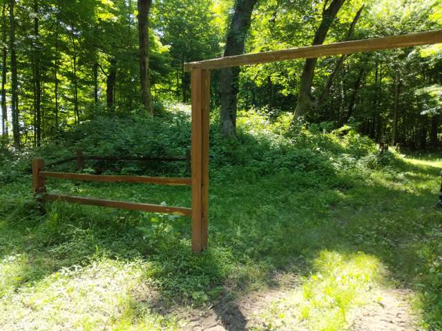
Photo: Beholder29, via Wikimedia Commons, CC BY-SA 4.0 · Wikimedia Commons
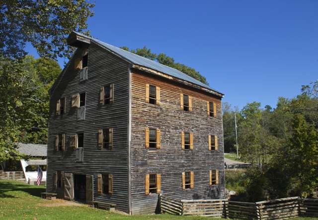
Photo: Sdenisky, via Wikimedia Commons, CC BY-SA 4.0 · Wikimedia Commons
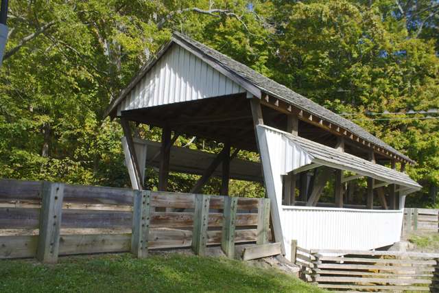
Photo: Sdenisky, via Wikimedia Commons, CC BY-SA 4.0 · Wikimedia Commons
Local history sources: archive.org · archive.org · en.wikipedia.org · en.wikipedia.org · en.wikipedia.org · en.wikipedia.org · en.wikipedia.org · en.wikipedia.org · commons.wikimedia.org · commons.wikimedia.org · commons.wikimedia.org
Water
Mostly private wells The water here
- Columbus Public Water System46% of residentsScioto River (Griggs & O'Shaughnessy), Hoover Reservoir on Big Walnut Ck, plus wells
- Lancaster City27% of residentsHocking River Valley Aquifer (wells)
- Canal Winchester City13% of residentsLocal groundwater wells (Franklin Co.)
- Carroll Village5% of residentsGroundwater wells (2 wells)
- Fairfield County Utilities3% of residentsLocal groundwater wells (central Ohio, aquifer undocumented)
- Lithopolis Village3% of residentsGroundwater wells (3 wells)
- Greenfield Twp Water District1% of residentsGroundwater wells (2 wells)
- Little Walnut Water Treatment Facility1% of residentsGroundwater wells (2 wells)
- Amanda Village0% of residentsGroundwater wells (3 wells)
- Pickerington City0% of residentslocal buried-valley aquifer (wells near Diley Road)
- Sugar Grove Village0% of residentsGroundwater wells (2 wells)
- Brookdale Mobile Home Park0% of residentsGroundwater wells (2 wells)
- Colony Village MHP0% of residentsGroundwater wells (1 wells)
Its ZIP codes
Each ZIP code that touches Bloom Township, Fairfield County, with the share of its residents who live here and the same headline figures as the ZIP page.
The county
Fairfield County: 13 ZIP codes, 27 cities, villages and townships, 144,692 people.
Nearby places
Cite this page
Cite this page as:
Cracked Buckeye (Open Shower Co), "Bloom Township, Fairfield County", https://crackedbuckeye.com/place/bloom-township-fairfield-county/, built 2026-09-16, accessed [date].
Machine-readable: /api/place/bloom-township-fairfield-county.json (open JSON, CC BY 4.0 for the compilation; the underlying records keep their own terms) · How to cite · Report a correction · Built 2026-09-16