How Lancaster began
Lancaster, the Fairfield County seat and now the county's largest city at about 40,000 people, grew up where Zane's Trace crossed the Hocking River on ground the Wyandot called the Standing Stone, after their village of Tarhe Town (Cranetown) on the river's north bank. Captain Joseph Hunter built the first cabin near the crossing in 1798; Ebenezer Zane, granted the section of land there for blazing the Trace, platted the town in 1800 and it was named New Lancaster for the Pennsylvania hometown of many of its first settlers, shortened to Lancaster in 1805. It became the seat of Fairfield County at the county's creation on December 9, 1800, grew on canal trade in the 1830s, and gave the country the Sherman brothers -- General William Tecumseh Sherman and Senator John Sherman -- both born in the same house on East Main Street. The Hocking Glass Company, founded in 1905 and merged into Anchor Hocking in 1937, made Lancaster a company town for glassware through the twentieth century.
Settled 1798 (Captain Joseph Hunter builds a cabin at 'Hunter's Settlement' on Zane's Trace, on the prairie just west of the Hocking River crossing, in April 1798), platted 1800 (Ebenezer Zane lays out and sells the first lots that fall; the plat was substantially complete by spring 1801), incorporated 1831 as an incorporated village; became a city of the third class in 1851, by Ebenezer Zane, proprietor of the section of land at the Hocking crossing.
Where the name comes from
The town was first called New Lancaster, in compliment to the many early settlers, including the influential Emanuel Carpenter family, who had emigrated from Lancaster, Pennsylvania. The Ohio legislature dropped the 'New' in 1805 to avoid confusion with the Pennsylvania town in the postal service, though the older name kept informal use for another twenty years.
Before the town
General George Sanderson's recollections, recorded in Hervey Scott's 1877 county history, describe a Wyandot town of about 500 people and 100 wigwams standing on the prairie along the Hocking River about where Lancaster's Broad Street and the later canal basin lay, extending back to the hill south of the site of the Methodist church. It was called Tarhe, or in English Cranetown, for its principal chief, Tarhe (the Crane), whose own wigwam stood near a spring that still fed the Hocking Canal's fourth lock. The bluff a mile north of the town site, later called Mount Pleasant, was known to the Wyandot as the Standing Stone, a landmark visible for miles up and down the valley; the 1912 county history records that the mountain went by 'the Indian name, Standing Stone' before it became Rising Park. A second Wyandot town, called Toby Town after its chief, stood about nine miles west near present Royalton and was inhabited by Wyandot and Lenape (Delaware) people together. The Wyandot ceded their claim to the Hocking valley at the Treaty of Greenville, signed August 3, 1795, and most withdrew toward the Sandusky River soon after, though Scott's history says a few lingered near their old hunting grounds and burial places for several years before finally leaving. Fairfield County's 1883 history separately describes about twenty Adena- or Hopewell-era mounds, circles and squares scattered through the county's townships (none within Lancaster itself), and records that Dr. M. Z. Kreider of Lancaster opened a mound about a mile southwest of the city, on the former Creed farm, finding a few bones and trinkets the historian guessed belonged to 'some Wyandot warrior' rather than the older mound-building culture.
Nations recorded here: Wyandot, Lenape (Delaware).
- Tarhe Town (Cranetown) (village) — north bank of the Hocking River, at the site of Lancaster, near the later canal basin and fourth lock, occupied at least by 1790; ceded and largely abandoned after the 1795 Treaty of Greenville (archive.org)
- Standing Stone (Mount Pleasant) (other) — a 250-foot sandstone bluff about one mile north of Main and Broad streets, Lancaster, used and named by the Wyandot before white settlement; became the city park Rising Park in the 19th century (archive.org)
- Toby Town (village) — about nine miles west of Tarhe Town, near present Royalton, within Fairfield County, before 1798, when the first white settlers reached the area (archive.org)
- Mound on the Creed farm (mound) — about one mile southwest of the city of Lancaster, prehistoric mound, opened in the 19th century by Dr. M. Z. Kreider of Lancaster; finds attributed by the historian to a Wyandot burial (archive.org)
Timeline
- — The Wyandot town of Tarhe (Cranetown), governed by Chief Tarhe and numbering about 500 people, stands on the north bank of the Hocking River at the site of the future Lancaster.
- — The Treaty of Greenville, signed August 3 between the United States and a coalition including the Wyandot, cedes most of the Hocking valley; the Wyandot soon withdraw toward the Sandusky River.
- — Ebenezer Zane's road, Zane's Trace, is cut from Wheeling to Limestone, Kentucky, crossing the Hocking River at the future site of Lancaster; Congress grants Zane the right to purchase land at the crossing.
- — Captain Joseph Hunter emigrates from Kentucky and builds a cabin on Zane's Trace just west of the Hocking crossing in April, the first white settlement in the upper Hocking Valley.
- — Samuel Coates Sr. and Jr. build a cabin at 'the Crossing of Hocking' in April; when a weekly mail route opens along Zane's Trace later that year, Coates becomes the first postmaster at the new settlement.
- — In the fall, Ebenezer Zane lays out and sells the first town lots, giving some free to mechanics who would build cabins and set up shop; the settlement is named New Lancaster for the many settlers from Lancaster, Pennsylvania.
- — On December 9, the governor and council of the Northwest Territory organize Fairfield County and name New Lancaster its seat of justice.
- — The Ohio legislature shortens the town's name from New Lancaster to Lancaster to avoid confusion with Lancaster, Pennsylvania, in the postal service.
- — The frame house at what is now 137 East Main Street is built; it will become the birthplace of both Sherman brothers.
- — Thomas Ewing, later a U.S. Senator and the first Secretary of the Interior, establishes his law practice in Lancaster, where he will live the rest of his life; the Sherman house is enlarged the same year.
- — William Tecumseh Sherman is born in the family house on East Main Street on February 8.
- — John Sherman, the future U.S. Senator and Treasury Secretary, is born in the same house on May 10, the eighth of Charles and Mary Sherman's eleven children.
- — Charles Sherman, a justice of the Ohio Supreme Court, dies suddenly of typhoid fever, leaving his widow with eleven children; nine-year-old William Tecumseh Sherman is taken in by neighbor Thomas Ewing.
- — Lancaster is incorporated as a village by act of the state legislature.
- — The Lancaster Lateral Canal Company is organized and its 'Side Cut' to the Ohio Canal at Carroll is put under contract.
- — The first canal boats are towed into Lancaster on the Side Cut on the Fourth of July -- the source itself is unsure which year -- celebrated by an estimated 10,000 people with a roasted ox at Cold Spring Hill.
- — The state Board of Public Works builds the Hocking Canal south from Lancaster in stages, reaching Nelsonville by 1840 and Athens by 1841, with 31 locks and 8 dams in all.
- — The Fairfield County Agricultural Society organizes, with John Reber as president; it holds the first Fairfield County Fair in Lancaster in October 1851.
- — Lancaster becomes a city of the third class.
- — The Ohio legislature funds a reform farm for boys near Lancaster; ten boys are brought from the Cincinnati House of Refuge and placed there on January 30, 1858.
- — Thomas Ewing dies in Lancaster on October 26 at age 81; his son-in-law's fame as General Sherman is by then secure.
- — The city erects its first waterworks, a pumping station on West Chestnut Street near the Hocking Canal with a standpipe for fire protection, drawing water from the canal.
- — The canal-fed fire system is abandoned for a new pump house on West Wheeling Street, drawing on an enlarged spring and infiltration gallery that begins supplying domestic as well as fire service.
- — A 2.5-million-gallon masonry reservoir is built on Walter's Hill northeast of the pump house to serve the growing water system.
- — The city drills municipal wells for sanitary reasons and, after several years of test drilling, opens a new well supply near the Wheeling Street station by 1907.
- — Isaac J. Collins founds the Hocking Glass Company in the former 'Black Cat' carbon plant, melting its first glass in February 1906.
- — The Fairfield County Fair's Round Cattle Barn, 95 feet across, is built by J. E. Hedges.
- — Fire destroys the Hocking Glass Company's 'Black Cat' plant on March 6, killing foreman Merrill Deavers and idling 650 workers; the company rebuilds and buys a controlling interest in the Lancaster Glass Company to keep production going.
- — Hocking Glass merges with the Anchor Cap and Closure Corporation to form Anchor Hocking, which becomes Lancaster's largest employer.
- — The Sherman brothers' birthplace opens to the public as a museum, operated by the Fairfield County Heritage Association.
- — The Sherman House, at 137 East Main Street, is listed on the National Register of Historic Places on October 15, two years after its 1964 National Historic Landmark designation.
- — The Lancaster Historic District, combining the earlier Square 13 and West Main Street local districts and including the Sherman House, the Georgian Museum and the Ewing and Stanbery houses, is listed on the National Register on August 11.
Stories
Tarhe's Town on the Hocking
Before Lancaster existed, a Wyandot town of about 500 people stood on the north bank of the Hocking River along the same prairie later platted into city streets. General George Sanderson, a Fairfield County pioneer who lived to see the town grow from its founding, recalled the place decades later as 'Tarhe, or in English, Cranetown,' named for its ruling chief. The chief's own wigwam stood near a spring on the riverbank -- a spring that, by Sanderson's telling, still flowed into the Hocking near the fourth lock of the canal built through the same ground a generation later. Tarhe himself was remembered as an unusually able leader; other sources describe him fighting the United States until the 1794 defeat at Fallen Timbers, after which he signed the Treaty of Greenville and worked afterward for peace between his people and the settlers pouring down Zane's Trace.
A Cabin at the Crossing
Two years before Ebenezer Zane's sons began selling town lots, Fairfield County's first white settler had already built his home a few hundred yards from where Lancaster would rise. In April 1798, Captain Joseph Hunter brought his family from Kentucky up the newly cut Zane's Trace and stopped on the prairie just west of the Hocking River crossing, with no neighbor nearer than the Muskingum or the Scioto. He and his wife -- the first white woman in the valley -- cleared brush and raised a cabin at what came to be called Hunter's Settlement. Within months other families followed: the Wilsons, the Greens, the McMullens. Hunter lived to see the wilderness he had entered become 'the flourishing and populous county of Fairfield,' dying around 1829, the same year Charles Sherman's death would orphan his young sons a few miles away in the town Hunter's arrival had made possible.
New Lancaster, Twice Named
The town Ebenezer Zane platted in the fall of 1800 was not called Lancaster at first. Many of the earliest settlers, including the influential Carpenter family, had come from Lancaster, Pennsylvania, and the new settlement on the Hocking was named New Lancaster in their honor. The name stuck informally for a generation, but it caused enough confusion with the Pennsylvania town's mail that the Ohio legislature officially shortened it to plain Lancaster in 1805. Locals kept calling it New Lancaster for another twenty years anyway. By then the town Zane had laid out for $5 to $50 a lot, with free parcels thrown in for mechanics willing to set up shop, had already become the seat of a county organized before Ohio itself was a state.
The Side Cut's Fourth of July
Lancaster's link to the outside world for a generation was a narrow ribbon of water. In 1832 a group of local investors organized the Lancaster Lateral Canal Company to dig a 'Side Cut' connecting the town to the Ohio Canal at Carroll. The project took the better part of three years, and when the first boats finally arrived, the town treated it as a holiday to rival any other: an estimated ten thousand people -- more than the town's own population many times over -- gathered at Cold Spring Hill for a roasted ox and a free dinner, with cannons booming and bands playing, though the old county history admits it cannot say for certain whether the great day fell in 1835 or 1836. Wheat that had fetched 25 to 40 cents before the canal opened found buyers at far better prices afterward, and Lancaster's nine dry goods stores did a booming trade shipping the county's grain east.
One House, Two Statesmen
The plain frame house built on Lancaster's East Main Street in 1811 would produce two of Ohio's most consequential nineteenth-century figures. Charles and Mary Sherman raised their large family there, and two of their sons -- William Tecumseh, born February 8, 1820, and John, born May 10, 1823 -- would go on to command Union armies and steer the U.S. Senate and Treasury, respectively. Their father's sudden death from typhoid fever in 1829 scattered the eleven Sherman children among relatives and friends; nine-year-old William was taken in by a neighbor, attorney Thomas Ewing, who had built his own law practice in Lancaster since 1816. Sherman later married Ewing's daughter Ellen, tying the two families together permanently. Ewing died in Lancaster in 1871, and the Sherman house itself opened to the public as a museum eighty years after the brothers' births, in 1951.
The Standing Stone Becomes a Park
The 250-foot sandstone bluff a mile north of downtown Lancaster carried three names across three eras, by the 1912 county history's own count. The Wyandot called it Standing Stone, a landmark visible for miles along the valley they had lived in before 1795. White settlers renamed it Mount Pleasant and made it a favorite spot for visitors, including a Duke of Saxony who reportedly climbed to the summit in 1828 and carved his name into the soft sandstone, still legible generations later. The mountain's final transformation came when Philip Rising bought it and gave it outright to the city as a public park, and it has been known as Rising Park ever since -- Lancaster's Indian-named, duke-signed, privately-donated mountain in the middle of a small Ohio city.
Ten Boys From the House of Refuge
Ohio's first reform school for boys began, awkwardly, with a failed bill. In 1857 a state legislator from Oberlin proposed a commission to study reform schools elsewhere, but the measure died. It took a Cincinnati reformer's report on European institutions to push the legislature into action the following year: money was appropriated, a site purchased six miles southwest of Lancaster, and cheap log buildings hastily raised. On January 30, 1858, ten boys arrived from the House of Refuge in Cincinnati to become the reform farm's first residents, under the day-to-day charge of commissioner George Howe and his wife, who served as matron. The institution grew into the Boys' Industrial School, its buildings visible from the top of Mount Pleasant six miles away, and it remained a fixture of the county for generations after those first ten boys stepped off the wagon.
Fire at the Black Cat
Isaac Collins had named his new glassworks for the old carbon plant he bought to house it in 1905 -- workers called the blackened building 'the Black Cat' -- and by 1911 the Hocking Glass Company was already one of Lancaster's biggest employers. On March 6, 1924, fire tore through the plant, killing foreman Merrill Deavers and throwing 650 people out of work overnight. Insurance covered only part of the loss, and for a time it was not clear the company would rebuild at all. Lancaster's own residents helped answer that question, raising money and support for reconstruction, while the company bought a controlling interest in the nearby Lancaster Glass Company to keep shipping product during the rebuild. Hocking Glass came back stronger, and in 1937 it merged with the Anchor Cap and Closure Corporation to become Anchor Hocking -- the company whose name would be inseparable from Lancaster's for the rest of the century.
A Fair Since Before the Civil War
The Fairfield County Agricultural Society organized in 1850, and the following October it held the first Fairfield County Fair in a field owned by its president, John Reber. The fair proved popular enough that Reber was authorized to buy permanent grounds, and in 1852 he purchased fourteen acres at the foot of Mount Pleasant for the purpose -- ground the fair still occupies, much expanded, today. By 1906 the fairgrounds had grown enough to support a 95-foot Round Cattle Barn built by J. E. Hedges, though fires in 1908 and 1909 destroyed the horse barns, Art Hall and grandstands and forced a rebuild. Lancaster's own Wikipedia entry describes the fair today as the 'last' one held in Ohio's county-fair calendar each year, always in October -- a wry nod to the state's 88 counties and Fairfield's traditionally late slot on the circuit, and one of the state's longest continuously running county fairs by any measure.
Photographs
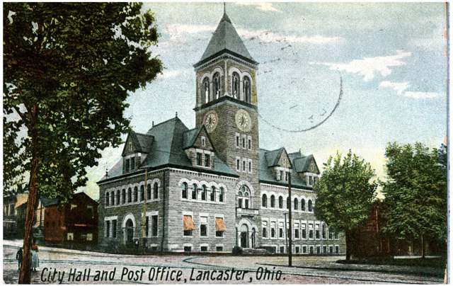
Photo: Columbus Metropolitan Library, via DPLA/Ohio Digital Network, no known copyright restrictions · Wikimedia Commons
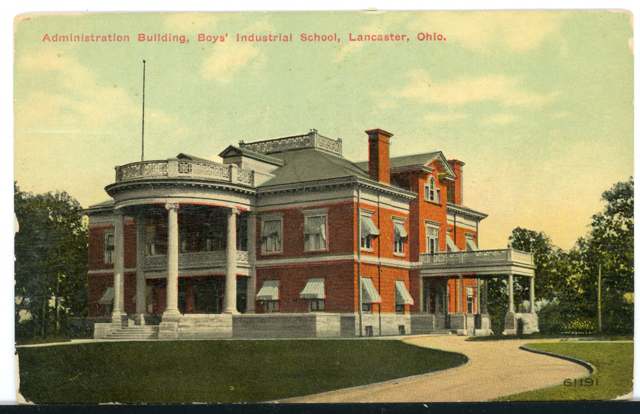
Photo: Columbus Metropolitan Library, via DPLA/Ohio Digital Network, no known copyright restrictions · Wikimedia Commons
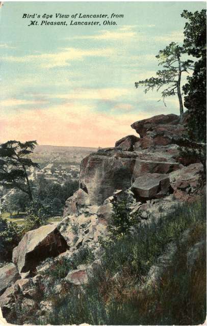
Photo: Columbus Metropolitan Library, via DPLA/Ohio Digital Network, public domain · Wikimedia Commons
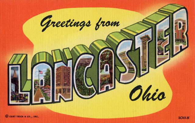
Photo: Steve Shook, via Flickr and Wikimedia Commons, CC BY 2.0 · Wikimedia Commons
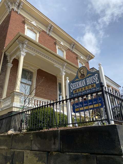
Photo: Zohoe, via Wikimedia Commons, CC BY-SA 4.0 · Wikimedia Commons
Local history sources: archive.org · archive.org · archive.org · en.wikipedia.org · en.wikipedia.org · en.wikipedia.org · en.wikipedia.org · en.wikipedia.org · en.wikipedia.org · en.wikipedia.org · en.wikipedia.org · en.wikipedia.org · en.wikipedia.org · en.wikipedia.org · en.wikipedia.org · firekinggrill.com · shermanhouse.org · sites.google.com · commons.wikimedia.org · commons.wikimedia.org · commons.wikimedia.org · commons.wikimedia.org · commons.wikimedia.org
Water
Miller Park well field (12 wells) drawing groundwater from the Hocking River Valley Aquifer, in Miller Park along N. Memorial Drive north of downtown Lancaster The water here
- Lancaster City97% of residentsHocking River Valley Aquifer (wells)
- Greenfield Twp Water District3% of residentsGroundwater wells (2 wells)
- Sugar Grove Village0% of residentsGroundwater wells (2 wells)
- Brookdale Mobile Home Park0% of residentsGroundwater wells (2 wells)
- Colony Village MHP0% of residentsGroundwater wells (1 wells)
- Fairfield County Utilities0% of residentsLocal groundwater wells (central Ohio, aquifer undocumented)
Its ZIP codes
Each ZIP code that touches Lancaster, with the share of its residents who live here and the same headline figures as the ZIP page.
| ZIP | Share | Water | Radon | Home value | Schools | Flood |
|---|---|---|---|---|---|---|
| 43130 Lancaster | 65% | Miller Park well field (12 wells) drawing groundwater from the Hocking River Valley Aquifer, in Miller Park along N. Memorial Drive north of downtown Lancaster | 8.5 pCi/L average radon | Median year built 1963 | Lancaster City · 3.5 stars overall | 6.2% of residents in the 1% floodplain |
The county
Fairfield County: 13 ZIP codes, 27 cities, villages and townships, 144,692 people.
Nearby places
Cite this page
Cite this page as:
Cracked Buckeye (Open Shower Co), "Lancaster, Fairfield County", https://crackedbuckeye.com/place/lancaster/, built 2026-09-16, accessed [date].
Machine-readable: /api/place/lancaster.json (open JSON, CC BY 4.0 for the compilation; the underlying records keep their own terms) · How to cite · Report a correction · Built 2026-09-16