How Carroll began
Carroll was platted in 1829 in Greenfield Township, on ground picked because the Ohio Canal's builders were about to route the private Lancaster Lateral Canal (the "Side Cut") into the main line at that exact point, and by the mid-1830s the village stood at a genuine three-way water junction: the Ohio Canal, the Side Cut down from Lancaster, and the northern end of the state's own Hocking Canal running south to Nelsonville and Athens. It was named for Charles Carroll of Carrollton, the last surviving signer of the Declaration of Independence, who was still alive and famous when the lots were laid out. The canal trade made it a grain-shipping town for two generations, and the same neighborhood northeast of the village carries three ancient sites -- an Adena burial mound and a pair of Hopewell-era earthworks -- that were added to the National Register of Historic Places together in 1974. Carroll remains a small Greenfield Township village of about 500 people.
Settled Greenfield Township's first cabins went up in 1799; no settlement is recorded on the exact village site before it was platted in 1829, platted 1829, at the point on the Ohio Canal line where the Lancaster Lateral Canal (the "Side Cut") would join it, by William Tong, who laid out the village after the canal reached the site (rendered "William Long" in the 1912 county history).
Where the name comes from
The village was named for Charles Carroll of Carrollton (1737-1832), the Maryland delegate to the Second Continental Congress and, by the time Carroll, Ohio was platted, the last living signer of the Declaration of Independence. No source consulted explains who chose the name or why, only that it honors him.
Before the town
No source names a Native village or camp on the ground Carroll itself occupies, but the surrounding country was Wyandot hunting and living territory before 1795: Fairfield County's principal Wyandot town, Tarhe Town, stood on the Hocking at Lancaster a few miles east, and the nation ceded its claim to the whole valley at the Treaty of Greenville that year, after which most withdrew toward the Sandusky River. The ground immediately northeast of Carroll itself carries a denser and older record. The Coon Hunters Mound, a 5.5-foot Adena burial mound about 65 feet across on Coonpath Road, and, nearby, the Ety Enclosure (a Hopewell-period geometric earthwork) and the Ety Habitation Site (about four acres of low hillocks that yielded large numbers of artifacts from a long-lived Hopewell settlement) were all added to the National Register of Historic Places on the same day, July 12, 1974. Separately, the 1877 county history describes an unexcavated mound "above the rock-mill, seven miles from Lancaster, on the Lithopolis road" as the most important ancient earthwork in the county; whether this is the same mound later registered as Coon Hunters Mound was not confirmed in any source consulted.
Nations recorded here: Wyandot, Adena culture, Hopewell culture.
- Coon Hunters Mound (mound) — 6995 Coonpath Road, near Carroll, Adena culture (roughly 500 BC to AD 400) (en.wikipedia.org)
- Ety Enclosure (earthwork) — northeast of Carroll (exact address restricted), Hopewell culture (en.wikipedia.org)
- Ety Habitation Site (village) — northeast of Carroll, about 4 acres of hillocks, Hopewell culture, roughly two thousand years old (en.wikipedia.org)
- Mound above the Rock Mill (mound) — above the Rock Mill site, seven miles from Lancaster on the old Lithopolis road, Greenfield Township, prehistoric, culture unspecified in the source (archive.org)
Timeline
- — The Treaty of Greenville cedes the Hocking valley, including the future Greenfield Township, and the Wyandot soon withdraw toward the Sandusky River.
- — The first white settlers, including Captain Joseph Stewart, William McFarland and Isaac Meason, arrive in what becomes Greenfield Township.
- — Joseph Loveland and Hezekiah Smith, New Englanders, build a combined grist and saw mill at the forks of the Hocking, a place afterward known as the Rock Mill; they sell whiskey there for a dollar a quart to Indians still passing through.
- — Greenfield Township is formally organized, with its first election held at Yankeetown.
- — A flood destroys the original mill structure at the Rock Mill site (sources disagree on the year).
- — A new mill, five and a half stories tall and framed almost entirely in oak, is built higher up the gorge wall at the Rock Mill site to escape future floods.
- — Carroll is platted by William Tong at the point on the Ohio Canal where the Lancaster Lateral Canal will join it.
- — The Lancaster Lateral Canal Company, organized by Samuel F. McCracken, Jacob Greene, E. Schofield, Benjamin Connell and others, puts its "Side Cut" from Lancaster to Carroll under contract.
- — The Side Cut is completed and the first boats are towed into Lancaster on July 4, celebrated by an estimated ten thousand people at Cold Spring Hill with a roasted ox and free dinner.
- — The State of Ohio buys the Side Cut from the Lancaster Lateral Canal Company for $61,241.04 and folds it into the state-built Hocking Canal running south from Carroll.
- — The Hocking Canal, extended south from the Ohio Canal at Carroll, reaches Nelsonville.
- — The Hocking Canal is completed through to Athens, forty-four miles from Carroll to Monday Creek and on from there.
- — Carroll supports two general stores, a hardware store, two meat markets, two blacksmith shops, a bank, a new $25,000 high school with six teachers, two churches and three physicians.
- — The Coon Hunters Mound, the Ety Enclosure and the Ety Habitation Site, all near Carroll, are listed on the National Register of Historic Places on the same day.
- — Carroll's population is recorded as 501.
Stories
A Town Built for a Junction That Didn't Exist Yet
Carroll was platted in 1829 for a piece of geography that was still under construction: the point where the private Lancaster Lateral Canal Company meant to join its "Side Cut" to the main line of the Ohio Canal. The company, headed by Samuel F. McCracken and Jacob Greene, put the Side Cut under contract in 1832, and it took three more years of digging before the first boats finally passed through to Lancaster on the Fourth of July, 1835 or 1836 -- the old county history itself is not sure which. An estimated ten thousand people, several times the population of Fairfield County's towns put together, gathered at Cold Spring Hill near Lancaster for a roasted ox, cannon fire and a free dinner. Three years later the state bought the whole Side Cut from its private owners for $61,241.04 and extended it south from the Carroll junction as the state's own Hocking Canal, reaching Nelsonville by 1840 and Athens by 1841 -- which meant that for a working generation, a barrel of Fairfield County flour bound for either Lancaster or the Ohio River could pass through no other town but Carroll.
Five and a Half Stories in a Gorge
In 1800, two New Englanders named Joseph Loveland and Hezekiah Smith built a combined grist and saw mill at the forks of the Hocking River in Greenfield Township, hauling in trade goods on pack-horses from Detroit and selling whiskey to the Indians who still passed through at a dollar a quart. A flood washed the original structure out around 1820 or 1822, and its replacement, built in 1824 and still known today as the Rock Mill, was set deliberately higher on the gorge's sandstone wall: five and a half stories of oak framing, with the lower, power-driven levels sunk partly below the rim of the ravine itself. It changed hands through the nineteenth century, was converted from waterpower to steam late in its life, and finally stopped grinding around 1904 or 1905, after which it sat idle for a century until Fairfield County took over the property in 2003 and began restoring it.
Neighbors Two Thousand Years Older Than the Canal
The same stretch of Greenfield Township that later drew canal engineers had already been settled, on and off, for two thousand years before William Tong platted Carroll's first lots. Northeast of the village, an Adena burial mound now called the Coon Hunters Mound rises five and a half feet over a base sixty-five feet across -- never excavated, but presumed by archaeologists to cover the grave of a person of standing, along with whatever tools and ornaments were buried alongside. A short distance away, two later, Hopewell-period sites were recorded: the Ety Enclosure, a geometric earthwork, and the Ety Habitation Site, about four acres of low hillocks that turned out to be the remains of a long-occupied settlement, yielding large numbers of stone and other artifacts before it was ever seriously disturbed by farming or development. All three were added to the National Register of Historic Places on the same day, July 12, 1974, a rare case of one small neighborhood carrying the record of two different mound-building cultures a thousand years apart.
Photographs
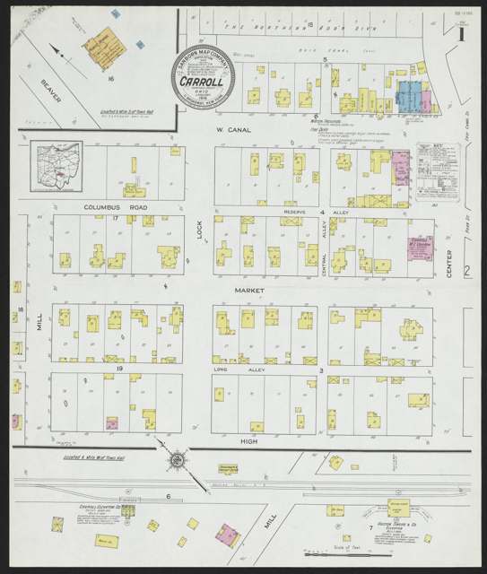
Photo: Kent State University Libraries, via DPLA/Ohio Digital Network, no known copyright restrictions · Wikimedia Commons
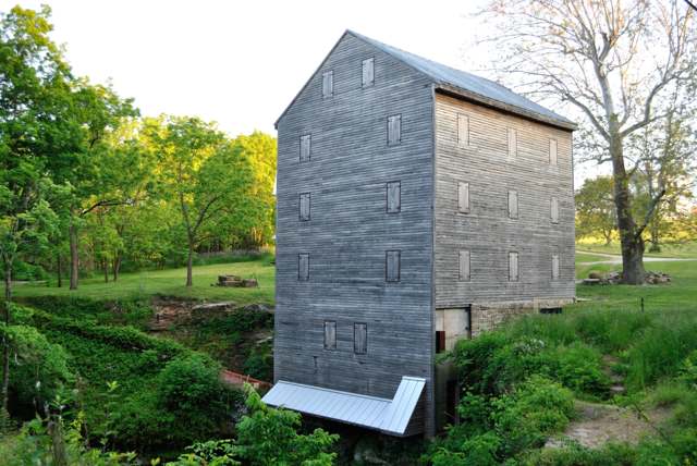
Photo: Wdzinc, via Wikimedia Commons, CC BY-SA 3.0 · Wikimedia Commons
Photo: Nyttend, via Wikimedia Commons, public domain · Wikimedia Commons
Photo: Nyttend, via Wikimedia Commons, public domain · Wikimedia Commons
Local history sources: archive.org · archive.org · archive.org · en.wikipedia.org · en.wikipedia.org · en.wikipedia.org · en.wikipedia.org · en.wikipedia.org · historic-structures.com · commons.wikimedia.org · commons.wikimedia.org · commons.wikimedia.org · commons.wikimedia.org
Water
Mostly private wells The water here
- Carroll Village71% of residentsGroundwater wells (2 wells)
- Fairfield County Utilities19% of residentsLocal groundwater wells (central Ohio, aquifer undocumented)
- Little Walnut Water Treatment Facility10% of residentsGroundwater wells (2 wells)
Its ZIP codes
Each ZIP code that touches Carroll, with the share of its residents who live here and the same headline figures as the ZIP page.
| ZIP | Share | Water | Radon | Home value | Schools | Flood |
|---|---|---|---|---|---|---|
| 43112 Bloom Township and Carroll | 10% | Mostly private wells | 11.6 pCi/L average radon | Median year built 1978 | Bloom Carroll Local · 4 stars overall | 2.3% of residents in the 1% floodplain |
The county
Fairfield County: 13 ZIP codes, 27 cities, villages and townships, 144,692 people.
Nearby places
Cite this page
Cite this page as:
Cracked Buckeye (Open Shower Co), "Carroll, Fairfield County", https://crackedbuckeye.com/place/carroll/, built 2026-09-16, accessed [date].
Machine-readable: /api/place/carroll.json (open JSON, CC BY 4.0 for the compilation; the underlying records keep their own terms) · How to cite · Report a correction · Built 2026-09-16