How Canal Winchester began
Canal Winchester grew from a plat that Reuben Dove and John Colman recorded on November 4-5, 1828, after canal diggers cutting the Ohio and Erie Canal through Dove's wheat field in 1827 talked him out of suing the state and into laying out a town instead, at the midpoint between Columbus and Lancaster. Dove named it Winchester for his family's home town in Virginia; 'Canal' was added in 1841, when the village organized its own post office and took the honor away from the rival settlement of Waterloo. The town began entirely in Violet Township, Fairfield County, and only in 1851 were the village and five surrounding sections annexed into Madison Township, Franklin County, which is why the atlas files Canal Winchester there today - but the city has since grown back east into Fairfield County's Violet and Bloom townships as well, and Fairfield County appears alongside Franklin in the city's own official description of itself. Grain shipped on the canal, then the Hocking Valley Railroad (1869) and the Scioto Valley interurban (1904), built a prosperous 19th- and early-20th-century downtown that survives today as three separate National Register historic districts and a scatter of individually listed houses, churches and mills; the city is now a Columbus-area suburb of about 9,100 people.
Settled 1811, platted 1828, incorporated 1866, by Reuben Dove and John Colman (also recorded as Coleman) platted the village; Dove's father Henry had settled the underlying quarter section.
Where the name comes from
Reuben Dove platted the town on land his father Henry had settled and named it Winchester for Winchester, Virginia, the family's home before they came to Ohio. Sources disagree on exactly when that settlement happened: the National Register nomination for the town says the Doves 'arrived from Winchester in 1811, hence the Winchester name,' while an 1902 township history instead dates Henry Dove's entry of the quarter section to 'about 1802 or 1803.' When the village organized its own post office in 1841, 'Canal' was prefixed to the name - both to distinguish it from five other places called Winchester in Ohio at the time, and, according to the historical marker the village and the Ohio Historical Society later erected on the spot, 'to honor the role the canal played in its development.'
Before the town
Canal Winchester's original plat sits in the Congress Lands, the federal survey district first laid out beginning in 1799 and sold through the land office at Chillicothe; Reuben Dove and John Colman's own 1828 plat describes the town site as 'the southeast quarter of Section 30, Township 15, Range 20... of the land directed to be sold, by an Act of Congress, at Chillicothe.' That survey and sale were possible because the Treaty of Greenville, signed August 3, 1795, had ceded this part of the Scioto valley to the United States (see the Franklin County file for the fuller regional record of prehistoric cultures, historic nations and treaties). Madison Township's 1902 history states plainly that 'no Indian villages were located in this township,' though it notes what 'must have been' a flint-knapping site - 'a flint-worker's shop... in the neighborhood of Asbury Church,' inferred from the number of flint chips found there - and records a Wyandot trail 'leading from To-be-town (Royalton) to Cranetown (Upper Sandusky)' that crossed the farm of an early township settler, Irvin E. Stevenson. Just across the township line in Violet Township, Fairfield County, the same source records that 'the early settlers... remembered a small village of some twenty or thirty wigwams located on the north bank of Little Walnut creek about one mile east of Winchester' - the closest named Native site to the town, though it lay outside the platted village itself, not inside it. No source found in this research ties a named village, camp, burial ground or documented encounter to a specific point inside Canal Winchester's own town plat.
Nations recorded here: Wyandot.
- Wigwam village, Little Walnut Creek (village) — north bank of Little Walnut Creek, about one mile east of Winchester, Violet Township, Fairfield County, remembered by early 19th-century settlers; no date given (archive.org)
- Flint-worker's shop near Asbury Church (other) — neighborhood of Asbury Church, Madison Township, Franklin County, prehistoric, undated; inferred from flint chips found at the site (archive.org)
- Trail from To-be-town to Cranetown (trail) — crossed the farm of Irvin E. Stevenson in Madison Township; ran between To-be-town (near Royalton) and Cranetown (Wyandot chief Tarhe's town, near Upper Sandusky), used before and during early settlement, undated (archive.org)
- Treaty of Greenville cession / Congress Lands survey (treaty) — opened all of the future Canal Winchester site, surveyed as Township 15, Range 20 of the Congress Lands, first surveyed in 1799, treaty signed August 3, 1795; survey from 1799 (en.wikipedia.org)
Timeline
- — Henry Dove, whose family had come from Winchester, Virginia, settles the Congress Lands quarter section that becomes the village site (a conflicting 1902 township history instead dates his entry to 'about 1802 or 1803').
- — Canal diggers cut the Ohio and Erie Canal through Reuben Dove's wheat field; workmen talk him out of suing the state and into laying out a town instead, midway between Columbus and Lancaster.
- — Reuben Dove and John Colman sign a plat for the town of Winchester on November 4 and record it at the Fairfield County courthouse in Lancaster on November 5, surveyed by James O'Kane.
- — The first canal boat floats through Winchester on the newly dug Ohio and Erie Canal.
- — The house at 16 North High Street, later known as the Tallman-Hathaway-Heffley House, is built - one of the earliest documented buildings standing in Canal Winchester today.
- — Winchester organizes its own post office, taking the office from the rival settlement of Waterloo to the east and adding 'Canal' to its name; a local legend, not verified in the sources checked, says two boys dragged Waterloo's post-office building across the street on Halloween night.
- — Canal Winchester and five surrounding sections are annexed from Violet Township, Fairfield County, into Madison Township, Franklin County.
- — Judge John Chaney and his son Oliver P. Chaney build the Empire Mills west of town, called 'one of the best mills in Central Ohio'; it burns down at about midnight on August 23, 1895.
- — After an earlier petition was thrown out on a technicality, the Franklin County commissioners grant Canal Winchester's incorporation on May 31; James B. Evans is elected the village's first mayor that fall.
- — The Columbus and Hocking Valley Railroad reaches Canal Winchester, following two failed subscription drives by local citizens (1853 and 1865-66) to bring a railroad to town.
- — The Columbus Bridge Company builds the Bergstresser (Dietz) covered bridge over Little Walnut Creek for $2,690, using a rare Partridge truss; it is the last covered bridge surviving in Franklin County.
- — The Scioto Valley Traction Company's electric interurban begins running through Canal Winchester, backed by local boosters including Dr. L. W. Beery and village officials such as R. J. Tussing.
- — The Ohio and Erie Canal, whose last boat had reached Canal Winchester in 1901, is formally abandoned after decades of decline hastened by the railroad.
- — The village builds its first water tank (1916) and its municipal waterworks (1917); the waterworks building, remodeled in Tudor Revival style in 1934, is named an American Water Works Association landmark in 1987.
- — Following a 1988 survey by preservation consultant Kathy Mast Kane, Canal Winchester's Columbus Street, West Mound Street and North High Street historic districts and more than a dozen individually listed buildings are added to the National Register of Historic Places on August 15.
Stories
A Wheat Field Becomes a Town
In 1827, work crews cutting the Ohio and Erie Canal reached the wheat field of Reuben Dove, on land his father Henry had settled along what is now High Street. Dove objected to having his crop destroyed and threatened to sue the state for damages. Some of the workmen suggested otherwise: the spot was roughly halfway between Columbus and Lancaster, they told him, and there would be more money in laying out a town than in trying to collect damages. Dove took the advice. In partnership with John Colman, who had bought the adjoining half of the quarter section from Dove's brother Jacob in 1824, he hired surveyor James O'Kane, and on November 4, 1828, the two men signed a plat for a town they named Winchester, after the Virginia town Dove's father had come from; it was recorded at the Fairfield County courthouse in Lancaster the next day. The first canal boat reached the new town in 1831, and by 1841, when Winchester organized its own post office and took the name Canal Winchester to set itself apart from five other Ohio Winchesters, stores and houses were rising along High and Waterloo streets.
The Empire Mills
In 1851 and 1852, Judge John Chaney and his son Oliver P. Chaney built a flour mill a mile west of town and named it the Empire Mills - 'one of the best mills in Central Ohio,' the township history called it. O. P. Chaney had an eye for the business: on a trip to the California gold fields in 1849 he had noticed flour from Chile shipped up the mountains in canvas sacks, and back home he realized small buyers were paying more per pound than those who could afford a whole barrel. He bought muslin, hired women to sew half- and quarter-barrel sacks, and became the first miller in the area to sell flour by the sack instead of the barrel. The mill changed hands several times - Rodenfels, then Rodenfels, Seymour and Company, then Samuel Bartlit - before a new firm bought it in 1894 and built a spur track to the Hocking Valley Railroad. Less than a year later, at about midnight on August 23, 1895, the mill caught fire and burned to the ground along with a covered lattice bridge and a nearby house. While the tail-race was being rebuilt afterward, two Irish workmen returning from an evening in town drowned just below the lock; the next day, while two other men were fishing nearby, one man's hook snagged on something in the water and the corpse of one of the drowned men surfaced beside him.
Incorporating on the Second Try
John Helpman and other citizens petitioned the Franklin County commissioners to incorporate Canal Winchester in January 1866, and a hearing was set for March. When the day came, the commissioners found the petitioners had failed to give legal notice as required, and threw out the whole proceeding. Helpman and the others filed again; a first hearing was continued from May 24 to May 31, 1866, when the commissioners, satisfied this time that notice had been properly given, granted the incorporation and passed it to the county auditor. The village held its first election that fall: James B. Evans became the first mayor, Charles W. Speaks the first recorder, Christian Gayman the first treasurer, and John Chaney, Reuben Trine, John Helpman, Elisha B. Decker and Martin C. Whitehurst the first councilmen. The council's records from its first six years were later lost, but it was in this period that the new village graded its streets and put down its first sidewalks, gutters and sewers.
The Last Covered Bridge in Franklin County
The Columbus Bridge Company built a wooden bridge over Little Walnut Creek south of town in 1887, for $2,690, at a crossing long known as Kramer's Ford after Louis Kramer, who had run a grist and saw mill there since about 1808. The new bridge instead took the name of a different neighbor, Daniel Bergstresser, who owned 79 acres just east of the crossing, and used a Partridge truss - a design rare enough that only six examples are known to survive anywhere. It carried a state highway, Route 674, from the late 1930s until 1956, when the state rerouted the highway and the bridge reverted to Franklin County's care, left open only to the one house and the sewage-treatment plant still served by the old road. The county reshingled its roof in 1971, and the bridge was restored in 1991 and rededicated as the last covered bridge standing anywhere in Franklin County - remembered locally as the Bergstresser-Dietz Bridge.
One of the Earliest Houses in Town
The house at 16 North High Street, built in the late 1830s, is among the earliest documented buildings standing in Canal Winchester, and it shows the same pattern of combined commerce and residence that shaped the town's main streets for a century. William Tallman kept a store there on High Street at the canal through the 1840s and 1850s before moving into the agricultural-implement trade; later residents included George Hathaway, a United Brethren circuit preacher and blacksmith, and James Heffley, who served as pastor of the Reformed church from 1860 to 1871 and then edited The Times newspaper from 1876 to 1881. In 1919, Dr. Louis Saylor, a veterinarian who practiced from North High Street for decades afterward, bought the property and opened his office in the frame building attached to its north side - a wing still in commercial use today. A local contracting firm, the Huffman Brothers, remodeled the main house into a bungalow in 1934, adding dormers and a front porch, though its earlier lines are still visible underneath.
The Oldest School Building in the State
Canal Winchester's school district built a four-room brick schoolhouse on Washington Street in 1862, replacing several smaller buildings that could no longer hold the growing village's children. Seven students made up its first graduating high school class in 1886. As the town grew, so did the school: an addition in 1875, a separate high school building in 1909, a three-story connector between the two in 1929, and elementary wings in 1956 and 1967. In between, the building served the community in other ways too - adult vocational classes in the 1930s and 1950s, agricultural training for returning veterans after the Second World War, and a wartime cannery that ran into 1952. It remains the administrative center of Canal Winchester's schools today and, by the school board's own account, the oldest school building still in use in Ohio. Its exact National Register listing date is disputed between sources: the federal reference number assigned to the building, 07000026, points to a 2007 listing, matching the Wikipedia list of Franklin County's National Register sites, but a historical marker the school board and historical society erected in 2020 states the building was 'added to the National Register of Historic Places in 2017.'
Photographs
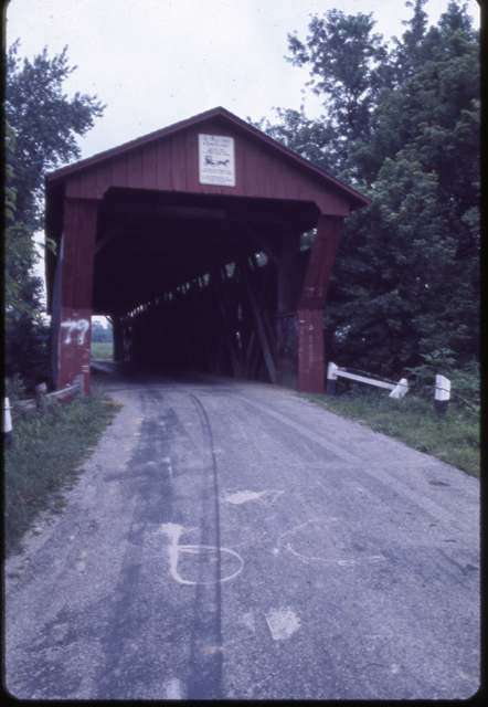
Photo: Columbus Metropolitan Library, via Digital Public Library of America, no known copyright restrictions · Wikimedia Commons
Photo: Wdzinc, CC BY-SA 3.0 · Wikimedia Commons
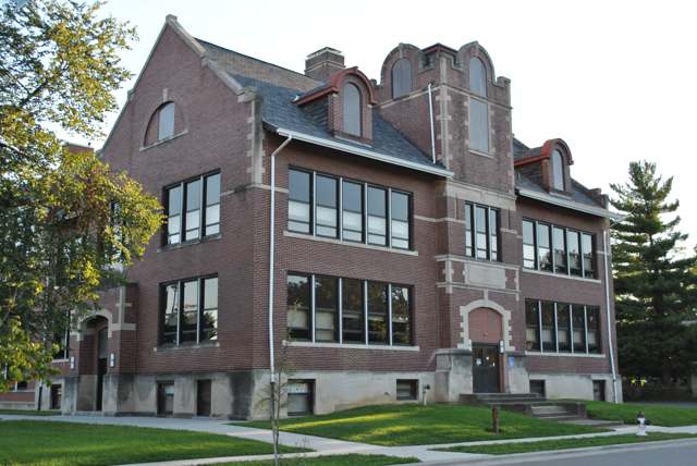
Photo: Wdzinc, CC BY-SA 3.0 · Wikimedia Commons

Photo: Wdzinc, CC BY-SA 3.0 · Wikimedia Commons
Local history sources: en.wikipedia.org · canalwinchesterohio.gov · cwhistory.org · archive.org · ohiogenealogyexpress.com · violet.oh.us · en.wikipedia.org · achp.gov · npgallery.nps.gov · hmdb.org · hmdb.org · hmdb.org · historic-structures.com · en.wikivoyage.org · cwmethodist.com · en.wikipedia.org · commons.wikimedia.org · commons.wikimedia.org · commons.wikimedia.org · commons.wikimedia.org
Water
South Well Field wells in Scioto valley sand and gravel, off Parsons Ave near Shadeville and Lockbourne The water here
- Columbus Public Water System75% of residentsScioto River (Griggs & O'Shaughnessy), Hoover Reservoir on Big Walnut Ck, plus wells
- Canal Winchester City21% of residentsLocal groundwater wells (Franklin Co.)
- Fairfield County Utilities3% of residentsLocal groundwater wells (central Ohio, aquifer undocumented)
- Lithopolis Village0% of residentsGroundwater wells (3 wells)
- Pickerington City0% of residentslocal buried-valley aquifer (wells near Diley Road)
Its ZIP codes
Each ZIP code that touches Canal Winchester, with the share of its residents who live here and the same headline figures as the ZIP page.
| ZIP | Share | Water | Radon | Home value | Schools | Flood |
|---|---|---|---|---|---|---|
| 43110 Columbus and Canal Winchester | 22% | South Well Field wells in Scioto valley sand and gravel, off Parsons Ave near Shadeville and Lockbourne | 7.9 pCi/L average radon | Median year built 2002 | Canal Winchester Local · 4 stars overall | 11% of residents in the 1% floodplain |
The county
Franklin County: 45 ZIP codes, 42 cities, villages and townships, 1,356,733 people.
Nearby places
Cite this page
Cite this page as:
Cracked Buckeye (Open Shower Co), "Canal Winchester, Franklin County", https://crackedbuckeye.com/place/canal-winchester/, built 2026-09-16, accessed [date].
Machine-readable: /api/place/canal-winchester.json (open JSON, CC BY 4.0 for the compilation; the underlying records keep their own terms) · How to cite · Report a correction · Built 2026-09-16