Local events in Greenfield Township, Fairfield County
9 events in the next 90 days from 1 public calendar. All local events in Greenfield Township, Fairfield County
Checked October 20; the events page is refreshed daily.
How Greenfield Township, Fairfield County began
Greenfield Township, immediately northwest of Lancaster, drew some of Fairfield County's very first settlers in 1798 and 1799, who planted three separate neighborhoods at the forks of the Hocking, at Yankeetown, and at the Rock mills, a site the 1883 county history calls the largest ancient earthwork in the county and a longstanding trading rendezvous for Indians from Chillicothe. The township itself was laid out and named for its green fields in 1805. Its village of Carroll grew up at the junction of the Hocking Canal with the Ohio Canal system after the canal era began, and remains the township's trading center; a second canal-era village, Havensport, has nearly vanished. The township is named for open, fertile land rather than for any person.
Settled 1798, platted 1805.
Where the name comes from
The 1883 county history states simply that Greenfield "was laid out in 1805, being named from its green fields," without further explanation. No other source consulted adds to this.
Before the town
Fairfield County's 1883 history places the largest and most interesting ancient earthworks it knew of in the county on a hill in Greenfield Township, a short distance above the upper falls of the Hocking River at the Rock mills: a four-hundred-and-twenty-foot square oriented to the cardinal points, with two circles (125 and 200 feet across) and a small mound inside the smaller circle overlooking the works and the country for miles around. By 1883 the embankments, once about four feet high, had been cleared, leveled and plowed over, destroying most of their value to investigators; no artifacts were recovered from them. The same book's county-wide Indian Tribes chapter says the Rock mills settlement, founded about 1799-1800 by James (or Joseph) Loveland and Hezekiah Smith, was "a favorite center for the Indians," who gathered there seasonally, drawn partly by whiskey the millers sold and partly to trade; the Indians regularly arrived carrying fresh lead of unknown origin, which they would sell but never explain the source of, and exchanged furs for flour, salt, whiskey, tobacco and muslin. Fairfield County lay within the vast 1795 Treaty of Greenville cession, and the Wyandot people held a town called Tarhetown (or Cranetown), after their chief Tarhe, on the site of present Lancaster until the treaty; hunting parties continued visiting the Hocking Valley, Greenfield included, until about 1810-1812. No source consulted names a specific village, trail or burial site inside Greenfield Township's own boundaries apart from the Rock mills earthwork; modern preservation sources place the standing 1824 Rock Mill structure itself across the township line in neighboring Bloom Township, so the earthwork and trading-post narrative that the 1883 county history tells as part of Greenfield's early settlement may describe a site now administratively on the Bloom Township side of the boundary, a discrepancy we could not resolve.
Nations recorded here: Wyandot, Shawnee.
- Rock mills earthwork (earthwork) — on a hill above the upper falls of the Hocking River, described in Greenfield Township in the 1883 county history; modern sources place the surviving Rock Mill structure in neighboring Bloom Township, precontact, mound-builder culture not specified by the source (archive.org)
Timeline
- — The Treaty of Greenville cedes most of what becomes Ohio, including the future Greenfield Township, to the United States; the Wyandot leave their town at the site of Lancaster soon after.
- — The first settlers in this part of the county establish three neighborhoods: at the forks of the Hockhocking, at Yankeetown, and at the Rock mills, among them Isaac Meason, Captain Joseph Steward, Alexander Sanderson and James Wells.
- — James (or Joseph) Loveland and Hezekiah Smith build the first mills in the area, a sawmill and gristmill known as the Loveland Mills (later Rock Mills), and are the first to sell goods in the township, buying their stock in Detroit; the site becomes a seasonal trading rendezvous for Indians from Chillicothe.
- — Levi Steward, son of Captain Joseph Steward, is born, remembered as the first child born in the township.
- — Greenfield Township is laid out and named for its green fields.
- — The Lutherans build the township's first church.
- — Jacob Claypool builds the Greenfield Academy for school and church purposes; Dr. Williams teaches there for about a decade and educates many of the county's leading men.
- — Isaac Havens plats Havensport, a boat station on the canal about a mile and a half northeast of Carroll.
- — The Methodists of Carroll organize under Elijah Dove and Harry Messmore, becoming the largest religious society in the township.
- — The Napthalia Masonic lodge is established in Carroll.
- — Photographer J. J. Wolfe of Lancaster makes a photograph of Blaine's schoolhouse in Greenfield Township, later preserved by the Library of Congress.
Stories
Three Settlements and a Trading Post
Greenfield Township's first white residents in 1798 and 1799 did not settle as one community but as three: a cluster at the forks of the Hockhocking near the Claypool neighborhood, another remembered as Yankeetown, and a third at the Rock mills. The Rock mills settlement grew up around a sawmill and gristmill that two Yankees, James (or Joseph) Loveland and Hezekiah Smith, built about 1799 or 1800, and around the store they stocked with goods hauled down from Detroit. For years afterward the place drew regular visits from Indians coming from as far as Chillicothe, who traded furs for the millers' whiskey, tobacco, flour and muslin, and who reliably reappeared from their hunting camps carrying fresh lead that older residents believed came from a hidden local source no white settler ever located, despite years of searching the hills around the mill and south of Lancaster.
An Earthwork Plowed Away
When the 1883 county history was compiled, its authors judged the ancient works on the hill above Rock mills the largest and most interesting in Fairfield County: a square nearly a football field on a side, oriented to the four points of the compass, joined to two circles of different sizes, one holding a small mound positioned to overlook the whole complex and the countryside beyond. Forest had covered the site until shortly before the book was written, but by 1883 the land had been cleared and the four-foot embankments plowed flat, mixing their distinctively yellow clay into the surrounding soil. No artifacts were ever recovered from the earthwork, and the county historians confessed they could not say who built it or when, only that no such clay occurred naturally nearby.
Carroll at the Canal Junction
Carroll grew up where the Hocking Canal met the main line of the Ohio Canal system, laid out by contractor William Tong after the canal's completion; his own house, part of which still stood in 1883, was the settlement's first building, and he also built the state dam and the first mill before dying before the town was fully laid off. William Breck opened the first store and the first hotel, and for years canal boat traffic was heavy enough that the innkeeper regularly made up beds on the floor to house overflow guests. When railroads replaced canal boats, Carroll's trade in wheat and corn kept the town alive; by 1883 the firm of Saylor & Ebright alone handled about 60,000 bushels of grain a year.
Photographs
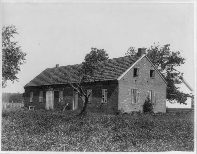
Photo: J. J. Wolfe, Lancaster, Ohio; Library of Congress Prints and Photographs Division, public domain · Wikimedia Commons
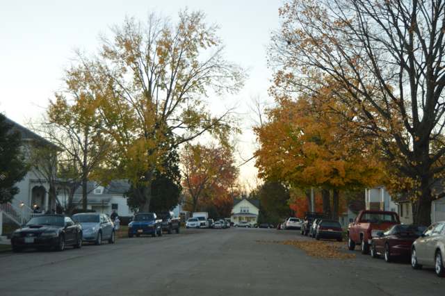
Photo: Nyttend, via Wikimedia Commons, public domain · Wikimedia Commons
Local history sources: archive.org · en.wikipedia.org · en.wikipedia.org · historic-structures.com · en.wikipedia.org · commons.wikimedia.org · commons.wikimedia.org
Water
Mostly private wells The water here
- Lancaster City79% of residentsHocking River Valley Aquifer (wells)
- Carroll Village8% of residentsGroundwater wells (2 wells)
- Baltimore Village7% of residentsGroundwater wells (3 wells)
- Greenfield Twp Water District2% of residentsGroundwater wells (2 wells)
- Fairfield County Utilities2% of residentsLocal groundwater wells (central Ohio, aquifer undocumented)
- Little Walnut Water Treatment Facility1% of residentsGroundwater wells (2 wells)
- Sugar Grove Village0% of residentsGroundwater wells (2 wells)
- Brookdale Mobile Home Park0% of residentsGroundwater wells (2 wells)
- Colony Village MHP0% of residentsGroundwater wells (1 wells)
Hospitals, fire stations and more
Inside Greenfield Township, Fairfield County's boundary: 1 nursing home, 1 fire or EMS station, 3 high-hazard dams, 3 public schools, 1 poor-rated bridge, 1 library, 1 museum, 1 public charging site, 1 Toxics Release Inventory facility and 3 spill cases. Press a pin or a name for its whole record and its source.
Nursing homes (1)
-
Arbors at Carroll4 of 5 stars · Carroll
- Address
- 3680 Dolson Court Nw, Carroll, OH 43112
- Certified beds
- 99
- Residents on an average day
- 92
- Medicare overall rating
- 4 of 5 stars
- Health inspections
- 4 of 5 stars
- Staffing
- 3 of 5 stars
- Quality measures
- 3 of 5 stars
- Penalties since 2023
- none
- Ownership
- For profit - Corporation
- Chain
- ARBORS AT OHIO
- Takes
- Medicare and Medicaid
- Phone
- (740) 654-0641
- Medicare ID
- 365474
Medicare Care Compare ↗ CMS nursing home data (source) ↗ Street map and directions ↗
Source: CMS Care Compare nursing home provider and penalties files; Medicare star ratings run 1 to 5.
Fire and EMS stations (1)
-
Greenfield Township Fire Department Station 560Carroll
- Address
- 3245 Havensport Road, Carroll, OH 43112
- Coordinates
- 39.77340, -82.64741
USGS National Map structures (source) ↗ Street map and directions ↗
Source: USGS National Map structures (most Ohio records last updated 2019 to 2022), checked against the Columbus and Cleveland station lists. The department that answers a call is set by jurisdiction and mutual aid, not by distance.
High-hazard dams (3)
-
Hunters Run Structure No. 6Tributary To Hocking River · condition: fair
- Hazard class
- High: a failure would probably cost a life
- Condition
- Fair (assessed 05/12/2023)
- River or stream
- Tributary To Hocking River
- Purpose
- Flood Risk Reduction
- Type
- Earth
- Height
- 25 ft
- Storage
- 794 acre-feet
- Completed
- 1961
- Owner type
- Local Government
- County
- Fairfield County
- Nearest town (NID)
- Hooker
- Last inspection
- 06/22/2022
- Emergency action plan
- Yes
- NID ID
- OH00721
National Inventory of Dams record ↗ National Inventory of Dams (source) ↗ Street map and directions ↗
-
Hunters Run Structure No. 8Hocking River · condition: satisfactory
- Hazard class
- High: a failure would probably cost a life
- Condition
- Satisfactory (assessed 05/12/2023)
- River or stream
- Hocking River
- Purpose
- Flood Risk Reduction
- Type
- Earth
- Height
- 53 ft
- Storage
- 971 acre-feet
- Completed
- 1959
- Owner type
- Local Government
- County
- Fairfield County
- Nearest town (NID)
- Hooker
- Last inspection
- 06/21/2022
- Emergency action plan
- Yes
- NID ID
- OH00722
National Inventory of Dams record ↗ National Inventory of Dams (source) ↗ Street map and directions ↗
-
Hunters Run Structure No. 9Hocking River · condition: fair
- Hazard class
- High: a failure would probably cost a life
- Condition
- Fair (assessed 05/12/2023)
- River or stream
- Hocking River
- Purpose
- Flood Risk Reduction;Recreation
- Type
- Earth
- Height
- 76 ft
- Storage
- 2,643 acre-feet
- Completed
- 1959
- Owner type
- Local Government
- County
- Fairfield County
- Nearest town (NID)
- Hooker
- Last inspection
- 06/21/2022
- Emergency action plan
- Yes
- NID ID
- OH00714
National Inventory of Dams record ↗ National Inventory of Dams (source) ↗ Street map and directions ↗
Source: U.S. Army Corps of Engineers National Inventory of Dams, August 2026. "High hazard" rates what a failure would cost downstream, not how likely one is; the condition is the state's assessment.
Public schools (3)
-
Bloom Carroll Intermediate School3.5 of 5 stars · Carroll
- Address
- 4955 Carroll Eastern Rd, Carroll, OH 43112
- School district
- Bloom Carroll Local School District
- Kind (NCES)
- Regular School
- Students, 2023-24
- 556
- Teachers (full-time equivalent)
- 25.84
- Report card, 2025-26
- 3.5 of 5 stars
- Performance index
- 83.4%
- Ohio building IRN
- 002857
- NCES school ID
- 390468602676
NCES school record ↗ Ohio School Report Card ↗ Street map and directions ↗
-
Bloom Carroll Primary School3 of 5 stars · Carroll
- Address
- 4955 Carroll Eastern Rd, Carroll, OH 43112
- School district
- Bloom Carroll Local School District
- Kind (NCES)
- Regular School
- Students, 2023-24
- 489
- Teachers (full-time equivalent)
- 23.6
- Report card, 2025-26
- 3 of 5 stars
- Ohio building IRN
- 002907
- NCES school ID
- 390468602679
NCES school record ↗ Ohio School Report Card ↗ Street map and directions ↗
-
Fairfield Career CenterCarroll
- Address
- 3985 Coonpath Rd, Carroll, OH 43112
- Kind (NCES)
- Career and Technical School
- Students, 2023-24
- 577
- Teachers (full-time equivalent)
- 34.06
- NCES school ID
- 390510004285
Source: NCES EDGE public school locations 2024-25 and Common Core of Data 2023-24 (type, students, teachers); Ohio School Report Cards 2025-26 (Department of Education and Workforce), matched by name within the district.
Bridges rated poor (1)
-
Gre-33 Carnes Road over T Walnut Cr(carnes Rd NWPoor · built 1922
- Condition
- Poor: a deck, superstructure, substructure or culvert rated 4 or below on the 0 to 9 scale
- What it is
- Bridge
- Built
- 1922
- Length
- 8 ft
- Owner
- County
- Vehicles a day
- 324
- Coordinates
- 39.80612, -82.69877
National Bridge Inventory (source) ↗ Street map and directions ↗
Source: FHWA National Bridge Inventory 2025. "Poor" means one major part rated 4 or below on the 0 to 9 scale; it calls for repair, not closing, unless the state posts or closes the bridge.
Public libraries (1)
-
Northwest BranchBranch · Carroll
- Address
- 2855 Helena Dr Nw, Carroll, OH 43112
- What it is
- Branch
- Library system
- Fairfield County District Library
- Open
- 2,132 hours a year, 52 weeks
- Building
- 8,200 sq ft
- System's visits, FY2024
- 188,760
- System's loans, FY2024
- 939,640
- People the system serves
- 103,051
- Phone
- (740) 756-4391
IMLS Public Libraries Survey (source) ↗ Street map and directions ↗
Source: IMLS Public Libraries Survey FY2024 (outlets and their systems). Any Ohio resident can get a free card at any Ohio public library.
Museums, historical societies, gardens and zoos (1)
-
Historical Aircraft Squadron MuseumHistory museum · Carroll
- What it is
- History museum
- City
- Carroll
- Coordinates
- 39.75049, -82.66118
Search Wikipedia ↗ IMLS Museum Data Files (source) ↗ Street map and directions ↗
The museum list is IMLS's 2018 file; a museum may have closed or moved since.
Source: IMLS Museum Data Files, 2018.
Public EV charging (1)
-
Bob Boyd Ford - L2 DC fast4 DC fast · 6 Level 2 · Lancaster
- Address
- 2840 North Columbus Street, Lancaster, OH 43130
- Ports
- 4 DC fast · 6 Level 2
- Plugs
- CCS, J1772
- Network
- Blink Network
- Hours
- 24 hours daily
- Phone
- 888-998-2546
Station Locator (NREL) ↗ Alternative Fuels Data Center (source) ↗ Street map and directions ↗
Source: NREL Alternative Fuels Data Center station list (May 2026), public and open stations, the posts at one address counted as one site.
Facilities reporting toxic releases (1)
-
Riviera Cabinets, Inc.Toxics Release Inventory · Lancaster
- Address
- 3200 Old Columbus Rd, Lancaster, OH 43130
- County
- Fairfield County
- Status
- Reports to the Toxics Release Inventory (active)
- EPA program ID
- 43130RVRCB3200O
- EPA registry ID
- 110001623128
EPA facility record ↗ EPA Facility Registry Service (source) ↗ Street map and directions ↗
Source: EPA Facility Registry Service, Toxics Release Inventory reporters. Reporting a release is required of large users of listed chemicals; it is not by itself a violation.
Spills reported since 2021 (3)
-
Fuel Diesel / Diesel Fuel (Vehicle On Or Off Road)2025-06-04 · Greenfield Twp
- Reported
- 2025-06-04
- What spilled
- Fuel Diesel / Diesel Fuel (Vehicle On Or Off Road)
- Largest amount reported
- 150 gallons
- Where
- Greenfield Twp, Fairfield County
- Ohio EPA district office
- CDO
- Ohio EPA case number
- 2506EPA0000906
Ohio EPA spill reports (source) ↗ Street map and directions ↗
-
Material Blue Reached water2024-08-23 · Greenfield Twp
- Reported
- 2024-08-23
- What spilled
- Material Blue
- Reached a waterway
- 99 - Unnamed
- Where
- Greenfield Twp, Fairfield County
- Ohio EPA district office
- CDO
- Ohio EPA case number
- 2408EPA0001461
Ohio EPA spill reports (source) ↗ Street map and directions ↗
-
Fish Kill Reached water2023-08-05 · Greenfield Twp
- Reported
- 2023-08-05
- What spilled
- Fish Kill
- Reached a waterway
- Greenville Creek
- Where
- Greenfield Twp, Fairfield County
- Ohio EPA district office
- CDO
- Ohio EPA case number
- 2308EPA0001337
Ohio EPA spill reports (source) ↗ Street map and directions ↗
Source: Ohio EPA emergency response spill reports, 2021 to September 2026, one point per case where Ohio EPA placed it. A report is what the caller or responder recorded; amounts are often blank or estimated.
Its ZIP codes
Each ZIP code that touches Greenfield Township, Fairfield County, with the share of its residents who live here and the same headline figures as the ZIP page.
| ZIP | Share | Water | Radon | Home value | Schools | Flood |
|---|---|---|---|---|---|---|
| 43112 Bloom Township and Carroll | 35% | Mostly private wells | 11.6 pCi/L average radon | Median year built 1978 | Bloom Carroll Local · 4 stars overall | 2.3% of residents in the 1% floodplain |
| 43105 Liberty Township and Baltimore | 5% | Mostly private wells | 7.3 pCi/L average radon | Median year built 1975 | Liberty Union-Thurston Local · 4 stars overall | 6.3% of residents in the 1% floodplain |
| 43130 Lancaster | 5% | North Water Treatment Plant, a new 9.3 MGD firm-capacity reverse-osmosis plant reported in service 2026, which replaced the retired approximately 1925 Miller Park Water Plant. Draws on the Miller Park well field (12 wells), used since 1932, in Miller Park along N. Memorial Drive north of downtown Lancaster. | 8.5 pCi/L average radon | Median year built 1963 | Lancaster City · 3.5 stars overall | 6.2% of residents in the 1% floodplain |
Local government
Who holds office in Greenfield Township, Fairfield County, how its elections and ballot issues came out, and the state auditor's record.
Money issues on the ballot since 2022: 1 of 1 passed.
Ballot issues
| Date | Issue | For | Against | Result |
|---|---|---|---|---|
| 2022-05-03 | Issue: Greenfield Township Tax Levy | 643 | 520 | Passed (55.29% for) |
Elections for office
| Date | Office | Candidates and votes |
|---|---|---|
| 2023-11-07 | Township Trustee | David R. Cotner 1,146, 65.49%; Ronnie G. Wyne 604, 34.51% |
| 2023-11-07 | Township Fiscal Officer | Jessica Kull 1,123, 63.92%; Dawn R. Wyne 634, 36.08% |
Winners in bold. Results from the county board of elections' official canvass unless marked.
Auditor of State record
- No fiscal caution, watch or emergency on the Auditor of State's lists.
- OP&F Examination, 2023, released 2025-05-15
- Financial Audit, 2022 to 2023, released 2024-11-07
The county
Fairfield County: 13 ZIP codes, 27 cities, villages and townships, 144,692 people.
Nearby places
Quick answers
What county is Greenfield Township, Ohio in?
Greenfield Township, Fairfield County is a township in Fairfield County, Ohio, with 5,204 residents.
When was Greenfield Township, Ohio founded?
Greenfield Township, Fairfield County was settled 1798; laid out 1805. Source
How did Greenfield Township, Ohio get its name?
The 1883 county history states simply that Greenfield "was laid out in 1805, being named from its green fields," without further explanation. Source
What ZIP code is Greenfield Township, Ohio?
Greenfield Township, Fairfield County is served by ZIP codes 43112, 43105 and 43130; 43112 holds the largest share of its residents.
Where does Greenfield Township, Ohio get its water?
The main water source for Greenfield Township, Fairfield County (Lancaster City): Mostly private wells.
Cite this page
Cite this page as:
Cracked Buckeye, "Greenfield Township, Fairfield County", https://crackedbuckeye.com/place/greenfield-township-fairfield-county/, built 2026-10-31, accessed [date].
How to cite · Report a correction · Built 2026-10-31
