Local events in Stock Township, Noble County
Nothing is posted for Stock Township itself yet; here is what is on within 20 miles. All local events in Stock Township, Noble County
Know a calendar we should watch? Send the link
Checked October 20; the events page is refreshed daily.
How Stock Township, Noble County began
Stock Township lies in the eastern part of Noble County and was carved, along with most of the county, from Monroe County territory when Noble County was organized on March 11, 1851. Its first settlers worked the East Fork of Duck Creek in the early 1800s, among them the Enoch, Crow, Grandon, Morris and Archer families; the 1887 county history records that the last Indian camp in that part of the country was a hunting party's camp on Sailor's Run in 1812. One of the township's two villages, East Union, grew out of the 1803-04 "Archer settlement," said to be the site of the first permanent Roman Catholic settlement in Ohio, and was formally platted in 1856. A small post-office hamlet called Cliffyville served farm families on Crum Ridge Road along Mallet Creek from 1887 to 1914. Today Stock Township remains agricultural and unincorporated, with a 2020 population of 312.
Settled 1803-1804 (Archer settlement, later East Union), platted 1856 (East Union), by Archer, Enoch, Crow, Grandon and Morris families; township organized with Noble County, March 11, 1851.
Where the name comes from
Wikipedia's article on the township records only that Stock Township was formed from Monroe County territory in 1851, without giving a name origin, and notes that the only other Stock Township in Ohio is in Harrison County. No source we found explains why the name 'Stock' was chosen.
Before the town
No mounds, earthworks, villages or treaty lines specific to Stock Township are recorded in the sources consulted. The 1887 county history's Stock Township chapter says the last Indian camp in that part of the country stood on Sailor's Run, a stream flowing into Duck Creek about two miles below Carlisle: a party of Indian hunters occupied it in 1812, and none were seen there after that year, all having left the country to engage in the war. The history does not name the hunters' nation. The broader Native history of the region includes the nations who hunted and traveled this section of the upper Ohio valley, and the treaties (Greenville, 1795, among others) that opened it to settlement.
- Last Indian camp on Sailor's Run (camp) — Sailor's Run, a stream flowing into Duck Creek about two miles below Carlisle, Stock Township, 1812 (archive.org)
Timeline
- — Families from Wheeling Creek in Greene County, Pennsylvania, and the Wheeling area, the Enochs, Crows, Grandons and Morrises, make one of the earliest settlements in what is now Noble County on the East Fork of Duck Creek; Elisha Enochs settles near the site of Carlisle.
- — The Archer family and others, including at least one Catholic household, settle what becomes known as the Archer settlement, later the site of East Union; the settlement is described as the first permanent Roman Catholic settlement in Ohio.
- — Henry Enochs, born March 27, is believed to be the first white child born in the township.
- — A party of Indian hunters camps on Sailor's Run, below Carlisle; the 1887 county history calls it the last Indian camp in that part of the country.
- — A list of taxpayers shows the Archers, Enochs, Bernard Grandon and others as the landholders of the township.
- — German immigration begins about this year; by 1887 there are about forty-five German voters.
- — Noble County is organized from parts of Guernsey, Monroe, Morgan and Washington counties on March 11; the area that becomes Stock Township is transferred from Monroe County.
- — The Noble County commissioners erect Stock Township on May 1; the first election, held July 12, chooses Reuben Wood justice of the peace.
- — East Union, in the northwestern part of the township, is formally platted.
- — A post office named Cliffyville opens on Crum Ridge Road along Mallet Creek, serving the Crum, Mallet and Morrison families of the area; it remains in operation until 1914.
- — The census counts 312 people in the township.
Stories
A Catholic settlement on the frontier
Around 1803 or 1804, a group of families that included at least one Catholic household settled the East Fork country that would become northwestern Stock Township. Local and state historical writing (Ohio History, the Ohio Historical Society's journal, April 1915) identifies this as the Archer settlement, and credits it as the earliest permanent Roman Catholic settlement in the state of Ohio, predating the county itself by nearly half a century. The settlement's northern portion later grew into the platted village of East Union in 1856, while its southern reach extended toward what became Crumtown in neighboring Elk Township. The distinction is a notable one for so small and thinly documented a township, and it ties Stock Township's founding directly to the wider story of Catholic migration into the Ohio country in the early republic.
The last camp on Sailor's Run
Sailor's Run, a stream about two miles below Carlisle, is named for Jacob Sailor, an early settler whose wife, Esther Crow, was a sister of the Crow girls killed by Indians near Wheeling in 1791. The 1887 county history says the last Indian camp in this part of the country stood on Sailor's Run and was occupied by a party of Indian hunters in 1812; none were ever seen there after that year, all of them leaving the country to engage in the war. The Crow family were among the township's earliest settlers on the East Fork of Duck Creek. The history tells how on Easter Sunday 1791, near Ryerson's Station on Wheeling Creek in Greene County, Pennsylvania, three Indians stopped four Crow sisters on their way to the block-house; two were found scalped and dead the next day, a third died nine days later, and the youngest, Tenah, escaped with a blow to the back and later married John McBride, who owned the land on which Carlisle stands. Their brother Martin Crow, who settled near Carlisle, was a lifelong enemy of the Indians and a hunter for the surveyors of the first seven ranges.
Photographs
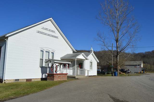
Photo: Nyttend, public domain · Wikimedia Commons
Local history sources: en.wikipedia.org · en.wikipedia.org · en.wikipedia.org · archive.org · ohioghosttowns.wordpress.com · commons.wikimedia.org · commons.wikimedia.org · archive.org · archive.org
Water
Mostly private wells The water here
- Caldwell Village56% of residentsWolf Run Lake (primary) + Caldwell Lake (backup reservoirs)
- Clear Water Corporation29% of residentsWolf Run Lake (primary) + Caldwell Lake (backup reservoirs)
- Pure Water Corporation8% of residentsWolf Run Lake (primary) + Caldwell Lake (backup reservoirs)
- Noble County Water Authority3% of residentsWolf Run Lake (primary) + Caldwell Lake (backup reservoirs)
- Pure Water System 22% of residentsWolf Run Lake (primary) + Caldwell Lake (backup reservoirs)
- Noble Water Company1% of residentsWolf Run Lake (primary) + Caldwell Lake (backup reservoirs)
Hospitals, fire stations and more
Inside Stock Township, Noble County's boundary: 4 poor-rated bridges and 7 shale and injection wells. Press a pin or a name for its whole record and its source.
Bridges rated poor (4)
-
County Road 6 over East ForkPoor · built 1900
- Condition
- Poor: a deck, superstructure, substructure or culvert rated 4 or below on the 0 to 9 scale
- What it is
- Bridge
- Built
- 1900
- Length
- 16 ft
- Owner
- County
- Vehicles a day
- 385
- Coordinates
- 39.76994, -81.39965
National Bridge Inventory (source) ↗ Street map and directions ↗
-
Township Road 236 over Duck CreekPoor · built 1900
- Condition
- Poor: a deck, superstructure, substructure or culvert rated 4 or below on the 0 to 9 scale
- What it is
- Bridge
- Built
- 1900
- Length
- 23 ft
- Owner
- County
- Vehicles a day
- 96
- Coordinates
- 39.69471, -81.35305
National Bridge Inventory (source) ↗ Street map and directions ↗
-
Township Road 263 over East Fork Duck CreekPoor · built 1900
- Condition
- Poor: a deck, superstructure, substructure or culvert rated 4 or below on the 0 to 9 scale
- What it is
- Culvert
- Built
- 1900
- Length
- 15 ft
- Owner
- County
- Vehicles a day
- 96
- Coordinates
- 39.71619, -81.36023
National Bridge Inventory (source) ↗ Street map and directions ↗
-
Township Road 533 over East ForkPoor · built 1900
- Condition
- Poor: a deck, superstructure, substructure or culvert rated 4 or below on the 0 to 9 scale
- What it is
- Bridge
- Built
- 1900
- Length
- 21 ft
- Owner
- County
- Vehicles a day
- 96
- Coordinates
- 39.73590, -81.36004
National Bridge Inventory (source) ↗ Street map and directions ↗
Source: FHWA National Bridge Inventory 2025. "Poor" means one major part rated 4 or below on the 0 to 9 scale; it calls for repair, not closing, unless the state posts or closes the bridge.
Shale and injection wells (7)
-
Alabaster St Nbl 1 1HUtica shale well
- What it is
- Utica shale well
- Drilled sideways
- Yes
- Operator
- Ascent Resources Utica Llc
- County
- Noble County
- API well number
- 34121243420100
- Coordinates
- 39.75205, -81.34265
ODNR oil and gas wells (source) ↗ Street map and directions ↗
The point is the surface well head (the pad); a horizontal well runs a mile or more underground from it.
-
Duane Weisend East 6HUtica shale well
- What it is
- Utica shale well
- Drilled sideways
- Yes
- Operator
- Expand Operating Llc
- County
- Noble County
- API well number
- 34121246000000
- Coordinates
- 39.77531, -81.32344
ODNR oil and gas wells (source) ↗ Street map and directions ↗
The point is the surface well head (the pad); a horizontal well runs a mile or more underground from it.
-
Duane Weisend East 8HUtica shale well
- What it is
- Utica shale well
- Drilled sideways
- Yes
- Operator
- Expand Operating Llc
- County
- Noble County
- API well number
- 34121245990000
- Coordinates
- 39.77526, -81.32350
ODNR oil and gas wells (source) ↗ Street map and directions ↗
The point is the surface well head (the pad); a horizontal well runs a mile or more underground from it.
-
Duane Weisend Unit 4HUtica shale well
- What it is
- Utica shale well
- Drilled sideways
- Yes
- Operator
- Expand Operating Llc
- County
- Noble County
- API well number
- 34121244700100
- Coordinates
- 39.77514, -81.32355
ODNR oil and gas wells (source) ↗ Street map and directions ↗
The point is the surface well head (the pad); a horizontal well runs a mile or more underground from it.
-
Winston Smith St Nbl 36 2HUtica shale well
- What it is
- Utica shale well
- Drilled sideways
- Yes
- Operator
- Ascent Resources Utica Llc
- County
- Noble County
- API well number
- 34121245100000
- Coordinates
- 39.75805, -81.39198
ODNR oil and gas wells (source) ↗ Street map and directions ↗
The point is the surface well head (the pad); a horizontal well runs a mile or more underground from it.
-
Winston Smith St Nbl 36 4HUtica shale well
- What it is
- Utica shale well
- Drilled sideways
- Yes
- Operator
- Ascent Resources Utica Llc
- County
- Noble County
- API well number
- 34121245090000
- Coordinates
- 39.75811, -81.39198
ODNR oil and gas wells (source) ↗ Street map and directions ↗
The point is the surface well head (the pad); a horizontal well runs a mile or more underground from it.
-
Winston Smith St Nbl 36 6HUtica shale well
- What it is
- Utica shale well
- Drilled sideways
- Yes
- Operator
- Ascent Resources Utica Llc
- County
- Noble County
- API well number
- 34121245080000
- Coordinates
- 39.75816, -81.39199
ODNR oil and gas wells (source) ↗ Street map and directions ↗
The point is the surface well head (the pad); a horizontal well runs a mile or more underground from it.
Source: ODNR Division of Oil and Gas Resources well inventory (September 2026): drilled Utica, Marcellus and horizontal wells and Class II injection wells not plugged. Older vertical wells are on the full map.
Its ZIP codes
Each ZIP code that touches Stock Township, Noble County, with the share of its residents who live here and the same headline figures as the ZIP page.
| ZIP | Share | Water | Radon | Home value | Schools | Flood |
|---|---|---|---|---|---|---|
| 43788 Marion Township and Summerfield | 16% | Mostly private wells | Too few radon tests | Appraisal records without year built | Noble Local · 3.5 stars overall | 2.9% of residents in the 1% floodplain |
| 43779 Center Township and Sarahsville | 8% | Mostly private wells | Too few radon tests | Appraisal records without year built | Noble Local · 3.5 stars overall | 2.5% of residents in the 1% floodplain |
| 43724 Olive Township and Caldwell | 1% | Mostly private wells | 8.2 pCi/L average radon | Appraisal records without year built | Caldwell Exempted Village · 3 stars overall | 2.8% of residents in the 1% floodplain |
Local government
Who holds office in Stock Township, Noble County, how its elections and ballot issues came out, and the state auditor's record.
Elections for office
| Date | Office | Candidates and votes |
|---|---|---|
| 2021-11-02 | Township Trustee | Randy Archer 69, 61.61%; Robert Forshey 43, 38.39% |
| 2019-11-05 | Township Trustee | Duane Ed Dimmerling 59, 53.15%; Dale Feldner 52, 46.85% |
| 2019-11-05 | Township Fiscal Officer | Evelyn Diane Brown 56, 50.0%; Andrea Hall 56, 50.0% |
Winners in bold. Results from the county board of elections' official canvass unless marked.
Auditor of State record
- No fiscal caution, watch or emergency on the Auditor of State's lists.
- Basic Audit, 2023 to 2024, released 2025-09-23
The county
Noble County: 6 ZIP codes, 14 cities, villages and townships, 11,290 people.
Nearby places
Quick answers
What county is Stock Township, Ohio in?
Stock Township, Noble County is a township in Noble County, Ohio, with 312 residents.
When was Stock Township, Ohio founded?
Stock Township, Noble County was settled 1803-1804 (Archer settlement, later East Union); laid out 1856 (East Union). Founders on record: Archer, Enoch, Crow, Grandon and Morris families; township organized with Noble County, March 11, 1851. Source
How did Stock Township, Ohio get its name?
Wikipedia's article on the township records only that Stock Township was formed from Monroe County territory in 1851, without giving a name origin, and notes that the only other Stock Township in Ohio is in Harrison County. Source
What ZIP code is Stock Township, Ohio?
Stock Township, Noble County is served by ZIP codes 43788 and 43779; 43788 holds the largest share of its residents.
Where does Stock Township, Ohio get its water?
The main water source for Stock Township, Noble County (Caldwell Village): Mostly private wells.
Cite this page
Cite this page as:
Cracked Buckeye, "Stock Township, Noble County", https://crackedbuckeye.com/place/stock-township-noble-county/, built 2026-10-31, accessed [date].
How to cite · Report a correction · Built 2026-10-31
