Local events in Sarahsville
Nothing is posted for Sarahsville itself yet; here is what is on within 20 miles. All local events in Sarahsville
Know a calendar we should watch? Send the link
Checked October 20; the events page is refreshed daily.
Lakes near Sarahsville
The history under the water: the valley before, the dam, the stories. All Ohio lakes
How Sarahsville began
Sarahsville, named for Sarah Devold, wife of an early settler, was the original seat of Noble County when the county was organized on March 11, 1851, a status it held only until 1858, when a contested relocation moved the county offices to Caldwell after litigation. A post office has run there since 1840; by 1833 the settlement had one store, six dwellings and about thirty residents, and it later served as a tobacco trading center into the late 1880s. Population peaked near 300 in 1890 and has declined since, standing at 147 in the 2020 census. The Young-Shaw House, a two-and-a-half-story 1870 farmhouse just east of the village on State Route 146, was listed on the National Register of Historic Places in 1980 but has since been demolished.
Settled 1833.
Where the name comes from
The village was named for Sarah Devold, the wife of an early settler.
Before the town
No source we found records a Native American village, camp, trail, or burial site specifically within Sarahsville or Center Township. The Noble County history covers what is recorded about Native peoples in the county generally.
Timeline
- — Sarahsville is recorded with one store, six dwelling houses, and about thirty inhabitants.
- — A post office named Sarahsville begins operating in the village.
- — On March 11, Noble County is organized from parts of Guernsey, Monroe, Morgan and Washington counties, and Sarahsville is designated the county seat.
- — The Democratic Courier newspaper begins publishing at Sarahsville.
- — After a legal dispute between Sarahsville and a rival site known as "the Caldwell Farm," the county seat and county offices are moved to Caldwell.
- — The Young-Shaw farmhouse, a two-and-a-half-story balloon-framed house with five agricultural outbuildings, is built east of the village on the road that became State Route 146.
- — Sarahsville's population reaches 306, its recorded peak.
- — The Young-Shaw House is listed on the National Register of Historic Places (reference #80003203) on February 8; it has since been demolished.
Stories
The county seat that lasted seven years
When Noble County was carved out of Guernsey, Monroe, Morgan and Washington counties on March 11, 1851 -- the last of Ohio's eighty-eight counties to be formed -- Sarahsville, already an established village with its own newspaper, the Democratic Courier, was named the county seat. The choice did not sit well with residents elsewhere in the new county, and a rival group pushed for a more central site on what was known as "the Caldwell Farm." The fight went to court, and the challengers won: in 1858 the county offices were moved to the new town of Caldwell, which has been the county seat ever since. Sarahsville kept its post office, its churches, and its place as a farming and tobacco-trading village, but the county courthouse it briefly held never returned.
Photographs
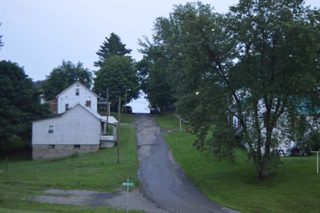
Photo: Nyttend, public domain · Wikimedia Commons
Local history sources: en.wikipedia.org · en.wikipedia.org · freepages.rootsweb.com · archive.org · commons.wikimedia.org · commons.wikimedia.org
Water
Mostly private wells The water here
- Clear Water Corporation100% of residentsWolf Run Lake (primary) + Caldwell Lake (backup reservoirs)
Hospitals, fire stations and more
Inside Sarahsville's boundary: 1 poor-rated bridge. Press a pin or a name for its whole record and its source.
Bridges rated poor (1)
-
Mill Road over Buffalo CreekPoor · built 1948
- Condition
- Poor: a deck, superstructure, substructure or culvert rated 4 or below on the 0 to 9 scale
- What it is
- Bridge
- Built
- 1948
- Length
- 16 ft
- Owner
- City
- Vehicles a day
- 100
- Coordinates
- 39.80506, -81.47171
National Bridge Inventory (source) ↗ Street map and directions ↗
Source: FHWA National Bridge Inventory 2025. "Poor" means one major part rated 4 or below on the 0 to 9 scale; it calls for repair, not closing, unless the state posts or closes the bridge.
Its ZIP codes
Each ZIP code that touches Sarahsville, with the share of its residents who live here and the same headline figures as the ZIP page.
| ZIP | Share | Water | Radon | Home value | Schools | Flood |
|---|---|---|---|---|---|---|
| 43779 Center Township and Sarahsville | 14% | Mostly private wells | Too few radon tests | Appraisal records without year built | Noble Local · 3.5 stars overall | 2.5% of residents in the 1% floodplain |
Local government
Who holds office in Sarahsville, how its elections and ballot issues came out, and the state auditor's record.
Auditor of State record
- No fiscal caution, watch or emergency on the Auditor of State's lists.
- Basic Audit, 2023 to 2024, released 2025-11-20
The county
Noble County: 6 ZIP codes, 14 cities, villages and townships, 11,290 people.
Nearby places
Rain and snow
How much has actually fallen on Sarahsville, day by day, from 1887 to now. Daily totals, not averages.
- rain, last 30 days
- 2.17 in
- 2026-09-29 to 2026-10-28
- rain so far in 2026
- 48.9 in
- 11.8 in above normal for the date
- snow so far in 2026
- 18.5 in
- a normal year brings 21.0 in
- a normal year
- 43.8 in
- average of 30 years, 1991-2020
| Month | Rain (in) | Snow (in) | Days counted |
|---|---|---|---|
| October 2026 | 2.17 | — | 28 |
| September 2026 | 5.24 | — | 30 |
| August 2026 | 9.13 | — | 31 |
| July 2026 | 5.25 | — | 31 |
| June 2026 | 5.37 | — | 30 |
| May 2026 | 6.81 | — | 31 |
| April 2026 | 3.70 | — | 30 |
| March 2026 | 7.64 | 3.4 | 31 |
| February 2026 | 1.36 | 2.4 | 28 |
| January 2026 | 2.24 | 12.7 | 31 |
| December 2025 | 2.53 | 8.4 | 31 |
| November 2025 | 2.20 | 0.3 | 30 |
| Wettest year | 2018 — 59.1 in |
|---|---|
| Driest year | 1930 — 23.4 in |
| Snowiest year | 1910 — 59.8 in |
| Wettest day on record | 14 July 1913 — 4.41 in |
| Heaviest snowfall in a day | 9 November 1913 — 12.81 in |
| Deepest snow on the ground | 27 November 1950 — 19.58 in |
Estimated, not measured. No rain gauge has ever stood inside Sarahsville, so every figure here is worked out from the gauges around it - the nearest ones weighted most. Treat them as close estimates rather than readings.
49,680 days of records, 1887-08-01 to 2026-10-28. Source: NOAA NCEI GHCN-Daily, 3,240 gauges in and around Ohio. A day is "gauged" when a gauge standing inside the boundary reported it, and the value is the mean of those gauges. Otherwise it is interpolated by inverse distance from every gauge reporting within 50 miles. Nothing is carried forward, back-filled or smoothed. Against NOAA nClimDiv county monthly precipitation over 136,848 complete county-months (checked 2026-10-31): correlation 0.9515, median absolute difference 0.217 in a month. Built 2026-10-31 from the Cracked Buckeye precipitation archive. Snow is the softer number — snowfall is measured by hand with a ruler, no agency publishes a gridded county snowfall series, and blowing snow defeats every observer.
Environmental permits and filings
What Ohio EPA has on file for Sarahsville: permits, inspections, violations, cleanups and the state loans behind sewer and water work. Every line links to the agency's own document.
- facilities and sites on file
- 2
- those placed on the map inside Sarahsville
| Program | Facilities and sites |
|---|---|
| State sewer loans | 1 |
| Wastewater and stormwater discharge | 1 |
| Date | Facility or site | What |
|---|---|---|
| I-77 EAST WATER MAIN EXTENSION-PHASE 5 | Wastewater and stormwater discharge permit | |
| SARAHSVILLE SANITARY SEWER AND WWTP | State sewer loans |
Source: Ohio EPA eDocument portal (edocpub.epa.ohio.gov), indexed 2026-10-14. Facilities are placed on the map from Ohio EPA's own map layers, EPA's Facility Registry, coordinates written in the filings, or a geocoded street address. A permit filed under a private person's name (most are household septic systems) is counted but never named, placed or linked; licenses for individual workers and open-burning notices are left out entirely.
Quick answers
What county is Sarahsville, Ohio in?
Sarahsville is a village in Noble County, Ohio, with 139 residents.
When was Sarahsville, Ohio founded?
Sarahsville was settled 1833. Source
How did Sarahsville, Ohio get its name?
The village was named for Sarah Devold, the wife of an early settler. Source
What ZIP code is Sarahsville, Ohio?
Most of Sarahsville is in ZIP code 43779.
Where does Sarahsville, Ohio get its water?
The main water source for Sarahsville (Clear Water Corporation): Mostly private wells.
Cite this page
Cite this page as:
Cracked Buckeye, "Sarahsville, Noble County", https://crackedbuckeye.com/place/sarahsville/, built 2026-10-31, accessed [date].
How to cite · Report a correction · Built 2026-10-31
