Local events in South Euclid
76 events in the next 90 days from 1 public calendar. All local events in South Euclid
Checked October 20; the events page is refreshed daily.
How South Euclid began
South Euclid grew out of Euclid Township, organized in 1809 and divided into nine numbered sections (South Euclid was district two) in 1828. Bluestone quarrying, run at two sites consolidated by the Forest City Stone Company in the 1870s, gave the town's northern end the name Bluestone village and was its economic mainstay through the 19th century before concrete construction displaced stone. Residents voted to break from Euclid Township and incorporate as their own village on October 13, 1917, absorbing Bluestone village in the process; South Euclid became a city in 1941, aided by Depression-era WPA funding, and its population boomed after World War II as Cleveland families moved outward, peaking in the early 1970s. The Sisters of Notre Dame's Notre Dame College operated in South Euclid from 1922 until closing in May 2024, and its 1927 Tudor Revival Administration Building remains on the National Register of Historic Places in a city of about 21,900.
Platted 1809 (Euclid Township organized); 1828 (divided into nine sections, South Euclid as district two), incorporated 1917-10-13 (village); 1941 (city), by Residents of Euclid Township's second district.
Where the name comes from
South Euclid takes its name from its position as the southern portion of the original Euclid Township, itself named in 1797 by Moses Cleaveland's survey party for the ancient Greek mathematician Euclid of Alexandria.
Before the town
No source we reviewed names a specific Native American village, trail or burial site within present South Euclid. Wikipedia's article on South Euclid states that the area became part of the Connecticut Western Reserve through an 1796 treaty involving the Iroquois, though we could not independently confirm the specific treaty referenced (it does not match the dates of the 1785 Treaty of Fort McIntosh or the 1795 Treaty of Greenville, which secured the wider region, and may instead refer to a separate right-of-way negotiation the Connecticut Land Company's surveyors conducted with Native people before their 1796 expedition).
Timeline
- — Euclid Township is formally organized.
- — Euclid Township is divided into nine numbered sections; the future South Euclid becomes district two.
- — The Forest City Stone Company consolidates two bluestone quarry sites in the township's north end, making it one of the region's largest stone producers and giving the area the name Bluestone village.
- — Residents vote to incorporate as the village of South Euclid, separating from Euclid Township and absorbing Bluestone village.
- — Edward C. Foote is elected South Euclid's first mayor.
- — The Sisters of Notre Dame found Notre Dame College in South Euclid as a women's college.
- — Notre Dame College's Tudor Revival Administration Building, designed by Thomas D. McLaughlin, is built.
- — South Euclid becomes a city, its growth aided by Depression-era WPA funding.
- — South Euclid's population peaks amid postwar suburban growth from Cleveland.
- — Notre Dame College's Administration Building is listed on the National Register of Historic Places.
- — Notre Dame College becomes coeducational.
- — Notre Dame College closes after more than a century in South Euclid.
Stories
The bluestone town that became a village on its own terms
Through most of the 19th century, South Euclid's northern end was known locally as Bluestone village, for the stone quarried there at two sites the Forest City Stone Company consolidated into one of the region's largest producers in the 1870s -- a working landscape of quarry pits and stoneworkers' housing rather than the residential suburb that came later. As concrete construction spread and undercut demand for cut bluestone, the district's identity shifted, and in 1917 residents of Euclid Township's southern section, Bluestone included, voted to break away and incorporate as their own village, electing Edward C. Foote mayor within weeks. The transition from quarry town to independent municipality set the pattern for the next century: South Euclid grew into a full city by 1941 and then boomed after World War II as Cleveland families moved outward, its population peaking in the early 1970s on land that, a century before, had been valued mainly for what could be cut out of it.
A century of Notre Dame in South Euclid
The Sisters of Notre Dame opened Notre Dame College in South Euclid in 1922 as a women's liberal arts college, and by 1927 had built its Tudor Revival Administration Building, designed by architect Thomas D. McLaughlin, on College Road -- a building striking enough to earn its own National Register of Historic Places listing in 1983. The college stayed a women's institution for eight decades before going coeducational in 2001, continuing to serve South Euclid students for more than another twenty years. Like many small liberal arts colleges nationally, it could not outlast the enrollment pressures of the 2020s, and closed for good on May 2, 2024, after 102 years -- leaving its landmark administration building standing in South Euclid without the college that built it.
Photographs
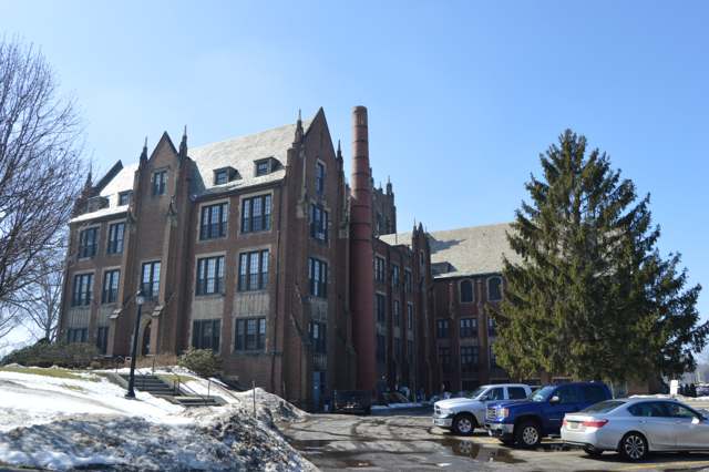
Photo: Nyttend (Wikimedia Commons), public domain · Wikimedia Commons
Local history sources: en.wikipedia.org · en.wikipedia.org · commons.wikimedia.org
Historic places
2 places in South Euclid on the National Register of Historic Places. Press a pin or a name for its whole record.
-
Notre Dame College of OhioBuilding · South Euclid · listed 1983
- Address
- 4545 College Rd.
- Where
- South Euclid, Cuyahoga County · ZIP 44121
- What it is
- Building
- Listed on the National Register
- 1983
- NRIS reference number
- 83004267
- Coordinates
- 41.50771, -81.51545
National Register file (NPS) ↗ Search Wikipedia ↗ Street map and directions ↗ On the Cracked Buckeye map
-
Telling, William E., HouseBuilding · South Euclid · listed 1974
- Address
- 4645 Mayfield Rd.
- Where
- South Euclid, Cuyahoga County · ZIP 44121
- What it is
- Building
- Listed on the National Register
- 1974
- NRIS reference number
- 74001463
- Coordinates
- 41.52015, -81.51267
National Register file (NPS) ↗ Search Wikipedia ↗ Street map and directions ↗ On the Cracked Buckeye map
Source: National Park Service, National Register of Historic Places point file. The listing year is shown where NPS's certification date agrees with the listing's reference number. Listing recognizes significance; it does not restrict a private owner.
Water
The Five Mile Crib, a small structure about 5 miles out in Lake Erie north of Cleveland's Edgewater Park The water here
- Cleveland Public Water System100% of residentsLake Erie
Hospitals, fire stations and more
Inside South Euclid's boundary: 1 dialysis center, 1 fire or EMS station, 4 public schools, 1 private school, 1 library, 2 museums, 1 police station, 5 public charging sites, 1 Toxics Release Inventory facility and 2 spill cases. Press a pin or a name for its whole record and its source.
Dialysis centers (1)
-
Concerto OhioDialysis · South Euclid
- Address
- 2111 South Green Road, South Euclid, OH 44121
- Dialysis stations
- 1
- Medicare star rating
- not rated
- Services
- peritoneal dialysis, home hemodialysis training
- Ownership
- for profit
- Chain
- independent
- Medicare certified since
- 2021-01-05
- Phone
- (847) 233-1200
- Medicare ID
- 362897
Medicare Care Compare ↗ CMS dialysis facility list (source) ↗ Street map and directions ↗
Source: CMS dialysis facility list, September 2026, geocoded with the Census Bureau batch geocoder (an address it could not place sits at its ZIP center).
Fire and EMS stations (1)
-
South Euclid Fire DepartmentSouth Euclid
- Address
- 1349 South Green Road, South Euclid, OH 44121
- Coordinates
- 41.52346, -81.51880
USGS National Map structures (source) ↗ Street map and directions ↗
Source: USGS National Map structures (most Ohio records last updated 2019 to 2022), checked against the Columbus and Cleveland station lists. The department that answers a call is set by jurisdiction and mutual aid, not by distance.
Public schools (4)
-
Adrian Elementary School4.5 of 5 stars · South Euclid
- Address
- 1071 Homestead Rd, South Euclid, OH 44121
- School district
- South Euclid-Lyndhurst City School District
- Kind (NCES)
- Regular School
- Students, 2023-24
- 271
- Teachers (full-time equivalent)
- 17.15
- Report card, 2025-26
- 4.5 of 5 stars
- Performance index
- 86.5%
- Ohio building IRN
- 000232
- NCES school ID
- 390447901642
NCES school record ↗ Ohio School Report Card ↗ Street map and directions ↗
-
Greenview School3 of 5 stars · South Euclid
- Address
- 1825 S Green Rd, South Euclid, OH 44121
- School district
- South Euclid-Lyndhurst City School District
- Kind (NCES)
- Regular School
- Students, 2023-24
- 658
- Teachers (full-time equivalent)
- 39.25
- Report card, 2025-26
- 3 of 5 stars
- Performance index
- 70.1%
- Ohio building IRN
- 014613
- NCES school ID
- 390447904386
NCES school record ↗ Ohio School Report Card ↗ Street map and directions ↗
-
Memorial Junior High School3 of 5 stars · Cleveland
- Address
- 1250 Professor Rd, Cleveland, OH 44124
- School district
- South Euclid-Lyndhurst City School District
- Kind (NCES)
- Regular School
- Students, 2023-24
- 481
- Teachers (full-time equivalent)
- 30.4
- Report card, 2025-26
- 3 of 5 stars
- Performance index
- 59%
- Ohio building IRN
- 024216
- NCES school ID
- 390447901648
NCES school record ↗ Ohio School Report Card ↗ Street map and directions ↗
-
Rowland Elementary School3 of 5 stars · South Euclid
- Address
- 4300 Bayard Rd, South Euclid, OH 44121
- School district
- South Euclid-Lyndhurst City School District
- Kind (NCES)
- Regular School
- Students, 2023-24
- 443
- Teachers (full-time equivalent)
- 30.25
- Report card, 2025-26
- 3 of 5 stars
- Performance index
- 65.7%
- Ohio building IRN
- 032821
- NCES school ID
- 390447901650
NCES school record ↗ Ohio School Report Card ↗ Street map and directions ↗
Source: NCES EDGE public school locations 2024-25 and Common Core of Data 2023-24 (type, students, teachers); Ohio School Report Cards 2025-26 (Department of Education and Workforce), matched by name within the district.
Private schools (1)
-
Lyceum- ThePrivate, Catholic · South Euclid
- Address
- Po Box 21466, South Euclid, OH 44121
- Kind
- Catholic
- Students, 2023-24
- 53
- Teachers (full-time equivalent)
- 11.6
- Students per teacher
- 4.56897
- Phone
- (216) 707-1121
- NCES private school ID
- A1502921
Source: NCES Private School Survey 2023-24.
Public libraries (1)
-
South Euclid/Lyndhurst Branch LibraryBranch · South Euclid
- Address
- 1876 South Green Road, South Euclid, OH 44121
- What it is
- Branch
- Library system
- Cuyahoga County Public Library
- Open
- 3,501 hours a year, 52 weeks
- Building
- 30,030 sq ft
- System's visits, FY2024
- 3,917,784
- System's loans, FY2024
- 11,584,178
- People the system serves
- 626,288
- Phone
- (216) 382-4880
IMLS Public Libraries Survey (source) ↗ Street map and directions ↗
Source: IMLS Public Libraries Survey FY2024 (outlets and their systems). Any Ohio resident can get a free card at any Ohio public library.
Museums, historical societies, gardens and zoos (2)
-
South Euclid Historical SocietyHistorical society · South Euclid
- What it is
- Historical society
- City
- South Euclid
- Coordinates
- 41.51983, -81.51318
Search Wikipedia ↗ IMLS Museum Data Files (source) ↗ Street map and directions ↗
The museum list is IMLS's 2018 file; a museum may have closed or moved since.
-
United States Aviation MuseumHistory museum · South Euclid
- What it is
- History museum
- City
- South Euclid
- Coordinates
- 41.50375, -81.51829
Search Wikipedia ↗ IMLS Museum Data Files (source) ↗ Street map and directions ↗
The museum list is IMLS's 2018 file; a museum may have closed or moved since.
Source: IMLS Museum Data Files, 2018.
Police stations (1)
-
South Euclid Police DepartmentSouth Euclid
- Address
- 1349 South Green Road, South Euclid, OH 44121
- Coordinates
- 41.52331, -81.51885
USGS National Map structures (source) ↗ Street map and directions ↗
Source: USGS National Map structures, police stations, corrected and completed by hand (September 2026). The department that answers a call is set by jurisdiction, not by distance.
Public EV charging (5)
-
SOUTH EUCLID BEXLEY PARK2 Level 2 · South Euclid
- Address
- 1630 Wrenford Rd, South Euclid, OH 44121
- Ports
- 2 Level 2
- Plugs
- J1772
- Network
- ChargePoint Network
- Hours
- 24 hours daily
- Phone
- 888-758-4389
Station Locator (NREL) ↗ Alternative Fuels Data Center (source) ↗ Street map and directions ↗
-
SOUTH EUCLID CENTER #22 Level 2 · South Euclid
- Address
- 1370 Victory Dr, South Euclid, OH 44121
- Ports
- 2 Level 2
- Plugs
- J1772
- Network
- ChargePoint Network
- Hours
- 24 hours daily
- Phone
- 888-758-4389
Station Locator (NREL) ↗ Alternative Fuels Data Center (source) ↗ Street map and directions ↗
-
SOUTH EUCLID COMMUNITY CENT2 Level 2 · South Euclid
- Address
- 1370 Victory Drive, South Euclid, OH 44121
- Ports
- 2 Level 2
- Plugs
- J1772
- Network
- ChargePoint Network
- Hours
- 24 hours daily
- Phone
- 888-758-4389
Station Locator (NREL) ↗ Alternative Fuels Data Center (source) ↗ Street map and directions ↗
-
SOUTH EUCLID QUARRY PARK2 Level 2 · South Euclid
- Address
- 711 S Belvoir Blvd, South Euclid, OH 44121
- Ports
- 2 Level 2
- Plugs
- J1772
- Network
- ChargePoint Network
- Hours
- 24 hours daily
- Phone
- 888-758-4389
Station Locator (NREL) ↗ Alternative Fuels Data Center (source) ↗ Street map and directions ↗
-
SOUTH EUCLID QUARRY PARK S22 Level 2 · South Euclid
- Address
- 711 South Belvoir Boulevard, South Euclid, OH 44121
- Ports
- 2 Level 2
- Plugs
- J1772
- Network
- ChargePoint Network
- Hours
- 24 hours daily
- Phone
- 888-758-4389
Station Locator (NREL) ↗ Alternative Fuels Data Center (source) ↗ Street map and directions ↗
Source: NREL Alternative Fuels Data Center station list (May 2026), public and open stations, the posts at one address counted as one site.
Facilities reporting toxic releases (1)
-
Röchling Industrial Cleveland (1318544510)Toxics Release Inventory · South Euclid
- Address
- 4321 Glenridge Road, South Euclid, OH 44121
- County
- Cuyahoga County
- Status
- Reports to the Toxics Release Inventory (active)
- EPA program ID
- 44121THGLS4321G
- EPA registry ID
- 110000387340
EPA facility record ↗ EPA Facility Registry Service (source) ↗ Street map and directions ↗
Source: EPA Facility Registry Service, Toxics Release Inventory reporters. Reporting a release is required of large users of listed chemicals; it is not by itself a violation.
Spills reported since 2021 (2)
-
Fuel Gasoline ( 25% Ethanol Not E85)2025-06-17 · South Euclid
- Reported
- 2025-06-17
- What spilled
- Fuel Gasoline ( 25% Ethanol Not E85)
- Where
- South Euclid, Cuyahoga County
- Ohio EPA district office
- NEDO
- Ohio EPA case number
- 2506EPA0000997
Ohio EPA spill reports (source) ↗ Street map and directions ↗
-
Sewage Human Reached water2023-05-12 · South Euclid
- Reported
- 2023-05-12
- What spilled
- Sewage Human
- Reached a waterway
- 99 - Unnamed
- Where
- South Euclid, Cuyahoga County
- Ohio EPA district office
- NEDO
- Ohio EPA case number
- 2305EPA0000773
Ohio EPA spill reports (source) ↗ Street map and directions ↗
Source: Ohio EPA emergency response spill reports, 2021 to September 2026, one point per case where Ohio EPA placed it. A report is what the caller or responder recorded; amounts are often blank or estimated.
Its ZIP codes
Each ZIP code that touches South Euclid, with the share of its residents who live here and the same headline figures as the ZIP page.
| ZIP | Share | Water | Radon | Home value | Schools | Flood |
|---|---|---|---|---|---|---|
| 44121 South Euclid and Cleveland | 59% | The Five Mile Crib, a small structure about 5 miles out in Lake Erie north of Cleveland's Edgewater Park | 1.8 pCi/L average radon | Median year built 1949 | South Euclid-Lyndhurst City · 3 stars overall | 1.1% of residents in the 1% floodplain |
| 44118 Cleveland Heights and Cleveland | 4% | The Five Mile Crib, a small structure about 5 miles out in Lake Erie north of Cleveland's Edgewater Park | 1.3 pCi/L average radon | Median year built 1934 | Cleveland Heights-University Heights City · 3.5 stars overall | 0.0% of residents in the 1% floodplain |
| 44143 Richmond Heights and Cleveland | 3% | Lake Erie, through a 10-foot tunnel running nearly 4 miles offshore from northeast Cleveland's lakefront | 2.8 pCi/L average radon | Median year built 1969 | Mayfield City · 5 stars overall | 1.0% of residents in the 1% floodplain |
Local government
Who holds office in South Euclid, how its elections and ballot issues came out, and the state auditor's record.
Auditor of State record
- No fiscal caution, watch or emergency on the Auditor of State's lists.
- Financial Health Indicators (the Auditor of State's 17 measures; critical / cautionary / positive): 2019 0 / 1 / 16; 2020 0 / 4 / 13; 2021 0 / 3 / 14; 2022 0 / 0 / 17; 2023 1 / 0 / 16; 2024 0 / 1 / 16.
- Financial Audit, 2025, released 2026-09-15
- OPERS Examination, 2025, released 2026-05-19
- Financial Audit, 2024, released 2025-09-04
- Financial Audit, 2023, released 2024-08-13
The county
Cuyahoga County: 52 ZIP codes, 59 cities, villages and townships, 1,270,867 people.
Nearby places
Rain and snow
How much has actually fallen on South Euclid, day by day, from 1871 to now. Daily totals, not averages.
- rain, last 30 days
- 1.96 in
- 2026-09-29 to 2026-10-28
- rain so far in 2026
- 33.8 in
- about normal for the date
- snow so far in 2026
- 41.6 in
- a normal year brings 65.8 in
- a normal year
- 42.5 in
- average of 27 years, 1991-2020
| Month | Rain (in) | Snow (in) | Days counted |
|---|---|---|---|
| October 2026 | 1.96 | — | 28 |
| September 2026 | 3.60 | — | 30 |
| August 2026 | 7.28 | — | 31 |
| July 2026 | 2.04 | — | 31 |
| June 2026 | 2.80 | — | 30 |
| May 2026 | 3.83 | — | 31 |
| April 2026 | 5.75 | — | 30 |
| March 2026 | 3.52 | 1.9 | 31 |
| February 2026 | 0.62 | 8.6 | 28 |
| January 2026 | 2.44 | 31.1 | 31 |
| December 2025 | 3.15 | 18.2 | 31 |
| November 2025 | 2.38 | 10.3 | 30 |
| Wettest year | 2011 — 68.0 in |
|---|---|
| Driest year | 1963 — 20.9 in |
| Snowiest year | 1996 — 121.3 in |
| Wettest day on record | 3 February 1883 — 3.62 in |
| Heaviest snowfall in a day | 25 December 2020 — 16.18 in |
| Deepest snow on the ground | 14 November 1996 — 32.99 in |
Mostly estimated. Only 2% of these days come from a gauge standing inside South Euclid - the rest are worked out from the nearest gauges around it, so read them as close estimates rather than readings.
52,726 days of records, 1871-01-01 to 2026-10-28. Source: NOAA NCEI GHCN-Daily, 3,240 gauges in and around Ohio. A day is "gauged" when a gauge standing inside the boundary reported it, and the value is the mean of those gauges. Otherwise it is interpolated by inverse distance from every gauge reporting within 50 miles. Nothing is carried forward, back-filled or smoothed. Against NOAA nClimDiv county monthly precipitation over 136,848 complete county-months (checked 2026-10-31): correlation 0.9515, median absolute difference 0.217 in a month. Built 2026-10-31 from the Cracked Buckeye precipitation archive. Snow is the softer number — snowfall is measured by hand with a ruler, no agency publishes a gridded county snowfall series, and blowing snow defeats every observer.
Environmental permits and filings
What Ohio EPA has on file for South Euclid: permits, inspections, violations, cleanups and the state loans behind sewer and water work. Every line links to the agency's own document.
- facilities and sites on file
- 46
- those placed on the map inside South Euclid
| Program | Facilities and sites |
|---|---|
| Voluntary cleanup | 24 |
| Hazardous waste | 12 |
| Wastewater and stormwater discharge | 5 |
| Air pollution | 2 |
| Contaminated-site cleanup | 1 |
| Sewer and water-line construction | 1 |
| Site assessment | 1 |
| Date | Facility or site | What |
|---|---|---|
| GLASTIC CORP CLEVELAND FAC | Voluntary cleanup inspection | |
| CEDAR CTR PLAZA FORMER EUCLID | Voluntary cleanup inspection | |
| BLANCHE AVE | Wastewater and stormwater discharge permit | |
| GLASTIC CORP CLEVELAND FAC | Voluntary cleanup inspection | |
| CUBE SMART - SOUTH EUCLID | Voluntary cleanup covenant | |
| ST JOHN WOODS | Wastewater and stormwater discharge permit | |
| ROECHLING INDUSTRIAL CLEVELAND LP | Air pollution inspection | |
| PIR 3963 - ARDMORE AND PLAINFIELD | Wastewater and stormwater discharge permit | |
| GLASTIC CORP CLEVELAND FAC | Voluntary cleanup inspection | |
| CEDAR CTR PLAZA FORMER EUCLID | Voluntary cleanup compliance letter | |
| CEDAR CTR PLAZA FORMER EUCLID | Voluntary cleanup covenant | |
| CEDAR CTR PLAZA FORMER EUCLID | Voluntary cleanup inspection | |
| GLASTIC CORP CLEVELAND FAC | Voluntary cleanup inspection | |
| CEDAR CTR PLAZA FORMER EUCLID | Voluntary cleanup inspection | |
| CEDAR CTR PLAZA FORMER EUCLID | Voluntary cleanup inspection | |
| CEDAR CTR PLAZA FORMER EUCLID | Voluntary cleanup inspection | |
| ST. JOHN WOODS | Sewer and water-line construction permit | |
| CUBE SMART - SOUTH EUCLID | Voluntary cleanup covenant | |
| ST. JOHN WOODS | Sewer and water-line construction permit | |
| ST JOHN WOODS | Wastewater and stormwater discharge permit | |
| CEDAR CTR PLAZA FORMER EUCLID | Voluntary cleanup inspection | |
| CUBE SMART - SOUTH EUCLID | Voluntary cleanup covenant | |
| ST JOHN MEADOWS | Wastewater and stormwater discharge permit | |
| ST. JOHN WOODS | Sewer and water-line construction permit | |
| CUBE SMART - SOUTH EUCLID | Voluntary cleanup covenant |
Source: Ohio EPA eDocument portal (edocpub.epa.ohio.gov), indexed 2026-10-14. Facilities are placed on the map from Ohio EPA's own map layers, EPA's Facility Registry, coordinates written in the filings, or a geocoded street address. A permit filed under a private person's name (most are household septic systems) is counted but never named, placed or linked; licenses for individual workers and open-burning notices are left out entirely.
Quick answers
What county is South Euclid, Ohio in?
South Euclid is a city in Cuyahoga County, Ohio, with 21,883 residents.
When was South Euclid, Ohio founded?
South Euclid was laid out 1809 (Euclid Township organized); 1828 (divided into nine sections, South Euclid as district two); incorporated 1917-10-13 (village); 1941 (city). Founders on record: Residents of Euclid Township's second district. Source
How did South Euclid, Ohio get its name?
South Euclid takes its name from its position as the southern portion of the original Euclid Township, itself named in 1797 by Moses Cleaveland's survey party for the ancient Greek mathematician Euclid of Alexandria. Source
What ZIP code is South Euclid, Ohio?
South Euclid is served by ZIP codes 44121, 44118 and 44143; 44121 holds the largest share of its residents.
Where does South Euclid, Ohio get its water?
The main water source for South Euclid (Cleveland Public Water System): The Five Mile Crib, a small structure about 5 miles out in Lake Erie north of Cleveland's Edgewater Park.
Cite this page
Cite this page as:
Cracked Buckeye, "South Euclid, Cuyahoga County", https://crackedbuckeye.com/place/south-euclid/, built 2026-10-31, accessed [date].
How to cite · Report a correction · Built 2026-10-31
