University Heights
City · Cuyahoga County · 13,914 residents · 2.5% municipal income tax
Local events in University Heights
96 events in the next 90 days from 2 public calendars. All local events in University Heights
Checked October 20; the events page is refreshed daily.
Notable people from University Heights
Ohioans tied to this place, each with a sourced profile. All notable Ohioans
How University Heights began
University Heights was part of Warrensville Township before incorporating in 1908 as the village of Idlewood, a sleepy community whose population actually fell from 221 in 1910 to 131 in 1920. In the mid-1920s, anticipating that the Jesuit-run John Carroll University would relocate there from Cleveland's Ohio City neighborhood, the village renamed itself University Heights -- a bet that paid off explosively: the university's 1931-1935 move to a new Collegiate Gothic campus, anchored by Philip L. Small's Saint Ignatius Hall, sent the village's population up more than 1,600 percent in a decade, from 131 in 1920 to 2,237 in 1930, and it became a city in 1940. By 1950 the city held 11,566 people. University Heights remains built around John Carroll University today, with the school's North Quad Historic District, including Saint Ignatius Hall, listed on the National Register of Historic Places, in a city of about 13,900.
Incorporated 1908 (village of Idlewood); 1940 (city).
Where the name comes from
The village incorporated in 1908 as Idlewood and renamed itself University Heights in the mid-1920s in anticipation of John Carroll University relocating there from Cleveland's Ohio City neighborhood -- a bet on a still-uncompleted move that the university's arrival soon justified.
Before the town
No source we reviewed names a specific Native American village, trail or burial site within present University Heights. The area lies within the Connecticut Western Reserve, secured for settlement by the 1785 Treaty of Fort McIntosh and the 1795 Treaty of Greenville.
Timeline
- — The Society of Jesus founds St. Ignatius College in Cleveland, the future John Carroll University.
- — The village of Idlewood incorporates out of Warrensville Township.
- — Idlewood's population is 221.
- — The village's population has fallen to 131; it renames itself University Heights around this time in anticipation of John Carroll University's relocation.
- — Architect Philip L. Small designs Saint Ignatius Hall, the Collegiate Gothic centerpiece of John Carroll University's new University Heights campus, as the university moves from Ohio City; its former high school division stays downtown as Saint Ignatius High School.
- — University Heights' population reaches 2,237, a more than sixteenfold increase over 1920.
- — University Heights, with a population of 5,981, becomes a city.
- — University Heights' population reaches 11,566.
- — The John Carroll University North Quad Historic District, including Saint Ignatius Hall, is listed on the National Register of Historic Places.
Stories
A village that renamed itself for a university that hadn't moved in yet
By 1920 the village of Idlewood was, if anything, shrinking -- its population had fallen from 221 to just 131 over the previous decade, a sleepy corner of Warrensville Township with no obvious reason to grow. What changed its fortunes was a bet on the future: sometime in the mid-1920s, with word that the Jesuit-run John Carroll University was planning to leave its cramped Ohio City campus in Cleveland, the village renamed itself University Heights before the university had actually finished moving. The gamble paid off completely. Architect Philip L. Small's Collegiate Gothic Saint Ignatius Hall, built 1931 to 1935 as the new campus's centerpiece, anchored a relocation that sent the surrounding village's population up more than sixteenfold in a single decade -- 131 people in 1920, 2,237 by 1930 -- and by 1940 the growth was large enough for University Heights to become a city outright. Few Ohio communities have staked, and won, so much of their identity on a single institution's real estate decision.
Photographs
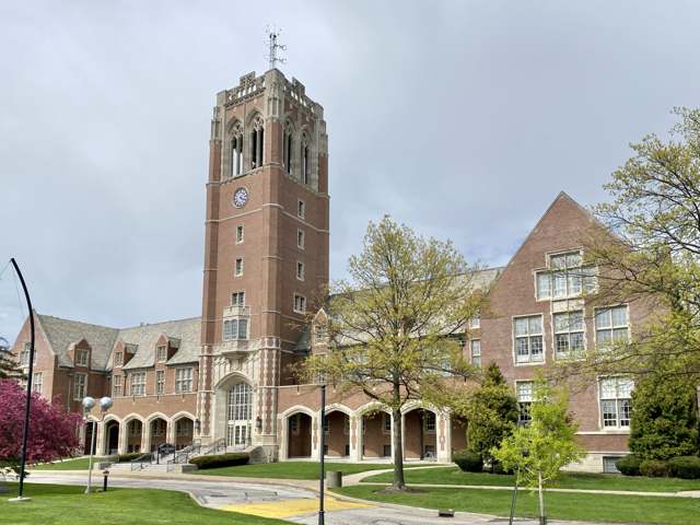
Photo: Warren LeMay (Wikimedia Commons, via Flickr), CC BY-SA 2.0 · Wikimedia Commons
Local history sources: en.wikipedia.org · en.wikipedia.org · commons.wikimedia.org
Water
The Five Mile Crib, a small structure about 5 miles out in Lake Erie north of Cleveland's Edgewater Park The water here
- Cleveland Public Water System100% of residentsLake Erie
Hospitals, fire stations and more
Inside University Heights's boundary: 1 fire or EMS station, 1 college, 1 public school, 1 private school, 1 library, 2 police stations, 1 public charging site and 4 spill cases. Press a pin or a name for its whole record and its source.
Fire and EMS stations (1)
-
University Heights Fire DepartmentUniversity Heights
- Address
- 3980 Silsby Road, University Heights, OH 44118
- Coordinates
- 41.49738, -81.53685
USGS National Map structures (source) ↗ Street map and directions ↗
Source: USGS National Map structures (most Ohio records last updated 2019 to 2022), checked against the Columbus and Cleveland station lists. The department that answers a call is set by jurisdiction and mutual aid, not by distance.
Colleges (1)
-
John Carroll UniversityPrivate nonprofit college · University Heights
- What it is
- Private nonprofit college
- City
- University Heights
- Students, 2023-24 (12-month count)
- 3,041
- Tuition and fees, in state
- $49,100
- Graduation rate
- 76% of bachelor's students, within six years (a class of 753)
- IPEDS unit ID
- 203368
College Navigator (NCES) ↗ IPEDS data (source) ↗ Street map and directions ↗
Source: NCES IPEDS 2024 directory, 2023-24 enrollment and tuition, graduation rates for the 2017 (four-year) and 2020 (two-year) entering classes.
Public schools (1)
-
Gearity Professional Development School3 of 5 stars · University Hts
- Address
- 2323 Wrenford Rd, University Hts, OH 44118
- School district
- Cleveland Hts-Univ Hts City School District
- Kind (NCES)
- Regular School
- Students, 2023-24
- 382
- Teachers (full-time equivalent)
- 26
- Report card, 2025-26
- 3 of 5 stars
- Performance index
- 66.3%
- Ohio building IRN
- 002352
- NCES school ID
- 390437900565
NCES school record ↗ Ohio School Report Card ↗ Street map and directions ↗
Source: NCES EDGE public school locations 2024-25 and Common Core of Data 2023-24 (type, students, teachers); Ohio School Report Cards 2025-26 (Department of Education and Workforce), matched by name within the district.
Private schools (1)
-
Gesu SchoolPrivate, Catholic · University Heights
- Address
- 2450 Miramar Blvd, University Heights, OH 44118
- Kind
- Catholic
- Students, 2023-24
- 639
- Teachers (full-time equivalent)
- 39.6
- Students per teacher
- 16.1364
- Phone
- (216) 932-0620
- NCES private school ID
- 01059086
Source: NCES Private School Survey 2023-24.
Public libraries (1)
-
University Heights Branch LibraryBranch · University Heights
- Address
- 13866 Cedar Rd., University Heights, OH 44118
- What it is
- Branch
- Library system
- Cleveland Heights-University Heights Pl
- Open
- 2,782 hours a year, 52 weeks
- Building
- 17,593 sq ft
- System's visits, FY2024
- 510,120
- System's loans, FY2024
- 1,676,318
- People the system serves
- 57,712
- Phone
- (216) 321-4700
IMLS Public Libraries Survey (source) ↗ Street map and directions ↗
Source: IMLS Public Libraries Survey FY2024 (outlets and their systems). Any Ohio resident can get a free card at any Ohio public library.
Police stations (2)
-
John Carroll University Police DepartmentUniversity Heights
- Address
- 1 John Carroll Boulevard, University Heights, OH 44118
- Coordinates
- 41.49184, -81.52938
USGS National Map structures (source) ↗ Street map and directions ↗
-
University Heights Police DepartmentUniversity Heights
- Address
- 2304 Warrensville Center Road, University Heights, OH 44118
- Coordinates
- 41.49702, -81.53684
USGS National Map structures (source) ↗ Street map and directions ↗
Source: USGS National Map structures, police stations, corrected and completed by hand (September 2026). The department that answers a call is set by jurisdiction, not by distance.
Public EV charging (1)
-
City of University Heights2 Level 2 · University Heights
- Address
- 2300 Warrensville Center Rd, University Heights, OH 44118
- Ports
- 2 Level 2
- Plugs
- J1772
- Network
- AMPUP
- Hours
- Contact station for hours of availability
- Phone
- 216-932-7800
Station Locator (NREL) ↗ Alternative Fuels Data Center (source) ↗ Street map and directions ↗
Source: NREL Alternative Fuels Data Center station list (May 2026), public and open stations, the posts at one address counted as one site.
Spills reported since 2021 (4)
-
Material Unknown2025-06-18 · East Cleveland
- Reported
- 2025-06-18
- What spilled
- Material Unknown
- Where
- East Cleveland, Cuyahoga County
- Ohio EPA district office
- NEDO
- Ohio EPA case number
- 2506EPA0001008
Ohio EPA spill reports (source) ↗ Street map and directions ↗
-
Mercury / Quicksilver (Hg)2025-02-26 · University Heights
- Reported
- 2025-02-26
- What spilled
- Mercury / Quicksilver (Hg)
- Where
- University Heights, Cuyahoga County
- Ohio EPA district office
- NEDO
- Ohio EPA case number
- 2502EPA0000263
Ohio EPA spill reports (source) ↗ Street map and directions ↗
-
Asbestos2024-08-22 · University Heights
- Reported
- 2024-08-22
- What spilled
- Asbestos
- Where
- University Heights, Cuyahoga County
- Ohio EPA district office
- NEDO
- Ohio EPA case number
- 2408EPA0001455
Ohio EPA spill reports (source) ↗ Street map and directions ↗
-
Mercury / Quicksilver (Hg)2022-03-06 · University Heights
- Reported
- 2022-03-06
- What spilled
- Mercury / Quicksilver (Hg)
- Where
- University Heights, Cuyahoga County
- Ohio EPA district office
- NEDO
- Ohio EPA case number
- 2203EPA0000284
Ohio EPA spill reports (source) ↗ Street map and directions ↗
Source: Ohio EPA emergency response spill reports, 2021 to September 2026, one point per case where Ohio EPA placed it. A report is what the caller or responder recorded; amounts are often blank or estimated.
Its ZIP codes
Each ZIP code that touches University Heights, with the share of its residents who live here and the same headline figures as the ZIP page.
| ZIP | Share | Water | Radon | Home value | Schools | Flood |
|---|---|---|---|---|---|---|
| 44118 Cleveland Heights and Cleveland | 33% | The Five Mile Crib, a small structure about 5 miles out in Lake Erie north of Cleveland's Edgewater Park | 1.3 pCi/L average radon | Median year built 1934 | Cleveland Heights-University Heights City · 3.5 stars overall | 0.0% of residents in the 1% floodplain |
| 44121 South Euclid and Cleveland | 1% | The Five Mile Crib, a small structure about 5 miles out in Lake Erie north of Cleveland's Edgewater Park | 1.8 pCi/L average radon | Median year built 1949 | South Euclid-Lyndhurst City · 3 stars overall | 1.1% of residents in the 1% floodplain |
Local government
Who holds office in University Heights, how its elections and ballot issues came out, and the state auditor's record.
Auditor of State record
- No fiscal caution, watch or emergency on the Auditor of State's lists.
- Financial Health Indicators (the Auditor of State's 17 measures; critical / cautionary / positive): 2020 0 / 0 / 17; 2021 0 / 3 / 14; 2022 0 / 0 / 17; 2023 1 / 2 / 14; 2024 0 / 2 / 15; 2025 1 / 4 / 11.
- Financial Audit, 2024, released 2025-11-25
- Financial Audit, 2023, released 2024-08-13
The county
Cuyahoga County: 52 ZIP codes, 59 cities, villages and townships, 1,270,867 people.
Nearby places
Rain and snow
How much has actually fallen on University Heights, day by day, from 1871 to now. Daily totals, not averages.
- rain, last 30 days
- 1.91 in
- 2026-09-29 to 2026-10-28
- rain so far in 2026
- 32.9 in
- 1.8 in below normal for the date
- snow so far in 2026
- 56.6 in
- a normal year brings 66.8 in
- a normal year
- 42.1 in
- average of 27 years, 1991-2020
| Month | Rain (in) | Snow (in) | Days counted |
|---|---|---|---|
| October 2026 | 1.91 | — | 28 |
| September 2026 | 2.57 | — | 30 |
| August 2026 | 8.09 | — | 31 |
| July 2026 | 1.62 | — | 31 |
| June 2026 | 2.59 | — | 30 |
| May 2026 | 3.45 | — | 31 |
| April 2026 | 5.56 | — | 30 |
| March 2026 | 3.50 | 4.4 | 31 |
| February 2026 | 0.73 | 9.1 | 28 |
| January 2026 | 2.86 | 43.0 | 31 |
| December 2025 | 3.36 | 19.6 | 31 |
| November 2025 | 3.03 | 11.3 | 30 |
| Wettest year | 2011 — 64.9 in |
|---|---|
| Driest year | 1963 — 20.9 in |
| Snowiest year | 1996 — 121.3 in |
| Wettest day on record | 3 February 1883 — 3.62 in |
| Heaviest snowfall in a day | 25 December 2020 — 14.79 in |
| Deepest snow on the ground | 14 November 1996 — 32.99 in |
Mostly estimated. Only 1% of these days come from a gauge standing inside University Heights - the rest are worked out from the nearest gauges around it, so read them as close estimates rather than readings.
52,726 days of records, 1871-01-01 to 2026-10-28. Source: NOAA NCEI GHCN-Daily, 3,240 gauges in and around Ohio. A day is "gauged" when a gauge standing inside the boundary reported it, and the value is the mean of those gauges. Otherwise it is interpolated by inverse distance from every gauge reporting within 50 miles. Nothing is carried forward, back-filled or smoothed. Against NOAA nClimDiv county monthly precipitation over 136,848 complete county-months (checked 2026-10-31): correlation 0.9515, median absolute difference 0.217 in a month. Built 2026-10-31 from the Cracked Buckeye precipitation archive. Snow is the softer number — snowfall is measured by hand with a ruler, no agency publishes a gridded county snowfall series, and blowing snow defeats every observer.
Environmental permits and filings
What Ohio EPA has on file for University Heights: permits, inspections, violations, cleanups and the state loans behind sewer and water work. Every line links to the agency's own document.
- facilities and sites on file
- 9
- those placed on the map inside University Heights
| Program | Facilities and sites |
|---|---|
| Wastewater and stormwater discharge | 4 |
| Air pollution | 3 |
| Hazardous waste | 2 |
| Date | Facility or site | What |
|---|---|---|
| JOHN CARROLL UNIVERSITY | Wastewater and stormwater discharge permit | |
| JOHN CARROLL UNIVERSITY | Air pollution permit | |
| PIR 3855 - SILSBY AND SOUTH BELVOIR | Wastewater and stormwater discharge permit | |
| PIR 3857 ASHURST AND SILSBY | Wastewater and stormwater discharge permit | |
| ALDI HIN STORE #105 - UNIVERSITY HEIGHTS | Wastewater and stormwater discharge permit | |
| JOHN CARROLL UNIVERSITY | Air pollution permit |
Source: Ohio EPA eDocument portal (edocpub.epa.ohio.gov), indexed 2026-10-14. Facilities are placed on the map from Ohio EPA's own map layers, EPA's Facility Registry, coordinates written in the filings, or a geocoded street address. A permit filed under a private person's name (most are household septic systems) is counted but never named, placed or linked; licenses for individual workers and open-burning notices are left out entirely.
Quick answers
What county is University Heights, Ohio in?
University Heights is a city in Cuyahoga County, Ohio, with 13,914 residents.
When was University Heights, Ohio founded?
University Heights was incorporated 1908 (village of Idlewood); 1940 (city). Source
How did University Heights, Ohio get its name?
The village incorporated in 1908 as Idlewood and renamed itself University Heights in the mid-1920s in anticipation of John Carroll University relocating there from Cleveland's Ohio City neighborhood -- a bet on a still-uncompleted move that the university's arrival soon justified. Source
What ZIP code is University Heights, Ohio?
Most of University Heights is in ZIP code 44118.
Where does University Heights, Ohio get its water?
The main water source for University Heights (Cleveland Public Water System): The Five Mile Crib, a small structure about 5 miles out in Lake Erie north of Cleveland's Edgewater Park.
Cite this page
Cite this page as:
Cracked Buckeye, "University Heights, Cuyahoga County", https://crackedbuckeye.com/place/university-heights/, built 2026-10-31, accessed [date].
How to cite · Report a correction · Built 2026-10-31
