Shaker Heights
City · Cuyahoga County · 29,426 residents · 2.25% municipal income tax
Local events in Shaker Heights
134 events in the next 90 days from 5 public calendars. All local events in Shaker Heights
Checked October 20; the events page is refreshed daily.
Deep dives about Shaker Heights
Long reads built from maps, newspapers and public records. All deep dives
Notable people from Shaker Heights
Ohioans tied to this place, each with a sourced profile. All notable Ohioans

History from Shaker Heights
People and inventions tied to this place, each with its sources. All people · All inventions
How Shaker Heights began
Shaker Heights takes its name from the North Union Shaker community, founded in 1822 by Ralph Russell and just over 80 followers, who dammed Doan Brook for mills and lakes and grew to about 300 residents by 1850 before dwindling and closing in 1889. Developers Oris Paxton and Mantis James Van Sweringen bought the old Shaker land in 1905 and built what is described as Ohio's first garden-style planned suburb, incorporated as Shaker Village in 1912 and chartered as a city in 1931. From the late 1950s Shaker Heights pursued deliberate racial integration, and in 1986 became one of the first American cities to fund it directly through the Fund for the Future of Shaker Heights, which offers loans to buyers who integrate a neighborhood; the city of about 29,000 is now known both for that history and for the rapid-transit Blue and Green Lines that carry its name to downtown Cleveland.
Settled 1822 (North Union Shaker community), platted 1905-1912 (Van Sweringen brothers' planned suburb), incorporated 1912 (Shaker Village); 1931 (city), by North Union Shakers (Ralph Russell, founder); Oris Paxton and Mantis James Van Sweringen (suburb developers).
Where the name comes from
Shaker Heights takes its name from the North Union Shaker religious community that settled and farmed the land from 1822 to 1889, combined with 'Heights' for the elevated plateau east of Cleveland where the Van Sweringen brothers built their planned suburb starting in 1905.
Before the town
No source we reviewed names a specific Native American village, trail or burial site within present Shaker Heights. The area lies within the Connecticut Western Reserve, secured for settlement by the 1785 Treaty of Fort McIntosh and the 1795 Treaty of Greenville.
Timeline
- — Ralph Russell and just over 80 followers found the North Union Shaker community on Doan Brook.
- — The North Union Shakers build dams on Doan Brook, creating lakes and mills, including the settlement's stone grist mill.
- — The North Union Shaker community peaks at about 300 residents.
- — The North Union Shaker community closes.
- — The old Shaker stone grist mill is blown up for its sandstone.
- — Brothers Oris Paxton and Mantis James Van Sweringen buy the former Shaker land to build a planned suburb.
- — The community incorporates as Shaker Village.
- — A streetcar line, ancestor of today's Green Line, begins service through the new suburb.
- — A second streetcar line, ancestor of today's Blue Line, begins service.
- — Shaker Heights is chartered as a city.
- — The North Union Shaker Site is listed on the National Register of Historic Places.
- — Revolutionary War veteran Moses Warren, who emigrated from Connecticut in 1815 at age 55, builds a frame farmhouse on 154 acres south of present Chagrin Boulevard -- the oldest existing house in Shaker Heights.
- — The Moses Warren House is listed on the National Register of Historic Places.
- — Shaker Heights establishes the Fund for the Future of Shaker Heights, offering down-payment loans to home buyers who integrate segregated neighborhoods.
- — Tower East, the last building in the United States designed by architect Walter Gropius, is completed on Chagrin Boulevard.
Stories
From celibate farmers to a garden suburb
Ralph Russell led just over eighty followers to found the North Union Shaker community on Doan Brook in 1822, part of the same celibate, communal religious movement that built Shaker settlements across the Northeast and Midwest. Over three decades the North Union Shakers dammed the brook to power mills and create lakes, farmed the surrounding land, and grew to roughly 300 residents by 1850 before decline set in; the community formally closed in 1889, and in 1895 its stone grist mill was blown up simply to salvage the sandstone. A decade later, in 1905, developers Oris Paxton and Mantis James Van Sweringen bought the same land and, borrowing its name, built what is described as Ohio's first garden-style planned suburb -- curving streets, mandated setbacks and deed restrictions replacing the Shakers' communal farmland, with two streetcar lines (1913 and 1920) laid down to connect the new houses to Cleveland jobs. What had been a religious commune's mills and dams for seventy years became, within another generation, the transit-linked residential suburb whose old Shaker name it still carries.
Paying to integrate a neighborhood, block by block
By the late 1950s Shaker Heights, like many Cleveland-area suburbs, faced the familiar postwar pattern of white flight as Black families began moving into a few of its neighborhoods -- a process that elsewhere routinely tipped a block from all-white to all-Black within a few years and depressed property values along the way. Shaker Heights residents and city government instead organized deliberately for stable integration, and in 1986 the city went further than encouragement: it created the Fund for the Future of Shaker Heights, which offers direct financial incentives -- special down-payment loans -- to home buyers whose race would help integrate a given neighborhood, white buyers moving into predominantly Black areas and Black buyers into predominantly white ones alike. The fund, paired with an ongoing city housing office, is often cited as one of the earlier and more durable municipal efforts in the country to use direct financial tools, rather than just fair-housing law, to keep neighborhoods integrated rather than letting market pressure resegregate them.
The oldest house and the newest tower, a mile apart on Chagrin
Moses Warren was fifty-five when he made the roughly 600-mile trip from Connecticut to the Western Reserve with his wife and four children in 1815, seven weeks by horse-drawn wagon, following a son who had arrived five years earlier. In 1816 he bought 154 acres for $456 south of what is now Chagrin Boulevard, and the next year built a frame farmhouse using sandstone quarried nearby for its foundation, engineering a spring channel under the cellar to keep food cold. Warren farmed corn and potatoes, ran livestock, served as a Warrensville town officer and postmaster, and helped found one of the area's first churches in 1831, living to ninety-one -- long enough to watch the frontier he had settled become established farmland. His son sold the property in 1865, and it passed through farming ownership until Shaker Heights' 1920s development finally subdivided the original 154 acres; the house itself survived, was listed on the National Register in 1974, and remains the oldest standing house in Shaker Heights. A little over a century and a half after Warren built it by hand, architect Walter Gropius designed Tower East nearby on the same Chagrin corridor -- completed in 1969, it was Gropius's last American building, and today the two structures, a pioneer's farmhouse and a modernist master's final commission, sit within blocks of each other on the same road.
Photographs
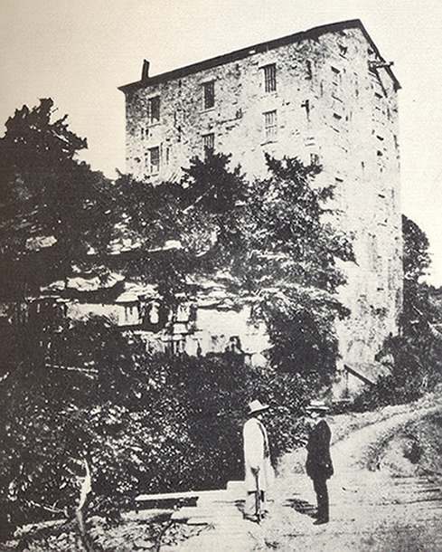
Photo: Photographer unknown, public domain · Wikimedia Commons
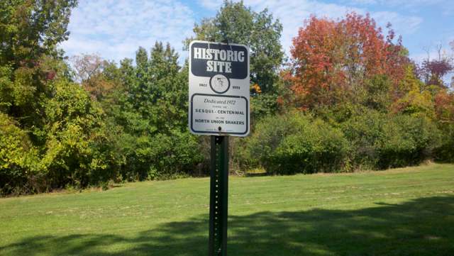
Photo: Annatha84 (Wikimedia Commons), CC BY-SA 3.0 · Wikimedia Commons
Local history sources: en.wikipedia.org · commons.wikimedia.org · commons.wikimedia.org · commons.wikimedia.org · clevelandhistorical.org · en.wikipedia.org
Historic places
4 places in Shaker Heights on the National Register of Historic Places. Press a pin or a name for its whole record.
-
Commodore Apartment BuildingBuilding · Shaker Heights · listed 1983
- Address
- 15610 Van Aken Blvd.
- Where
- Shaker Heights, Cuyahoga County · ZIP 44120
- What it is
- Building
- Listed on the National Register
- 1983
- NRIS reference number
- 83001951
- Coordinates
- 41.46648, -81.56865
National Register file (NPS) ↗ Search Wikipedia ↗ Street map and directions ↗ On the Cracked Buckeye map
-
Strong, Jacob, HouseBuilding · Shaker Heights
- Address
- 18829 Fairmount Blvd.
- Where
- Shaker Heights, Cuyahoga County · ZIP 44118
- What it is
- Building
- Latest NPS certification action
- 2023
- NRIS reference number
- 100009131
- Coordinates
- 41.48671, -81.54753
National Register file (NPS) ↗ Search Wikipedia ↗ Street map and directions ↗ On the Cracked Buckeye map
-
Tower EastBuilding · Shaker Heights · listed 2014
- Address
- 20600 Chagrin Blvd.
- Where
- Shaker Heights, Cuyahoga County · ZIP 44122
- What it is
- Building
- Listed on the National Register
- 2014
- NRIS reference number
- 14000029
- Coordinates
- 41.46187, -81.53405
National Register file (NPS) ↗ Search Wikipedia ↗ Street map and directions ↗ On the Cracked Buckeye map
-
Warren, Moses, HouseBuilding · Shaker Heights · listed 1974
- Address
- 3535 Ingleside Rd.
- Where
- Shaker Heights, Cuyahoga County · ZIP 44122
- What it is
- Building
- Listed on the National Register
- 1974
- NRIS reference number
- 74001462
- Coordinates
- 41.46330, -81.55509
National Register file (NPS) ↗ Search Wikipedia ↗ Street map and directions ↗ On the Cracked Buckeye map
Source: National Park Service, National Register of Historic Places point file. The listing year is shown where NPS's certification date agrees with the listing's reference number. Listing recognizes significance; it does not restrict a private owner.
Water
The Five Mile Crib, a small structure about 5 miles out in Lake Erie north of Cleveland's Edgewater Park The water here
- Cleveland Public Water System100% of residentsLake Erie
Hospitals, fire stations and more
Inside Shaker Heights's boundary: 2 dialysis centers, 1 nursing home, 2 fire and EMS stations, 1 high-hazard dam, 8 public schools, 4 private schools, 2 libraries, 4 museums, 1 police station, 11 public charging sites, 54 stations and terminals and 4 spill cases. Press a pin or a name for its whole record and its source.
Dialysis centers (2)
-
Center For Dialysis Care, ShakerDialysis · Shaker Heights
- Address
- 18720 Chagrin Blvd, Shaker Heights, OH 44122
- Dialysis stations
- 46
- Medicare star rating
- 1 of 5 stars
- Services
- in-center hemodialysis
- Shift starting after 5 pm
- Yes
- Ownership
- for profit
- Chain
- Centers for Dialysis Care
- Medicare certified since
- 1996-01-05
- Phone
- (216) 295-7000
- Medicare ID
- 362553
Medicare Care Compare ↗ CMS dialysis facility list (source) ↗ Street map and directions ↗
-
Fmc - Ohio Renal Care Group Home Dialysis ProgramDialysis · Cleveland
- Address
- 2429 Martin Luther King Jr. Drive, Cleveland, OH 44120
- Dialysis stations
- 5
- Medicare star rating
- 5 of 5 stars
- Services
- peritoneal dialysis, home hemodialysis training
- Ownership
- for profit
- Chain
- Fresenius Medical Care
- Medicare certified since
- 1989-11-10
- Phone
- (216) 421-1013
- Medicare ID
- 362570
Medicare Care Compare ↗ CMS dialysis facility list (source) ↗ Street map and directions ↗
Source: CMS dialysis facility list, September 2026, geocoded with the Census Bureau batch geocoder (an address it could not place sits at its ZIP center).
Nursing homes (1)
-
Shaker Gardens Nursing and Rehabilitation Center5 of 5 stars · Shaker Heights
- Address
- 3550 Northfield Road, Shaker Heights, OH 44122
- Certified beds
- 50
- Residents on an average day
- 45
- Medicare overall rating
- 5 of 5 stars
- Health inspections
- 4 of 5 stars
- Staffing
- 3 of 5 stars
- Quality measures
- 5 of 5 stars
- Penalties since 2023
- 4 fines totalling $18,306 (latest 2023-09-11)
- Ownership
- For profit - Corporation
- Chain
- LIONSTONE CARE
- Takes
- Medicare and Medicaid
- Phone
- (216) 752-5600
- Medicare ID
- 366021
Medicare Care Compare ↗ CMS nursing home data (source) ↗ Street map and directions ↗
Source: CMS Care Compare nursing home provider and penalties files; Medicare star ratings run 1 to 5.
Fire and EMS stations (2)
-
Shaker Heights Fire Department - Station 2Shaker Heights
- Address
- 2801 Warrensville Center Road, Shaker Heights, OH 44122
- Coordinates
- 41.47903, -81.53560
USGS National Map structures (source) ↗ Street map and directions ↗
-
Shaker Heights Fire Department Station 1Shaker Heights
- Address
- 17000 Chagrin Boulevard, Shaker Heights, OH 44120
- Coordinates
- 41.46421, -81.56119
USGS National Map structures (source) ↗ Street map and directions ↗
Source: USGS National Map structures (most Ohio records last updated 2019 to 2022), checked against the Columbus and Cleveland station lists. The department that answers a call is set by jurisdiction and mutual aid, not by distance.
High-hazard dams (1)
-
Upper Shaker Lake Dam UnsatisfactoryDoan Brook · condition: unsatisfactory
- Hazard class
- High: a failure would probably cost a life
- Condition
- Unsatisfactory (assessed 05/01/2023)
- River or stream
- Doan Brook
- Purpose
- Recreation
- Type
- Earth
- Height
- 30 ft
- Storage
- 155 acre-feet
- Completed
- 1852
- Owner type
- Local Government
- County
- Cuyahoga County
- Nearest town (NID)
- Cleveland Heights
- Last inspection
- 03/29/2023
- Emergency action plan
- Yes
- NID ID
- OH00353
National Inventory of Dams record ↗ National Inventory of Dams (source) ↗ Street map and directions ↗
Source: U.S. Army Corps of Engineers National Inventory of Dams, August 2026. "High hazard" rates what a failure would cost downstream, not how likely one is; the condition is the state's assessment.
Public schools (8)
-
Boulevard Elementary School4.5 of 5 stars · Shaker Heights
- Address
- 14900 Drexmore Rd, Shaker Heights, OH 44120
- School district
- Shaker Heights City School District
- Kind (NCES)
- Regular School
- Students, 2023-24
- 284
- Teachers (full-time equivalent)
- 19
- Report card, 2025-26
- 4.5 of 5 stars
- Performance index
- 84.8%
- Ohio building IRN
- 003244
- NCES school ID
- 390447501607
NCES school record ↗ Ohio School Report Card ↗ Street map and directions ↗
-
Fernway Elementary School4 of 5 stars · Shaker Heights
- Address
- 17420 Fernway Rd, Shaker Heights, OH 44120
- School district
- Shaker Heights City School District
- Kind (NCES)
- Regular School
- Students, 2023-24
- 290
- Teachers (full-time equivalent)
- 15
- Report card, 2025-26
- 4 of 5 stars
- Performance index
- 86.3%
- Ohio building IRN
- 011536
- NCES school ID
- 390447501609
NCES school record ↗ Ohio School Report Card ↗ Street map and directions ↗
-
Lomond Elementary School2.5 of 5 stars · Shaker Heights
- Address
- 17917 Lomond Blvd, Shaker Heights, OH 44122
- School district
- Shaker Heights City School District
- Kind (NCES)
- Regular School
- Students, 2023-24
- 372
- Teachers (full-time equivalent)
- 20
- Report card, 2025-26
- 2.5 of 5 stars
- Performance index
- 72.7%
- Ohio building IRN
- 021279
- NCES school ID
- 390447501610
NCES school record ↗ Ohio School Report Card ↗ Street map and directions ↗
-
Mercer Elementary School3.5 of 5 stars · Shaker Heights
- Address
- 23325 Wimbledon Rd, Shaker Heights, OH 44122
- School district
- Shaker Heights City School District
- Kind (NCES)
- Regular School
- Students, 2023-24
- 309
- Teachers (full-time equivalent)
- 22
- Report card, 2025-26
- 3.5 of 5 stars
- Performance index
- 75.6%
- Ohio building IRN
- 024307
- NCES school ID
- 390447501613
NCES school record ↗ Ohio School Report Card ↗ Street map and directions ↗
-
Onaway Elementary School4.5 of 5 stars · Shaker Heights
- Address
- 3115 Woodbury Rd, Shaker Heights, OH 44120
- School district
- Shaker Heights City School District
- Kind (NCES)
- Regular School
- Students, 2023-24
- 419
- Teachers (full-time equivalent)
- 23
- Report card, 2025-26
- 4.5 of 5 stars
- Performance index
- 85.7%
- Ohio building IRN
- 028647
- NCES school ID
- 390447501615
NCES school record ↗ Ohio School Report Card ↗ Street map and directions ↗
-
Shaker Hts High School4 of 5 stars · Shaker Heights
- Address
- 15911 Aldersyde Dr, Shaker Heights, OH 44120
- School district
- Shaker Heights City School District
- Kind (NCES)
- Regular School
- Students, 2023-24
- 1,474
- Teachers (full-time equivalent)
- 108.6
- Report card, 2025-26
- 4 of 5 stars
- Performance index
- 78.4%
- Four-year graduation rate
- 98%
- Ohio building IRN
- 034108
- NCES school ID
- 390447501616
NCES school record ↗ Ohio School Report Card ↗ Street map and directions ↗
-
Shaker Hts Middle School4 of 5 stars · Shaker Heights
- Address
- 20600 Shaker Blvd, Shaker Heights, OH 44122
- School district
- Shaker Heights City School District
- Kind (NCES)
- Regular School
- Students, 2023-24
- 644
- Teachers (full-time equivalent)
- 54
- Report card, 2025-26
- 4 of 5 stars
- Performance index
- 75.3%
- Ohio building IRN
- 004457
- NCES school ID
- 390447501608
NCES school record ↗ Ohio School Report Card ↗ Street map and directions ↗
-
Woodbury Elementary SchoolShaker Heights
- Address
- 15400 S Woodland Rd, Shaker Heights, OH 44120
- Kind (NCES)
- Regular School
- Students, 2023-24
- 642
- Teachers (full-time equivalent)
- 46.1
- NCES school ID
- 390447504323
Source: NCES EDGE public school locations 2024-25 and Common Core of Data 2023-24 (type, students, teachers); Ohio School Report Cards 2025-26 (Department of Education and Workforce), matched by name within the district.
Private schools (4)
-
Hathaway Brown SchoolPrivate, nonsectarian · Shaker Heights
- Address
- 19600 N Park Blvd, Shaker Heights, OH 44122
- Kind
- nonsectarian
- Students, 2023-24
- 665
- Teachers (full-time equivalent)
- 127.4
- Students per teacher
- 5.21978
- Phone
- (216) 932-4214
- NCES private school ID
- 01064052
-
Laurel SchoolPrivate, nonsectarian · Shaker Heights
- Address
- 1 Lyman Cir, Shaker Heights, OH 44122
- Kind
- nonsectarian
- Students, 2023-24
- 441
- Teachers (full-time equivalent)
- 60.6
- Students per teacher
- 7.27723
- Phone
- (216) 455-3002
- NCES private school ID
- A1790412
-
St Dominic SchoolPrivate, Catholic · Shaker Heights
- Address
- 3455 Norwood Rd, Shaker Heights, OH 44122
- Kind
- Catholic
- Students, 2023-24
- 204
- Teachers (full-time equivalent)
- 15.4
- Students per teacher
- 13.2468
- Phone
- (216) 561-4400
- NCES private school ID
- 01058887
-
The Reserve SchoolPrivate, nonsectarian, special program · Shaker Heights
- Address
- 22001 Fairmount Blvd, Bldg E, Shaker Heights, OH 44118
- Kind
- nonsectarian, special program
- Students, 2023-24
- 18
- Teachers (full-time equivalent)
- 3.4
- Students per teacher
- 5.29412
- Phone
- (216) 320-8972
- NCES private school ID
- A2302365
Source: NCES Private School Survey 2023-24.
Public libraries (2)
-
Bertram Woods BranchBranch · Shaker Heights
- Address
- 20600 Fayette Rd., Shaker Heights, OH 44122
- What it is
- Branch
- Library system
- Shaker Heights Public Library
- Open
- 2,600 hours a year, 52 weeks
- Building
- 11,903 sq ft
- System's visits, FY2024
- 274,768
- System's loans, FY2024
- 764,588
- People the system serves
- 33,188
- Phone
- (216) 991-2421
IMLS Public Libraries Survey (source) ↗ Street map and directions ↗
-
Shaker Heights Public LibraryCentral library · Shaker Heights
- Address
- 16500 Van Aken Boulevard, Shaker Heights, OH 44120
- What it is
- Central library
- Library system
- Shaker Heights Public Library
- Open
- 3,588 hours a year, 52 weeks
- Building
- 65,179 sq ft
- System's visits, FY2024
- 274,768
- System's loans, FY2024
- 764,588
- People the system serves
- 33,188
- Phone
- (216) 991-2030
IMLS Public Libraries Survey (source) ↗ Street map and directions ↗
Source: IMLS Public Libraries Survey FY2024 (outlets and their systems). Any Ohio resident can get a free card at any Ohio public library.
Museums, historical societies, gardens and zoos (4)
-
Cleveland CarouselHistorical society · Shaker Heights
- What it is
- Historical society
- City
- Shaker Heights
- Coordinates
- 41.47265, -81.53876
Search Wikipedia ↗ IMLS Museum Data Files (source) ↗ Street map and directions ↗
The museum list is IMLS's 2018 file; a museum may have closed or moved since.
-
Nature Center At Shaker LakesArboretum or botanical garden · Cleveland
- What it is
- Arboretum or botanical garden
- City
- Cleveland
- Coordinates
- 41.48352, -81.57224
Search Wikipedia ↗ IMLS Museum Data Files (source) ↗ Street map and directions ↗
The museum list is IMLS's 2018 file; a museum may have closed or moved since.
-
Negro League Baseball Legends Hall Of FameMuseum · Shaker Heights
- What it is
- Museum
- City
- Shaker Heights
- Coordinates
- 41.46571, -81.54011
Search Wikipedia ↗ IMLS Museum Data Files (source) ↗ Street map and directions ↗
The museum list is IMLS's 2018 file; a museum may have closed or moved since.
-
Shaker Historical MuseumHistorical society · Shaker Heights
- What it is
- Historical society
- City
- Shaker Heights
- Coordinates
- 41.48180, -81.56248
Search Wikipedia ↗ IMLS Museum Data Files (source) ↗ Street map and directions ↗
The museum list is IMLS's 2018 file; a museum may have closed or moved since.
Source: IMLS Museum Data Files, 2018.
Police stations (1)
-
Shaker Heights Police DepartmentShaker Heights
- Address
- 3355 Lee Road, Shaker Heights, OH 44120
- Coordinates
- 41.46814, -81.56455
USGS National Map structures (source) ↗ Street map and directions ↗
Source: USGS National Map structures, police stations, corrected and completed by hand (September 2026). The department that answers a call is set by jurisdiction, not by distance.
Public EV charging (11)
-
City Hall Annex2 Level 2 · Shaker Heights
- Address
- 3358 Lee Rd, Shaker Heights, OH 44120
- Ports
- 2 Level 2
- Plugs
- J1772
- Network
- AMPUP
- Hours
- Contact station for hours of availability.
- Phone
- 833-692-6787
Station Locator (NREL) ↗ Alternative Fuels Data Center (source) ↗ Street map and directions ↗
-
First Unitarian Church - Cleveland2 Level 2 · Shaker Heights
- Address
- 21600 Shaker Blvd, Shaker Heights, OH 44122
- Ports
- 2 Level 2
- Plugs
- J1772
- Network
- Non-Networked
- Hours
- 24 hours daily
- Price
- Free
- Phone
- 216-751-2320
Station Locator (NREL) ↗ Alternative Fuels Data Center (source) ↗ Street map and directions ↗
-
Green Road Station2 Level 2 · Shaker Height
- Address
- 2800 South Green Road, Shaker Height, OH 44122
- Ports
- 2 Level 2
- Plugs
- J1772
- Network
- FLO
- Hours
- 24 hours daily
- Phone
- 888-356-8911
Station Locator (NREL) ↗ Alternative Fuels Data Center (source) ↗ Street map and directions ↗
-
Larchmere Public Parking2 Level 2 · Cleveland
- Address
- 13051 Larchmere Blvd, Cleveland, OH 44120
- Ports
- 2 Level 2
- Plugs
- J1772
- Network
- AMPUP
- Hours
- Contact station for hours of availability.
- Phone
- 833-692-6787
Station Locator (NREL) ↗ Alternative Fuels Data Center (source) ↗ Street map and directions ↗
-
Shaker Heights City Hall2 Level 2 · Shaker Heights
- Address
- 3380 Lee Rd, Shaker Heights, OH 44120
- Ports
- 2 Level 2
- Plugs
- J1772
- Network
- AMPUP
- Hours
- 24 hours daily
- Phone
- 833-692-6787
Station Locator (NREL) ↗ Alternative Fuels Data Center (source) ↗ Street map and directions ↗
-
Shaker Heights Plaza - Tesla Supercharger DC fast12 DC fast · Shaker Heights
- Address
- 20040-20200 Van Aken Blvd, Shaker Heights, OH 44122
- Ports
- 12 DC fast
- Plugs
- Tesla (NACS)
- Network
- Tesla
- Hours
- 24 hours daily. Please check Tesla's online station map to see if an adapter is required at this location.
- Phone
- 877-798-3752
Station Locator (NREL) ↗ Alternative Fuels Data Center (source) ↗ Street map and directions ↗
-
The Dealership1 Level 2 · Shaker Heights
- Address
- 3558 Lee Rd, Shaker Heights, OH 44120
- Ports
- 1 Level 2
- Plugs
- J1772
- Network
- AMPUP
- Hours
- 24 hours daily
- Price
- Free
- Phone
- 216-455-5499
Station Locator (NREL) ↗ Alternative Fuels Data Center (source) ↗ Street map and directions ↗
-
The Van Aken District Parking Garage2 Level 2 · Shaker Heights
- Address
- 3401 Tuttle Rd, Shaker Heights, OH 44122
- Ports
- 2 Level 2
- Plugs
- J1772
- Network
- AMPUP
- Hours
- 24 hours daily
- Phone
- 833-692-6787
Station Locator (NREL) ↗ Alternative Fuels Data Center (source) ↗ Street map and directions ↗
-
Thornton Park2 Level 2 · Shaker Heights
- Address
- 3301 Warrensville Center Rd, Shaker Heights, OH 44122
- Ports
- 2 Level 2
- Plugs
- J1772
- Network
- AMPUP
- Hours
- 24 hours daily
- Price
- $0.20 per kWh; Minimum payment of $0.50
- Phone
- 833-692-6787
Station Locator (NREL) ↗ Alternative Fuels Data Center (source) ↗ Street map and directions ↗
-
VAN AKEN DIST EV 12 Level 2 · Shaker Heights
- Address
- 3401 tuttle rd, Shaker Heights, OH 44122
- Ports
- 2 Level 2
- Plugs
- J1772, Tesla (NACS)
- Network
- ChargePoint Network
- Hours
- 24 hours daily
- Phone
- 888-758-4389
Station Locator (NREL) ↗ Alternative Fuels Data Center (source) ↗ Street map and directions ↗
-
Van Aken District Garage2 Level 2 · Shaker Heights
- Address
- 20305 Van Aken Blvd, Shaker Heights, OH 44122
- Ports
- 2 Level 2
- Plugs
- J1772
- Network
- AMPUP
- Hours
- Contact station for hours of availability.
- Phone
- 833-692-6787
Station Locator (NREL) ↗ Alternative Fuels Data Center (source) ↗ Street map and directions ↗
Source: NREL Alternative Fuels Data Center station list (May 2026), public and open stations, the posts at one address counted as one site.
Stations and terminals (54)
-
AshbyTransit center or station · Shaker Heights
- What it is
- Transit center or station
- City
- Shaker Heights
- Coordinates
- 41.46840, -81.57240
BTS Intermodal Passenger Connectivity Database (source) ↗ Street map and directions ↗
-
Ashby StationRail transit stop · Greater Cleveland RTA
- What it is
- Rail transit stop
- Operator
- Greater Cleveland RTA
- Coordinates
- 41.46859, -81.57273
BTS National Transit Map (source) ↗ Street map and directions ↗
-
Ashby StationRail transit stop · Greater Cleveland RTA
- What it is
- Rail transit stop
- Operator
- Greater Cleveland RTA
- Coordinates
- 41.46843, -81.57247
BTS National Transit Map (source) ↗ Street map and directions ↗
-
AttleboroTransit center or station · Shaker Heights
- What it is
- Transit center or station
- City
- Shaker Heights
- Coordinates
- 41.47880, -81.55840
BTS Intermodal Passenger Connectivity Database (source) ↗ Street map and directions ↗
-
Attleboro StationRail transit stop · Greater Cleveland RTA
- What it is
- Rail transit stop
- Operator
- Greater Cleveland RTA
- Coordinates
- 41.47897, -81.55870
BTS National Transit Map (source) ↗ Street map and directions ↗
-
Attleboro StationRail transit stop · Greater Cleveland RTA
- What it is
- Rail transit stop
- Operator
- Greater Cleveland RTA
- Coordinates
- 41.47882, -81.55815
BTS National Transit Map (source) ↗ Street map and directions ↗
-
AvalonTransit center or station · Shaker Heights
- What it is
- Transit center or station
- City
- Shaker Heights
- Coordinates
- 41.46640, -81.55810
BTS Intermodal Passenger Connectivity Database (source) ↗ Street map and directions ↗
-
Avalon StationRail transit stop · Greater Cleveland RTA
- What it is
- Rail transit stop
- Operator
- Greater Cleveland RTA
- Coordinates
- 41.46656, -81.55937
BTS National Transit Map (source) ↗ Street map and directions ↗
-
BelvoirTransit center or station · Shaker Heights
- What it is
- Transit center or station
- City
- Shaker Heights
- Coordinates
- 41.47920, -81.52750
BTS Intermodal Passenger Connectivity Database (source) ↗ Street map and directions ↗
-
Belvoir StationRail transit stop · Greater Cleveland RTA
- What it is
- Rail transit stop
- Operator
- Greater Cleveland RTA
- Coordinates
- 41.47851, -81.52728
BTS National Transit Map (source) ↗ Street map and directions ↗
-
CourtlandTransit center or station · Shaker Heights
- What it is
- Transit center or station
- City
- Shaker Heights
- Coordinates
- 41.47840, -81.54330
BTS Intermodal Passenger Connectivity Database (source) ↗ Street map and directions ↗
-
Courtland StationRail transit stop · Greater Cleveland RTA
- What it is
- Rail transit stop
- Operator
- Greater Cleveland RTA
- Coordinates
- 41.47852, -81.54283
BTS National Transit Map (source) ↗ Street map and directions ↗
-
CoventryTransit center or station · Shaker Heights
- What it is
- Transit center or station
- City
- Shaker Heights
- Coordinates
- 41.48310, -81.58410
BTS Intermodal Passenger Connectivity Database (source) ↗ Street map and directions ↗
-
Coventry StationRail transit stop · Greater Cleveland RTA
- What it is
- Rail transit stop
- Operator
- Greater Cleveland RTA
- Coordinates
- 41.48334, -81.58469
BTS National Transit Map (source) ↗ Street map and directions ↗
-
Coventry StationRail transit stop · Greater Cleveland RTA
- What it is
- Rail transit stop
- Operator
- Greater Cleveland RTA
- Coordinates
- 41.48323, -81.58427
BTS National Transit Map (source) ↗ Street map and directions ↗
-
EatonTransit center or station · Shaker Heights
- What it is
- Transit center or station
- City
- Shaker Heights
- Coordinates
- 41.47860, -81.55000
BTS Intermodal Passenger Connectivity Database (source) ↗ Street map and directions ↗
-
Eaton StationRail transit stop · Greater Cleveland RTA
- What it is
- Rail transit stop
- Operator
- Greater Cleveland RTA
- Coordinates
- 41.47847, -81.55006
BTS National Transit Map (source) ↗ Street map and directions ↗
-
FarnsleighTransit center or station · Shaker Heights
- What it is
- Transit center or station
- City
- Shaker Heights
- Coordinates
- 41.46640, -81.53990
BTS Intermodal Passenger Connectivity Database (source) ↗ Street map and directions ↗
-
Farnsleigh StationRail transit stop · Greater Cleveland RTA
- What it is
- Rail transit stop
- Operator
- Greater Cleveland RTA
- Coordinates
- 41.46663, -81.53980
BTS National Transit Map (source) ↗ Street map and directions ↗
-
Farnsleigh StationRail transit stop · Greater Cleveland RTA
- What it is
- Rail transit stop
- Operator
- Greater Cleveland RTA
- Coordinates
- 41.46654, -81.53931
BTS National Transit Map (source) ↗ Street map and directions ↗
-
GreenTransit center or station · Shaker Heights
- What it is
- Transit center or station
- City
- Shaker Heights
- Coordinates
- 41.47790, -81.51700
BTS Intermodal Passenger Connectivity Database (source) ↗ Street map and directions ↗
-
Green Rd StationRail transit stop · Greater Cleveland RTA
- What it is
- Rail transit stop
- Operator
- Greater Cleveland RTA
- Coordinates
- 41.47853, -81.51819
BTS National Transit Map (source) ↗ Street map and directions ↗
-
Green Rd StationRail transit stop · Greater Cleveland RTA
- What it is
- Rail transit stop
- Operator
- Greater Cleveland RTA
- Coordinates
- 41.47858, -81.51819
BTS National Transit Map (source) ↗ Street map and directions ↗
-
Green Rd Station (Bus)Rail transit stop · Greater Cleveland RTA
- What it is
- Rail transit stop
- Operator
- Greater Cleveland RTA
- Coordinates
- 41.47880, -81.51838
BTS National Transit Map (source) ↗ Street map and directions ↗
-
KenmoreTransit center or station · Shaker Heights
- What it is
- Transit center or station
- City
- Shaker Heights
- Coordinates
- 41.46640, -81.55160
BTS Intermodal Passenger Connectivity Database (source) ↗ Street map and directions ↗
-
Kenmore StationRail transit stop · Greater Cleveland RTA
- What it is
- Rail transit stop
- Operator
- Greater Cleveland RTA
- Coordinates
- 41.46661, -81.55309
BTS National Transit Map (source) ↗ Street map and directions ↗
-
Lee - GreenTransit center or station · Shaker Heights
- What it is
- Transit center or station
- City
- Shaker Heights
- Coordinates
- 41.48070, -81.56510
BTS Intermodal Passenger Connectivity Database (source) ↗ Street map and directions ↗
-
Lee -BlueTransit center or station · Cleveland
- What it is
- Transit center or station
- City
- Cleveland
- Coordinates
- 41.46640, -81.56500
BTS Intermodal Passenger Connectivity Database (source) ↗ Street map and directions ↗
-
LynnfieldTransit center or station · Shaker Heights
- What it is
- Transit center or station
- City
- Shaker Heights
- Coordinates
- 41.46640, -81.54660
BTS Intermodal Passenger Connectivity Database (source) ↗ Street map and directions ↗
-
Lynnfield StationRail transit stop · Greater Cleveland RTA
- What it is
- Rail transit stop
- Operator
- Greater Cleveland RTA
- Coordinates
- 41.46657, -81.54590
BTS National Transit Map (source) ↗ Street map and directions ↗
-
OnawayTransit center or station · Shaker Heights
- What it is
- Transit center or station
- City
- Shaker Heights
- Coordinates
- 41.47180, -81.57640
BTS Intermodal Passenger Connectivity Database (source) ↗ Street map and directions ↗
-
Onaway StationRail transit stop · Greater Cleveland RTA
- What it is
- Rail transit stop
- Operator
- Greater Cleveland RTA
- Coordinates
- 41.47223, -81.57693
BTS National Transit Map (source) ↗ Street map and directions ↗
-
Onaway StationRail transit stop · Greater Cleveland RTA
- What it is
- Rail transit stop
- Operator
- Greater Cleveland RTA
- Coordinates
- 41.47189, -81.57646
BTS National Transit Map (source) ↗ Street map and directions ↗
-
S Woodland StationRail transit stop · Greater Cleveland RTA
- What it is
- Rail transit stop
- Operator
- Greater Cleveland RTA
- Coordinates
- 41.47889, -81.58451
BTS National Transit Map (source) ↗ Street map and directions ↗
-
Shaker & Lee StationRail transit stop · Greater Cleveland RTA
- What it is
- Rail transit stop
- Operator
- Greater Cleveland RTA
- Coordinates
- 41.48096, -81.56582
BTS National Transit Map (source) ↗ Street map and directions ↗
-
Shaker & Lee StationRail transit stop · Greater Cleveland RTA
- What it is
- Rail transit stop
- Operator
- Greater Cleveland RTA
- Coordinates
- 41.48072, -81.56428
BTS National Transit Map (source) ↗ Street map and directions ↗
-
Shaker & Southington StationRail transit stop · Greater Cleveland RTA
- What it is
- Rail transit stop
- Operator
- Greater Cleveland RTA
- Coordinates
- 41.48240, -81.57731
BTS National Transit Map (source) ↗ Street map and directions ↗
-
Shaker & Warrensville StationRail transit stop · Greater Cleveland RTA
- What it is
- Rail transit stop
- Operator
- Greater Cleveland RTA
- Coordinates
- 41.47848, -81.53677
BTS National Transit Map (source) ↗ Street map and directions ↗
-
South ParkTransit center or station · Shaker Heights
- What it is
- Transit center or station
- City
- Shaker Heights
- Coordinates
- 41.48160, -81.57180
BTS Intermodal Passenger Connectivity Database (source) ↗ Street map and directions ↗
-
South Park StationRail transit stop · Greater Cleveland RTA
- What it is
- Rail transit stop
- Operator
- Greater Cleveland RTA
- Coordinates
- 41.48169, -81.57195
BTS National Transit Map (source) ↗ Street map and directions ↗
-
South WoodlandTransit center or station · Cleveland
- What it is
- Transit center or station
- City
- Cleveland
- Coordinates
- 41.47890, -81.58440
BTS Intermodal Passenger Connectivity Database (source) ↗ Street map and directions ↗
-
Southington - GreenTransit center or station · Shaker Heights
- What it is
- Transit center or station
- City
- Shaker Heights
- Coordinates
- 41.48230, -81.57750
BTS Intermodal Passenger Connectivity Database (source) ↗ Street map and directions ↗
-
Southington -BlueTransit center or station · Shaker Heights
- What it is
- Transit center or station
- City
- Shaker Heights
- Coordinates
- 41.47550, -81.58060
BTS Intermodal Passenger Connectivity Database (source) ↗ Street map and directions ↗
-
Van Aken & Lee StationRail transit stop · Greater Cleveland RTA
- What it is
- Rail transit stop
- Operator
- Greater Cleveland RTA
- Coordinates
- 41.46656, -81.56543
BTS National Transit Map (source) ↗ Street map and directions ↗
-
Van Aken & Southington StationRail transit stop · Greater Cleveland RTA
- What it is
- Rail transit stop
- Operator
- Greater Cleveland RTA
- Coordinates
- 41.47581, -81.58105
BTS National Transit Map (source) ↗ Street map and directions ↗
-
Van Aken & Southington StationRail transit stop · Greater Cleveland RTA
- What it is
- Rail transit stop
- Operator
- Greater Cleveland RTA
- Coordinates
- 41.47555, -81.58067
BTS National Transit Map (source) ↗ Street map and directions ↗
-
Van Aken & Warrensville StnRail transit stop · Greater Cleveland RTA
- What it is
- Rail transit stop
- Operator
- Greater Cleveland RTA
- Coordinates
- 41.46593, -81.53803
BTS National Transit Map (source) ↗ Street map and directions ↗
-
Van Aken & Warrensville StnRail transit stop · Greater Cleveland RTA
- What it is
- Rail transit stop
- Operator
- Greater Cleveland RTA
- Coordinates
- 41.46597, -81.53799
BTS National Transit Map (source) ↗ Street map and directions ↗
-
Van Aken-Warrnsvle Stn(Bus)Rail transit stop · Greater Cleveland RTA
- What it is
- Rail transit stop
- Operator
- Greater Cleveland RTA
- Coordinates
- 41.46566, -81.53802
BTS National Transit Map (source) ↗ Street map and directions ↗
-
W Green Rd StationRail transit stop · Greater Cleveland RTA
- What it is
- Rail transit stop
- Operator
- Greater Cleveland RTA
- Coordinates
- 41.47852, -81.52052
BTS National Transit Map (source) ↗ Street map and directions ↗
-
W Green Rd StationRail transit stop · Greater Cleveland RTA
- What it is
- Rail transit stop
- Operator
- Greater Cleveland RTA
- Coordinates
- 41.47857, -81.52052
BTS National Transit Map (source) ↗ Street map and directions ↗
-
Warrensville - GreenTransit center or station · Shaker Heights
- What it is
- Transit center or station
- City
- Shaker Heights
- Coordinates
- 41.47940, -81.53630
BTS Intermodal Passenger Connectivity Database (source) ↗ Street map and directions ↗
-
Warrensville -BlueTransit center or station · Shaker Heights
- What it is
- Transit center or station
- City
- Shaker Heights
- Coordinates
- 41.46480, -81.53630
BTS Intermodal Passenger Connectivity Database (source) ↗ Street map and directions ↗
-
West GreenTransit center or station · Shaker Heights
- What it is
- Transit center or station
- City
- Shaker Heights
- Coordinates
- 41.47860, -81.51780
BTS Intermodal Passenger Connectivity Database (source) ↗ Street map and directions ↗
Source: BTS Intermodal Passenger Connectivity Database and National Transit Map (2025). Bus stops are counted on the card and drawn on the full map.
Spills reported since 2021 (4)
-
Oil Petroleum Not Otherwise Specified (Nos) Reached water2023-01-27 · Shaker Heights
- Reported
- 2023-01-27
- What spilled
- Oil Petroleum Not Otherwise Specified (Nos)
- Reached a waterway
- Doan Brook
- Where
- Shaker Heights, Cuyahoga County
- Ohio EPA district office
- NEDO
- Ohio EPA case number
- 2301EPA0000133
Ohio EPA spill reports (source) ↗ Street map and directions ↗
-
Fuel Diesel / Diesel Fuel (Vehicle On Or Off Road)2022-11-28 · Shaker Heights
- Reported
- 2022-11-28
- What spilled
- Fuel Diesel / Diesel Fuel (Vehicle On Or Off Road)
- Largest amount reported
- 50 gallons
- Where
- Shaker Heights, Cuyahoga County
- Ohio EPA district office
- NEDO
- Ohio EPA case number
- 2211EPA0001764
Ohio EPA spill reports (source) ↗ Street map and directions ↗
-
Fuel Diesel / Diesel Fuel (Vehicle On Or Off Road)2021-04-30 · Shaker Heights
- Reported
- 2021-04-30
- What spilled
- Fuel Diesel / Diesel Fuel (Vehicle On Or Off Road)
- Where
- Shaker Heights, Cuyahoga County
- Ohio EPA district office
- NEDO
- Ohio EPA case number
- 2104EPA0000594
Ohio EPA spill reports (source) ↗ Street map and directions ↗
-
Sheen Rainbow / Hydrocarbon Reached water2021-03-22 · Shaker Heights
- Reported
- 2021-03-22
- What spilled
- Sheen Rainbow / Hydrocarbon
- Reached a waterway
- 18 - Doan Brook
- Where
- Shaker Heights, Cuyahoga County
- Ohio EPA district office
- NEDO
- Ohio EPA case number
- 2103EPA0000377
Ohio EPA spill reports (source) ↗ Street map and directions ↗
Source: Ohio EPA emergency response spill reports, 2021 to September 2026, one point per case where Ohio EPA placed it. A report is what the caller or responder recorded; amounts are often blank or estimated.
Its ZIP codes
Each ZIP code that touches Shaker Heights, with the share of its residents who live here and the same headline figures as the ZIP page.
Local government
Who holds office in Shaker Heights, how its elections and ballot issues came out, and the state auditor's record.
Auditor of State record
- No fiscal caution, watch or emergency on the Auditor of State's lists.
- Financial Health Indicators (the Auditor of State's 17 measures; critical / cautionary / positive): 2020 0 / 2 / 15; 2021 0 / 0 / 17; 2022 0 / 0 / 17; 2023 0 / 2 / 15; 2024 0 / 0 / 17; 2025 0 / 1 / 15.
- Agreed Upon Procedures, 2024, released 2025-08-28
- Agreed Upon Procedures, 2023, released 2024-07-30
The county
Cuyahoga County: 52 ZIP codes, 59 cities, villages and townships, 1,270,867 people.
Nearby places
Rain and snow
How much has actually fallen on Shaker Heights, day by day, from 1871 to now. Daily totals, not averages.
- rain, last 30 days
- 1.94 in
- 2026-09-29 to 2026-10-28
- rain so far in 2026
- 33.6 in
- 1.8 in below normal for the date
- snow so far in 2026
- 52.6 in
- a normal year brings 66.4 in
- a normal year
- 42.2 in
- average of 25 years, 1991-2020
| Month | Rain (in) | Snow (in) | Days counted |
|---|---|---|---|
| October 2026 | 1.94 | — | 28 |
| September 2026 | 2.60 | — | 30 |
| August 2026 | 7.73 | — | 31 |
| July 2026 | 2.06 | — | 31 |
| June 2026 | 2.63 | — | 30 |
| May 2026 | 3.67 | — | 31 |
| April 2026 | 5.96 | 0.0 | 30 |
| March 2026 | 3.42 | 3.4 | 31 |
| February 2026 | 0.81 | 8.9 | 28 |
| January 2026 | 2.75 | 40.3 | 31 |
| December 2025 | 3.19 | 18.5 | 31 |
| November 2025 | 2.87 | 11.4 | 30 |
| Wettest year | 2011 — 63.8 in |
|---|---|
| Driest year | 1963 — 20.9 in |
| Snowiest year | 1996 — 121.3 in |
| Wettest day on record | 11 August 2017 — 3.73 in |
| Heaviest snowfall in a day | 10 November 1996 — 14.02 in |
| Deepest snow on the ground | 14 November 1996 — 32.99 in |
Mostly estimated. Only 10% of these days come from a gauge standing inside Shaker Heights - the rest are worked out from the nearest gauges around it, so read them as close estimates rather than readings.
50,505 days of records, 1871-01-01 to 2026-10-28. Source: NOAA NCEI GHCN-Daily, 3,240 gauges in and around Ohio. A day is "gauged" when a gauge standing inside the boundary reported it, and the value is the mean of those gauges. Otherwise it is interpolated by inverse distance from every gauge reporting within 50 miles. Nothing is carried forward, back-filled or smoothed. Against NOAA nClimDiv county monthly precipitation over 136,848 complete county-months (checked 2026-10-31): correlation 0.9515, median absolute difference 0.217 in a month. Built 2026-10-31 from the Cracked Buckeye precipitation archive. Snow is the softer number — snowfall is measured by hand with a ruler, no agency publishes a gridded county snowfall series, and blowing snow defeats every observer.
Environmental permits and filings
What Ohio EPA has on file for Shaker Heights: permits, inspections, violations, cleanups and the state loans behind sewer and water work. Every line links to the agency's own document.
- facilities and sites on file
- 23
- those placed on the map inside Shaker Heights
| Program | Facilities and sites |
|---|---|
| Wastewater and stormwater discharge | 10 |
| Air pollution | 5 |
| Wetland and stream fill | 3 |
| Hazardous waste | 2 |
| Medical waste | 1 |
| Municipal Solid Waste Transfer Facilities | 1 |
| Scrap tires | 1 |
| Date | Facility or site | What |
|---|---|---|
| SHAKER HEIGHTS TRANSFER FACILITY | Municipal Solid Waste Transfer Facilities inspection | |
| WINSLOW/AVALON SEWER REPLACEMENT PHASE 1 & 2 | Wastewater and stormwater discharge permit | |
| CUY - LEE ROAD (CR-8) | Wastewater and stormwater discharge permit | |
| DOAN BROOK RESTORATION AT HORSESHOE PARK (1629) | Wetland and stream fill permit | |
| CUY - LEE ROAD (CR-8) | Wastewater and stormwater discharge permit | |
| DOAN BROOK RESTORATION AT HORSESHOE PARK (1629) | Wetland and stream fill permit | |
| SHAKER HEIGHTS TRANSFER FACILITY | Municipal Solid Waste Transfer Facilities permit | |
| DOAN BROOK RESTORATION AT HORSESHOE PARK (1629) | Wetland and stream fill permit | |
| SHAKER JUST RITE CLEANERS INC | Air pollution report | |
| SAINT DOMINIC'S SCHOOL | Air pollution report | |
| DOAN BROOK RESTORATION AT HORSESHOE PARK (1629) | Wetland and stream fill permit | |
| SHAKER HEIGHTS TRANSFER FACILITY | Municipal Solid Waste Transfer Facilities permit | |
| SHAKER JUST RITE CLEANERS INC | Air pollution permit | |
| CELLULAR TECHNOLOGY LIMITED | Medical waste registration | |
| DOAN BROOK RESTORATION AT HORSESHOE PARK (1629) | Wetland and stream fill permit | |
| SHAKER HEIGHTS TRANSFER FACILITY | Municipal Solid Waste Transfer Facilities report | |
| CUY - LEE ROAD (CR-8) | Wastewater and stormwater discharge permit | |
| DOAN BROOK RESTORATION AT HORSESHOE PARK (1629) | Wastewater and stormwater discharge permit | |
| SHAKER HEIGHTS SCHOOLS - WOODBURY MIDDLE YEARS | Wastewater and stormwater discharge permit | |
| SHAKER HEIGHTS SCHOOLS - WOODBURY MIDDLE | Wastewater and stormwater discharge permit | |
| PIR 3844 LOMOND AND AVALON | Wastewater and stormwater discharge permit | |
| PIR 3936 - SCOTTSDALE AND AVALON | Wastewater and stormwater discharge permit | |
| SHAKER NATURE CENTER EROSION CONTROL & WETLAND | Wetland and stream fill permit | |
| SHAKER NATURE CENTER EROSION CONTROL & WETLAND | Wetland and stream fill permit | |
| SHAKER HEIGHTS TRANSFER FACILITY | Municipal Solid Waste Transfer Facilities inspection |
Source: Ohio EPA eDocument portal (edocpub.epa.ohio.gov), indexed 2026-10-14. Facilities are placed on the map from Ohio EPA's own map layers, EPA's Facility Registry, coordinates written in the filings, or a geocoded street address. A permit filed under a private person's name (most are household septic systems) is counted but never named, placed or linked; licenses for individual workers and open-burning notices are left out entirely.
Quick answers
What county is Shaker Heights, Ohio in?
Shaker Heights is a city in Cuyahoga County, Ohio, with 29,426 residents.
When was Shaker Heights, Ohio founded?
Shaker Heights was settled 1822 (North Union Shaker community); laid out 1905-1912 (Van Sweringen brothers' planned suburb); incorporated 1912 (Shaker Village); 1931 (city). Founders on record: North Union Shakers (Ralph Russell, founder); Oris Paxton and Mantis James Van Sweringen (suburb developers). Source
How did Shaker Heights, Ohio get its name?
Shaker Heights takes its name from the North Union Shaker religious community that settled and farmed the land from 1822 to 1889, combined with 'Heights' for the elevated plateau east of Cleveland where the Van Sweringen brothers built their planned suburb starting in 1905. Source
What ZIP code is Shaker Heights, Ohio?
Shaker Heights is served by ZIP codes 44122, 44120 and 44118; 44122 holds the largest share of its residents.
Where does Shaker Heights, Ohio get its water?
The main water source for Shaker Heights (Cleveland Public Water System): The Five Mile Crib, a small structure about 5 miles out in Lake Erie north of Cleveland's Edgewater Park.
Cite this page
Cite this page as:
Cracked Buckeye, "Shaker Heights, Cuyahoga County", https://crackedbuckeye.com/place/shaker-heights/, built 2026-10-31, accessed [date].
How to cite · Report a correction · Built 2026-10-31
