Mayfield Heights
City · Cuyahoga County · 20,500 residents · 1.5% municipal income tax
Local events in Mayfield Heights
14 events in the next 90 days from 3 public calendars. All local events in Mayfield Heights
Checked October 20; the events page is refreshed daily.
How Mayfield Heights began
Mayfield Heights takes its name from the older Mayfield Township, founded in 1819, from which it separated as its own community in 1920, incorporating as a village in 1925 and a city in 1951. The suburb drew significant Italian American settlement as families moved east from Cleveland's Little Italy neighborhood, and after the Soviet Union's 1991 collapse it also became home to a substantial community of immigrants from Russia and other former Soviet republics. Its population grew from 2,612 in 1930 to a peak of 22,139 in 1970 before settling around 20,000; the city's one National Register listing, the 1886 W.A. Thorp House on Mayfield Road, was demolished in 1990 for a bank branch but remains listed despite no longer existing.
Settled 1819 (Mayfield Township), incorporated 1920 (separated from Mayfield Township); 1925 (village); 1951 (city).
Where the name comes from
Mayfield Heights takes its name from Mayfield Township, founded in 1819, from which it separated in 1920; no source we reviewed explains the origin of 'Mayfield' itself.
Before the town
No source we reviewed names a specific Native American village, trail or burial site within present Mayfield Heights. The area lies within the Connecticut Western Reserve, secured for settlement by the 1785 Treaty of Fort McIntosh and the 1795 Treaty of Greenville.
Timeline
- — Mayfield Township is founded.
- — The W.A. Thorp House is built on Mayfield Road, designed by Thorp himself.
- — Mayfield Heights is founded, separating from Mayfield Township.
- — Mayfield Heights incorporates as a village.
- — Mayfield Heights' population is 2,612.
- — Mayfield Heights incorporates as a city.
- — Mayfield Heights' population peaks at 22,139.
- — The W.A. Thorp House is added to the National Register of Historic Places.
- — The W.A. Thorp House is demolished and replaced with a U.S. Bank branch at 6189 Mayfield Road; the property remains on the National Register despite the original building's loss.
- — Following the Soviet Union's collapse, Mayfield Heights becomes home to a significant number of immigrants from Russia and other former Soviet republics.
Stories
A landmark that outlived its own building
W.A. Thorp built his house on Mayfield Road in 1886, and it stood long enough, and was distinctive enough, to be added to the National Register of Historic Places on December 4, 1978. That designation did not save it: by 1990 the house had been torn down and replaced with a U.S. Bank branch, an ordinary brick bank building that today occupies the exact site. The National Register listing was never formally withdrawn, so the Thorp House address in Mayfield Heights carries, on paper, federal historic recognition for a building that anyone driving past today would find only as a bank -- one of the clearer local reminders that a National Register listing protects a building's name in the record, not the building itself.
From Little Italy to the Soviet diaspora
Mayfield Heights' population history traces two distinct waves of immigration into a single, relatively small suburb. Italian American families were among its earliest and most defining settlers, moving east out of Cleveland's crowded Little Italy neighborhood as the community grew from 2,612 residents in 1930 toward its 1970 peak of 22,139. Two decades later, the collapse of the Soviet Union in 1991 opened a very different migration: a substantial number of families from Russia and other former Soviet republics settled in Mayfield Heights and neighboring suburbs, adding a second, largely Russian-speaking community to a city whose civic and cultural life had for decades been shaped mainly by its Italian American population.
Photographs
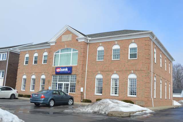
Photo: Nyttend (Wikimedia Commons), public domain · Wikimedia Commons
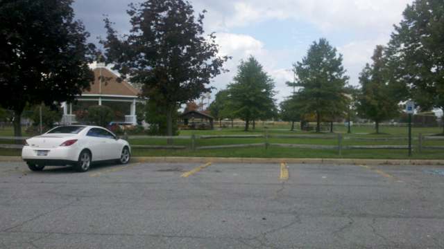
Photo: mil199 (Wikimedia Commons, via Panoramio), CC BY 3.0 · Wikimedia Commons
Local history sources: en.wikipedia.org · en.wikipedia.org · commons.wikimedia.org · commons.wikimedia.org
Historic places
1 place in Mayfield Heights on the National Register of Historic Places. Press a pin or a name for its whole record.
-
Thorp, W. A., HouseBuilding · Mayfield Heights · listed 1978
- Address
- 6183--6185 Mayfield Rd.
- Where
- Mayfield Heights, Cuyahoga County · ZIP 44124
- What it is
- Building
- Listed on the National Register
- 1978
- NRIS reference number
- 78002046
- Coordinates
- 41.52039, -81.45634
National Register file (NPS) ↗ Search Wikipedia ↗ Street map and directions ↗ On the Cracked Buckeye map
Source: National Park Service, National Register of Historic Places point file. The listing year is shown where NPS's certification date agrees with the listing's reference number. Listing recognizes significance; it does not restrict a private owner.
Water
The Five Mile Crib, a small structure about 5 miles out in Lake Erie north of Cleveland's Edgewater Park The water here
- Cleveland Public Water System100% of residentsLake Erie
Hospitals, fire stations and more
Inside Mayfield Heights's boundary: 1 hospital, 2 nursing homes, 1 fire or EMS station, 1 college, 2 public schools, 1 police station, 2 public charging sites, 2 Superfund sites, 2 Toxics Release Inventory facilities and 3 spill cases. Press a pin or a name for its whole record and its source.
Hospitals (1)
-
Hillcrest Hospital Trauma level IIGeneral hospital · Mayfield Hts
- What it is
- General hospital
- Address
- 6780 Mayfield Road, Mayfield Hts, OH 44124
- County
- Cuyahoga County
- Beds
- 532
- Trauma center
- Level II
- Helipad
- Yes
- Ownership
- Non-profit
- Medicare overall rating
- 5 of 5 stars
- Emergency department (Medicare)
- No
- Phone
- (440) 312-4415
- Medicare ID
- 360230
Medicare Care Compare ↗ Where HIFLD got this record ↗ HIFLD hospitals (source) ↗ Street map and directions ↗
Source: HIFLD hospitals inventory via FEMA (closed hospitals it still lists left out, hospitals opened since added), with Medicare Care Compare ratings matched by name and address.
Nursing homes (2)
-
Ahc of Landerhaven Llc4 of 5 stars · Mayfield Heights
- Address
- 2108 Lander Road, Mayfield Heights, OH 44124
- Certified beds
- 46
- Residents on an average day
- 41
- Medicare overall rating
- 4 of 5 stars
- Health inspections
- 4 of 5 stars
- Staffing
- 4 of 5 stars
- Quality measures
- 4 of 5 stars
- Penalties since 2023
- none
- Ownership
- For profit - Limited Liability company
- Chain
- ADVANCED HEALTH CARE
- Takes
- Medicare and Medicaid
- Phone
- (440) 443-0345
- Medicare ID
- 366458
Medicare Care Compare ↗ CMS nursing home data (source) ↗ Street map and directions ↗
-
Gardens of Mayfield Village Special focus2 of 5 stars · Mayfield Heights
- Address
- 6757 Mayfield Rd, Mayfield Heights, OH 44124
- Certified beds
- 99
- Residents on an average day
- 58
- Medicare overall rating
- 2 of 5 stars
- Health inspections
- 1 of 5 stars
- Staffing
- 1 of 5 stars
- Quality measures
- 5 of 5 stars
- Penalties since 2023
- 2 fines totalling $155,225, 2 payment denials (latest 2025-05-29)
- Special focus facility
- SFF Candidate
- Ownership
- For profit - Corporation
- Takes
- Medicare and Medicaid
- Phone
- (440) 473-0090
- Medicare ID
- 365355
Medicare Care Compare ↗ CMS nursing home data (source) ↗ Street map and directions ↗
Source: CMS Care Compare nursing home provider and penalties files; Medicare star ratings run 1 to 5.
Fire and EMS stations (1)
-
Mayfield Heights Fire DepartmentMayfield Heights
- Address
- 6154 Mayfield Road, Mayfield Heights, OH 44124
- Coordinates
- 41.51967, -81.45784
USGS National Map structures (source) ↗ Street map and directions ↗
Source: USGS National Map structures (most Ohio records last updated 2019 to 2022), checked against the Columbus and Cleveland station lists. The department that answers a call is set by jurisdiction and mutual aid, not by distance.
Colleges (1)
-
LaBarberia Institute of HairFor-profit two-year college · Mayfield Hts
- What it is
- For-profit two-year college
- City
- Mayfield Hts
- Students, 2023-24 (12-month count)
- 335
- Graduation rate
- 60% within three years (a class of 97)
- IPEDS unit ID
- 483920
College Navigator (NCES) ↗ IPEDS data (source) ↗ Street map and directions ↗
Source: NCES IPEDS 2024 directory, 2023-24 enrollment and tuition, graduation rates for the 2017 (four-year) and 2020 (two-year) entering classes.
Public schools (2)
-
Lander Elementary3.5 of 5 stars · Cleveland
- Address
- 1714 Lander Rd, Cleveland, OH 44124
- School district
- Mayfield City School District
- Kind (NCES)
- Regular School
- Students, 2023-24
- 485
- Teachers (full-time equivalent)
- 27
- Report card, 2025-26
- 3.5 of 5 stars
- Performance index
- 81.1%
- Ohio building IRN
- 019778
- NCES school ID
- 390443701296
NCES school record ↗ Ohio School Report Card ↗ Street map and directions ↗
-
Mayfield Middle School4.5 of 5 stars · Cleveland
- Address
- 1123 Som Center Rd, Cleveland, OH 44124
- School district
- Mayfield City School District
- Kind (NCES)
- Regular School
- Students, 2023-24
- 900
- Teachers (full-time equivalent)
- 53
- Report card, 2025-26
- 4.5 of 5 stars
- Performance index
- 83.2%
- Ohio building IRN
- 062349
- NCES school ID
- 390443704451
NCES school record ↗ Ohio School Report Card ↗ Street map and directions ↗
Source: NCES EDGE public school locations 2024-25 and Common Core of Data 2023-24 (type, students, teachers); Ohio School Report Cards 2025-26 (Department of Education and Workforce), matched by name within the district.
Police stations (1)
-
Mayfield Heights Police DepartmentMayfield Heights
- Address
- 6154 Mayfield Road, Mayfield Heights, OH 44124
- Coordinates
- 41.52001, -81.45766
Where this record comes from ↗ USGS National Map structures (source) ↗ Street map and directions ↗
Source: USGS National Map structures, police stations, corrected and completed by hand (September 2026). The department that answers a call is set by jurisdiction, not by distance.
Public EV charging (2)
-
Eastgate Shopping Center DC fast4 DC fast · Mayfield Heights
- Address
- 1371 Som Center Rd, Mayfield Heights, OH 44124
- Ports
- 4 DC fast
- Plugs
- CCS, CHAdeMO
- Network
- eVgo Network
- Hours
- 24 hours daily
- Phone
- 877-455-3833
Station Locator (NREL) ↗ Alternative Fuels Data Center (source) ↗ Street map and directions ↗
-
Nick Mayer Ford2 Level 2 · Mayfield Heights
- Address
- 6200 Mayfield Rd, Mayfield Heights, OH 44124
- Ports
- 2 Level 2
- Plugs
- J1772
- Network
- Non-Networked
- Hours
- 24 hours daily
- Price
- Free
- Phone
- 440-449-1000
Station Locator (NREL) ↗ Alternative Fuels Data Center (source) ↗ Street map and directions ↗
Source: NREL Alternative Fuels Data Center station list (May 2026), public and open stations, the posts at one address counted as one site.
Superfund sites (2)
-
6000 Block Mayfield RdSuperfund program · Mayfield Heights
- Address
- 6051 Mayfield Rd (On & Around), Mayfield Heights, OH 44124
- County
- Cuyahoga County
- Status
- Superfund program site, not on the National Priorities List
- EPA program ID
- OHN000510930
- EPA registry ID
- 110067350752
EPA facility record ↗ EPA Facility Registry Service (source) ↗ Street map and directions ↗
-
Mallard Drive Mercury SpillSuperfund program · Mayfield Heights
- Address
- 1628 Mallard Drive, Mayfield Heights, OH 44124
- County
- Cuyahoga County
- Status
- Superfund program site, not on the National Priorities List
- EPA program ID
- OHN000508217
- EPA registry ID
- 110009304840
EPA facility record ↗ EPA Facility Registry Service (source) ↗ Street map and directions ↗
Source: EPA Facility Registry Service, Superfund (SEMS) and National Priorities List sites. Many program sites were assessed and needed no cleanup.
Facilities reporting toxic releases (2)
-
Beck AluminumToxics Release Inventory · Mayfield Heights
- Address
- 300 Allen Bradley Dr, Mayfield Heights, OH 44124
- County
- Cuyahoga County
- Status
- Reports to the Toxics Release Inventory
- EPA program ID
- TRI_OFFSITE_227
- EPA registry ID
- 110028097208
EPA facility record ↗ EPA Facility Registry Service (source) ↗ Street map and directions ↗
-
Ettkin Scrap Metal & Iron CoToxics Release Inventory · Cleveland
- Address
- 161 Stonecreek Dr, Cleveland, OH 44143
- County
- Cuyahoga County
- Status
- Reports to the Toxics Release Inventory
- EPA program ID
- TRI_OFFSITE_737
- EPA registry ID
- 110070690406
EPA facility record ↗ EPA Facility Registry Service (source) ↗ Street map and directions ↗
Source: EPA Facility Registry Service, Toxics Release Inventory reporters. Reporting a release is required of large users of listed chemicals; it is not by itself a violation.
Spills reported since 2021 (3)
-
Fuel Jet / Kerosene (All)2022-08-30 · Cleveland
- Reported
- 2022-08-30
- What spilled
- Fuel Jet / Kerosene (All)
- Where
- Cleveland, Cuyahoga County
- Ohio EPA district office
- NEDO
- Ohio EPA case number
- 2208EPA0001336
Ohio EPA spill reports (source) ↗ Street map and directions ↗
-
Material White Reached water2021-07-23 · Mayfield Heights
- Reported
- 2021-07-23
- What spilled
- Material White
- Reached a waterway
- 99 - Unnamed
- Where
- Mayfield Heights, Cuyahoga County
- Ohio EPA district office
- NEDO
- Ohio EPA case number
- 2107EPA0001113
Ohio EPA spill reports (source) ↗ Street map and directions ↗
-
Material Unknown2026-05-24 · Mayfield Heights
- Reported
- 2026-05-24
- What spilled
- Material Unknown
- Where
- Mayfield Heights, Cuyahoga County
- Ohio EPA district office
- NEDO
- Ohio EPA case number
- 2605EPA0000887
Ohio EPA spill reports (source) ↗ Street map and directions ↗
Source: Ohio EPA emergency response spill reports, 2021 to September 2026, one point per case where Ohio EPA placed it. A report is what the caller or responder recorded; amounts are often blank or estimated.
Its ZIP codes
Each ZIP code that touches Mayfield Heights, with the share of its residents who live here and the same headline figures as the ZIP page.
| ZIP | Share | Water | Radon | Home value | Schools | Flood |
|---|---|---|---|---|---|---|
| 44124 Mayfield Heights and Cleveland | 48% | The Five Mile Crib, a small structure about 5 miles out in Lake Erie north of Cleveland's Edgewater Park | 2.0 pCi/L average radon | Median year built 1956 | Mayfield City · 5 stars overall | 0.6% of residents in the 1% floodplain |
| 44040 Gates Mills | 5% | The Five Mile Crib, a small structure about 5 miles out in Lake Erie north of Cleveland's Edgewater Park | 3.1 pCi/L average radon | Median year built 1963 | Mayfield City · 5 stars overall | 2.2% of residents in the 1% floodplain |
| 44143 Richmond Heights and Cleveland | 3% | Lake Erie, through a 10-foot tunnel running nearly 4 miles offshore from northeast Cleveland's lakefront | 2.8 pCi/L average radon | Median year built 1969 | Mayfield City · 5 stars overall | 1.0% of residents in the 1% floodplain |
Local government
Who holds office in Mayfield Heights, how its elections and ballot issues came out, and the state auditor's record.
Auditor of State record
- No fiscal caution, watch or emergency on the Auditor of State's lists.
- Financial Health Indicators (the Auditor of State's 17 measures; critical / cautionary / positive): 2019 0 / 3 / 14; 2020 0 / 3 / 14; 2021 0 / 1 / 16; 2022 1 / 4 / 12; 2023 3 / 2 / 12; 2024 2 / 1 / 14.
- Financial Audit, 2025, released 2026-09-15
- OPERS Examination, 2025, released 2026-05-12
- Financial Audit, 2024, released 2025-10-21
- Compliance Examination, 2024, released 2025-08-05
- Financial Audit, 2023, released 2024-08-13
The county
Cuyahoga County: 52 ZIP codes, 59 cities, villages and townships, 1,270,867 people.
Nearby places
Rain and snow
How much has actually fallen on Mayfield Heights, day by day, from 1871 to now. Daily totals, not averages.
- rain, last 30 days
- 1.83 in
- 2026-10-01 to 2026-10-30
- rain so far in 2026
- 34.6 in
- 3.6 in below normal for the date
- snow so far in 2026
- 46.9 in
- a normal year brings 81.8 in
- a normal year
- 45.8 in
- average of 30 years, 1991-2020
| Month | Rain (in) | Snow (in) | Days counted |
|---|---|---|---|
| October 2026 | 1.82 | — | 30 |
| September 2026 | 3.09 | — | 30 |
| August 2026 | 7.68 | — | 31 |
| July 2026 | 2.55 | — | 31 |
| June 2026 | 2.66 | — | 30 |
| May 2026 | 4.05 | — | 31 |
| April 2026 | 6.31 | 0.1 | 30 |
| March 2026 | 3.48 | 2.0 | 31 |
| February 2026 | 0.63 | 9.1 | 28 |
| January 2026 | 2.29 | 35.8 | 31 |
| December 2025 | 2.93 | 16.5 | 31 |
| November 2025 | 2.23 | 11.2 | 30 |
| Wettest year | 2011 — 69.7 in |
|---|---|
| Driest year | 1963 — 23.4 in |
| Snowiest year | 1969 — 143.7 in |
| Wettest day on record | 28 July 2006 — 4.26 in |
| Heaviest snowfall in a day | 9 March 2008 — 15.98 in |
| Deepest snow on the ground | 14 November 1996 — 37.86 in |
Estimated, not measured. No rain gauge has ever stood inside Mayfield Heights, so every figure here is worked out from the gauges around it - the nearest ones weighted most. Treat them as close estimates rather than readings.
56,914 days of records, 1871-01-01 to 2026-10-30. Source: NOAA NCEI GHCN-Daily, 3,240 gauges in and around Ohio. A day is "gauged" when a gauge standing inside the boundary reported it, and the value is the mean of those gauges. Otherwise it is interpolated by inverse distance from every gauge reporting within 50 miles. Nothing is carried forward, back-filled or smoothed. Against NOAA nClimDiv county monthly precipitation over 136,848 complete county-months (checked 2026-11-01): correlation 0.9515, median absolute difference 0.217 in a month. Built 2026-11-01 from the Cracked Buckeye precipitation archive. Snow is the softer number — snowfall is measured by hand with a ruler, no agency publishes a gridded county snowfall series, and blowing snow defeats every observer.
Environmental permits and filings
What Ohio EPA has on file for Mayfield Heights: permits, inspections, violations, cleanups and the state loans behind sewer and water work. Every line links to the agency's own document.
- facilities and sites on file
- 13
- those placed on the map inside Mayfield Heights
| Program | Facilities and sites |
|---|---|
| Air pollution | 6 |
| Hazardous waste | 3 |
| Wastewater and stormwater discharge | 3 |
| Sewer and water-line construction | 1 |
| Date | Facility or site | What |
|---|---|---|
| CITY OF MAYFIELD HEIGHTS | Wastewater and stormwater discharge permit | |
| SPROUTS | Wastewater and stormwater discharge permit | |
| COSTCO GASOLINE LOCATION NO 344 | Air pollution permit | |
| CITY OF MAYFIELD HEIGHTS | Sewer and water-line construction permit | |
| CITY OF MAYFIELD HEIGHTS | Sewer and water-line construction permit | |
| PROGRESSIVE - OMEGA NORTH BUILDING | Wastewater and stormwater discharge permit | |
| HILLCREST HOSPITAL CCHS | Air pollution permit | |
| CIRCLE K #5701 | Hazardous waste compliance letter | |
| PENGUIN DRY CLEANERS INC | Air pollution permit | |
| COSTCO WHOLESALE #344 | Air pollution permit | |
| COSTCO WHOLESALE #344 | Air pollution permit | |
| RITE AID #7939 | Hazardous waste compliance letter | |
| COSTCO WHOLESALE #344 | Hazardous waste report | |
| COSTCO WHOLESALE #344 | Hazardous waste compliance letter |
Source: Ohio EPA eDocument portal (edocpub.epa.ohio.gov), indexed 2026-10-14. Facilities are placed on the map from Ohio EPA's own map layers, EPA's Facility Registry, coordinates written in the filings, or a geocoded street address. A permit filed under a private person's name (most are household septic systems) is counted but never named, placed or linked; licenses for individual workers and open-burning notices are left out entirely.
Quick answers
What county is Mayfield Heights, Ohio in?
Mayfield Heights is a city in Cuyahoga County, Ohio, with 20,500 residents.
When was Mayfield Heights, Ohio founded?
Mayfield Heights was settled 1819 (Mayfield Township); incorporated 1920 (separated from Mayfield Township); 1925 (village); 1951 (city). Source
How did Mayfield Heights, Ohio get its name?
Mayfield Heights takes its name from Mayfield Township, founded in 1819, from which it separated in 1920; no source we reviewed explains the origin of 'Mayfield' itself. Source
What ZIP code is Mayfield Heights, Ohio?
Mayfield Heights is served by ZIP codes 44124, 44040 and 44143; 44124 holds the largest share of its residents.
Where does Mayfield Heights, Ohio get its water?
The main water source for Mayfield Heights (Cleveland Public Water System): The Five Mile Crib, a small structure about 5 miles out in Lake Erie north of Cleveland's Edgewater Park.
Cite this page
Cite this page as:
Cracked Buckeye, "Mayfield Heights, Cuyahoga County", https://crackedbuckeye.com/place/mayfield-heights/, built 2026-10-31, accessed [date].
How to cite · Report a correction · Built 2026-10-31