Local events in East Cleveland
25 events in the next 90 days from 1 public calendar. All local events in East Cleveland
Checked October 20; the events page is refreshed daily.
Deep dives about East Cleveland
Long reads built from maps, newspapers and public records. All deep dives
Notable people from East Cleveland
Ohioans tied to this place, each with a sourced profile. All notable Ohioans
History from East Cleveland
People and inventions tied to this place, each with its sources. All people · All inventions
How East Cleveland began
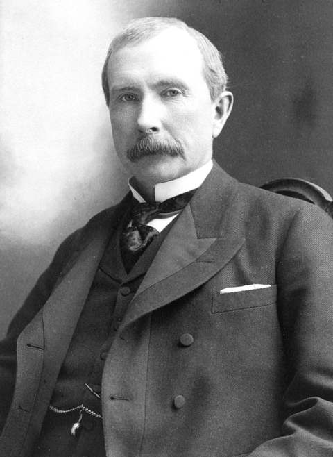
East Cleveland grew up partly through Scottish immigrant families -- the Shaw, McIlrath and Eddy names still visible locally -- and incorporated as a village in 1895, becoming a city in 1911 with a charter progressive enough to include women's suffrage provisions, unusual anywhere east of the Mississippi at the time. Its stretch of Euclid Avenue was part of Cleveland's Gilded Age 'Millionaires' Row,' and John D. Rockefeller's Forest Hill estate stood partly within the city; the National Electric Lamp Association, absorbed into General Electric in 1911, built Nela Park here beginning that year, the world's first industrial park, where physicist Albert Einstein visited in 1922. Demographic change accelerated from the 1960s, and by 1984 East Cleveland was one of Ohio's largest majority-Black communities; declining revenue pushed the city into a state-declared fiscal emergency in 1988 over water and sewer fund deficits exceeding $2 million, a financial strain that has recurred in the decades since. East Cleveland's population is about 13,800 today.
Incorporated 1895 (village); 1911 (city), by Scottish immigrant families among the early settlers (Shaw, McIlrath, Eddy).
Where the name comes from
No source we reviewed explains the specific naming of East Cleveland beyond its straightforward geographic position east of Cleveland.
Before the town
No source we reviewed names a specific Native American village, trail or burial site within present East Cleveland. The area lies within the Connecticut Western Reserve, secured for settlement by the 1785 Treaty of Fort McIntosh and the 1795 Treaty of Greenville.
Timeline
- — The First United Presbyterian Church of East Cleveland (also called First Church of Christ in Euclid) is built on Euclid Avenue, designed by architect William Warren Sabin in Richardsonian Romanesque style.
- — East Cleveland incorporates as a village.
- — The National Electric Lamp Association is formed by John Robert Crouse Sr., J.B. Crouse and H.A. Tremaine.
- — East Cleveland becomes a city with a charter including women's suffrage provisions; the same year, the National Electric Lamp Association dissolves into General Electric and construction begins on Nela Park, the world's first industrial park, designed by architect Frank E. Wallis.
- — Physicist Albert Einstein visits Nela Park and the Case School of Applied Science in Cleveland, where he meets Professor Dayton Miller, a critic of the Michelson-Morley experiment.
- — GE's Lighting & Electrical Institute is founded at Nela Park.
- — Nela Park is listed on the National Register of Historic Places.
- — The First Church of Christ in Euclid (First United Presbyterian Church of East Cleveland) is listed on the National Register of Historic Places.
- — East Cleveland is counted among the largest primarily Black communities in Ohio.
- — East Cleveland enters state-declared fiscal emergency over water and sewer fund deficits exceeding $2 million.
Stories
Einstein's stop at the world's first industrial park
Nela Park began in 1911 as the National Electric Lamp Association dissolved into General Electric, and architect Frank E. Wallis laid out a 92-acre campus in East Cleveland designed to look and feel like a university rather than a factory complex -- Georgian Revival buildings, lawns and courtyards housing lightbulb research and manufacturing instead of lecture halls, a template widely credited as the world's first true industrial park. It drew serious scientific visitors: in 1922, Albert Einstein toured Nela Park alongside physicist Ernest Fox Nichols as part of a Cleveland trip that also took him to the Case School of Applied Science, where he met Professor Dayton Miller, a physicist known for his skeptical experiments challenging the Michelson-Morley result underlying Einstein's own theory of relativity. Nela Park kept expanding its research mission through the 1930s, founding GE's Lighting & Electrical Institute in 1933, and was listed on the National Register of Historic Places in 1975 -- an industrial campus significant enough, sixty years after Einstein's visit, to be recognized as a landmark for how it was built as much as for what it made.
A charter ahead of its time, a city later in crisis
When East Cleveland incorporated as a city in 1911, its new charter included provisions for women's suffrage nearly a decade before the Nineteenth Amendment -- a stance Wikipedia's own account of the city calls 'unheard of east of the Mississippi River' at the time, and a marker of how the city saw itself in its Millionaires' Row era, when Euclid Avenue mansions and a share of John D. Rockefeller's Forest Hill estate gave it some of Cleveland's most prominent real estate. That early reputation did not protect the city from the demographic and economic pressures that reshaped so many older, inner-ring Cleveland suburbs in the second half of the 20th century: by 1984 East Cleveland had become one of Ohio's largest majority-Black communities, and a shrinking tax base pushed the city into a state-declared fiscal emergency in 1988 over water and sewer fund deficits topping $2 million -- a financial strain that, unlike the 1911 charter's confident optimism, has recurred for East Cleveland in the decades since.
Photographs
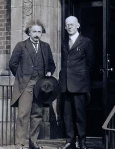
Photo: General Electric (Dartmouth Archives), public domain · Wikimedia Commons
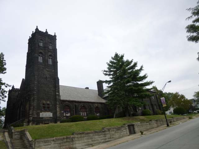
Photo: Ponceesponce (Wikimedia Commons), Wiki Loves Monuments 2013, CC BY-SA 3.0 · Wikimedia Commons
Local history sources: en.wikipedia.org · en.wikipedia.org · en.wikipedia.org · commons.wikimedia.org · commons.wikimedia.org
Historic places
3 places in East Cleveland on the National Register of Historic Places. Press a pin or a name for its whole record.
-
First Church of Christ in EuclidBuilding · East Cleveland · listed 1978
- Address
- 16200 Euclid Ave.
- Where
- East Cleveland, Cuyahoga County · ZIP 44112
- What it is
- Building
- Listed on the National Register
- 1978
- NRIS reference number
- 78002044
- Coordinates
- 41.54458, -81.56670
National Register file (NPS) ↗ Search Wikipedia ↗ Street map and directions ↗ On the Cracked Buckeye map
-
Garfield Terrace ApartmentsBuilding · East Cleveland
- Address
- 13344 Euclid Ave.
- Where
- East Cleveland, Cuyahoga County · ZIP 44112
- What it is
- Building
- Latest NPS certification action
- 2021
- NRIS reference number
- 100007225
- Coordinates
- 41.52202, -81.59002
National Register file (NPS) ↗ Search Wikipedia ↗ Street map and directions ↗ On the Cracked Buckeye map
-
St. Paul's Episcopal Church of East ClevelandBuilding · East Cleveland · listed 1984
- Address
- 15837 Euclid Ave.
- Where
- East Cleveland, Cuyahoga County · ZIP 44112
- What it is
- Building
- Listed on the National Register
- 1984
- NRIS reference number
- 84000130
- Coordinates
- 41.54195, -81.57027
National Register file (NPS) ↗ Search Wikipedia ↗ Street map and directions ↗ On the Cracked Buckeye map
Source: National Park Service, National Register of Historic Places point file. The listing year is shown where NPS's certification date agrees with the listing's reference number. Listing recognizes significance; it does not restrict a private owner.
Water
Lake Erie, through a 10-foot tunnel running nearly 4 miles offshore from northeast Cleveland's lakefront The water here
- Cleveland Public Water System100% of residentsLake Erie
Hospitals, fire stations and more
Inside East Cleveland's boundary: 1 health center, 2 nursing homes, 2 fire and EMS stations, 1 power plant, 1 high-hazard dam, 6 public schools, 1 library, 1 police station, 2 Toxics Release Inventory facilities, 5 stations and terminals and 13 spill cases. Press a pin or a name for its whole record and its source.
Community health centers (1)
-
EAST CLEVELAND HEALTH CENTERHealth center · Cleveland
- Run by
- a federally qualified health center
- Setting
- Clinic
- City
- Cleveland
- Coordinates
- 41.53691, -81.57580
Find a Health Center (HRSA) ↗ HRSA data (source) ↗ Street map and directions ↗
Source: HRSA health center service delivery sites, active, September 2026 (school-based sites left out). Health centers see patients whether or not they have insurance, with fees on a sliding scale.
Nursing homes (2)
-
Candlewood Healthcare and Rehabilitation3 of 5 stars · East Cleveland
- Address
- 1835 Belmore Ave, East Cleveland, OH 44112
- Certified beds
- 116
- Residents on an average day
- 90
- Medicare overall rating
- 3 of 5 stars
- Health inspections
- 3 of 5 stars
- Staffing
- 1 of 5 stars
- Quality measures
- 5 of 5 stars
- Penalties since 2023
- 1 fine totalling $29,488 (latest 2024-10-01)
- Ownership
- For profit - Limited Liability company
- Chain
- CERTUS HEALTHCARE
- Takes
- Medicare and Medicaid
- Phone
- (216) 268-3600
- Medicare ID
- 365353
Medicare Care Compare ↗ CMS nursing home data (source) ↗ Street map and directions ↗
-
Gardens of Mcgregor and Amasa Stone5 of 5 stars · East Cleveland
- Address
- 14900 Private Dr, East Cleveland, OH 44112
- Certified beds
- 148
- Residents on an average day
- 137
- Medicare overall rating
- 5 of 5 stars
- Health inspections
- 4 of 5 stars
- Staffing
- 2 of 5 stars
- Quality measures
- 5 of 5 stars
- Penalties since 2023
- none
- Ownership
- Non profit - Other
- Takes
- Medicare and Medicaid
- Phone
- (216) 851-8200
- Medicare ID
- 366350
- Map point
- the ZIP's center (the address did not geocode)
Medicare Care Compare ↗ CMS nursing home data (source) ↗ Street map and directions ↗
Source: CMS Care Compare nursing home provider and penalties files; Medicare star ratings run 1 to 5.
Fire and EMS stations (2)
-
East Cleveland Fire DepartmentCleveland
- Address
- 1822 Marloes Avenue, Cleveland, OH 44112
- Coordinates
- 41.52994, -81.58170
USGS National Map structures (source) ↗ Street map and directions ↗
-
East Cleveland Fire Department Station 2Cleveland
- Address
- 14301 Shaw Avenue, Cleveland, OH 44112
- Coordinates
- 41.53965, -81.58234
USGS National Map structures (source) ↗ Street map and directions ↗
Source: USGS National Map structures (most Ohio records last updated 2019 to 2022), checked against the Columbus and Cleveland station lists. The department that answers a call is set by jurisdiction and mutual aid, not by distance.
Power plants (1)
-
MCCo Solar Generating FacilitySolar · 1 MW
- Capacity
- 1 MW
- Main source
- Solar
- Technology
- Solar Photovoltaic
- Operator
- The Medical Center Company
- Sector
- IPP Non-CHP
- Where
- Cleveland, Cuyahoga County
- Generating units
- 1
- Built
- 2014
- EIA plant code
- 59324
EIA plant page ↗ EIA-860 (source) ↗ Street map and directions ↗
Source: EIA-860 power plant inventory via HIFLD (February 2025), with plant codes, units and years from EIA-860 2025.
High-hazard dams (1)
-
Forest Hill Park Dam No. 2 PoorEast Branch of Dugway Brook · condition: poor
- Hazard class
- High: a failure would probably cost a life
- Condition
- Poor (assessed 01/12/2024)
- River or stream
- East Branch of Dugway Brook
- Purpose
- Flood Risk Reduction
- Type
- Earth
- Height
- 37 ft
- Storage
- 137 acre-feet
- Completed
- 1963
- Owner type
- Local Government
- County
- Cuyahoga County
- Nearest town (NID)
- East Cleveland
- Last inspection
- 04/26/2023
- Emergency action plan
- No
- NID ID
- OH00918
National Inventory of Dams record ↗ National Inventory of Dams (source) ↗ Street map and directions ↗
Source: U.S. Army Corps of Engineers National Inventory of Dams, August 2026. "High hazard" rates what a failure would cost downstream, not how likely one is; the condition is the state's assessment.
Public schools (6)
-
Apex AcademyCleveland
- Address
- 16005 Terrace Rd, Cleveland, OH 44112
- Kind (NCES)
- Regular School
- Students, 2023-24
- 472
- Teachers (full-time equivalent)
- 25.5
- NCES school ID
- 390030904846
-
Mayfair Elementary School2.5 of 5 stars · East Cleveland
- Address
- 13916 Mayfair Ave, East Cleveland, OH 44112
- School district
- East Cleveland City School District
- Kind (NCES)
- Regular School
- Students, 2023-24
- 146
- Teachers (full-time equivalent)
- 12
- Report card, 2025-26
- 2.5 of 5 stars
- Performance index
- 50.6%
- Ohio building IRN
- 032912
- NCES school ID
- 390439000865
NCES school record ↗ Ohio School Report Card ↗ Street map and directions ↗
-
Prospect AcademyEast Cleveland
- Address
- 1843 Stanwood Rd, East Cleveland, OH 44112
- Kind (NCES)
- Regular School
- Students, 2023-24
- 73
- Teachers (full-time equivalent)
- 8
- NCES school ID
- 390439000867
-
Shaw High School3 of 5 stars · East Cleveland
- Address
- 15320 Euclid Ave, East Cleveland, OH 44112
- School district
- East Cleveland City School District
- Kind (NCES)
- Regular School
- Students, 2023-24
- 441
- Teachers (full-time equivalent)
- 42
- Report card, 2025-26
- 3 of 5 stars
- Performance index
- 52.5%
- Four-year graduation rate
- 87%
- Ohio building IRN
- 034199
- NCES school ID
- 390439000866
NCES school record ↗ Ohio School Report Card ↗ Street map and directions ↗
-
Superior School for the Performing Arts3 of 5 stars · East Cleveland
- Address
- 1865 Garfield Rd, East Cleveland, OH 44112
- School district
- East Cleveland City School District
- Kind (NCES)
- Regular School
- Students, 2023-24
- 69
- Teachers (full-time equivalent)
- 9
- Report card, 2025-26
- 3 of 5 stars
- Performance index
- 60.5%
- Ohio building IRN
- 020109
- NCES school ID
- 390439010858
NCES school record ↗ Ohio School Report Card ↗ Street map and directions ↗
-
W.H. Kirk Middle School3 of 5 stars · East Cleveland
- Address
- 14410 Terrace Rd, East Cleveland, OH 44112
- School district
- East Cleveland City School District
- Kind (NCES)
- Regular School
- Students, 2023-24
- 242
- Teachers (full-time equivalent)
- 20
- Report card, 2025-26
- 3 of 5 stars
- Performance index
- 41.5%
- Ohio building IRN
- 038679
- NCES school ID
- 390439000868
NCES school record ↗ Ohio School Report Card ↗ Street map and directions ↗
Source: NCES EDGE public school locations 2024-25 and Common Core of Data 2023-24 (type, students, teachers); Ohio School Report Cards 2025-26 (Department of Education and Workforce), matched by name within the district.
Public libraries (1)
-
East Cleveland Public LibraryCentral library · East Cleveland
- Address
- 14101 Euclid Ave., East Cleveland, OH 44112
- What it is
- Central library
- Library system
- East Cleveland Public Library
- Open
- 2,756 hours a year, 52 weeks
- Building
- 35,367 sq ft
- System's visits, FY2024
- 63,128
- System's loans, FY2024
- 31,330
- People the system serves
- 16,884
- Phone
- (216) 541-4128
IMLS Public Libraries Survey (source) ↗ Street map and directions ↗
Source: IMLS Public Libraries Survey FY2024 (outlets and their systems). Any Ohio resident can get a free card at any Ohio public library.
Police stations (1)
-
East Cleveland Police DepartmentEast Cleveland
- Address
- 14340 Euclid Avenue, East Cleveland, OH 44112
- Coordinates
- 41.53011, -81.58196
USGS National Map structures (source) ↗ Street map and directions ↗
Source: USGS National Map structures, police stations, corrected and completed by hand (September 2026). The department that answers a call is set by jurisdiction, not by distance.
Facilities reporting toxic releases (2)
-
Electrolizing Corporation of Ohio Plant 1Toxics Release Inventory · Cleveland
- Address
- 1325 East 152Nd Street, Cleveland, OH 44112
- County
- Cuyahoga County
- Status
- Reports to the Toxics Release Inventory (active)
- EPA program ID
- 44112LCTRL1325E
- EPA registry ID
- 110000893310
EPA facility record ↗ EPA Facility Registry Service (source) ↗ Street map and directions ↗
-
Electrolizing Corporation of Ohio Plant 2Toxics Release Inventory · Cleveland
- Address
- 1655 Collamer Rd, Cleveland, OH 44110
- County
- Cuyahoga County
- Status
- Reports to the Toxics Release Inventory (active)
- EPA program ID
- 44112LCTRL1655C
- EPA registry ID
- 110000387028
EPA facility record ↗ EPA Facility Registry Service (source) ↗ Street map and directions ↗
Source: EPA Facility Registry Service, Toxics Release Inventory reporters. Reporting a release is required of large users of listed chemicals; it is not by itself a violation.
Stations and terminals (5)
-
Louis Stokes Station at WindermereTransit center or station · Cleveland
- What it is
- Transit center or station
- City
- Cleveland
- Coordinates
- 41.52940, -81.58320
BTS Intermodal Passenger Connectivity Database (source) ↗ Street map and directions ↗
-
Stokes-Windermere StationRail transit stop · Greater Cleveland RTA
- What it is
- Rail transit stop
- Operator
- Greater Cleveland RTA
- Coordinates
- 41.53038, -81.58499
BTS National Transit Map (source) ↗ Street map and directions ↗
-
SuperiorTransit center or station · Cleveland
- What it is
- Transit center or station
- City
- Cleveland
- Coordinates
- 41.52310, -81.59300
BTS Intermodal Passenger Connectivity Database (source) ↗ Street map and directions ↗
-
Superior StationRail transit stop · Greater Cleveland RTA
- What it is
- Rail transit stop
- Operator
- Greater Cleveland RTA
- Coordinates
- 41.52319, -81.59204
BTS National Transit Map (source) ↗ Street map and directions ↗
-
Superior StationRail transit stop · Greater Cleveland RTA
- What it is
- Rail transit stop
- Operator
- Greater Cleveland RTA
- Coordinates
- 41.52308, -81.59212
BTS National Transit Map (source) ↗ Street map and directions ↗
Source: BTS Intermodal Passenger Connectivity Database and National Transit Map (2025). Bus stops are counted on the card and drawn on the full map.
Spills reported since 2021 (13)
-
Water (H20)2025-11-29 · East Cleveland
- Reported
- 2025-11-29
- What spilled
- Water (H20)
- Where
- East Cleveland, Cuyahoga County
- Ohio EPA district office
- NEDO
- Ohio EPA case number
- 2511EPA0001942
Ohio EPA spill reports (source) ↗ Street map and directions ↗
-
Transformer(S)2025-11-27 · East Cleveland
- Reported
- 2025-11-27
- What spilled
- Transformer(S)
- Largest amount reported
- 24 gallons
- Where
- East Cleveland, Cuyahoga County
- Ohio EPA district office
- NEDO
- Ohio EPA case number
- 2511EPA0001934
Ohio EPA spill reports (source) ↗ Street map and directions ↗
-
Oil Vegetable / Bio2025-10-29 · East Cleveland
- Reported
- 2025-10-29
- What spilled
- Oil Vegetable / Bio
- Largest amount reported
- 5 gallons
- Where
- East Cleveland, Cuyahoga County
- Ohio EPA district office
- NEDO
- Ohio EPA case number
- 2510EPA0001769
Ohio EPA spill reports (source) ↗ Street map and directions ↗
-
Orphan Drum(S)2025-03-06 · East Cleveland
- Reported
- 2025-03-06
- What spilled
- Orphan Drum(S)
- Where
- East Cleveland, Cuyahoga County
- Ohio EPA district office
- NEDO
- Ohio EPA case number
- 2503EPA0000309
Ohio EPA spill reports (source) ↗ Street map and directions ↗
-
Oil Transformer Non Pcb2024-02-28 · Cleveland
- Reported
- 2024-02-28
- What spilled
- Oil Transformer Non Pcb
- Largest amount reported
- 40 gallons
- Where
- Cleveland, Cuyahoga County
- Ohio EPA district office
- NEDO
- Ohio EPA case number
- 2402EPA0000309
Ohio EPA spill reports (source) ↗ Street map and directions ↗
-
Orphan Drum(S)2024-01-05 · East Cleveland
- Reported
- 2024-01-05
- What spilled
- Orphan Drum(S)
- Largest amount reported
- 550 gallons
- Where
- East Cleveland, Cuyahoga County
- Ohio EPA district office
- NEDO
- Ohio EPA case number
- 2401EPA0000025
Ohio EPA spill reports (source) ↗ Street map and directions ↗
-
Material Unknown2023-07-25 · East Cleveland
- Reported
- 2023-07-25
- What spilled
- Material Unknown
- Where
- East Cleveland, Cuyahoga County
- Ohio EPA district office
- NEDO
- Ohio EPA case number
- 2307EPA0001256
Ohio EPA spill reports (source) ↗ Street map and directions ↗
-
Orphan Drum(S)2023-07-24 · East Cleveland
- Reported
- 2023-07-24
- What spilled
- Orphan Drum(S)
- Largest amount reported
- 385 gallons
- Where
- East Cleveland, Cuyahoga County
- Ohio EPA district office
- NEDO
- Ohio EPA case number
- 2307EPA0001254
Ohio EPA spill reports (source) ↗ Street map and directions ↗
-
Oil Motor / Lube Oil / Vehicle2022-08-05 · East Cleveland
- Reported
- 2022-08-05
- What spilled
- Oil Motor / Lube Oil / Vehicle
- Where
- East Cleveland, Cuyahoga County
- Ohio EPA district office
- NEDO
- Ohio EPA case number
- 2208EPA0001183
Ohio EPA spill reports (source) ↗ Street map and directions ↗
-
Oil Transformer Non Pcb2022-03-29 · East Cleveland
- Reported
- 2022-03-29
- What spilled
- Oil Transformer Non Pcb
- Largest amount reported
- 40 gallons
- Where
- East Cleveland, Cuyahoga County
- Ohio EPA district office
- NEDO
- Ohio EPA case number
- 2203EPA0000423
Ohio EPA spill reports (source) ↗ Street map and directions ↗
-
Fuel Gasoline ( 25% Ethanol Not E85)2026-07-16 · East Cleveland
- Reported
- 2026-07-16
- What spilled
- Fuel Gasoline ( 25% Ethanol Not E85)
- Where
- East Cleveland, Cuyahoga County
- Ohio EPA district office
- NEDO
- Ohio EPA case number
- 2607EPA0001301
Ohio EPA spill reports (source) ↗ Street map and directions ↗
-
Oil Transformer Non Pcb2026-06-16 · East Cleveland
- Reported
- 2026-06-16
- What spilled
- Oil Transformer Non Pcb
- Largest amount reported
- 50 gallons
- Where
- East Cleveland, Cuyahoga County
- Ohio EPA district office
- NEDO
- Ohio EPA case number
- 2606EPA0001073
Ohio EPA spill reports (source) ↗ Street map and directions ↗
-
Sewage Human2026-05-16 · East Cleveland
- Reported
- 2026-05-16
- What spilled
- Sewage Human
- Where
- East Cleveland, Cuyahoga County
- Ohio EPA district office
- NEDO
- Ohio EPA case number
- 2605EPA0000817
Ohio EPA spill reports (source) ↗ Street map and directions ↗
Source: Ohio EPA emergency response spill reports, 2021 to September 2026, one point per case where Ohio EPA placed it. A report is what the caller or responder recorded; amounts are often blank or estimated.
Its ZIP codes
Each ZIP code that touches East Cleveland, with the share of its residents who live here and the same headline figures as the ZIP page.
Local government
Who holds office in East Cleveland, how its elections and ballot issues came out, and the state auditor's record.
Auditor of State record
- Fiscal emergency: declared 2012-10-09, still in effect. source
- Fiscal emergency: declared 1988-09-09, released 2006-02-06. source
- Fiscal watch: declared 2012-05-23, released 2012-10-09. source
- Fiscal caution: declared 2012-01-05, released 2012-05-23. source
- Financial Health Indicators (the Auditor of State's 17 measures; critical / cautionary / positive): 2017 11 / 4 / 2; 2018 5 / 4 / 8; 2019 5 / 3 / 9; 2020 5 / 2 / 10; 2021 4 / 2 / 10; 2022 6 / 3 / 7.
The county
Cuyahoga County: 52 ZIP codes, 59 cities, villages and townships, 1,270,867 people.
Nearby places
Rain and snow
How much has actually fallen on East Cleveland, day by day, from 1871 to now. Daily totals, not averages.
- rain, last 30 days
- 1.81 in
- 2026-09-29 to 2026-10-28
- rain so far in 2026
- 33.4 in
- about normal for the date
- snow so far in 2026
- 44.3 in
- a normal year brings 66.0 in
- a normal year
- 40.1 in
- average of 27 years, 1991-2020
| Month | Rain (in) | Snow (in) | Days counted |
|---|---|---|---|
| October 2026 | 1.81 | — | 28 |
| September 2026 | 3.05 | — | 30 |
| August 2026 | 7.02 | — | 31 |
| July 2026 | 2.37 | — | 31 |
| June 2026 | 2.75 | — | 30 |
| May 2026 | 3.83 | — | 31 |
| April 2026 | 6.01 | 0.0 | 30 |
| March 2026 | 3.83 | 2.4 | 31 |
| February 2026 | 0.54 | 7.9 | 28 |
| January 2026 | 2.18 | 34.0 | 31 |
| December 2025 | 2.89 | 17.3 | 31 |
| November 2025 | 2.34 | 10.1 | 30 |
| Wettest year | 1996 — 62.5 in |
|---|---|
| Driest year | 1963 — 20.9 in |
| Snowiest year | 1996 — 121.3 in |
| Wettest day on record | 1 September 1901 — 3.73 in |
| Heaviest snowfall in a day | 25 December 2020 — 14.09 in |
| Deepest snow on the ground | 14 November 1996 — 32.99 in |
Estimated, not measured. No rain gauge has ever stood inside East Cleveland, so every figure here is worked out from the gauges around it - the nearest ones weighted most. Treat them as close estimates rather than readings.
52,726 days of records, 1871-01-01 to 2026-10-28. Source: NOAA NCEI GHCN-Daily, 3,240 gauges in and around Ohio. A day is "gauged" when a gauge standing inside the boundary reported it, and the value is the mean of those gauges. Otherwise it is interpolated by inverse distance from every gauge reporting within 50 miles. Nothing is carried forward, back-filled or smoothed. Against NOAA nClimDiv county monthly precipitation over 136,848 complete county-months (checked 2026-10-31): correlation 0.9515, median absolute difference 0.217 in a month. Built 2026-10-31 from the Cracked Buckeye precipitation archive. Snow is the softer number — snowfall is measured by hand with a ruler, no agency publishes a gridded county snowfall series, and blowing snow defeats every observer.
Environmental permits and filings
What Ohio EPA has on file for East Cleveland: permits, inspections, violations, cleanups and the state loans behind sewer and water work. Every line links to the agency's own document.
- facilities and sites on file
- 74
- those placed on the map inside East Cleveland
| Program | Facilities and sites |
|---|---|
| Brownfield | 24 |
| Voluntary cleanup | 17 |
| Air pollution | 12 |
| Hazardous waste | 10 |
| Site assessment | 4 |
| Wastewater and stormwater discharge | 2 |
| Contaminated-site cleanup | 1 |
| Industrial landfills | 1 |
| Public drinking water | 1 |
| State sewer loans | 1 |
| Underground injection wells | 1 |
Source: Ohio EPA eDocument portal (edocpub.epa.ohio.gov), indexed 2026-10-14. Facilities are placed on the map from Ohio EPA's own map layers, EPA's Facility Registry, coordinates written in the filings, or a geocoded street address. A permit filed under a private person's name (most are household septic systems) is counted but never named, placed or linked; licenses for individual workers and open-burning notices are left out entirely.
Quick answers
What county is East Cleveland, Ohio in?
East Cleveland is a city in Cuyahoga County, Ohio, with 13,792 residents.
When was East Cleveland, Ohio founded?
East Cleveland was incorporated 1895 (village); 1911 (city). Founders on record: Scottish immigrant families among the early settlers (Shaw, McIlrath, Eddy). Source
What ZIP code is East Cleveland, Ohio?
East Cleveland is served by ZIP codes 44112 and 44118; 44112 holds the largest share of its residents.
Where does East Cleveland, Ohio get its water?
The main water source for East Cleveland (Cleveland Public Water System): Lake Erie, through a 10-foot tunnel running nearly 4 miles offshore from northeast Cleveland's lakefront.
Cite this page
Cite this page as:
Cracked Buckeye, "East Cleveland, Cuyahoga County", https://crackedbuckeye.com/place/east-cleveland/, built 2026-10-31, accessed [date].
How to cite · Report a correction · Built 2026-10-31
