Local events in Mayfield
61 events in the next 90 days from 4 public calendars. All local events in Mayfield
Checked October 20; the events page is refreshed daily.
How Mayfield began
Settlement began in 1805 when several families migrated from Ontario County, New York, into what became Mayfield Township, formed June 14, 1819 from Chagrin Township. A crossroads hamlet called Mayfield Centre grew at what is now SOM Center and Wilson Mills roads, with a sawmill just north of it, and the area stayed mostly farm, dairy, and orchard country into the 20th century. A 1920 special election divided the township into four villages -- Gates Mills, Highland Heights, Mayfield Heights, and part of Lyndhurst -- and the remaining core incorporated as Mayfield Village on March 21, 1921; 1935 zoning locked in its residential character, and since 1974 it has been headquarters to Fortune 500 insurer Progressive Corporation. The 1906 Old Center School, at 784 SOM Center Road, survives from Mayfield Centre's early school days and is listed on the National Register of Historic Places.
Settled 1805 (families from Ontario County, New York), incorporated Mayfield Township formed June 14, 1819 from Chagrin Township; Mayfield Village incorporated March 21, 1921.
Where the name comes from
No source we reviewed explains the origin of the name Mayfield.
Before the town
No source we reviewed identifies a specific, named Native American village, mound, or treaty site within present Mayfield; the land was part of Chagrin Township and then Mayfield Township, ceded to the United States by the 1795 Treaty of Greenville.
Nations recorded here: Lenape (Delaware), Wyandot.
Timeline
- — Families from Ontario County, New York, settle the area that becomes Mayfield Township.
- — Mayfield Township forms from Chagrin Township.
- — Mayfield Centre, a crossroads hamlet at present SOM Center and Wilson Mills roads, is still principally occupied with farming, dairying, and orchard-growing; a sawmill operates just north of the hamlet.
- — The Old Center School is built at what is now 784 SOM Center Road.
- — A special election divides Mayfield Township into four villages: Gates Mills, Highland Heights, Mayfield Heights, and part of Lyndhurst.
- — The remaining township core incorporates as Mayfield Village.
- — Zoning regulations secure the village's residential character.
- — The Old Center School is listed on the National Register of Historic Places.
- — Progressive Corporation relocates its headquarters to Mayfield Village.
Stories
From a crossroads schoolhouse to an insurance giant's headquarters
The hamlet of Mayfield Centre grew up at the crossing of what are now SOM Center and Wilson Mills roads, serving a farm, dairy, and orchard economy that a nearby sawmill helped supply through the turn of the 20th century. Its 1906 schoolhouse, the Old Center School, still stands at 784 SOM Center Road and was listed on the National Register of Historic Places in 1973, one of the few physical survivals of the crossroads community that predated the village's 1921 incorporation. Less than a mile of the same ground later became something very different: after 1935 zoning locked in a residential character for the new village, Mayfield became, in 1974, the headquarters of Progressive Corporation, turning a former sawmill crossroads into the base of a Fortune 500 insurance company.
Photographs
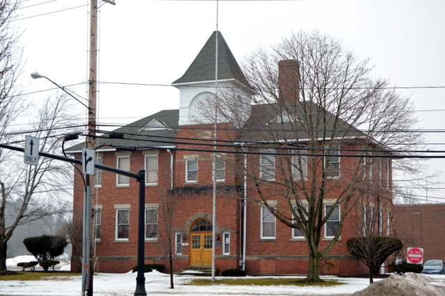
Photo: Nyttend (Wikimedia Commons), public domain · Wikimedia Commons
Local history sources: en.wikipedia.org · case.edu · commons.wikimedia.org · en.wikipedia.org
Historic places
1 place in Mayfield on the National Register of Historic Places. Press a pin or a name for its whole record.
-
Old Center SchoolBuilding · Mayfield Village · listed 1973
- Address
- 784 S.O.M. Center Rd.
- Where
- Mayfield Village, Cuyahoga County · ZIP 44143
- What it is
- Building
- Listed on the National Register
- 1973
- NRIS reference number
- 73001426
- Coordinates
- 41.53991, -81.43909
National Register file (NPS) ↗ Search Wikipedia ↗ Street map and directions ↗ On the Cracked Buckeye map
Source: National Park Service, National Register of Historic Places point file. The listing year is shown where NPS's certification date agrees with the listing's reference number. Listing recognizes significance; it does not restrict a private owner.
Water
The Five Mile Crib, a small structure about 5 miles out in Lake Erie north of Cleveland's Edgewater Park The water here
- Cleveland Public Water System100% of residentsLake Erie
Hospitals, fire stations and more
Inside Mayfield's boundary: 1 nursing home, 1 fire or EMS station, 3 public schools, 1 poor-rated bridge, 1 library, 1 museum, 1 police station, 4 public charging sites, 4 Toxics Release Inventory facilities and 3 spill cases. Press a pin or a name for its whole record and its source.
Nursing homes (1)
-
Altercare of Mayfield Village, Inc3 of 5 stars · Mayfield Village
- Address
- 290 North Commons Blvd, Mayfield Village, OH 44143
- Certified beds
- 52
- Residents on an average day
- 44
- Medicare overall rating
- 3 of 5 stars
- Health inspections
- 2 of 5 stars
- Staffing
- 3 of 5 stars
- Quality measures
- 5 of 5 stars
- Penalties since 2023
- 1 fine totalling $72,646 (latest 2026-05-14)
- Ownership
- For profit - Corporation
- Chain
- ALTERCARE
- Takes
- Medicare and Medicaid
- Phone
- (440) 473-9411
- Medicare ID
- 366267
Medicare Care Compare ↗ CMS nursing home data (source) ↗ Street map and directions ↗
Source: CMS Care Compare nursing home provider and penalties files; Medicare star ratings run 1 to 5.
Fire and EMS stations (1)
-
Mayfield Village Fire DepartmentMayfield Village
- Address
- 770 SOM Center Road, Mayfield Village, OH 44143
- Coordinates
- 41.54058, -81.43950
USGS National Map structures (source) ↗ Street map and directions ↗
Source: USGS National Map structures (most Ohio records last updated 2019 to 2022), checked against the Columbus and Cleveland station lists. The department that answers a call is set by jurisdiction and mutual aid, not by distance.
Public schools (3)
-
Mayfield Center Elementary School4.5 of 5 stars · Mayfield
- Address
- 6625 Wilson Mills Rd, Mayfield, OH 44143
- School district
- Mayfield City School District
- Kind (NCES)
- Regular School
- Students, 2023-24
- 481
- Teachers (full-time equivalent)
- 27
- Report card, 2025-26
- 4.5 of 5 stars
- Performance index
- 91.1%
- Ohio building IRN
- 023317
- NCES school ID
- 390443701298
NCES school record ↗ Ohio School Report Card ↗ Street map and directions ↗
-
Mayfield High School5 of 5 stars · Cleveland
- Address
- 6116 Wilson Mills Rd, Cleveland, OH 44143
- School district
- Mayfield City School District
- Kind (NCES)
- Regular School
- Students, 2023-24
- 1,574
- Teachers (full-time equivalent)
- 80
- Report card, 2025-26
- 5 of 5 stars
- Performance index
- 90.6%
- Four-year graduation rate
- 97%
- Ohio building IRN
- 023325
- NCES school ID
- 390443701297
NCES school record ↗ Ohio School Report Card ↗ Street map and directions ↗
-
Mayfield PreschoolMayfield Village
- Address
- 6116 Wilson Mills Rd, Mayfield Village, OH 44143
- Kind (NCES)
- Regular School
- Students, 2023-24
- 125
- Teachers (full-time equivalent)
- 7
- NCES school ID
- 390443701301
Source: NCES EDGE public school locations 2024-25 and Common Core of Data 2023-24 (type, students, teachers); Ohio School Report Cards 2025-26 (Department of Education and Workforce), matched by name within the district.
Bridges rated poor (1)
-
Highland Rd over Ir271&271x (highland)Poor · built 1963
- Condition
- Poor: a deck, superstructure, substructure or culvert rated 4 or below on the 0 to 9 scale
- What it is
- Bridge
- Built
- 1963
- Length
- 118 ft
- Owner
- State
- Vehicles a day
- 8,439
- Coordinates
- 41.55244, -81.44838
National Bridge Inventory (source) ↗ Street map and directions ↗
Source: FHWA National Bridge Inventory 2025. "Poor" means one major part rated 4 or below on the 0 to 9 scale; it calls for repair, not closing, unless the state posts or closes the bridge.
Public libraries (1)
-
Mayfield Branch LibraryBranch · Mayfield Village
- Address
- 500 Som Center Road, Mayfield Village, OH 44143
- What it is
- Branch
- Library system
- Cuyahoga County Public Library
- Open
- 3,501 hours a year, 52 weeks
- Building
- 34,620 sq ft
- System's visits, FY2024
- 3,917,784
- System's loans, FY2024
- 11,584,178
- People the system serves
- 626,288
- Phone
- (440) 473-0350
IMLS Public Libraries Survey (source) ↗ Street map and directions ↗
Source: IMLS Public Libraries Survey FY2024 (outlets and their systems). Any Ohio resident can get a free card at any Ohio public library.
Museums, historical societies, gardens and zoos (1)
-
Mayfield Township Historical SocietyHistorical society · Mayfield Village
- What it is
- Historical society
- City
- Mayfield Village
- Coordinates
- 41.55009, -81.43931
Search Wikipedia ↗ IMLS Museum Data Files (source) ↗ Street map and directions ↗
The museum list is IMLS's 2018 file; a museum may have closed or moved since.
Source: IMLS Museum Data Files, 2018.
Police stations (1)
-
Mayfield Village Police DepartmentMayfield Village
- Address
- 620 SOM Center Road, Mayfield Village, OH 44143
- Coordinates
- 41.54866, -81.43982
USGS National Map structures (source) ↗ Street map and directions ↗
Source: USGS National Map structures, police stations, corrected and completed by hand (September 2026). The department that answers a call is set by jurisdiction, not by distance.
Public EV charging (4)
-
Deacons Chrysler Dodge Jeep Ram DC fast2 DC fast · Mayfield Village
- Address
- 835 SOM Center Road, Mayfield Village, OH 44143
- Ports
- 2 DC fast
- Plugs
- CCS
- Network
- SYNERGEV
- Hours
- 24 hours daily
- Phone
- 888-807-4522
Station Locator (NREL) ↗ Alternative Fuels Data Center (source) ↗ Street map and directions ↗
-
HI MAYFIELD STATION 012 Level 2 · Mayfield
- Address
- 780 Beta Dr, Mayfield, OH 44143
- Ports
- 2 Level 2
- Plugs
- J1772
- Network
- ChargePoint Network
- Hours
- 24 hours daily
- Phone
- 888-758-4389
Station Locator (NREL) ↗ Alternative Fuels Data Center (source) ↗ Street map and directions ↗
-
Holiday Inn Cleveland-Mayfield, an IHG Hotel - Tesla Destination4 Level 2 · Mayfield
- Address
- 780 Beta Dr, Mayfield, OH 44143
- Ports
- 4 Level 2
- Plugs
- J1772, Tesla (NACS)
- Network
- Tesla Destination
- Phone
- 877-798-3752
Station Locator (NREL) ↗ Alternative Fuels Data Center (source) ↗ Street map and directions ↗
-
Mayfield Village Civic Center DC fast1 DC fast · Mayfield
- Address
- 6622 Wilson Mills Road, Mayfield, OH 44143
- Ports
- 1 DC fast
- Plugs
- CCS, CHAdeMO
- Network
- FLO
- Hours
- 24 hours daily
- Phone
- 888-356-8911
Station Locator (NREL) ↗ Alternative Fuels Data Center (source) ↗ Street map and directions ↗
Source: NREL Alternative Fuels Data Center station list (May 2026), public and open stations, the posts at one address counted as one site.
Facilities reporting toxic releases (4)
-
Lad Technology IncToxics Release Inventory · Mayfield Village
- Address
- 730 Beta Dr., Unit B, Mayfield Village, OH 44143
- County
- Cuyahoga County
- Status
- Reports to the Toxics Release Inventory (active)
- EPA program ID
- 44143LDTCH73BET
- EPA registry ID
- 110030905297
EPA facility record ↗ EPA Facility Registry Service (source) ↗ Street map and directions ↗
-
Mayfran International IncToxics Release Inventory · Cleveland
- Address
- 6650 Beta Drive, Cleveland, OH 44143
- County
- Cuyahoga County
- Status
- Reports to the Toxics Release Inventory (active)
- EPA program ID
- 44143MYFRN6650B
- EPA registry ID
- 110004599104
EPA facility record ↗ EPA Facility Registry Service (source) ↗ Street map and directions ↗
-
Stanley WorksToxics Release Inventory · Cleveland
- Address
- 700 Beta Dr., Cleveland, OH 44143
- County
- Cuyahoga County
- Status
- Reports to the Toxics Release Inventory (active)
- EPA program ID
- 44143STNLY700BE
- EPA registry ID
- 110013287460
EPA facility record ↗ EPA Facility Registry Service (source) ↗ Street map and directions ↗
-
Techtron Systems IncToxics Release Inventory · Cleveland
- Address
- 760 Beta Dr, Cleveland, OH 44143
- County
- Cuyahoga County
- Status
- Reports to the Toxics Release Inventory (active)
- EPA program ID
- 44143TCHTR76BET
- EPA registry ID
- 110004735920
EPA facility record ↗ EPA Facility Registry Service (source) ↗ Street map and directions ↗
Source: EPA Facility Registry Service, Toxics Release Inventory reporters. Reporting a release is required of large users of listed chemicals; it is not by itself a violation.
Spills reported since 2021 (3)
-
Fuel Diesel / Diesel Fuel (Vehicle On Or Off Road)2024-08-19 · Mayfield
- Reported
- 2024-08-19
- What spilled
- Fuel Diesel / Diesel Fuel (Vehicle On Or Off Road)
- Largest amount reported
- 100 gallons
- Where
- Mayfield, Cuyahoga County
- Ohio EPA district office
- NEDO
- Ohio EPA case number
- 2408EPA0001436
Ohio EPA spill reports (source) ↗ Street map and directions ↗
-
Foam Reached water2021-12-21 · Mayfield
- Reported
- 2021-12-21
- What spilled
- Foam
- Reached a waterway
- 99 - Unnamed
- Where
- Mayfield, Cuyahoga County
- Ohio EPA district office
- NEDO
- Ohio EPA case number
- 2112EPA0001894
Ohio EPA spill reports (source) ↗ Street map and directions ↗
-
Oil Transformer Non Pcb2021-07-25 · Mayfield
- Reported
- 2021-07-25
- What spilled
- Oil Transformer Non Pcb
- Where
- Mayfield, Cuyahoga County
- Ohio EPA district office
- NEDO
- Ohio EPA case number
- 2107EPA0001128
Ohio EPA spill reports (source) ↗ Street map and directions ↗
Source: Ohio EPA emergency response spill reports, 2021 to September 2026, one point per case where Ohio EPA placed it. A report is what the caller or responder recorded; amounts are often blank or estimated.
Its ZIP codes
Each ZIP code that touches Mayfield, with the share of its residents who live here and the same headline figures as the ZIP page.
| ZIP | Share | Water | Radon | Home value | Schools | Flood |
|---|---|---|---|---|---|---|
| 44040 Gates Mills | 24% | The Five Mile Crib, a small structure about 5 miles out in Lake Erie north of Cleveland's Edgewater Park | 3.1 pCi/L average radon | Median year built 1963 | Mayfield City · 5 stars overall | 2.2% of residents in the 1% floodplain |
| 44143 Richmond Heights and Cleveland | 10% | Lake Erie, through a 10-foot tunnel running nearly 4 miles offshore from northeast Cleveland's lakefront | 2.8 pCi/L average radon | Median year built 1969 | Mayfield City · 5 stars overall | 1.0% of residents in the 1% floodplain |
Local government
Who holds office in Mayfield, how its elections and ballot issues came out, and the state auditor's record.
Auditor of State record
- No fiscal caution, watch or emergency on the Auditor of State's lists.
- Financial Audit, 2025, released 2026-07-09
- Financial Audit, 2024, released 2026-01-13
- Financial Audit, 2023, released 2025-02-18
The county
Cuyahoga County: 52 ZIP codes, 59 cities, villages and townships, 1,270,867 people.
Nearby places
Rain and snow
How much has actually fallen on Mayfield, day by day, from 1871 to now. Daily totals, not averages.
- rain, last 30 days
- 1.74 in
- 2026-09-29 to 2026-10-28
- rain so far in 2026
- 34.2 in
- 3.6 in below normal for the date
- snow so far in 2026
- 42.5 in
- a normal year brings 75.7 in
- a normal year
- 45.8 in
- average of 30 years, 1991-2020
| Month | Rain (in) | Snow (in) | Days counted |
|---|---|---|---|
| October 2026 | 1.74 | — | 28 |
| September 2026 | 3.24 | — | 30 |
| August 2026 | 7.27 | — | 31 |
| July 2026 | 2.72 | — | 31 |
| June 2026 | 2.85 | — | 30 |
| May 2026 | 3.97 | — | 31 |
| April 2026 | 6.14 | 0.1 | 30 |
| March 2026 | 3.70 | 1.5 | 31 |
| February 2026 | 0.53 | 8.0 | 28 |
| January 2026 | 2.07 | 32.9 | 31 |
| December 2025 | 2.78 | 15.0 | 31 |
| November 2025 | 2.06 | 9.6 | 30 |
| Wettest year | 2011 — 70.5 in |
|---|---|
| Driest year | 1963 — 22.9 in |
| Snowiest year | 1969 — 141.8 in |
| Wettest day on record | 28 July 2006 — 4.96 in |
| Heaviest snowfall in a day | 10 December 2016 — 13.81 in |
| Deepest snow on the ground | 14 November 1996 — 33.66 in |
Mostly estimated. Only 2% of these days come from a gauge standing inside Mayfield - the rest are worked out from the nearest gauges around it, so read them as close estimates rather than readings.
56,914 days of records, 1871-01-01 to 2026-10-28. Source: NOAA NCEI GHCN-Daily, 3,240 gauges in and around Ohio. A day is "gauged" when a gauge standing inside the boundary reported it, and the value is the mean of those gauges. Otherwise it is interpolated by inverse distance from every gauge reporting within 50 miles. Nothing is carried forward, back-filled or smoothed. Against NOAA nClimDiv county monthly precipitation over 136,848 complete county-months (checked 2026-10-31): correlation 0.9515, median absolute difference 0.217 in a month. Built 2026-10-31 from the Cracked Buckeye precipitation archive. Snow is the softer number — snowfall is measured by hand with a ruler, no agency publishes a gridded county snowfall series, and blowing snow defeats every observer.
Environmental permits and filings
What Ohio EPA has on file for Mayfield: permits, inspections, violations, cleanups and the state loans behind sewer and water work. Every line links to the agency's own document.
- facilities and sites on file
- 8
- those placed on the map inside Mayfield
| Program | Facilities and sites |
|---|---|
| Hazardous waste | 3 |
| Wastewater and stormwater discharge | 3 |
| Air pollution | 1 |
| Composting | 1 |
Source: Ohio EPA eDocument portal (edocpub.epa.ohio.gov), indexed 2026-10-14. Facilities are placed on the map from Ohio EPA's own map layers, EPA's Facility Registry, coordinates written in the filings, or a geocoded street address. A permit filed under a private person's name (most are household septic systems) is counted but never named, placed or linked; licenses for individual workers and open-burning notices are left out entirely.
Quick answers
What county is Mayfield, Ohio in?
Mayfield is a village in Cuyahoga County, Ohio, with 3,356 residents.
When was Mayfield, Ohio founded?
Mayfield was settled 1805 (families from Ontario County, New York); incorporated Mayfield Township formed June 14, 1819 from Chagrin Township; Mayfield Village incorporated March 21, 1921. Source
What ZIP code is Mayfield, Ohio?
Mayfield is served by ZIP codes 44040 and 44143; 44040 holds the largest share of its residents.
Where does Mayfield, Ohio get its water?
The main water source for Mayfield (Cleveland Public Water System): The Five Mile Crib, a small structure about 5 miles out in Lake Erie north of Cleveland's Edgewater Park.
Cite this page
Cite this page as:
Cracked Buckeye, "Mayfield, Cuyahoga County", https://crackedbuckeye.com/place/mayfield/, built 2026-10-31, accessed [date].
How to cite · Report a correction · Built 2026-10-31
